Hope you have your plan ready to execute.SFLcane wrote:Um holy moly… this is Andy’s model which did very well with Ian.
ATL: NICOLE - Models
Moderator: S2k Moderators
-
jlauderdal
- S2K Supporter

- Posts: 7240
- Joined: Wed May 19, 2004 5:46 am
- Location: NE Fort Lauderdale
- Contact:
Re: RE: Re: ATL: INVEST 98L - Models
4 likes

Re: ATL: INVEST 98L - Models
LarryWx wrote:0Z ICON comes well inland into FL instead of skirting the coast due to stronger ridging to the NW and N.
0z Icon makes it into the Gulf.
1 likes


-
Blown Away

- S2K Supporter
- Posts: 10253
- Joined: Wed May 26, 2004 6:17 am
Re: ATL: INVEST 98L - Models
00z GFS
WOW!
JLauderdale???
1 likes
Hurricane Eye Experience: David 79, Irene 99, Frances 04, Jeanne 04, Wilma 05… Hurricane Brush Experience: Andrew 92, Erin 95, Floyd 99, Matthew 16, Irma 17, Ian 22, Nicole 22…
Re: ATL: INVEST 98L - Models
It gets back into the Gulf just south of Tampa and bends slowly up toward the Big Bend, takes all day to do it Friday once back in the Gulf. Tampa winds up on the dirty side this time (for in Bay surge).
1 likes
-
Meteorcane

- Category 2

- Posts: 559
- Joined: Thu Jul 21, 2011 6:49 am
- Location: North Platte Nebraska
Re: ATL: INVEST 98L - Models
Not sure what to make of that GFS run, shows a very elongated system initially with a western vortex rotating around the larger UL system before finally consolidating further SW. I am curious how much this initial mesoscale "cyclonic" interaction impacts the ultimate track, or if it actually occurs.
0 likes
-
Blown Away
- S2K Supporter
- Posts: 10253
- Joined: Wed May 26, 2004 6:17 am
Re: ATL: INVEST 98L - Models
00z GFS… Legendary run…
0 likes
Hurricane Eye Experience: David 79, Irene 99, Frances 04, Jeanne 04, Wilma 05… Hurricane Brush Experience: Andrew 92, Erin 95, Floyd 99, Matthew 16, Irma 17, Ian 22, Nicole 22…

-
jlauderdal
- S2K Supporter
- Posts: 7240
- Joined: Wed May 19, 2004 5:46 am
- Location: NE Fort Lauderdale
- Contact:
Re: RE: Re: ATL: INVEST 98L - Models
Too far south, stuart area and north..nonetheless, beware of models underdoing ridges, seen that more than a few timesBlown Away wrote:
00z GFS
WOW!
JLauderdale???
1 likes


Re: ATL: INVEST 98L - Models
BobHarlem wrote:It gets back into the Gulf just south of Tampa and bends slowly up toward the Big Bend, takes all day to do it Friday once back in the Gulf. Tampa winds up on the dirty side this time (for in Bay surge).
Yes would be a bad scenario for Tampa Bay getting the surge we were supposed to get with Ian, albeit much weaker.
0 likes

Re: RE: Re: ATL: INVEST 98L - Models
jlauderdal wrote:Too far south, stuart area and north..nonetheless, beware of models underdoing ridges, seen that more than a few timesBlown Away wrote:[url]https://i.postimg.cc/jdSD35Z4/floop-gfs-2022110700-sfcwind-mslp-swatl-2.gif [/url]
00z GFS
WOW!
JLauderdale???
Ensembles have always shown the possibility of a Miami/Broward landfall
1 likes
-
Spacecoast

- Category 2
- Posts: 773
- Joined: Thu Aug 31, 2017 2:03 pm

Re: ATL: INVEST 98L - Models
0Z UKMET: landfall 7AM Thursday barely north of Melbourne moving WNW. That's compared to Stuart also near 7AM on the 12Z. Then it goes WNW through Orlando and to the far NE GOM followed by going back inland to near Tallahassee:
TROPICAL STORM 98L ANALYSED POSITION : 23.8N 67.5W
ATCF IDENTIFIER : AL982022
LEAD CENTRAL MAXIMUM WIND
VERIFYING TIME TIME POSITION PRESSURE (MB) SPEED (KNOTS)
-------------- ---- -------- ------------- -------------
0000UTC 07.11.2022 0 23.8N 67.5W 1006 33
1200UTC 07.11.2022 12 26.1N 69.2W 1005 39
0000UTC 08.11.2022 24 26.3N 70.6W 1003 37
1200UTC 08.11.2022 36 27.1N 70.8W 1003 35
0000UTC 09.11.2022 48 28.1N 72.2W 1004 39
1200UTC 09.11.2022 60 27.4N 75.6W 1003 44
0000UTC 10.11.2022 72 26.6N 77.8W 1001 41
1200UTC 10.11.2022 84 28.1N 80.4W 1000 43
0000UTC 11.11.2022 96 29.2N 83.2W 998 32
1200UTC 11.11.2022 108 30.3N 84.1W 1001 26
0000UTC 12.11.2022 120 32.5N 82.5W 1003 26
1200UTC 12.11.2022 132 CEASED TRACKING
0 likes
Personal Forecast Disclaimer:
The posts in this forum are NOT official forecasts and should not be used as such. They are just the opinion of the poster and may or may not be backed by sound meteorological data. They are NOT endorsed by any professional institution or storm2k.org. For official information, please refer to the NHC and NWS products.
The posts in this forum are NOT official forecasts and should not be used as such. They are just the opinion of the poster and may or may not be backed by sound meteorological data. They are NOT endorsed by any professional institution or storm2k.org. For official information, please refer to the NHC and NWS products.
-
Blown Away
- S2K Supporter
- Posts: 10253
- Joined: Wed May 26, 2004 6:17 am
Re: ATL: INVEST 98L - Models
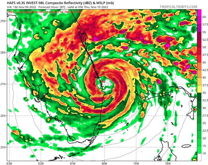
00z HMON… 982mb landfall @WPB
0 likes
Hurricane Eye Experience: David 79, Irene 99, Frances 04, Jeanne 04, Wilma 05… Hurricane Brush Experience: Andrew 92, Erin 95, Floyd 99, Matthew 16, Irma 17, Ian 22, Nicole 22…
-
Blown Away
- S2K Supporter
- Posts: 10253
- Joined: Wed May 26, 2004 6:17 am
Re: ATL: INVEST 98L - Models
LarryWx wrote:0Z UKMET: landfall 7AM Thursday barely north of Melbourne moving WNW. That's compared to Stuart also near 7AM on the 12Z. Then it goes WNW through Orlando and to the far NE GOM followed by going back inland to near Tallahassee:TROPICAL STORM 98L ANALYSED POSITION : 23.8N 67.5W
ATCF IDENTIFIER : AL982022
LEAD CENTRAL MAXIMUM WIND
VERIFYING TIME TIME POSITION PRESSURE (MB) SPEED (KNOTS)
-------------- ---- -------- ------------- -------------
0000UTC 07.11.2022 0 23.8N 67.5W 1006 33
1200UTC 07.11.2022 12 26.1N 69.2W 1005 39
0000UTC 08.11.2022 24 26.3N 70.6W 1003 37
1200UTC 08.11.2022 36 27.1N 70.8W 1003 35
0000UTC 09.11.2022 48 28.1N 72.2W 1004 39
1200UTC 09.11.2022 60 27.4N 75.6W 1003 44
0000UTC 10.11.2022 72 26.6N 77.8W 1001 41
1200UTC 10.11.2022 84 28.1N 80.4W 1000 43
0000UTC 11.11.2022 96 29.2N 83.2W 998 32
1200UTC 11.11.2022 108 30.3N 84.1W 1001 26
0000UTC 12.11.2022 120 32.5N 82.5W 1003 26
1200UTC 12.11.2022 132 CEASED TRACKING
Models slowly smoothing that big N hump into a more W track it seems?
1 likes
Hurricane Eye Experience: David 79, Irene 99, Frances 04, Jeanne 04, Wilma 05… Hurricane Brush Experience: Andrew 92, Erin 95, Floyd 99, Matthew 16, Irma 17, Ian 22, Nicole 22…
-
Blown Away
- S2K Supporter
- Posts: 10253
- Joined: Wed May 26, 2004 6:17 am
Re: ATL: INVEST 98L - Models
00z HWRF… 979 mb Cat 1 into @Stuart…
Last edited by Blown Away on Mon Nov 07, 2022 12:51 am, edited 1 time in total.
1 likes
Hurricane Eye Experience: David 79, Irene 99, Frances 04, Jeanne 04, Wilma 05… Hurricane Brush Experience: Andrew 92, Erin 95, Floyd 99, Matthew 16, Irma 17, Ian 22, Nicole 22…
-
Blown Away
- S2K Supporter
- Posts: 10253
- Joined: Wed May 26, 2004 6:17 am
Re: ATL: INVEST 98L - Models
Larry, notice how a few models show mb’s dropping after making landfall? EURO, HWRF…
1 likes
Hurricane Eye Experience: David 79, Irene 99, Frances 04, Jeanne 04, Wilma 05… Hurricane Brush Experience: Andrew 92, Erin 95, Floyd 99, Matthew 16, Irma 17, Ian 22, Nicole 22…
Re: ATL: INVEST 98L - Models
Blown Away wrote:Larry, notice how a few models show mb’s dropping after making landfall? EURO, HWRF…
Maybe the Euro did that because it isn't purely tropical on the model?
By the way, the 0Z Euro at 72 is barely south of the 18Z at 78.
It is offshore just W of Tampa at 96, which is just NW of 12Z run at 108.
0 likes
Personal Forecast Disclaimer:
The posts in this forum are NOT official forecasts and should not be used as such. They are just the opinion of the poster and may or may not be backed by sound meteorological data. They are NOT endorsed by any professional institution or storm2k.org. For official information, please refer to the NHC and NWS products.
The posts in this forum are NOT official forecasts and should not be used as such. They are just the opinion of the poster and may or may not be backed by sound meteorological data. They are NOT endorsed by any professional institution or storm2k.org. For official information, please refer to the NHC and NWS products.
-
Blown Away
- S2K Supporter
- Posts: 10253
- Joined: Wed May 26, 2004 6:17 am
Re: ATL: INVEST 98L - Models
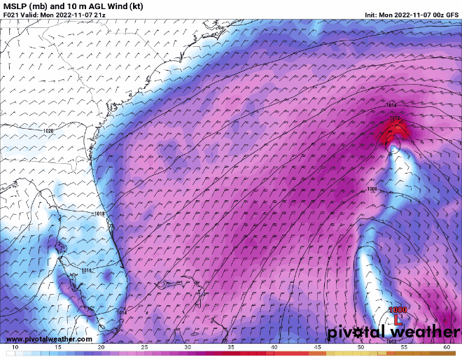
00z EURO… Landfall near WPB moving WNW across the FL Peninsula… 998 mb, slightly stronger…
0 likes
Hurricane Eye Experience: David 79, Irene 99, Frances 04, Jeanne 04, Wilma 05… Hurricane Brush Experience: Andrew 92, Erin 95, Floyd 99, Matthew 16, Irma 17, Ian 22, Nicole 22…
Who is online
Users browsing this forum: No registered users and 12 guests