3090 wrote:Frank P wrote:Hard to discern any center at 13.5 looking at the latest sat loops
From an infrared image?
Yes
Moderator: S2k Moderators

3090 wrote:Frank P wrote:Hard to discern any center at 13.5 looking at the latest sat loops
From an infrared image?
aspen wrote:Possible center at 14.7N/79.3W, pressure 1000 mbar.
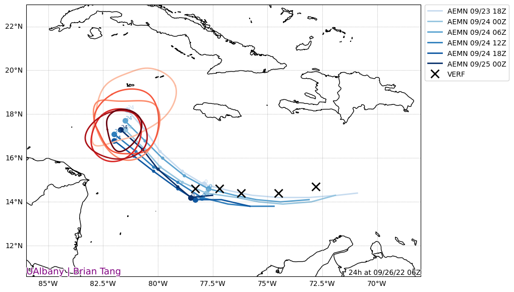
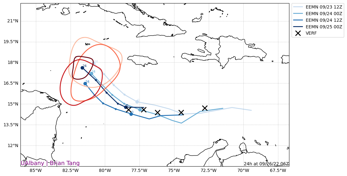
redingtonbeach wrote:I'm certainly no Met but it appears to me that the GFS ensembles initialized the latest run south (20 - 30 miles?) of the verified position. Of course, is there a TRUE verified position yet may be the real question. On the other hand, the Euro initialized its run significantly closer to the "verified" position.
https://i.postimg.cc/VsDftMNW/AVNO-enstrendtrack-0.png
GFS
https://i.postimg.cc/SKgXxPHc/ECMF-enstrendtrack-0.png
Euro
That said, if we assume the GFS initialized too far south, then should one also assume the GFS track may also be too far west at 24/48/72 hours AND too slow?


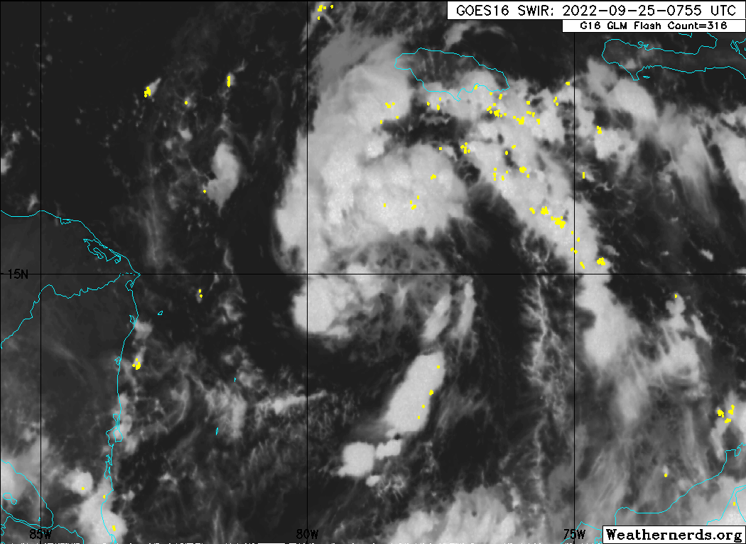
wxman57 wrote:I'd look north of 15N for the center. That stuff down south is insignificant. Strong mid-level center around 15.5N. Surface center will form/relocate there. Still looks like northern FL Peninsula, north of Tampa. NHC is now acknowledging the strong shear that would lead to weakening prior to landfall. However, the farther (farther = distance, not "further") south it impacts Florida, the stronger it would be at landfall. My track is east of their track (along TVCN) because TVCN is likely being pulled too far east by the errant (likely) GFS and HWRF. Starting on advisory...


Blown Away wrote:[url]https://i.postimg.cc/LXdnN4xD/74506634.gif [/url]
Maybe no well defined at the surface, but you can see the low level clouds circulating @15N/79W. Ian’s has bigger problems if it’s down by 13.5.

BobHarlem wrote:wxman57 wrote:I'd look north of 15N for the center. That stuff down south is insignificant. Strong mid-level center around 15.5N. Surface center will form/relocate there. Still looks like northern FL Peninsula, north of Tampa. NHC is now acknowledging the strong shear that would lead to weakening prior to landfall. However, the farther (farther = distance, not "further") south it impacts Florida, the stronger it would be at landfall. My track is east of their track (along TVCN) because TVCN is likely being pulled too far east by the errant (likely) GFS and HWRF. Starting on advisory...
" My track is east of their track (along TVCN) because TVCN is likely being pulled too far east by the errant (likely) GFS and HWRF."
Assume you meant "pulled too far west" there

wxman57 wrote:I'd look north of 15N for the center. That stuff down south is insignificant. Strong mid-level center around 15.5N. Surface center will form/relocate there. Still looks like northern FL Peninsula, north of Tampa. NHC is now acknowledging the strong shear that would lead to weakening prior to landfall. However, the farther (farther = distance, not "further") south it impacts Florida, the stronger it would be at landfall. My track is east of their track (along TVCN) because TVCN is likely being pulled too far west by the errant (likely) GFS and HWRF. Starting on advisory...

wxman57 wrote:I'd look north of 15N for the center. That stuff down south is insignificant. Strong mid-level center around 15.5N. Surface center will form/relocate there. Still looks like northern FL Peninsula, north of Tampa. NHC is now acknowledging the strong shear that would lead to weakening prior to landfall. However, the farther (farther = distance, not "further") south it impacts Florida, the stronger it would be at landfall. My track is east of their track (along TVCN) because TVCN is likely being pulled too far west by the errant (likely) GFS and HWRF. Starting on advisory...
chris_fit wrote:wxman57 wrote:I'd look north of 15N for the center. That stuff down south is insignificant. Strong mid-level center around 15.5N. Surface center will form/relocate there. Still looks like northern FL Peninsula, north of Tampa. NHC is now acknowledging the strong shear that would lead to weakening prior to landfall. However, the farther (farther = distance, not "further") south it impacts Florida, the stronger it would be at landfall. My track is east of their track (along TVCN) because TVCN is likely being pulled too far west by the errant (likely) GFS and HWRF. Starting on advisory...
As always, thanks for your analysis.
Yes or No - If you were Tampa Area (Bradenton) - Would you be shuttering up?
My plan is to wait until this afternoon models, if E shift in most guidance, shutter up - otherwise no. Wise plan?


aspen wrote:Keldeo1997 wrote:https://twitter.com/DerekOrtt/status/1573969695178465280
Strange how this is in the most favorable environment of any storm this season, and yet it’s the only one to struggle with low-level divergence. None of the models picked this up.
StPeteMike wrote:chris_fit wrote:wxman57 wrote:I'd look north of 15N for the center. That stuff down south is insignificant. Strong mid-level center around 15.5N. Surface center will form/relocate there. Still looks like northern FL Peninsula, north of Tampa. NHC is now acknowledging the strong shear that would lead to weakening prior to landfall. However, the farther (farther = distance, not "further") south it impacts Florida, the stronger it would be at landfall. My track is east of their track (along TVCN) because TVCN is likely being pulled too far west by the errant (likely) GFS and HWRF. Starting on advisory...
As always, thanks for your analysis.
Yes or No - If you were Tampa Area (Bradenton) - Would you be shuttering up?
My plan is to wait until this afternoon models, if E shift in most guidance, shutter up - otherwise no. Wise plan?
Would also wait til probably whatever comes out either this afternoon or even this evening. Almost all the models have been pretty set with between the mouth of Tampa Bay and Big Bend area.
Users browsing this forum: No registered users and 36 guests


