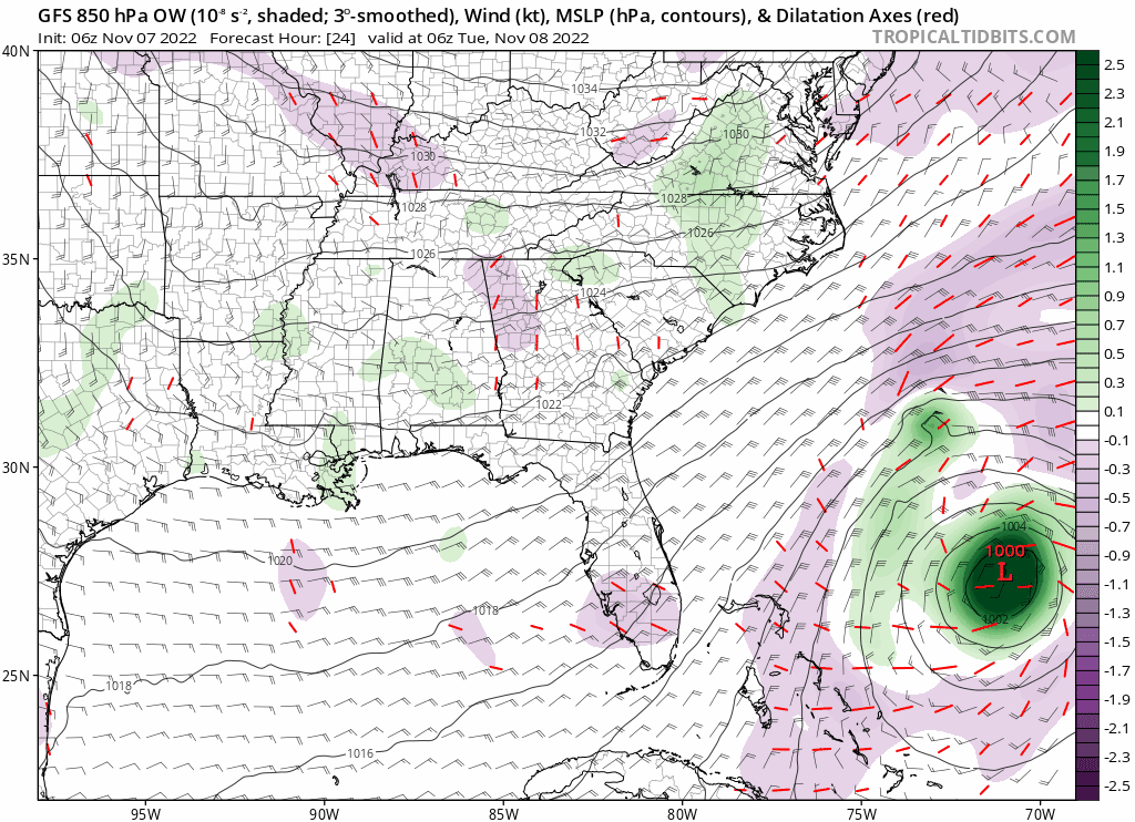
ATL: NICOLE - Models
Moderator: S2k Moderators
- Blown Away
- S2K Supporter
- Posts: 9874
- Joined: Wed May 26, 2004 6:17 am
Re: ATL: NICOLE - Models
0 likes
Hurricane Eye Experience: David 79, Irene 99, Frances 04, Jeanne 04, Wilma 05... EYE COMING MY WAY IN 2024…
Hurricane Brush Experience: Andrew 92, Erin 95, Floyd 99, Matthew 16, Irma 17, Ian 22, Nicole 22…
-
- S2K Supporter
- Posts: 6811
- Joined: Wed May 19, 2004 5:46 am
- Location: NE Fort Lauderdale
- Contact:
Re: RE: Re: ATL: NICOLE - Models
Stop, it was boca not pompano, ha. Gfs hanging tough with this southerly move, nhc staying north, for now.
3 likes
- Blown Away
- S2K Supporter
- Posts: 9874
- Joined: Wed May 26, 2004 6:17 am
Re: ATL: NICOLE - Models
0 likes
Hurricane Eye Experience: David 79, Irene 99, Frances 04, Jeanne 04, Wilma 05... EYE COMING MY WAY IN 2024…
Hurricane Brush Experience: Andrew 92, Erin 95, Floyd 99, Matthew 16, Irma 17, Ian 22, Nicole 22…
Re: ATL: NICOLE - Models
06z GFS and 0z Euro are fairly close, both have landfall in Palm Beach County. What is interesting is how faster the GFS now is when the last couple of days was much slower, might be the reason why it brings Nicole far offshore into the GOM.
Euro continues its solution of Nicole staying subtropical which the NHC is dismissing its solution.
1 likes
Re: ATL: NICOLE - Models
Interesting that both GFS and Euro show low windshear and moist environment over the eastern GOM, with both models now showing it to reach the eastern GOM before the sharp turn to the NE.
I guess Nicole is going to be full of surprises for us.
2 likes
- DESTRUCTION5
- Category 5
- Posts: 4391
- Age: 42
- Joined: Wed Sep 03, 2003 11:25 am
- Location: Stuart, FL
Re: ATL: NICOLE - Models
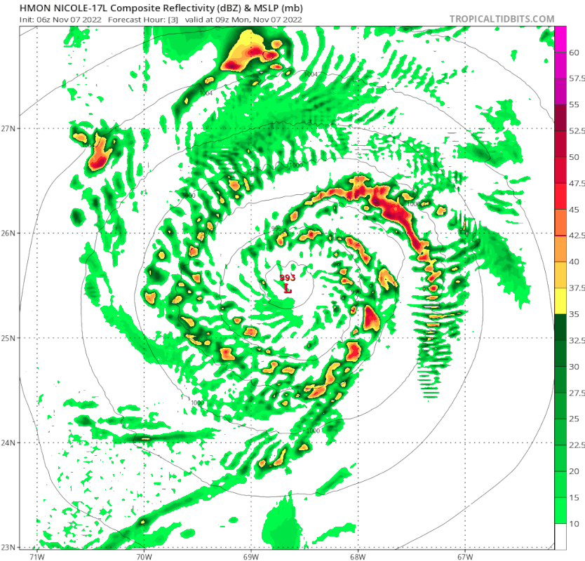
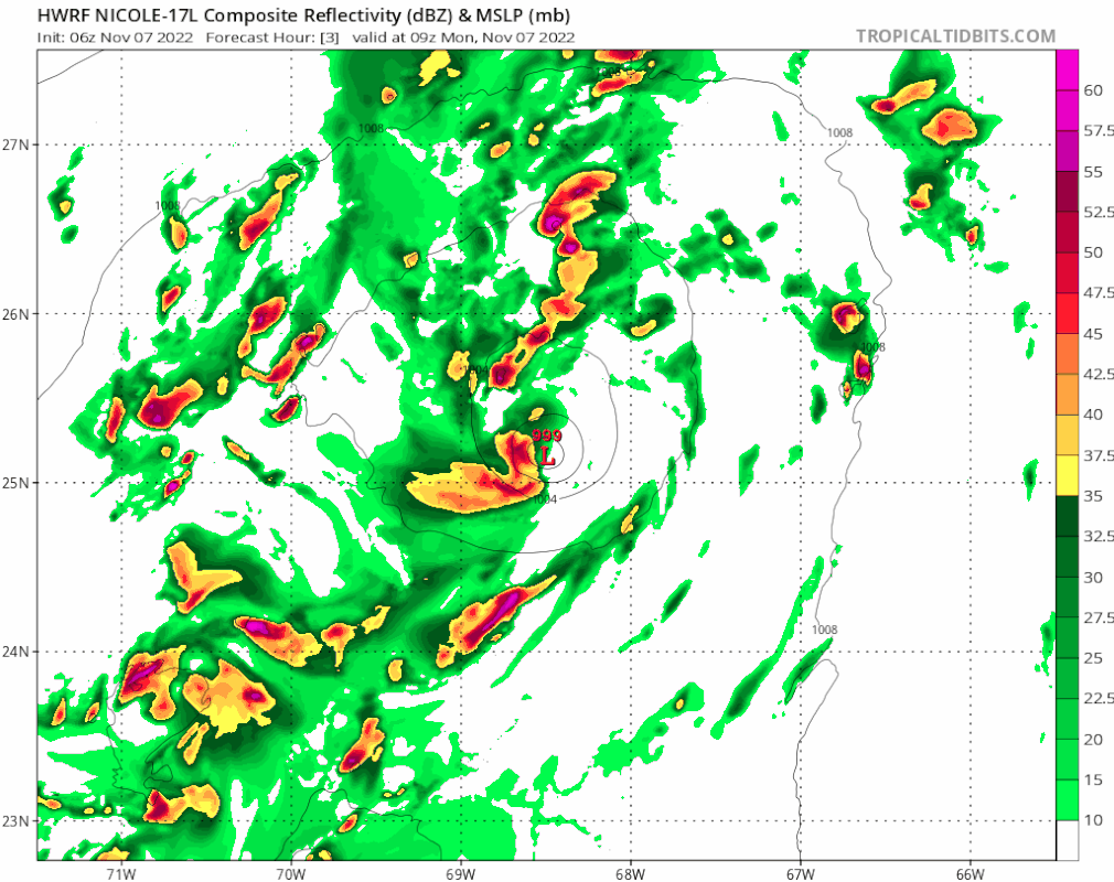
Blown Away wrote:[url]https://i.postimg.cc/4xg9xCcF/hwrf-ref-17-L-fh3-75.gif [/url]
06z HWRF… Cat 1 into WPB; Big circulation/eye; 06z models coming in stronger than 00z…
Many models including HWRF intensify her all the way to landfall. Bastardi is thinking low end cat 2.
2 likes
GATOR NATION IS E V E R Y W H E R E !
Re: ATL: NICOLE - Models
So has ICON changed in the last 24 hours which I think had it landing more South ?
0 likes
- Blown Away
- S2K Supporter
- Posts: 9874
- Joined: Wed May 26, 2004 6:17 am
Re: ATL: NICOLE - Models
cane5 wrote:So has ICON changed in the last 24 hours which I think had it landing more South ?
No, the ICON has been a north outlier mostly from the beginning. It did shift some S from its Daytona area to near Port St Lucie.
0 likes
Hurricane Eye Experience: David 79, Irene 99, Frances 04, Jeanne 04, Wilma 05... EYE COMING MY WAY IN 2024…
Hurricane Brush Experience: Andrew 92, Erin 95, Floyd 99, Matthew 16, Irma 17, Ian 22, Nicole 22…
Re: ATL: NICOLE - Models
NDG wrote:Interesting that both GFS and Euro show low windshear and moist environment over the eastern GOM, with both models now showing it to reach the eastern GOM before the sharp turn to the NE.
I guess Nicole is going to be full of surprises for us.
https://i.imgur.com/c8lGXVx.png
https://i.imgur.com/3SUMyEI.png
Not really trough won’t arrive until late Friday….
0 likes
-
- Admin
- Posts: 19182
- Age: 60
- Joined: Sun Aug 27, 2006 8:23 pm
- Location: Florence, KY (name is Mark)
Re: ATL: NICOLE - Models
Here's the ICON trend for two timepoints.
I believe all models except the CMC are now taking Nicole across Florida into the gulf.
1 likes
M a r k
- - - - -
Join us in chat: Storm2K Chatroom Invite. Android and IOS apps also available.
The posts in this forum are NOT official forecasts and should not be used as such. Posts are NOT endorsed by any professional institution or STORM2K.org. For official information and forecasts, please refer to NHC and NWS products.
-
- Admin
- Posts: 19182
- Age: 60
- Joined: Sun Aug 27, 2006 8:23 pm
- Location: Florence, KY (name is Mark)
Re: ATL: NICOLE - Models
The Euro 6Z is running (note this is 850mb, not surface).
0 likes
M a r k
- - - - -
Join us in chat: Storm2K Chatroom Invite. Android and IOS apps also available.
The posts in this forum are NOT official forecasts and should not be used as such. Posts are NOT endorsed by any professional institution or STORM2K.org. For official information and forecasts, please refer to NHC and NWS products.
- - - - -
Join us in chat: Storm2K Chatroom Invite. Android and IOS apps also available.
The posts in this forum are NOT official forecasts and should not be used as such. Posts are NOT endorsed by any professional institution or STORM2K.org. For official information and forecasts, please refer to NHC and NWS products.
Re: ATL: NICOLE - Models
Blown Away wrote:cane5 wrote:So has ICON changed in the last 24 hours which I think had it landing more South ?
No, the ICON has been a north outlier mostly from the beginning. It did shift some S from its Daytona area to near Port St Lucie.
Thanks for the quick reply….
0 likes
Re: ATL: NICOLE - Models
tolakram wrote:Here's the ICON trend for two timepoints.
https://i.imgur.com/jv1ONlV.gif
https://i.imgur.com/DY43SK1.gif
I believe all models except the CMC are now taking Nicole across Florida into the gulf.
The latest ICON also shows it making landfall right above Gainesville…hummm if true that negates the strong high pressure ridge having much impact… something looks strange with that model ?
0 likes
Re: ATL: NICOLE - Models
Euro is trending for much better UL conditions as Nicole tracks over the gulf stream and while making landfall, this might be one of those systems that may not much loose strength as after making landfall.
1 likes
Re: ATL: NICOLE - Models
Good shift to south by the 12z early models, including the TVCN consensus, I would expect a shift south by the NHC's track.
UKMET is keeping the TVCN from being even further south towards Palm Beach County.
0 likes
Re: ATL: NICOLE - Models
HWRF forecast is interesting showing relative weak winds and core gradient in spite of it's forecast of 976 mb at landfall. Even then, it still looks "low-topped" and only "quasi-tropical" to me. Shallow storm may display hurricane force near/above the surface but those winds appear to translate far far less at the surface with values greatly reduced over inland areas.
0 likes
Personal Forecast Disclaimer:
The posts in this forum are NOT official forecast and should not be used as such. They are just the opinion of the poster and may or may not be backed by sound meteorological data. They are NOT endorsed by any professional institution or storm2k.org. For official information, please refer to the NHC and NWS products.
Re: ATL: NICOLE - Models
Just curious for our experts please describe what the models 48 hours from potential landfall in general got it right with Ian ? There seemed to be a consensus that was all Tampa and I think was underplaying storm winds. All accept the ICON got it right as far as landfall don’t remember what it predicted in storm winds. But it was a complete miss at 48 hours including the NHC !
0 likes
Who is online
Users browsing this forum: No registered users and 5 guests