
https://twitter.com/philklotzbach/status/1573097895406227457
ATL: FIONA - Post-Tropical - Discussion
Moderator: S2k Moderators
Re: ATL: FIONA - Hurricane - Discussion
1 likes
TC naming lists: retirements and intensity
Most aggressive Advisory #1's in North Atlantic (cr. kevin for starting the list)
Most aggressive Advisory #1's in North Atlantic (cr. kevin for starting the list)
-
CrazyC83
- Professional-Met

- Posts: 34315
- Joined: Tue Mar 07, 2006 11:57 pm
- Location: Deep South, for the first time!
Re: ATL: FIONA - Hurricane - Discussion
Latest data still supports at least 110 kt. There was a reading of 132 kt flight level winds, although the SFMR peaked around 100 kt. That's despite limited coverage.
2 likes
-
Bocadude85

- Category 5

- Posts: 2991
- Age: 39
- Joined: Mon Apr 18, 2005 2:20 pm
- Location: Honolulu,Hi
Re: ATL: FIONA - Hurricane - Discussion
HurricaneBelle wrote:As Fiona approaches Bermuda, here's a great page with automatically-updated observations on the island:
http://weather.bm/tools/graphics.asp?na ... AWOS&user=
Right now stations are reporting winds in the 40-50 kt range.
Some of those stations are now reporting wind gusts of 85-100mph.
2 likes

Re: ATL: FIONA - Hurricane - Discussion
Fiona is supposed to be weakening?? These are the highest her FL winds have ever been...
Not to mention this dropsonde:

125100 3428N 06421W 6967 02613 9398 +153 +065 226062 066 075 002 00
125130 3427N 06420W 6964 02616 9398 +154 +061 226075 079 091 001 00
125200 3426N 06418W 6974 02614 9418 +144 +061 227088 093 097 004 00
125230 3425N 06417W 6965 02639 9437 +137 +065 230100 102 105 006 00
125300 3424N 06416W 6966 02650 9463 +123 +066 232106 110 105 004 00
125330 3422N 06414W 6974 02653 9487 +113 +066 233116 117 109 002 00
125400 3421N 06413W 6962 02686 9503 +115 +067 234116 117 103 007 00
125430 3420N 06412W 6974 02683 9528 +107 +068 236121 123 108 010 00
125500 3419N 06410W 6958 02720 9551 +105 +065 238124 125 108 010 00
125530 3417N 06409W 6965 02731 9578 +098 +066 241133 138 103 010 00
125600 3416N 06408W 6970 02746 9604 +090 +067 242139 141 099 027 00
125630 3415N 06406W 6958 02773 9622 +089 +068 242140 142 096 027 00
125700 3414N 06405W 6972 02765 9635 +089 +067 243141 144 096 018 00
125730 3413N 06403W 6963 02797 9660 +084 +066 242136 138 095 017 00
125800 3411N 06402W 6965 02809 9682 +082 +065 240124 134 093 020 00
125830 3410N 06401W 6972 02823 9700 +084 +064 238117 121 091 010 00
125900 3409N 06359W 6958 02849 9712 +085 +063 240117 117 087 008 00
125930 3407N 06358W 6970 02845 9721 +085 +064 243116 118 083 012 00
130000 3406N 06356W 6973 02852 9728 +088 +064 243117 117 081 010 00
130030 3405N 06355W 6958 02880 9730 +097 +066 243117 118 081 009 00
130100 3403N 06353W 6972 02874 9739 +098 +068 243114 117 083 005 00
130130 3402N 06352W 6971 02885 9746 +100 +068 242112 113 085 006 00
Not to mention this dropsonde:
6 likes

Re: ATL: FIONA - Hurricane - Discussion
KN2731 wrote:Fiona is supposed to be weakening?? These are the highest her FL winds have ever been...125100 3428N 06421W 6967 02613 9398 +153 +065 226062 066 075 002 00
125130 3427N 06420W 6964 02616 9398 +154 +061 226075 079 091 001 00
125200 3426N 06418W 6974 02614 9418 +144 +061 227088 093 097 004 00
125230 3425N 06417W 6965 02639 9437 +137 +065 230100 102 105 006 00
125300 3424N 06416W 6966 02650 9463 +123 +066 232106 110 105 004 00
125330 3422N 06414W 6974 02653 9487 +113 +066 233116 117 109 002 00
125400 3421N 06413W 6962 02686 9503 +115 +067 234116 117 103 007 00
125430 3420N 06412W 6974 02683 9528 +107 +068 236121 123 108 010 00
125500 3419N 06410W 6958 02720 9551 +105 +065 238124 125 108 010 00
125530 3417N 06409W 6965 02731 9578 +098 +066 241133 138 103 010 00
125600 3416N 06408W 6970 02746 9604 +090 +067 242139 141 099 027 00
125630 3415N 06406W 6958 02773 9622 +089 +068 242140 142 096 027 00
125700 3414N 06405W 6972 02765 9635 +089 +067 243141 144 096 018 00
125730 3413N 06403W 6963 02797 9660 +084 +066 242136 138 095 017 00
125800 3411N 06402W 6965 02809 9682 +082 +065 240124 134 093 020 00
125830 3410N 06401W 6972 02823 9700 +084 +064 238117 121 091 010 00
125900 3409N 06359W 6958 02849 9712 +085 +063 240117 117 087 008 00
125930 3407N 06358W 6970 02845 9721 +085 +064 243116 118 083 012 00
130000 3406N 06356W 6973 02852 9728 +088 +064 243117 117 081 010 00
130030 3405N 06355W 6958 02880 9730 +097 +066 243117 118 081 009 00
130100 3403N 06353W 6972 02874 9739 +098 +068 243114 117 083 005 00
130130 3402N 06352W 6971 02885 9746 +100 +068 242112 113 085 006 00
Not to mention this dropsonde:
https://cdn.discordapp.com/attachments/619419338151034911/1022863957234548776/unknown.png
Fiona’s interaction with that trough is pumping up the FL winds, but they’re not translating nearly as well to the surface as before because of that interaction. 110-115 kt is still a good intensity estimate.
1 likes
Irene '11 Sandy '12 Hermine '16 5/15/2018 Derecho Fay '20 Isaias '20 Elsa '21 Henri '21 Ida '21
I am only a meteorology enthusiast who knows a decent amount about tropical cyclones. Look to the professional mets, the NHC, or your local weather office for the best information.
I am only a meteorology enthusiast who knows a decent amount about tropical cyclones. Look to the professional mets, the NHC, or your local weather office for the best information.
-
PavelGaborik10
- Category 1

- Posts: 472
- Joined: Tue Sep 04, 2018 3:23 pm
Re: ATL: FIONA - Hurricane - Discussion
aspen wrote:KN2731 wrote:Fiona is supposed to be weakening?? These are the highest her FL winds have ever been...125100 3428N 06421W 6967 02613 9398 +153 +065 226062 066 075 002 00
125130 3427N 06420W 6964 02616 9398 +154 +061 226075 079 091 001 00
125200 3426N 06418W 6974 02614 9418 +144 +061 227088 093 097 004 00
125230 3425N 06417W 6965 02639 9437 +137 +065 230100 102 105 006 00
125300 3424N 06416W 6966 02650 9463 +123 +066 232106 110 105 004 00
125330 3422N 06414W 6974 02653 9487 +113 +066 233116 117 109 002 00
125400 3421N 06413W 6962 02686 9503 +115 +067 234116 117 103 007 00
125430 3420N 06412W 6974 02683 9528 +107 +068 236121 123 108 010 00
125500 3419N 06410W 6958 02720 9551 +105 +065 238124 125 108 010 00
125530 3417N 06409W 6965 02731 9578 +098 +066 241133 138 103 010 00
125600 3416N 06408W 6970 02746 9604 +090 +067 242139 141 099 027 00
125630 3415N 06406W 6958 02773 9622 +089 +068 242140 142 096 027 00
125700 3414N 06405W 6972 02765 9635 +089 +067 243141 144 096 018 00
125730 3413N 06403W 6963 02797 9660 +084 +066 242136 138 095 017 00
125800 3411N 06402W 6965 02809 9682 +082 +065 240124 134 093 020 00
125830 3410N 06401W 6972 02823 9700 +084 +064 238117 121 091 010 00
125900 3409N 06359W 6958 02849 9712 +085 +063 240117 117 087 008 00
125930 3407N 06358W 6970 02845 9721 +085 +064 243116 118 083 012 00
130000 3406N 06356W 6973 02852 9728 +088 +064 243117 117 081 010 00
130030 3405N 06355W 6958 02880 9730 +097 +066 243117 118 081 009 00
130100 3403N 06353W 6972 02874 9739 +098 +068 243114 117 083 005 00
130130 3402N 06352W 6971 02885 9746 +100 +068 242112 113 085 006 00
Not to mention this dropsonde:
https://cdn.discordapp.com/attachments/619419338151034911/1022863957234548776/unknown.png
Fiona’s interaction with that trough is pumping up the FL winds, but they’re not translating nearly as well to the surface as before because of that interaction. 110-115 kt is still a good intensity estimate.
That could still easily be enough to support minimal cat 4 status at a time period where she was supposed to be roughly 15 MPH weaker, at least from earlier forecasts.
Think she comes ashore Nova Scotia as a 110 or 115 MPH absolute bomb.
1 likes
-
Hypercane_Kyle

- Category 5
- Posts: 3465
- Joined: Sat Mar 07, 2015 7:58 pm
- Location: Cape Canaveral, FL
Re: ATL: FIONA - Hurricane - Discussion
Latest advisory back to Cat 4. I know the focus for many is 09L (not surprising considering it's a US forum), but there's a real chance this is going to be one of the worst hurricanes to impact Canada. I don't think a fully tropical major hurricane has ever struck Canada.
3 likes
My posts are my own personal opinion, defer to the National Hurricane Center (NHC) and other NOAA products for decision making during hurricane season.
-
Category5Kaiju

- Category 5
- Posts: 4334
- Joined: Thu Dec 24, 2020 12:45 pm
- Location: Seattle and Phoenix
Re: ATL: FIONA - Hurricane - Discussion
Hypercane_Kyle wrote:Latest advisory back to Cat 4. I know the focus for many is 09L (not surprising considering it's a US forum), but there's a real chance this is going to be one of the worst hurricanes to impact Canada. I don't think a fully tropical major hurricane has ever struck Canada.
This might very well be like a Canadian version of the 1938 Yankee hurricane.
3 likes
Unless explicitly stated, all info in my posts is based on my own opinions and observations. Tropical storms and hurricanes can be extremely dangerous. Refer to an accredited weather research agency or meteorologist if you need to make serious decisions regarding an approaching storm.

Re: ATL: FIONA - Hurricane - Discussion
A category 4 at that latitude is insanely impressive.
4 likes
Igor 2010, Sandy 2012, Fay 2014, Gonzalo 2014, Joaquin 2015, Nicole 2016, Humberto 2019, Imelda 2025
I am only a tropical weather enthusiast. My predictions are not official and may or may not be backed by sound meteorological data. For official information, please refer to the NHC and NWS products.
I am only a tropical weather enthusiast. My predictions are not official and may or may not be backed by sound meteorological data. For official information, please refer to the NHC and NWS products.


-
Iceresistance

- Category 5
- Posts: 9592
- Age: 22
- Joined: Sat Oct 10, 2020 9:45 am
- Location: Tecumseh, OK/Norman, OK
Re: ATL: FIONA - Hurricane - Discussion
Hurricane Ella in 1978 became a Category 4 this far north as well, that is my analog for a 30N Cat 4 Hurricane
1 likes
Bill 2015 & Beta 2020
Winter 2020-2021
All observations are in Tecumseh, OK unless otherwise noted.
Winter posts are focused mainly for Oklahoma & Texas.
Take any of my forecasts with a grain of salt, refer to the NWS, SPC, and NHC for official information
Never say Never with weather! Because ANYTHING is possible!
Winter 2020-2021
All observations are in Tecumseh, OK unless otherwise noted.
Winter posts are focused mainly for Oklahoma & Texas.
Take any of my forecasts with a grain of salt, refer to the NWS, SPC, and NHC for official information
Never say Never with weather! Because ANYTHING is possible!

Re: ATL: FIONA - Hurricane - Discussion
Wow back to a cat 4. Looks like we might get the most intense TC modern-day Canada has ever seen as well as a potential MH Florida impact both in the span of a few days.
0 likes
-
InfernoFlameCat

- Category 5
- Posts: 2127
- Age: 22
- Joined: Mon Dec 14, 2020 10:52 am
- Location: Buford, GA
Re: ATL: FIONA - Hurricane - Discussion
Fiona is so big. It has a real shot of becoming one of, if not the largest tropical cyclone in the Atlantic. Its about to explode in a nasty way as it releases all of its energy right over Canada. It literally will explode and release all its guts as it merges with a very powerful ghost of a former huge typhoon.
2 likes
I am by no means a professional. DO NOT look at my forecasts for official information or make decisions based on what I post.
Goal: to become a registered expert over tropical and subtropical cyclones.
Goal: to become a registered expert over tropical and subtropical cyclones.
Re: ATL: FIONA - Hurricane - Discussion
Here's a tweet from when Earl was forecast to peak as a Cat 4 (which obviously didn't verify):
https://twitter.com/splillo/status/1567582418231762947
Fiona's current position (35.9N 64.2W) as a Cat 4 isn't as extraordinary, but it's still in quite an elusive category.
https://twitter.com/splillo/status/1567582418231762947
Fiona's current position (35.9N 64.2W) as a Cat 4 isn't as extraordinary, but it's still in quite an elusive category.
0 likes
TC naming lists: retirements and intensity
Most aggressive Advisory #1's in North Atlantic (cr. kevin for starting the list)
Most aggressive Advisory #1's in North Atlantic (cr. kevin for starting the list)
-
Sciencerocks
- Category 5
- Posts: 10186
- Age: 40
- Joined: Thu Jul 06, 2017 1:51 am
-
tolakram
- Admin

- Posts: 20186
- Age: 62
- Joined: Sun Aug 27, 2006 8:23 pm
- Location: Florence, KY (name is Mark)
Re: ATL: FIONA - Hurricane - Discussion
Hypercane_Kyle wrote:Latest advisory back to Cat 4. I know the focus for many is 09L (not surprising considering it's a US forum), but there's a real chance this is going to be one of the worst hurricanes to impact Canada. I don't think a fully tropical major hurricane has ever struck Canada.
I posted the latest Euro model run in the Fiona models thread. https://www.storm2k.org/phpbb2/viewtopic.php?f=59&t=122981&p=2992923#p2992923
0 likes
M a r k
- - - - -
Join us in chat: Storm2K Chatroom Invite. Android and IOS apps also available.
The posts in this forum are NOT official forecasts and should not be used as such. Posts are NOT endorsed by any professional institution or STORM2K.org. For official information and forecasts, please refer to NHC and NWS products.
Re: ATL: FIONA - Hurricane - Discussion
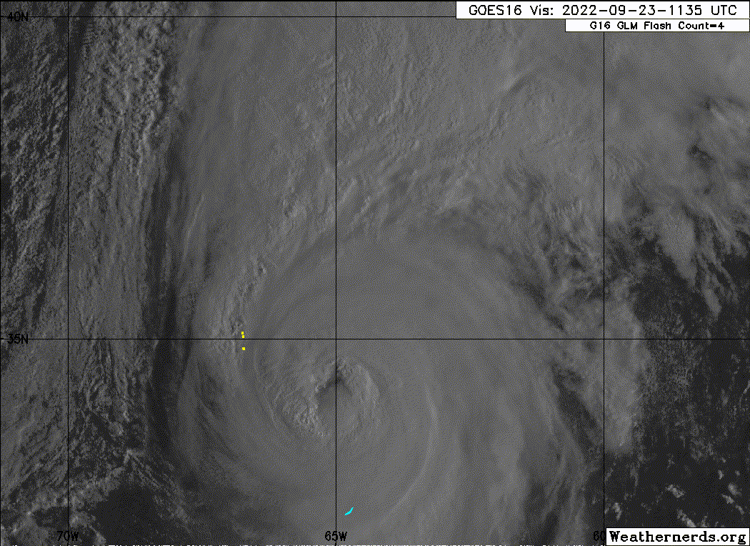
Recon is catching back up with Fiona for (presumably) one final pass through the SE quadrant.
0 likes
Irene '11 Sandy '12 Hermine '16 5/15/2018 Derecho Fay '20 Isaias '20 Elsa '21 Henri '21 Ida '21
I am only a meteorology enthusiast who knows a decent amount about tropical cyclones. Look to the professional mets, the NHC, or your local weather office for the best information.
I am only a meteorology enthusiast who knows a decent amount about tropical cyclones. Look to the professional mets, the NHC, or your local weather office for the best information.


Re: ATL: FIONA - Hurricane - Discussion
Fiona is looking extremely impressive considering her latitude. Unfortunately for Nova Scotia, I just don’t see how this doesn’t go down as one of the most significant impacts of the HURDAT era there. With baroclinic forcing we should have a full fledged extratropical cyclone by the time she hits land, but it may be a very close transition and I’d say there’s an outside chance we’re looking at a landfalling storm that’s still tropical. Ultimately though, it won’t matter for much other than statistics… the impacting surge and winds are going to be severe either way. I know this is a very US-centric forum, so we’re not really hearing much from those in the path of Fiona, but I truly hope they are preparing for a substantial impact and are taking all the necessary precautions.
4 likes
Re: ATL: FIONA - Hurricane - Discussion
Closely watching from Sackville NB. I don't think I'll be getting much sleep tonight. Also I'm not an expert and it's likely short term but looking at the sat images seems like she's running slightly off NHCs track to the right at the moment.
4 likes
My Storms:
Earl 2010, Arthur 2014, Dorian 2019, Teddy 2020 and Fiona 2022
Storms that had a major impact on my area are bolded.
Earl 2010, Arthur 2014, Dorian 2019, Teddy 2020 and Fiona 2022
Storms that had a major impact on my area are bolded.
-
cainjamin

- Tropical Storm

- Posts: 173
- Age: 34
- Joined: Mon Apr 17, 2017 1:38 pm
- Location: Nova Scotia, Canada
Re: ATL: FIONA - Hurricane - Discussion
Checking in from Nova Scotia - I'm about an hour to the northwest of Halifax. Expecting tropical storm force winds here but most likely not hurricane force - everything is tied down, we have our weekend supplies and bottle water just in case. The eastern shore of the province is thankfully very sparsely populated, but they are in for the storm of a lifetime down there. I have a few family and friends in Antigonish and Cheticamp so I'll post periodically letting you all know how we're making out.
10 likes
Noel '07, Kyle '08, Earl '10, Arthur '14, Dorian '19, Teddy '20, Lee '23
Who is online
Users browsing this forum: No registered users and 18 guests