
ATL: IAN - Post-Tropical - Discussion
Moderator: S2k Moderators
-
tolakram
- Admin

- Posts: 20186
- Age: 62
- Joined: Sun Aug 27, 2006 8:23 pm
- Location: Florence, KY (name is Mark)
Re: ATL: IAN - Tropical Storm - Discussion
Maybe this is the burst, but I've seen a few of these die out. We need more than one tower IMO.
10 likes
M a r k
- - - - -
Join us in chat: Storm2K Chatroom Invite. Android and IOS apps also available.
The posts in this forum are NOT official forecasts and should not be used as such. Posts are NOT endorsed by any professional institution or STORM2K.org. For official information and forecasts, please refer to NHC and NWS products.
-
dukeblue219
- S2K Supporter

- Posts: 556
- Joined: Fri Sep 30, 2016 3:52 pm
Re: ATL: IAN - Tropical Storm - Discussion
Hammy wrote:Hurricane intensity has been pushed back 24-30 hours over the last few advisory cycles and starting to run out of time
Not quite sure I'd agree with that... There is a ton of time left for this thing to become a hurricane.
3 likes
-
cycloneye

- Admin
- Posts: 149508
- Age: 69
- Joined: Thu Oct 10, 2002 10:54 am
- Location: San Juan, Puerto Rico
Re: ATL: IAN - Tropical Storm - Discussion
ObsessedMiami wrote:I don’t see the track shifted much at all this advisory.
The latest NHC track forecast has been adjusted in
this direction, but only on the order of 15-20 n mi in the extended
range.
this direction, but only on the order of 15-20 n mi in the extended
range.
1 likes
Visit the Caribbean-Central America Weather Thread where you can find at first post web cams,radars
and observations from Caribbean basin members Click Here
and observations from Caribbean basin members Click Here

Re: ATL: IAN - Tropical Storm - Discussion
dukeblue219 wrote:Hammy wrote:Hurricane intensity has been pushed back 24-30 hours over the last few advisory cycles and starting to run out of time
Not quite sure I'd agree with that... There is a ton of time left for this thing to become a hurricane.
It's going to have to ramp up soon to reach hurricane intensity before Cuba.
2 likes
The above post is not official and should not be used as such. It is the opinion of the poster and may or may not be backed by sound meteorological data. It is not endorsed by any professional institution or storm2k.org. For official information, please refer to the NHC and NWS products.
Re: ATL: IAN - Tropical Storm - Discussion
Hammy wrote:Hurricane intensity has been pushed back 24-30 hours over the last few advisory cycles and starting to run out of time. Either this is going to do what the season as a whole did continue to struggle, only to explode at the last minute, or we're going to see a major forecasting bust like we did with Debby in 2000 and Erika in 2015.
I'd say the chances are 50/50 in either direction at this point.
Meanwhile, the storm has done precisely what the Euro has predicted over the past several cycles. No intensification until approach to Cuba. The "bust" is on the GFS/HWRF
6 likes
-
tropicwatch

- Category 5

- Posts: 3426
- Age: 62
- Joined: Sat Jun 02, 2007 10:01 am
- Location: The Villages, Florida
- Contact:
Re: ATL: IAN - Tropical Storm - Discussion
ScottNAtlanta wrote:I guess recon flights are able to fly over Cuba now since the newest recon is doing just that.
Was about to mention that and will save time.
1 likes
Tropicwatch
Agnes 72', Eloise 75, Elena 85', Kate 85', Charley 86', Florence 88', Beryl 94', Dean 95', Erin 95', Opal 95', Earl 98', Georges 98', Ivan 2004', Arlene 2005', Dennis 2005', Ida 2009' Debby 2012' Irma 2017' Michael 2018'
Agnes 72', Eloise 75, Elena 85', Kate 85', Charley 86', Florence 88', Beryl 94', Dean 95', Erin 95', Opal 95', Earl 98', Georges 98', Ivan 2004', Arlene 2005', Dennis 2005', Ida 2009' Debby 2012' Irma 2017' Michael 2018'
-
islandgirl45
- Tropical Low

- Posts: 22
- Joined: Tue Oct 20, 2009 10:51 pm
Re: ATL: IAN - Tropical Storm - Discussion
wxman57 wrote:HurricaneBelle wrote:The new NHC track puts the eye of Ian about 50 miles to my west off the Pinellas coast at 28.3/84.0, albeit weakening to a Cat 2 (85 kt)
That point is 75 miles offshore. Consensus is about 30 miles offshore. NHC will be adjusting closer to you tonight. Be prepared for hurricane conditions Thursday.
If the NHC adjusts the 11pm track to roughly the location of where the TVCN is now, and given the NHC's current intensity forecast for Ian, would you generally expect coastal Volusia County (Daytona Beach and south) to experience tropical storm winds? Or something less?
1 likes

-
Jelmergraaff
- Tropical Storm

- Posts: 138
- Age: 23
- Joined: Fri Aug 27, 2021 1:00 pm
- Location: The Netherlands
Re: ATL: IAN - Tropical Storm - Discussion
tolakram wrote:Maybe this is the burst, but I've seen a few of these die out. We need more than one tower IMO.
https://i.imgur.com/qURQV2z.gif
I have not seen such a strong burst yet. This could well be what takes it into RI-stage.
3 likes
21-year old meteorologist and student MSc Climate Studies from The Netherlands. Interested in all fields of meteorology and climatology, including tropical systems like hurricanes.
-
USTropics
- Professional-Met

- Posts: 2739
- Joined: Sun Aug 12, 2007 3:45 am
- Location: Florida State University
Re: ATL: IAN - Tropical Storm - Discussion
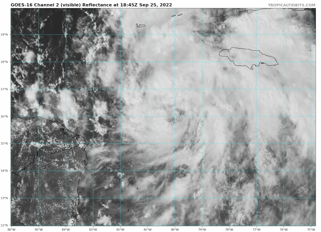
Some observations from today:
Mid-level circulation was slightly offset to the SE from the LLC earlier today, you can see this in the HWRF analysis. There is also some subtle dry air towards the western quadrant that is noticeable, and this has likely put a cap on convection in combination with d-min as the circulation has expanded (typical evolution of a developing system).

This was also observed in the CIMSS 700mb (mid-level) vort signature. Here is an animation that shows the MLC sort of lurching north in the past 3-6 hours. This has likely caused the more northward motion observed earlier today on satellite.

Compare this to the LLC, and the system is now more vertically stacked:

Convection will increase into the evening and overnight and we can start to see this now on satellite imagery. The latest signs of vertical hot towers is another indication the storm is becoming more vertically stacked, as this is a mechanism to tighten the circulation up so to speak. Expect some pulse up and pulse down phases as it continues to develop over night.

Mid-level circulation was slightly offset to the SE from the LLC earlier today, you can see this in the HWRF analysis. There is also some subtle dry air towards the western quadrant that is noticeable, and this has likely put a cap on convection in combination with d-min as the circulation has expanded (typical evolution of a developing system).
This was also observed in the CIMSS 700mb (mid-level) vort signature. Here is an animation that shows the MLC sort of lurching north in the past 3-6 hours. This has likely caused the more northward motion observed earlier today on satellite.
Compare this to the LLC, and the system is now more vertically stacked:
Convection will increase into the evening and overnight and we can start to see this now on satellite imagery. The latest signs of vertical hot towers is another indication the storm is becoming more vertically stacked, as this is a mechanism to tighten the circulation up so to speak. Expect some pulse up and pulse down phases as it continues to develop over night.
17 likes
-
StPeteMike

- Category 2

- Posts: 656
- Joined: Thu Jun 07, 2018 11:26 pm
Re: ATL: IAN - Tropical Storm - Discussion
Though I expected a steady increase of strength today and pretty much Ian wanted to just stay as is, tomorrow SHOULD be different. It looks like it’s trying to get its outflow set up to feed into it all day Monday, we will have to see if it stays together overnight.
5 likes
The above post is not official and should not be used as such. It is the opinion of the poster and may or may not be backed by sound meteorological data. It is not endorsed by any professional institution or storm2k.org. For official information, please refer to the NHC and NWS products.
Re: ATL: IAN - Tropical Storm - Discussion
The overall convective canopy seems to be thickening.
4 likes
-
StormPyrate
- Category 1

- Posts: 286
- Joined: Sun May 27, 2018 8:41 pm
- Location: Clearwater, FL
Re: ATL: IAN - Tropical Storm - Discussion
sponger wrote:That looked like a fairly substantial North jog on vis!
it was, as discussed on the 5PM NHC discussion
2 likes
St Petersburg Florida
-
eastcoastFL

- Category 5
- Posts: 3996
- Age: 44
- Joined: Thu Apr 12, 2007 12:29 pm
- Location: Palm City, FL
Re: ATL: IAN - Tropical Storm - Discussion
That northern jog put Ian to the right of everything for the moment. Let’s see if he gets back on course or if there’s some major shifts, I’d say the whole state is still in play for Florida.
2 likes
Personal Forecast Disclaimer:
The posts in this forum are NOT official forecast and should not be used as such. They are just the opinion of the poster and may or may not be backed by sound meteorological data. They are NOT endorsed by any professional institution or storm2k.org. For official information, please refer to the NHC and NWS products.
The posts in this forum are NOT official forecast and should not be used as such. They are just the opinion of the poster and may or may not be backed by sound meteorological data. They are NOT endorsed by any professional institution or storm2k.org. For official information, please refer to the NHC and NWS products.
-
eastcoastFL
- Category 5
- Posts: 3996
- Age: 44
- Joined: Thu Apr 12, 2007 12:29 pm
- Location: Palm City, FL
Re: ATL: IAN - Tropical Storm - Discussion
1 likes
Personal Forecast Disclaimer:
The posts in this forum are NOT official forecast and should not be used as such. They are just the opinion of the poster and may or may not be backed by sound meteorological data. They are NOT endorsed by any professional institution or storm2k.org. For official information, please refer to the NHC and NWS products.
The posts in this forum are NOT official forecast and should not be used as such. They are just the opinion of the poster and may or may not be backed by sound meteorological data. They are NOT endorsed by any professional institution or storm2k.org. For official information, please refer to the NHC and NWS products.

Re: ATL: IAN - Tropical Storm - Discussion
StormPyrate wrote:sponger wrote:That looked like a fairly substantial North jog on vis!
it was, as discussed on the 5PM NHC discussion
5 PM discussion track history:
"PRESENT MOVEMENT...WNW OR 300 DEGREES AT 12 MPH...19 KM/H"
That is the heading I get if I average the storm track 10 hours from sunrise to the convective burst near sunset.
NW is 315 degrees which recon may find in a few hours or we can calculate in the morning.
They have till 36 hours before landfall to shift the track but I'm not sure they will follow the TVCN this time.
1 likes
-
Iceresistance

- Category 5
- Posts: 9592
- Age: 22
- Joined: Sat Oct 10, 2020 9:45 am
- Location: Tecumseh, OK/Norman, OK
Re: ATL: IAN - Tropical Storm - Discussion
Recon is booking it towards Ian, bearing is at 377 knots (433.8 mph).
3 likes
Bill 2015 & Beta 2020
Winter 2020-2021
All observations are in Tecumseh, OK unless otherwise noted.
Winter posts are focused mainly for Oklahoma & Texas.
Take any of my forecasts with a grain of salt, refer to the NWS, SPC, and NHC for official information
Never say Never with weather! Because ANYTHING is possible!
Winter 2020-2021
All observations are in Tecumseh, OK unless otherwise noted.
Winter posts are focused mainly for Oklahoma & Texas.
Take any of my forecasts with a grain of salt, refer to the NWS, SPC, and NHC for official information
Never say Never with weather! Because ANYTHING is possible!
-
eastcoastFL
- Category 5
- Posts: 3996
- Age: 44
- Joined: Thu Apr 12, 2007 12:29 pm
- Location: Palm City, FL
Re: ATL: IAN - Tropical Storm - Discussion
Now this is kinda funny. My local NOAA forecast has had “tropical storm conditions possible” put up taken down and put back up twice today. Last time they were up for wed and wed night now it’s Wed night - thu night
Wednesday NightTropical storm conditions possible. Showers likely and possibly a thunderstorm. Mostly cloudy, with a low around 76. Chance of precipitation is 70%.
ThursdayTropical storm conditions possible. Showers likely and possibly a thunderstorm. Partly sunny, with a high near 88. Chance of precipitation is 70%.
Thursday NightTropical storm conditions possible. A 40 percent chance
1 likes
Personal Forecast Disclaimer:
The posts in this forum are NOT official forecast and should not be used as such. They are just the opinion of the poster and may or may not be backed by sound meteorological data. They are NOT endorsed by any professional institution or storm2k.org. For official information, please refer to the NHC and NWS products.
The posts in this forum are NOT official forecast and should not be used as such. They are just the opinion of the poster and may or may not be backed by sound meteorological data. They are NOT endorsed by any professional institution or storm2k.org. For official information, please refer to the NHC and NWS products.
-
ConvergenceZone
.gif)
- Category 5
- Posts: 5241
- Joined: Fri Jul 29, 2005 1:40 am
- Location: Northern California
Re: ATL: IAN - Tropical Storm - Discussion
tolakram wrote:Maybe this is the burst, but I've seen a few of these die out. We need more than one tower IMO.
https://i.imgur.com/qURQV2z.gif
That is definitely a really nice tower....Like you said, we'll see if this one is able to persist.
1 likes
-
HippyFarmGirl
- Tropical Wave

- Posts: 3
- Age: 55
- Joined: Wed Aug 17, 2022 7:17 am
Re: ATL: IAN - Tropical Storm - Discussion
wxman57 wrote: Consensus is about 30 miles offshore. NHC will be adjusting closer to you tonight. Be prepared for hurricane conditions Thursday.
wxman57 has your position changed with the latest round of data? Last I saw, you had said about 50 miles north of Tampa.
1 likes
The wall flower with a few South Florida storms under her belt.
Who is online
Users browsing this forum: No registered users and 48 guests