I'm sure most people know this but it doesn't hurt to repeat it. If you are going to leave...
Make sure you have all your important papers like insurance papers, deeds, anything that is important like photos. Put them in the gallon sized ziplock bags to keep them dry with you (you'll be taking those with you). Go around the house with your phone and photograph anything in case you have to file an insurance claim. Get serial numbers where appropriate. Make sure you have a full tank of gas and your phone is charged and you have a charger. Make sure you have medication you might need (and have a weeks worth or more if possible). If you are going to a shelter, bring pillows blankets or anything else you need to be more comfortable. If there are things I am forgetting please add on. I'm sure I am.
ATL: IAN - Post-Tropical - Discussion
Moderator: S2k Moderators
-
ScottNAtlanta

- Category 5

- Posts: 2535
- Joined: Sat May 25, 2013 3:11 pm
- Location: Atlanta, GA
Re: ATL: IAN - Tropical Storm - Discussion
Last edited by ScottNAtlanta on Sun Sep 25, 2022 9:55 pm, edited 1 time in total.
14 likes
The posts in this forum are NOT official forecast and should not be used as such. They are just the opinion of the poster and may or may not be backed by sound meteorological data. They are NOT endorsed by any professional institution or storm2k.org. For official information, please refer to the NHC and NWS products.
-
ElectricStorm

- Category 5
- Posts: 5147
- Age: 25
- Joined: Tue Aug 13, 2019 11:23 pm
- Location: Norman, OK
Re: ATL: IAN - Tropical Storm - Discussion
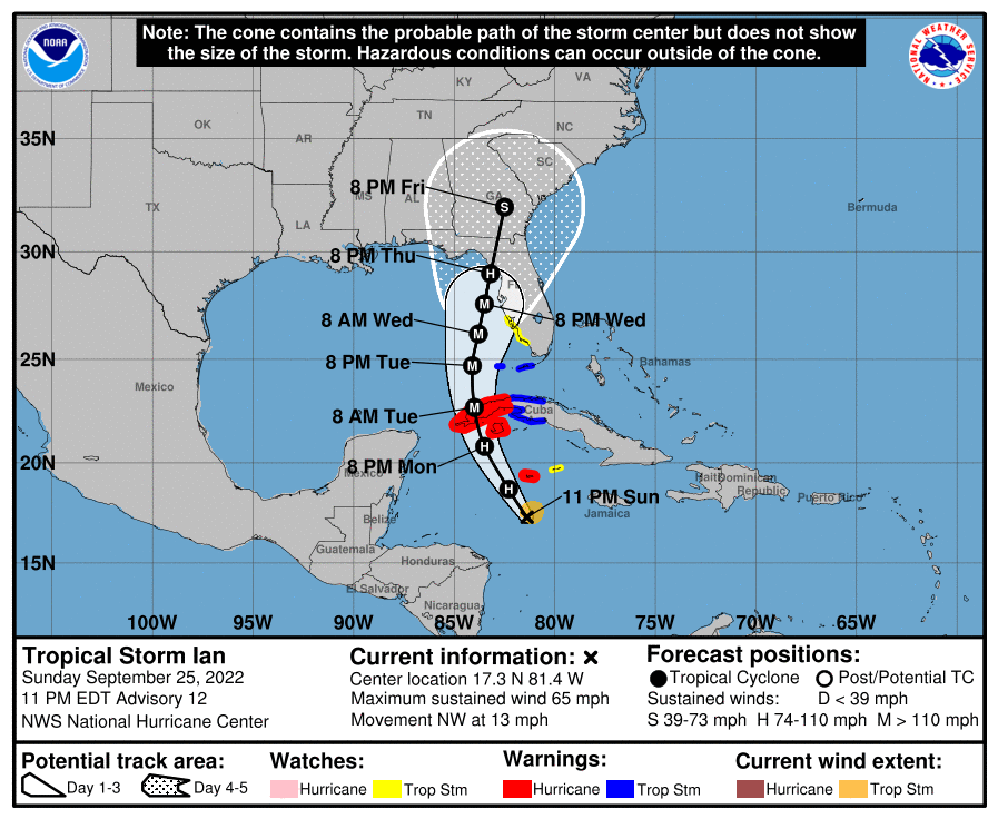
BULLETIN
Tropical Storm Ian Advisory Number 12
NWS National Hurricane Center Miami FL AL092022
1100 PM EDT Sun Sep 25 2022
...IAN CONTINUES TO STRENGTHEN...
...EXPECTED TO PRODUCE SIGNIFICANT WIND AND STORM SURGE IMPACTS
IN WESTERN CUBA...
SUMMARY OF 1100 PM EDT...0300 UTC...INFORMATION
-----------------------------------------------
LOCATION...17.3N 81.4W
ABOUT 140 MI...225 KM S OF GRAND CAYMAN
ABOUT 390 MI...630 KM SE OF THE WESTERN TIP OF CUBA
MAXIMUM SUSTAINED WINDS...65 MPH...100 KM/H
PRESENT MOVEMENT...NW OR 315 DEGREES AT 13 MPH...20 KM/H
MINIMUM CENTRAL PRESSURE...989 MB...29.21 INCHES
2 likes
B.S Meteorology, University of Oklahoma '25
Please refer to the NHC, NWS, or SPC for official information.
Please refer to the NHC, NWS, or SPC for official information.


Re: ATL: IAN - Tropical Storm - Discussion
A TROPICAL STORM WARNING HAS BEEN ISSUED FOR THE LOWER FLORIDA KEYS
FROM SEVEN MILE BRIDGE WESTWARD TO KEY WEST...INCLUDING THE DRY
TORTUGAS.
A STORM SURGE WATCH HAS BEEN ISSUED FOR THE FLORIDA KEYS FROM THE
CARD SOUND BRIDGE WESTWARD TO KEY WEST...INCLUDING THE DRY
TORTUGAS...AND FOR THE WEST COAST OF FLORIDA FROM ENGLEWOOD
SOUTHWARD TO THE CARD SOUND BRIDGE...INCLUDING FLORIDA BAY.
A TROPICAL STORM WATCH HAS BEEN ISSUED FOR THE WEST COAST OF
FLORIDA FROM ENGLEWOOD SOUTHWARD TO CHOKOLOSKEE.
Last edited by Owasso on Sun Sep 25, 2022 9:55 pm, edited 1 time in total.
1 likes
Re: ATL: IAN - Tropical Storm - Discussion
I'm thinking about tomorrow morning when people wake up for work and realize a rapid intensifying storm is on its way and what kind of panic the whole west coast of Florida is going to have. Hopefully they can get people out of harms way successfully. Gonna be a nightmare on 75 north.
5 likes
-
eastcoastFL

- Category 5
- Posts: 3996
- Age: 44
- Joined: Thu Apr 12, 2007 12:29 pm
- Location: Palm City, FL
Re: ATL: IAN - Tropical Storm - Discussion
Is there a cayman radar site or any others in range of Ian?
1 likes
Personal Forecast Disclaimer:
The posts in this forum are NOT official forecast and should not be used as such. They are just the opinion of the poster and may or may not be backed by sound meteorological data. They are NOT endorsed by any professional institution or storm2k.org. For official information, please refer to the NHC and NWS products.
The posts in this forum are NOT official forecast and should not be used as such. They are just the opinion of the poster and may or may not be backed by sound meteorological data. They are NOT endorsed by any professional institution or storm2k.org. For official information, please refer to the NHC and NWS products.
-
StPeteMike

- Category 2

- Posts: 656
- Joined: Thu Jun 07, 2018 11:26 pm
Re: ATL: IAN - Tropical Storm - Discussion
HurricaneBelle wrote:Pretty much have talked myself into leaving the Clearwater area - this time around it's just me I'm responsible for and I have so many large trees near the house that I'm not sure I want to play roulette with one (or more) of them possibly falling on me, especially with the potential for 12-15" of rain or more to soften up the ground combined with a possible 48-hour duration of at least tropical storm-force winds. And even if I get through that relatively unscathed I'm looking at days if not weeks without power or internet and perhaps even cell service. And it's not like I can do anything about it if I stay. Plus it's also a good excuse to visit my son in Tallahassee (even if one of those goofy GFS runs verified it'd be a tropical storm up there).
It's gonna stink to have to worry about the house while I'm gone but I know at least my car will be safe and so will I. Gonna head up 19 (wouldn't want to go anywhere near I-75) either later tomorrow or Tuesday morning after getting some stuff taken care of before I leave.
The family and I are going to ride it out. Hoping models like the Euro don’t come to truth as that puts us on the strongest side for a good while with the slowdown in forward speed.
Best to evacuate though!
2 likes
The above post is not official and should not be used as such. It is the opinion of the poster and may or may not be backed by sound meteorological data. It is not endorsed by any professional institution or storm2k.org. For official information, please refer to the NHC and NWS products.
Re: ATL: IAN - Tropical Storm - Discussion
eastcoastFL wrote:Is there a cayman radar site or any others in range of Ian?
https://www.weather.gov.ky/radar
Cayman Radar has Ian in range at 250 and 150 miles.
4 likes
Re: ATL: IAN - Tropical Storm - Discussion
skillz305 wrote:dpep4 wrote:Huh, so the next Sunday NIght Football game is scheduled to be KC at Tampa Bay....
We’ve seen games be postponed for Hurricanes before. We shall see how everything turns out.
If it hits Tampa hard they might relocate. Maybe even if it just gets close to Tampa, because of the logistics and need to drive in broadcast equipment ahead of time. Might be moved to KC, since there are games that day at many of the logical neutral emergency sites: New Orleans, Houston, Dallas, Indy, Atlanta, Detroit. Might use Chicago or Minneapolis, but I bet they use KC. Jax too close to the path if it impacts Tampa and Miami would have the equip access issues.
Playing right after a hurricane with major damage would be a logistical headache, and bad optics if resources were diverted to restore utilities to the stadium, etc. Could cancel/postpone to let the players deal with their families, but past history suggests they'll most likely to play Sun nite and in KC (if a major hit near Tampa).
Obviously a very unimportant thing compared to possible damage to homes and lives, but an interesting side topic.
Last edited by dpep4 on Sun Sep 25, 2022 10:58 pm, edited 1 time in total.
4 likes


Re: ATL: IAN - Tropical Storm - Discussion
Thoughts before the 11 pm forecast.
I'm in central St. Pete and will be riding it out here no matter what, because the house is at 55 feet elevation.
I have large oaks in the yard, but I believe the house would blow away before a live oak gets blown over. They are just incredibly deep rooted and the ground here is all sand.
Anyone in an evacuation zone in Tampa should definitely have a plan. Go just a little ways inland to friends or family if possible, you don't have to evacuate hundreds of miles.
Funny, but at this point Fort Lauderdale and Miami are going to be out of it. Sometimes in Florida evacuating south is actually a smart move.
Be safe everyone. Now, to see if the track has shifted even closer to me...
7 likes
Re: ATL: IAN - Tropical Storm - Discussion
caneman wrote:It was planned out thoroughly but you can't account for every variable that can take place. There is always an unknown element or no prior case study, etc..
This. Soooo much this.
A tangentially-related story I've always recalled from the 2016 Louisiana flooding, caused by basically a stationary 'inland hurricane' a la Harvey a year later, is of a retired hydrologist with an elevated home on pylons. After the floodwaters exited his house he complained to someone how he'd picked the location and elevation based on the fact it that what had just happened would be impossible. He had high water marks of past floods . . . the highest being the old local "big one" of 1983, like ten feet below his soggy floor.
So it goes.
6 likes
Baton Rouge area cyclone dilettante, PSWAGGER* tropical weather & hydrology model developer
(* Pseudo-Scientific Wild-A** Guesses Generally Expressed Ridiculously)
The GFDL would've had all this figured out by now.
(* Pseudo-Scientific Wild-A** Guesses Generally Expressed Ridiculously)
The GFDL would've had all this figured out by now.
-
ConvergenceZone
.gif)
- Category 5
- Posts: 5241
- Joined: Fri Jul 29, 2005 1:40 am
- Location: Northern California
Re: ATL: IAN - Tropical Storm - Discussion
Can someone post or link the full advisory when it comes out? I usually get it from wunderground.com but they are incredibly horrible at updating their maps and it still has the 5:00 PM discussion. I appreciate it.......
2 likes
Re: ATL: IAN - Tropical Storm - Discussion
I hope everyone knows their actual elevation and have bookmarked storm surge maps.
2 likes
Re: ATL: IAN - Tropical Storm - Discussion
Not just more east but maintains the Major longer just off of Tampa... this is a worst-case looking storm track
1 likes
// Opinions are my own, I am not a Meteorologist. Consult the NHC or Local NWS and Emergency Management for current information in your area. //
-
ElectricStorm
- Category 5
- Posts: 5147
- Age: 25
- Joined: Tue Aug 13, 2019 11:23 pm
- Location: Norman, OK
Re: ATL: IAN - Tropical Storm - Discussion
ConvergenceZone wrote:Can someone post or link the full advisory when it comes out? I usually get it from wunderground.com but they are incredibly horrible at updating their maps and it still has the 5:00 PM discussion. I appreciate it.......
It just updated
Tropical Storm Ian Discussion Number 12
NWS National Hurricane Center Miami FL AL092022
1100 PM EDT Sun Sep 25 2022
The storm has become better organized-looking on satellite imagery,
with strengthening central convection and developing banding
features. Upper-level anticyclonic outflow also appears to be
increasing over the system. Flight-level winds, Doppler radar
velocities, and dropsonde data from a NOAA Hurricane Hunter aircraft
indicate that Ian's intensity is now near 55 kt.
Ian has turned toward the northwest and the initial motion estimate
is now 315/11 kt. During the next 48 hours, the tropical cyclone
is expected to turn toward the north as it moves along the western
side of a mid-level high pressure area. Later in the forecast
period, a broad mid-tropospheric trough over the eastern United
States is likely to induce a slightly east of northward motion.
However, around 4 days, the steering currents are forecast to
weaken as the trough moves to the east of Ian's longitude. Some
of the guidance model tracks such as that from the GFS have, again,
shifted to the east, mainly after 48 hours. The official track
forecast has been shifted somewhat to the east of the previous one
and is mainly a blend of the latest ECMWF and GFS predictions. It
should again be stressed that there is still significant
uncertainty in the track of Ian, especially in the 3-5 day time
frame. Users should not focus on the details of the track forecast
at longer time ranges.
Observations from the aircraft indicate that the tropical cyclone
is developing an inner core, so significant intensification is
likely to occur during the next couple of days. The SHIPS Rapid
Intensification Index indicate a fairly high chance for rapid
strengthening during the next 24 to 36 hours, and the official
forecast reflects this likelihood, calling for Ian to become a
major hurricane over the southeastern Gulf of Mexico.
Key Messages:
1. Ian is expected to produce heavy rainfall and instances of
flash flooding and possible mudslides in areas of higher terrain,
particularly over Jamaica and Cuba. Considerable flooding impacts
are possible later this week in west central Florida. Additional
flash and urban flooding, and flooding on rivers across the Florida
Peninsula and parts of the Southeast cannot be ruled out for later
this week.
2. Life-threatening storm surge and hurricane-force winds are
expected in portions of western Cuba beginning late Monday, and Ian
is forecast to be at or near major hurricane strength when it is
near western Cuba. Efforts to protect life and property should be
rushed to completion.
3. Ian is expected to be a major hurricane in the eastern Gulf of
Mexico during the middle of this week, but uncertainty in the track
and intensity forecasts remains higher than usual. Regardless of
Ian’s exact track and intensity, there is a risk of dangerous storm
surge, hurricane-force winds, and heavy rainfall along the west
coast of Florida and the Florida Panhandle by the middle of this
week, and residents in Florida should ensure they have their
hurricane plan in place. Follow any advice given by local officials
and closely monitor updates to the forecast.
FORECAST POSITIONS AND MAX WINDS
INIT 26/0300Z 17.3N 81.4W 55 KT 65 MPH
12H 26/1200Z 18.7N 82.3W 65 KT 75 MPH
24H 27/0000Z 20.8N 83.5W 85 KT 100 MPH
36H 27/1200Z 22.7N 84.0W 100 KT 115 MPH
48H 28/0000Z 24.7N 84.1W 105 KT 120 MPH
60H 28/1200Z 26.2N 83.8W 115 KT 130 MPH
72H 29/0000Z 27.6N 83.5W 105 KT 120 MPH
96H 30/0000Z 29.0N 83.2W 80 KT 90 MPH
120H 01/0000Z 32.0N 82.5W 40 KT 45 MPH...INLAND
$$
Forecaster Pasch
4 likes
B.S Meteorology, University of Oklahoma '25
Please refer to the NHC, NWS, or SPC for official information.
Please refer to the NHC, NWS, or SPC for official information.
-
ConvergenceZone
- Category 5
- Posts: 5241
- Joined: Fri Jul 29, 2005 1:40 am
- Location: Northern California
Re: ATL: IAN - Tropical Storm - Discussion
Thanks ElectricStorm for posting the full advisory. I appreciate it.... Yea, looks like they bumped up the future winds. Also previously they had it at 80 MPH in 24 hours and now they have it at 100 MPH in 24 hours...
1 likes
-
floridasun
- Tropical Storm

- Posts: 245
- Joined: Tue Sep 14, 2021 3:59 pm
Re: ATL: IAN - Tropical Storm - Discussion
i saw this for south fl on this site wind to 57 mph in miami and south fl area https://www.weather.gov/srh/tropical?office=mfl#hti
3 likes
-
drewschmaltz
- S2K Supporter

- Posts: 351
- Joined: Thu Aug 27, 2015 8:19 pm
Re: ATL: IAN - Tropical Storm - Discussion
Recurve wrote:Thoughts before the 11 pm forecast.
I'm in central St. Pete and will be riding it out here no matter what, because the house is at 55 feet elevation.
I have large oaks in the yard, but I believe the house would blow away before a live oak gets blown over. They are just incredibly deep rooted and the ground here is all sand.
Anyone in an evacuation zone in Tampa should definitely have a plan. Go just a little ways inland to friends or family if possible, you don't have to evacuate hundreds of miles.
Funny, but at this point Fort Lauderdale and Miami are going to be out of it. Sometimes in Florida evacuating south is actually a smart move.
Be safe everyone. Now, to see if the track has shifted even closer to me...
I had huge 100 year old oaks fall over in my yard during Charlie in Orlando. Orlando has only ever seen category 1 winds (although we like to think we've seen the real deal - that's saved for coastal areas). My .02 is... if the eyewall of a Major is blowing on those trees, it's certainly possible to lose them. Especially with how wet the ground is.
1 likes
I HAVE ABSOLUTELY NO IDEA WHAT I'M TALKING ABOUT. PLEASE CONSULT SOMEONE WHO DOES. START WITH THE NHC. ALL POSTS ARE FOR ENTERTAINMENT PURPOSES ONLY.
-
Hypercane_Kyle

- Category 5
- Posts: 3465
- Joined: Sat Mar 07, 2015 7:58 pm
- Location: Cape Canaveral, FL
Re: ATL: IAN - Tropical Storm - Discussion
Looking at the NHC track, it's scary to note that the NHC is still west of the TVCN.
IMO, a lot of this is due to the storm's consistent east-of-track motion today. If this continues overnight, barring any significant deviations between tomorrow and landfall, Tampa could be in for a significant event.
IMO, a lot of this is due to the storm's consistent east-of-track motion today. If this continues overnight, barring any significant deviations between tomorrow and landfall, Tampa could be in for a significant event.
4 likes
My posts are my own personal opinion, defer to the National Hurricane Center (NHC) and other NOAA products for decision making during hurricane season.
Who is online
Users browsing this forum: No registered users and 13 guests