ATL: FIONA - Models

Moderator: S2k Moderators

Message
Author
User avatar
chaser1
S2K Supporter
S2K Supporter
Posts: 5464
Age: 64
Joined: Sat Oct 15, 2005 5:59 pm
Location: Longwood, Fl

Re: ATL: FIONA - Models

#201 Postby chaser1 » Thu Sep 15, 2022 10:30 am

CFLHurricane wrote:I don’t buy the sudden turn north next Tuesday the GFS, NAVGEM, and ICON are showing. I agree OTS is the likeliest outcome but the turn is just too tidy a solution.


I tend to agree for the following reason. If we were to take the Fiona's vertical structural integrity as a "status quo", and then magically place the storm just north of P.R. or the Rock, then sure it would likely begin to recurve. On the other hand though, if one were to project near-term weakening due to less favorable conditions exacerbated by GA land interaction then it would seem less reasonable that a vigorous MLC would still exist. A far more shallow system or even a remnant sharp wave would likely continue to progress generally towards the west or WNW. The EURO ensembles that SFLcane posted about an hour ago clearly shows members with stronger solutions recurving around 70-75W. The faster and weaker members depict a weaker and distinctly more westward track. I think Fiona will have weakened to a TW or even an open wave before reaching Puerto Rico's longitude. Further interaction with "the Rock" would then seem to prevent any opportunity for re-development at that time. That would suggest continued motion with the overall lower level flow at least unless regeneration a little further west were to then occur.
0 likes   
Andy D

(For official information, please refer to the NHC and NWS products.)

tolakram
Admin
Admin
Posts: 20009
Age: 62
Joined: Sun Aug 27, 2006 8:23 pm
Location: Florence, KY (name is Mark)

Re: ATL: FIONA - Models

#202 Postby tolakram » Thu Sep 15, 2022 10:48 am

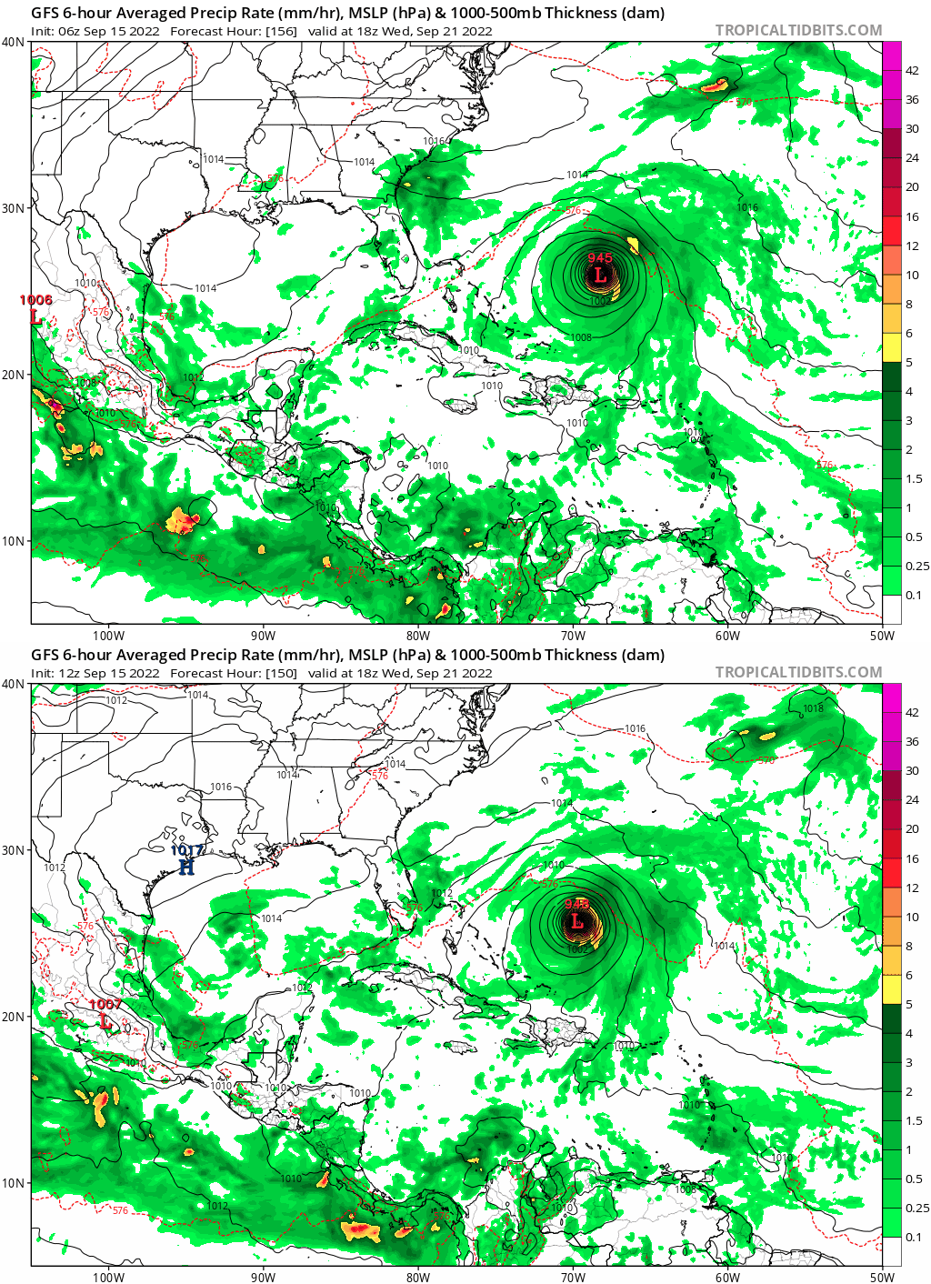
GFS 12Z running

Image
0 likes   
M a r k
- - - - -
Join us in chat: Storm2K Chatroom Invite. Android and IOS apps also available.

The posts in this forum are NOT official forecasts and should not be used as such. Posts are NOT endorsed by any professional institution or STORM2K.org. For official information and forecasts, please refer to NHC and NWS products.

User avatar
Iceresistance
Category 5
Category 5
Posts: 9288
Age: 21
Joined: Sat Oct 10, 2020 9:45 am
Location: Tecumseh, OK/Norman, OK

Re: ATL: FIONA - Models

#203 Postby Iceresistance » Thu Sep 15, 2022 10:55 am

tolakram wrote:GFS 12Z running

https://i.imgur.com/3jCOPhU.png


It's already even faster with Fiona than the 6z run.
0 likes   
Bill 2015 & Beta 2020

Winter 2020-2021 :cold:

All observations are in Tecumseh, OK unless otherwise noted.

Winter posts are focused mainly for Oklahoma & Texas.

Take any of my forecasts with a grain of salt, refer to the NWS, SPC, and NHC for official information

Never say Never with weather! Because ANYTHING is possible!

User avatar
chaser1
S2K Supporter
S2K Supporter
Posts: 5464
Age: 64
Joined: Sat Oct 15, 2005 5:59 pm
Location: Longwood, Fl

Re: ATL: FIONA - Models

#204 Postby chaser1 » Thu Sep 15, 2022 10:55 am

AutoPenalti wrote:
NDG wrote:Close up look of the 06z Euro run.

https://i.imgur.com/GQOfH3v.gif

That has to be a center reformation on the Euro, there's no way it does an immediate sharp turn like that.


Yup, if 65W - 70W is where more fertile conditions might exist then any center reformation, reincarnation, or sudden deepening would suggest at least some gain in latitude to then occur (unless forecast timing or values of S.E. CONUS mid level troughing were to not fully verify).
0 likes   
Andy D

(For official information, please refer to the NHC and NWS products.)

tolakram
Admin
Admin
Posts: 20009
Age: 62
Joined: Sun Aug 27, 2006 8:23 pm
Location: Florence, KY (name is Mark)

Re: ATL: FIONA - Models

#205 Postby tolakram » Thu Sep 15, 2022 10:56 am

Image
0 likes   
M a r k
- - - - -
Join us in chat: Storm2K Chatroom Invite. Android and IOS apps also available.

The posts in this forum are NOT official forecasts and should not be used as such. Posts are NOT endorsed by any professional institution or STORM2K.org. For official information and forecasts, please refer to NHC and NWS products.

tolakram
Admin
Admin
Posts: 20009
Age: 62
Joined: Sun Aug 27, 2006 8:23 pm
Location: Florence, KY (name is Mark)

Re: ATL: FIONA - Models

#206 Postby tolakram » Thu Sep 15, 2022 10:59 am

Image
0 likes   
M a r k
- - - - -
Join us in chat: Storm2K Chatroom Invite. Android and IOS apps also available.

The posts in this forum are NOT official forecasts and should not be used as such. Posts are NOT endorsed by any professional institution or STORM2K.org. For official information and forecasts, please refer to NHC and NWS products.

tolakram
Admin
Admin
Posts: 20009
Age: 62
Joined: Sun Aug 27, 2006 8:23 pm
Location: Florence, KY (name is Mark)

Re: ATL: FIONA - Models

#207 Postby tolakram » Thu Sep 15, 2022 11:00 am

GFS trend
Image
0 likes   
M a r k
- - - - -
Join us in chat: Storm2K Chatroom Invite. Android and IOS apps also available.

The posts in this forum are NOT official forecasts and should not be used as such. Posts are NOT endorsed by any professional institution or STORM2K.org. For official information and forecasts, please refer to NHC and NWS products.

User avatar
Iceresistance
Category 5
Category 5
Posts: 9288
Age: 21
Joined: Sat Oct 10, 2020 9:45 am
Location: Tecumseh, OK/Norman, OK

Re: ATL: FIONA - Models

#208 Postby Iceresistance » Thu Sep 15, 2022 11:01 am

GFS has a Puerto Rico landfall 84 hours out, it has trended SW compared to the previous runs.
0 likes   
Bill 2015 & Beta 2020

Winter 2020-2021 :cold:

All observations are in Tecumseh, OK unless otherwise noted.

Winter posts are focused mainly for Oklahoma & Texas.

Take any of my forecasts with a grain of salt, refer to the NWS, SPC, and NHC for official information

Never say Never with weather! Because ANYTHING is possible!

tolakram
Admin
Admin
Posts: 20009
Age: 62
Joined: Sun Aug 27, 2006 8:23 pm
Location: Florence, KY (name is Mark)

Re: ATL: FIONA - Models

#209 Postby tolakram » Thu Sep 15, 2022 11:02 am

Image
0 likes   
M a r k
- - - - -
Join us in chat: Storm2K Chatroom Invite. Android and IOS apps also available.

The posts in this forum are NOT official forecasts and should not be used as such. Posts are NOT endorsed by any professional institution or STORM2K.org. For official information and forecasts, please refer to NHC and NWS products.

User avatar
aspen
Category 5
Category 5
Posts: 8818
Joined: Sat Oct 12, 2019 7:10 pm
Location: Connecticut, USA

Re: ATL: FIONA - Models

#210 Postby aspen » Thu Sep 15, 2022 11:02 am

ICON still recurves Fiona on the east side of PR, and it becomes a Cat 4 north of the islands.
0 likes   
Irene '11 Sandy '12 Hermine '16 5/15/2018 Derecho Fay '20 Isaias '20 Elsa '21 Henri '21 Ida '21

I am only a meteorology enthusiast who knows a decent amount about tropical cyclones. Look to the professional mets, the NHC, or your local weather office for the best information.

tolakram
Admin
Admin
Posts: 20009
Age: 62
Joined: Sun Aug 27, 2006 8:23 pm
Location: Florence, KY (name is Mark)

Re: ATL: FIONA - Models

#211 Postby tolakram » Thu Sep 15, 2022 11:05 am

12Z ICON
Image
0 likes   
M a r k
- - - - -
Join us in chat: Storm2K Chatroom Invite. Android and IOS apps also available.

The posts in this forum are NOT official forecasts and should not be used as such. Posts are NOT endorsed by any professional institution or STORM2K.org. For official information and forecasts, please refer to NHC and NWS products.

User avatar
cycloneye
Admin
Admin
Posts: 145292
Age: 68
Joined: Thu Oct 10, 2002 10:54 am
Location: San Juan, Puerto Rico

Re: ATL: FIONA - Models

#212 Postby cycloneye » Thu Sep 15, 2022 11:05 am

12z GFS over me.

Image
0 likes   
Visit the Caribbean-Central America Weather Thread where you can find at first post web cams,radars
and observations from Caribbean basin members Click Here

User avatar
NDG
S2K Supporter
S2K Supporter
Posts: 15446
Joined: Sun Jul 09, 2006 10:14 pm
Location: Orlando, FL

Re: ATL: FIONA - Models

#213 Postby NDG » Thu Sep 15, 2022 11:06 am

Both latest 12z GFS and 06z Euro show improving UL conditions when it gets to the Leeward Islands, the reason why both models show Fiona starting the intensification process by then.

Image
Image
Last edited by NDG on Thu Sep 15, 2022 11:08 am, edited 1 time in total.
0 likes   

User avatar
Iceresistance
Category 5
Category 5
Posts: 9288
Age: 21
Joined: Sat Oct 10, 2020 9:45 am
Location: Tecumseh, OK/Norman, OK

Re: ATL: FIONA - Models

#214 Postby Iceresistance » Thu Sep 15, 2022 11:07 am

12z CMC is through the shredder. (Hispaniola)
0 likes   
Bill 2015 & Beta 2020

Winter 2020-2021 :cold:

All observations are in Tecumseh, OK unless otherwise noted.

Winter posts are focused mainly for Oklahoma & Texas.

Take any of my forecasts with a grain of salt, refer to the NWS, SPC, and NHC for official information

Never say Never with weather! Because ANYTHING is possible!

tolakram
Admin
Admin
Posts: 20009
Age: 62
Joined: Sun Aug 27, 2006 8:23 pm
Location: Florence, KY (name is Mark)

Re: ATL: FIONA - Models

#215 Postby tolakram » Thu Sep 15, 2022 11:13 am

Image
1 likes   
M a r k
- - - - -
Join us in chat: Storm2K Chatroom Invite. Android and IOS apps also available.

The posts in this forum are NOT official forecasts and should not be used as such. Posts are NOT endorsed by any professional institution or STORM2K.org. For official information and forecasts, please refer to NHC and NWS products.

tolakram
Admin
Admin
Posts: 20009
Age: 62
Joined: Sun Aug 27, 2006 8:23 pm
Location: Florence, KY (name is Mark)

Re: ATL: FIONA - Models

#216 Postby tolakram » Thu Sep 15, 2022 11:14 am

CMC weak but now moving it NW sooner.

Image
1 likes   
M a r k
- - - - -
Join us in chat: Storm2K Chatroom Invite. Android and IOS apps also available.

The posts in this forum are NOT official forecasts and should not be used as such. Posts are NOT endorsed by any professional institution or STORM2K.org. For official information and forecasts, please refer to NHC and NWS products.

AutoPenalti
Category 5
Category 5
Posts: 4030
Age: 29
Joined: Mon Aug 17, 2015 4:16 pm
Location: Ft. Lauderdale, Florida

Re: ATL: FIONA - Models

#217 Postby AutoPenalti » Thu Sep 15, 2022 11:16 am

GFS no florida threat this run. Avenue opens up.
Image
0 likes   
The posts in this forum are NOT official forecasts and should not be used as such. They are just the opinion of the poster and may or may not be backed by sound meteorological data. They are NOT endorsed by any professional institution or STORM2K. For official information, please refer to products from the NHC and NWS.


Model Runs Cheat Sheet:
GFS (5:30 AM/PM, 11:30 AM/PM)
HWRF, GFDL, UKMET, NAVGEM (6:30-8:00 AM/PM, 12:30-2:00 AM/PM)
ECMWF (1:45 AM/PM)

TCVN
is a weighted averaged

User avatar
SFLcane
S2K Supporter
S2K Supporter
Posts: 10163
Age: 47
Joined: Sat Jun 05, 2010 1:44 pm
Location: Lake Worth Florida

Re: ATL: FIONA - Models

#218 Postby SFLcane » Thu Sep 15, 2022 11:18 am

Image
1 likes   

LarryWx
S2K Supporter
S2K Supporter
Posts: 6302
Joined: Sun Sep 07, 2003 2:04 pm
Location: GA

Re: ATL: FIONA - Models

#219 Postby LarryWx » Thu Sep 15, 2022 11:19 am

12Z UKMET
MET OFFICE TROPICAL CYCLONE GUIDANCE FOR NORTH-EAST PACIFIC AND ATLANTIC

GLOBAL MODEL DATA TIME 1200UTC 15.09.2022

TROPICAL STORM FIONA ANALYSED POSITION : 16.3N 53.7W

ATCF IDENTIFIER : AL072022

LEAD CENTRAL MAXIMUM WIND
VERIFYING TIME TIME POSITION PRESSURE (MB) SPEED (KNOTS)
-------------- ---- -------- ------------- -------------
1200UTC 15.09.2022 0 16.3N 53.7W 1008 39
0000UTC 16.09.2022 12 16.5N 56.3W 1007 40
1200UTC 16.09.2022 24 16.7N 58.9W 1007 37
0000UTC 17.09.2022 36 17.0N 61.4W 1006 32
1200UTC 17.09.2022 48 17.4N 63.5W 1006 34
0000UTC 18.09.2022 60 18.1N 65.4W 1005 36
1200UTC 18.09.2022 72 17.8N 67.5W 1004 43
0000UTC 19.09.2022 84 19.2N 68.9W 1001 43
1200UTC 19.09.2022 96 19.9N 69.8W 997 56
0000UTC 20.09.2022 108 20.7N 71.2W 994 54
1200UTC 20.09.2022 120 21.3N 72.0W 996 51
0000UTC 21.09.2022 132 22.0N 72.2W 993 47
1200UTC 21.09.2022 144 23.1N 72.2W 990 48
0 likes   
Personal Forecast Disclaimer:
The posts in this forum are NOT official forecasts and should not be used as such. They are just the opinion of the poster and may or may not be backed by sound meteorological data. They are NOT endorsed by any professional institution or storm2k.org. For official information, please refer to the NHC and NWS products.

User avatar
Blown Away
S2K Supporter
S2K Supporter
Posts: 10145
Joined: Wed May 26, 2004 6:17 am

Re: ATL: FIONA - Models

#220 Postby Blown Away » Thu Sep 15, 2022 11:20 am

cycloneye wrote:12z GFS over me.

https://i.imgur.com/SomrbyO.gif


Yeah, PR could end up with a hurricane.
0 likes   
Hurricane Eye Experience: David 79, Irene 99, Frances 04, Jeanne 04, Wilma 05... EYE COMING MY WAY IN 2024…
Hurricane Brush Experience: Andrew 92, Erin 95, Floyd 99, Matthew 16, Irma 17, Ian 22, Nicole 22…


Return to “2022”

Who is online

Users browsing this forum: No registered users and 19 guests