ATL: NICOLE - Post-Tropical - Discussion
Moderator: S2k Moderators
-
eastcoastFL

- Category 5

- Posts: 3996
- Age: 44
- Joined: Thu Apr 12, 2007 12:29 pm
- Location: Palm City, FL
Re: ATL: NICOLE - Subtropical Storm - Discussion
0 likes
Personal Forecast Disclaimer:
The posts in this forum are NOT official forecast and should not be used as such. They are just the opinion of the poster and may or may not be backed by sound meteorological data. They are NOT endorsed by any professional institution or storm2k.org. For official information, please refer to the NHC and NWS products.
The posts in this forum are NOT official forecast and should not be used as such. They are just the opinion of the poster and may or may not be backed by sound meteorological data. They are NOT endorsed by any professional institution or storm2k.org. For official information, please refer to the NHC and NWS products.
-
cycloneye

- Admin

- Posts: 149517
- Age: 69
- Joined: Thu Oct 10, 2002 10:54 am
- Location: San Juan, Puerto Rico
Re: ATL: NICOLE - Subtropical Storm - Discussion
Michele B wrote:cane5 wrote:cycloneye wrote:https://i.imgur.com/4DdYvao.png
While there seems to be confidence that intensification is likely as it reaches the bahamas there seems to be less confidence in where Nicole makes landfall. It would be a good time at some point today to check the ICON model since it’s my opinion it is very accurate on where Nicole will make landfall.
Yes, please someone explain where to find the ICON model as I think I’m trusting it more than most at this point. Not to say I won’t look at others, but I’m just doing my own little “science experiment” with it, if you will.
https://www.tropicaltidbits.com/analysi ... 10706&fh=6
1 likes
Visit the Caribbean-Central America Weather Thread where you can find at first post web cams,radars
and observations from Caribbean basin members Click Here
and observations from Caribbean basin members Click Here
-
eastcoastFL
- Category 5
- Posts: 3996
- Age: 44
- Joined: Thu Apr 12, 2007 12:29 pm
- Location: Palm City, FL
Re: ATL: NICOLE - Subtropical Storm - Discussion
GCANE wrote:Nicole is located between the northern edge of the cutoff UL Low and the bottom of the UL trough.
This places Nicole in a minimum 355K PV.
Of all the places to be, this is the best spot for intensification.
I’m seeing 25-30 kts of shear and an abundance of dry air over Florida and the western Bahamas. Will this inhibit strengthening as it approaches the peninsula or do we expect the area to become more conducive on approach?
0 likes
Personal Forecast Disclaimer:
The posts in this forum are NOT official forecast and should not be used as such. They are just the opinion of the poster and may or may not be backed by sound meteorological data. They are NOT endorsed by any professional institution or storm2k.org. For official information, please refer to the NHC and NWS products.
The posts in this forum are NOT official forecast and should not be used as such. They are just the opinion of the poster and may or may not be backed by sound meteorological data. They are NOT endorsed by any professional institution or storm2k.org. For official information, please refer to the NHC and NWS products.
-
cycloneye
- Admin
- Posts: 149517
- Age: 69
- Joined: Thu Oct 10, 2002 10:54 am
- Location: San Juan, Puerto Rico
Re: ATL: NICOLE - Subtropical Storm - Discussion
0 likes
Visit the Caribbean-Central America Weather Thread where you can find at first post web cams,radars
and observations from Caribbean basin members Click Here
and observations from Caribbean basin members Click Here

Re: ATL: NICOLE - Subtropical Storm - Discussion
Watching models carefully on the interaction of a low developing over the Great Lakes end of the week and Nicole running up the coast.
Phasing of the two would be a very bad thing.
Phasing of the two would be a very bad thing.
1 likes
Re: ATL: NICOLE - Subtropical Storm - Discussion
eastcoastFL wrote:GCANE wrote:Nicole is located between the northern edge of the cutoff UL Low and the bottom of the UL trough.
This places Nicole in a minimum 355K PV.
Of all the places to be, this is the best spot for intensification.
I’m seeing 25-30 kts of shear and an abundance of dry air over Florida and the western Bahamas. Will this inhibit strengthening as it approaches the peninsula or do we expect the area to become more conducive on approach?
On the 10th, models have 20+ knts of shear
https://rammb-data.cira.colostate.edu/t ... 061800.png
Of course, that inhibits intensification of a TC. Also, no really solid anti-cyclone is forecast to be over Nicole on approach.
However, it'll be in the Gulf Stream and any large towers that may fire would kick shear out of the way.
A more higher shear environment would lead to a higher chance of tornadoes.
A particularly important point is that GFS is forecasting Nicole entraining high CAPE air on approach with the NW flank being particularly vulnerable for tornadoes.
TS's and STS's many times can be tornado generators.
1 likes
-
toad strangler

- S2K Supporter

- Posts: 4546
- Joined: Sun Jul 28, 2013 3:09 pm
- Location: Earth
- Contact:
-
cycloneye
- Admin
- Posts: 149517
- Age: 69
- Joined: Thu Oct 10, 2002 10:54 am
- Location: San Juan, Puerto Rico
Re: ATL: NICOLE - Subtropical Storm - Discussion
0 likes
Visit the Caribbean-Central America Weather Thread where you can find at first post web cams,radars
and observations from Caribbean basin members Click Here
and observations from Caribbean basin members Click Here
-
cycloneye
- Admin
- Posts: 149517
- Age: 69
- Joined: Thu Oct 10, 2002 10:54 am
- Location: San Juan, Puerto Rico
Re: ATL: NICOLE - Subtropical Storm - Discussion
12z Best Track:
https://ftp.nhc.noaa.gov/atcf/btk/bal172022.dat

AL, 17, 2022110712, , BEST, 0, 259N, 691W, 40, 1002, SS
https://ftp.nhc.noaa.gov/atcf/btk/bal172022.dat
3 likes
Visit the Caribbean-Central America Weather Thread where you can find at first post web cams,radars
and observations from Caribbean basin members Click Here
and observations from Caribbean basin members Click Here
-
Coolcruiseman
- Tropical Depression

- Posts: 97
- Age: 52
- Joined: Wed Sep 21, 2022 8:10 pm
- Location: Melbourne, FL
Re: ATL: NICOLE - Subtropical Storm - Discussion
NDG wrote:The biggest impacts whether Nicole becomes a hurricane or not will be north of the center of Nicole, widespread 20'+ foot waves will be a big problem for many coastal communities especially in Volusia County.
https://i.imgur.com/lTpkczA.png
That has been highlighted for the last few days for Brevard County as well by NWS Melbourne.
1 likes
-
Blown Away

- S2K Supporter
- Posts: 10253
- Joined: Wed May 26, 2004 6:17 am
Re: ATL: NICOLE - Subtropical Storm - Discussion
Looks like an NW to SE elongated COC…
0 likes
Hurricane Eye Experience: David 79, Irene 99, Frances 04, Jeanne 04, Wilma 05… Hurricane Brush Experience: Andrew 92, Erin 95, Floyd 99, Matthew 16, Irma 17, Ian 22, Nicole 22…

Re: ATL: NICOLE - Subtropical Storm - Discussion
eastcoastFL wrote:GCANE wrote:Nicole is located between the northern edge of the cutoff UL Low and the bottom of the UL trough.
This places Nicole in a minimum 355K PV.
Of all the places to be, this is the best spot for intensification.
I’m seeing 25-30 kts of shear and an abundance of dry air over Florida and the western Bahamas. Will this inhibit strengthening as it approaches the peninsula or do we expect the area to become more conducive on approach?
Models are persistent in that it will become more conducive for strengthening over the NW Bahamas into southern FL.
0 likes
-
HurricaneBelle

- S2K Supporter
- Posts: 1209
- Joined: Sun Aug 27, 2006 6:12 pm
- Location: Clearwater, FL
Re: ATL: NICOLE - Subtropical Storm - Discussion
Definitely becoming more of a concern on the west coast - I was without power for two days in Pinellas away from the coast despite Ian only sideswiping us. NHC's wind probabilities have Tampa at 43% for TS winds, the highest for any non-East coast location.
3 likes
Re: ATL: NICOLE - Subtropical Storm - Discussion
Lots of overshooting tops bubbling away right where recon tags it at 25.92N 69.13W
Looks like it found its sweet spot between the UL cutoff low and UL trough.
Looks like it found its sweet spot between the UL cutoff low and UL trough.
0 likes
-
cycloneye
- Admin
- Posts: 149517
- Age: 69
- Joined: Thu Oct 10, 2002 10:54 am
- Location: San Juan, Puerto Rico
Re: ATL: NICOLE - Subtropical Storm - Discussion
1 likes
Visit the Caribbean-Central America Weather Thread where you can find at first post web cams,radars
and observations from Caribbean basin members Click Here
and observations from Caribbean basin members Click Here

Re: ATL: NICOLE - Subtropical Storm - Discussion
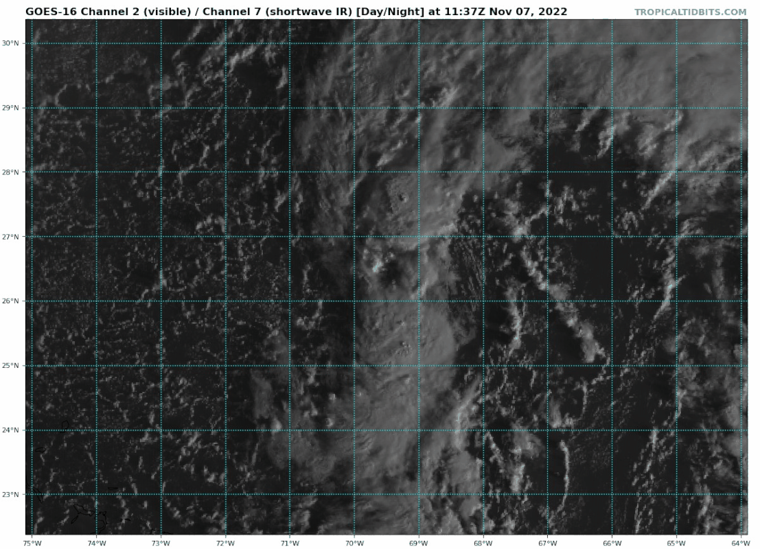
Blown Away wrote:[url]https://i.postimg.cc/Px9wWzbF/goes16-vis-swir-17-L-202211071137.gif [/url]
Looks like an NW to SE elongated COC…
Maybe NHC will answer my question from earlier about a southern warm core center at 11AM.
0 likes
-
cycloneye
- Admin
- Posts: 149517
- Age: 69
- Joined: Thu Oct 10, 2002 10:54 am
- Location: San Juan, Puerto Rico
Re: ATL: NICOLE - Subtropical Storm - Discussion
0 likes
Visit the Caribbean-Central America Weather Thread where you can find at first post web cams,radars
and observations from Caribbean basin members Click Here
and observations from Caribbean basin members Click Here
Re: ATL: NICOLE - Subtropical Storm - Discussion
Latest GFS shows an extreme, off-the-scale, large area of vorticity on approach to the east FL coast.
Area north of the CoC maybe particularly vulnerable to tornadoes due to frictional effects of the land (boundary layer) to the north quad's winds.
Area north of the CoC maybe particularly vulnerable to tornadoes due to frictional effects of the land (boundary layer) to the north quad's winds.
0 likes
-
skillz305
- Category 1

- Posts: 312
- Joined: Sat Sep 08, 2018 11:10 am
- Location: Miami, Florida --> Vero Beach, Florida
Re: ATL: NICOLE - Subtropical Storm - Discussion
Vero Beach, FL here. Work (boat production) hasn’t said a peep about this storm. Waiting to see if we have to work Wednesday or Thursday (usually off Fridays since we work 10 hour days). So much confusion at work as of now. But it’s coming, right? Even if a moderate TS.
0 likes
 Hurricanes: Andrew 1992 - Irene 1999 - Frances 2004 - Jeanne 2004 - Katrina 2005 - Wilma 2005 - Matthew 2016 - Irma 2017 - Ian 2022 - Nicole 2022 - Milton 2024
Re: ATL: NICOLE - Subtropical Storm - Discussion
skillz305 wrote:Vero Beach, FL here. Work (boat production) hasn’t said a peep about this storm. Waiting to see if we have to work Wednesday or Thursday (usually off Fridays since we work 10 hour days). So much confusion at work as of now. But it’s coming, right? Even if a moderate TS.
They may send u hm early but if it’s not a hurricane you probably will still hv to come in depending on how bad it is. if u lose electricity then i’m sure ur going to be sent home
0 likes
Robbielyn McCrary
I know just about enough to sound like I know what I'm talking about sometimes. But for your safety please follow the nhc for truly professional forecasting.
I know just about enough to sound like I know what I'm talking about sometimes. But for your safety please follow the nhc for truly professional forecasting.
Who is online
Users browsing this forum: No registered users and 19 guests