
ATL: NICOLE - Models
Moderator: S2k Moderators
-
tolakram
- Admin

- Posts: 20176
- Age: 62
- Joined: Sun Aug 27, 2006 8:23 pm
- Location: Florence, KY (name is Mark)
Re: ATL: NICOLE - Models
18Z Euro running
1 likes
M a r k
- - - - -
Join us in chat: Storm2K Chatroom Invite. Android and IOS apps also available.
The posts in this forum are NOT official forecasts and should not be used as such. Posts are NOT endorsed by any professional institution or STORM2K.org. For official information and forecasts, please refer to NHC and NWS products.

Re: ATL: NICOLE - Models
eastcoastFL wrote:Blown Away wrote:[url]https://i.postimg.cc/fRmSzfHT/hwrf-mslp-wind-17-L-fh0-93.gif [/url]
18z HWRF… 88 mph at landfall near WPB…
That would put me right in the northern eye wall. The late night runs will be interesting, I wonder how much the models change when this thing makes it’s transition to tropical. Or if they change at all?
I agree your whistling in the dark until we get a closed circulation and it has made that Southwest turn. We will know a lot more tommorrow but that’s the fun of this we don’t know everything….yet
0 likes
-
tolakram
- Admin
- Posts: 20176
- Age: 62
- Joined: Sun Aug 27, 2006 8:23 pm
- Location: Florence, KY (name is Mark)
Re: ATL: NICOLE - Models
Euro humidity

0 likes
M a r k
- - - - -
Join us in chat: Storm2K Chatroom Invite. Android and IOS apps also available.
The posts in this forum are NOT official forecasts and should not be used as such. Posts are NOT endorsed by any professional institution or STORM2K.org. For official information and forecasts, please refer to NHC and NWS products.
- - - - -
Join us in chat: Storm2K Chatroom Invite. Android and IOS apps also available.
The posts in this forum are NOT official forecasts and should not be used as such. Posts are NOT endorsed by any professional institution or STORM2K.org. For official information and forecasts, please refer to NHC and NWS products.
-
tolakram
- Admin
- Posts: 20176
- Age: 62
- Joined: Sun Aug 27, 2006 8:23 pm
- Location: Florence, KY (name is Mark)
Re: ATL: NICOLE - Models

0 likes
M a r k
- - - - -
Join us in chat: Storm2K Chatroom Invite. Android and IOS apps also available.
The posts in this forum are NOT official forecasts and should not be used as such. Posts are NOT endorsed by any professional institution or STORM2K.org. For official information and forecasts, please refer to NHC and NWS products.
- - - - -
Join us in chat: Storm2K Chatroom Invite. Android and IOS apps also available.
The posts in this forum are NOT official forecasts and should not be used as such. Posts are NOT endorsed by any professional institution or STORM2K.org. For official information and forecasts, please refer to NHC and NWS products.
-
eastcoastFL

- Category 5

- Posts: 3996
- Age: 44
- Joined: Thu Apr 12, 2007 12:29 pm
- Location: Palm City, FL
Re: ATL: NICOLE - Models
cane5 wrote:eastcoastFL wrote:Blown Away wrote:[url]https://i.postimg.cc/fRmSzfHT/hwrf-mslp-wind-17-L-fh0-93.gif [/url]
18z HWRF… 88 mph at landfall near WPB…
That would put me right in the northern eye wall. The late night runs will be interesting, I wonder how much the models change when this thing makes it’s transition to tropical. Or if they change at all?
I agree your whistling in the dark until we get a closed circulation and it has made that Southwest turn. We will know a lot more tommorrow but that’s the fun of this we don’t know everything….yet
I guess there are not a lot of November storms to compare to and even less since models entered the game. Is there any analog where we can look and see how models did with a storm before it transitioned from subtropical to tropical. That would be pretty cool data to look at if it exists.
1 likes
Personal Forecast Disclaimer:
The posts in this forum are NOT official forecast and should not be used as such. They are just the opinion of the poster and may or may not be backed by sound meteorological data. They are NOT endorsed by any professional institution or storm2k.org. For official information, please refer to the NHC and NWS products.
The posts in this forum are NOT official forecast and should not be used as such. They are just the opinion of the poster and may or may not be backed by sound meteorological data. They are NOT endorsed by any professional institution or storm2k.org. For official information, please refer to the NHC and NWS products.
-
tolakram
- Admin
- Posts: 20176
- Age: 62
- Joined: Sun Aug 27, 2006 8:23 pm
- Location: Florence, KY (name is Mark)
Re: ATL: NICOLE - Models
Further south

3 likes
M a r k
- - - - -
Join us in chat: Storm2K Chatroom Invite. Android and IOS apps also available.
The posts in this forum are NOT official forecasts and should not be used as such. Posts are NOT endorsed by any professional institution or STORM2K.org. For official information and forecasts, please refer to NHC and NWS products.
- - - - -
Join us in chat: Storm2K Chatroom Invite. Android and IOS apps also available.
The posts in this forum are NOT official forecasts and should not be used as such. Posts are NOT endorsed by any professional institution or STORM2K.org. For official information and forecasts, please refer to NHC and NWS products.

Re: ATL: NICOLE - Models
Euro still weak into Northern Palm Peach.
1 likes
The following post is NOT an official forecast and should not be used as such. It is just the opinion of the poster and may or may not be backed by sound meteorological data. It is NOT endorsed by any professional institution including storm2k.org For Official Information please refer to the NHC and NWS products.


-
tolakram
- Admin
- Posts: 20176
- Age: 62
- Joined: Sun Aug 27, 2006 8:23 pm
- Location: Florence, KY (name is Mark)
Re: ATL: NICOLE - Models

0 likes
M a r k
- - - - -
Join us in chat: Storm2K Chatroom Invite. Android and IOS apps also available.
The posts in this forum are NOT official forecasts and should not be used as such. Posts are NOT endorsed by any professional institution or STORM2K.org. For official information and forecasts, please refer to NHC and NWS products.
- - - - -
Join us in chat: Storm2K Chatroom Invite. Android and IOS apps also available.
The posts in this forum are NOT official forecasts and should not be used as such. Posts are NOT endorsed by any professional institution or STORM2K.org. For official information and forecasts, please refer to NHC and NWS products.
-
eastcoastFL
- Category 5
- Posts: 3996
- Age: 44
- Joined: Thu Apr 12, 2007 12:29 pm
- Location: Palm City, FL
Re: ATL: NICOLE - Models
Intensity guidance. Most stay as a high end TS.

1 likes
Personal Forecast Disclaimer:
The posts in this forum are NOT official forecast and should not be used as such. They are just the opinion of the poster and may or may not be backed by sound meteorological data. They are NOT endorsed by any professional institution or storm2k.org. For official information, please refer to the NHC and NWS products.
The posts in this forum are NOT official forecast and should not be used as such. They are just the opinion of the poster and may or may not be backed by sound meteorological data. They are NOT endorsed by any professional institution or storm2k.org. For official information, please refer to the NHC and NWS products.
-
AutoPenalti
- Category 5
- Posts: 4091
- Age: 29
- Joined: Mon Aug 17, 2015 4:16 pm
- Location: Ft. Lauderdale, Florida
Re: ATL: NICOLE - Models
Did guidance shift north? I’m literally squinting and can’t tell.
0 likes
The posts in this forum are NOT official forecasts and should not be used as such. They are just the opinion of the poster and may or may not be backed by sound meteorological data. They are NOT endorsed by any professional institution or STORM2K. For official information, please refer to products from the NHC and NWS.
Model Runs Cheat Sheet:
GFS (5:30 AM/PM, 11:30 AM/PM)
HWRF, GFDL, UKMET, NAVGEM (6:30-8:00 AM/PM, 12:30-2:00 AM/PM)
ECMWF (1:45 AM/PM)
TCVN is a weighted averaged
-
tolakram
- Admin
- Posts: 20176
- Age: 62
- Joined: Sun Aug 27, 2006 8:23 pm
- Location: Florence, KY (name is Mark)
Re: ATL: NICOLE - Models
Don't look to Euro for intensity, that's not its strong point.
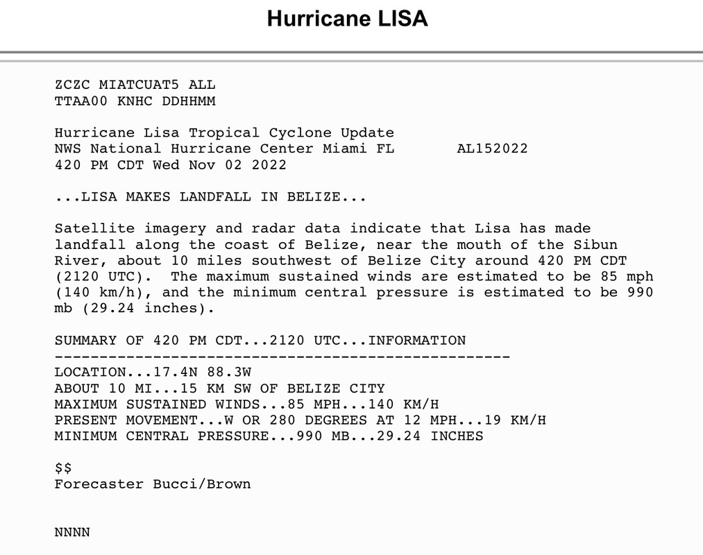
...IAN ABOUT TO MAKE LANDFALL IN SOUTHWESTERN FLORIDA...
...
SUMMARY OF 300 PM EDT...1900 UTC...INFORMATION
----------------------------------------------
LOCATION...26.6N 82.2W
ABOUT 20 MI...30 KM W OF FT MYERS FLORIDA
ABOUT 20 MI...30 KM W OF PUNTA GORDA FLORIDA
MAXIMUM SUSTAINED WINDS...155 MPH...250 KM/H
PRESENT MOVEMENT...NNE OR 15 DEGREES AT 9 MPH...15 KM/H
MINIMUM CENTRAL PRESSURE...937 MB...27.67 INCHES
EURO 24 hours out

Euro 48 hours out

No two storms are alike, but since these are fresh here's a reminder of the Euro intensity errors. This is why the HWRF always gets intensity closer than the globals, even though it's still bad.
...IAN ABOUT TO MAKE LANDFALL IN SOUTHWESTERN FLORIDA...
...
SUMMARY OF 300 PM EDT...1900 UTC...INFORMATION
----------------------------------------------
LOCATION...26.6N 82.2W
ABOUT 20 MI...30 KM W OF FT MYERS FLORIDA
ABOUT 20 MI...30 KM W OF PUNTA GORDA FLORIDA
MAXIMUM SUSTAINED WINDS...155 MPH...250 KM/H
PRESENT MOVEMENT...NNE OR 15 DEGREES AT 9 MPH...15 KM/H
MINIMUM CENTRAL PRESSURE...937 MB...27.67 INCHES
EURO 24 hours out
Euro 48 hours out
No two storms are alike, but since these are fresh here's a reminder of the Euro intensity errors. This is why the HWRF always gets intensity closer than the globals, even though it's still bad.
3 likes
M a r k
- - - - -
Join us in chat: Storm2K Chatroom Invite. Android and IOS apps also available.
The posts in this forum are NOT official forecasts and should not be used as such. Posts are NOT endorsed by any professional institution or STORM2K.org. For official information and forecasts, please refer to NHC and NWS products.
- - - - -
Join us in chat: Storm2K Chatroom Invite. Android and IOS apps also available.
The posts in this forum are NOT official forecasts and should not be used as such. Posts are NOT endorsed by any professional institution or STORM2K.org. For official information and forecasts, please refer to NHC and NWS products.
-
Blown Away

- S2K Supporter

- Posts: 10253
- Joined: Wed May 26, 2004 6:17 am
Re: ATL: NICOLE - Models
sponger wrote:Euro still weak into Northern Palm Peach.
Just an example, Lisa 85 mph, 990 mb.
Euro says Nicole 993 mb at WPB.
0 likes
Hurricane Eye Experience: David 79, Irene 99, Frances 04, Jeanne 04, Wilma 05… Hurricane Brush Experience: Andrew 92, Erin 95, Floyd 99, Matthew 16, Irma 17, Ian 22, Nicole 22…
-
tolakram
- Admin
- Posts: 20176
- Age: 62
- Joined: Sun Aug 27, 2006 8:23 pm
- Location: Florence, KY (name is Mark)
Re: ATL: NICOLE - Models

0 likes
M a r k
- - - - -
Join us in chat: Storm2K Chatroom Invite. Android and IOS apps also available.
The posts in this forum are NOT official forecasts and should not be used as such. Posts are NOT endorsed by any professional institution or STORM2K.org. For official information and forecasts, please refer to NHC and NWS products.
- - - - -
Join us in chat: Storm2K Chatroom Invite. Android and IOS apps also available.
The posts in this forum are NOT official forecasts and should not be used as such. Posts are NOT endorsed by any professional institution or STORM2K.org. For official information and forecasts, please refer to NHC and NWS products.
-
Blown Away
- S2K Supporter
- Posts: 10253
- Joined: Wed May 26, 2004 6:17 am
Re: ATL: NICOLE - Models
N2FSU wrote:0zhttps://uploads.tapatalk-cdn.com/20221108/dea8a38bf10b85d1f3a112941db7c8da.jpg
Sent from my iPhone using Tapatalk
18z GFS, EURO, and HWRF all shift S into PBC and the 00z Early TVCN shifts N to Stuart?? Maybe NHC moving GFS & Euro to the bench for Ukmet & Icon??
1 likes
Hurricane Eye Experience: David 79, Irene 99, Frances 04, Jeanne 04, Wilma 05… Hurricane Brush Experience: Andrew 92, Erin 95, Floyd 99, Matthew 16, Irma 17, Ian 22, Nicole 22…
-
gatorcane

- S2K Supporter
- Posts: 23708
- Age: 48
- Joined: Sun Mar 13, 2005 3:54 pm
- Location: Boca Raton, FL
Re: ATL: NICOLE - Models
Blown Away wrote:N2FSU wrote:0zhttps://uploads.tapatalk-cdn.com/20221108/dea8a38bf10b85d1f3a112941db7c8da.jpg
Sent from my iPhone using Tapatalk
18z GFS, EURO, and HWRF all shift S into PBC and the 00z Early TVCN shifts N to Stuart?? Maybe NHC moving GFS & Euro to the bench for Ukmet & Icon??
Doesn’t make sense. Typically a blend of the GFS and Euro is usually a good bet and they are way south of Stuart.
0 likes
-
DESTRUCTION5

- Category 5
- Posts: 4430
- Age: 44
- Joined: Wed Sep 03, 2003 11:25 am
- Location: Stuart, FL
Re: ATL: NICOLE - Models
gatorcane wrote:Blown Away wrote:N2FSU wrote:0zhttps://uploads.tapatalk-cdn.com/20221108/dea8a38bf10b85d1f3a112941db7c8da.jpg
I don't think the 18z model suite is ingested into the 00z tcvn. Think it's one run behind.
Sent from my iPhone using Tapatalk
18z GFS, EURO, and HWRF all shift S into PBC and the 00z Early TVCN shifts N to Stuart?? Maybe NHC moving GFS & Euro to the bench for Ukmet & Icon??
Doesn’t make sense. Typically a blend of the GFS and Euro is usually a good bet and they are way south of Stuart.
0 likes
GATOR NATION IS E V E R Y W H E R E !
-
AxaltaRacing24
- Category 5
- Posts: 1774
- Age: 25
- Joined: Wed Jul 27, 2016 11:14 am
- Location: Jupiter, FL
Re: ATL: NICOLE - Models
gatorcane wrote:Blown Away wrote:N2FSU wrote:0zhttps://uploads.tapatalk-cdn.com/20221108/dea8a38bf10b85d1f3a112941db7c8da.jpg
Sent from my iPhone using Tapatalk
18z GFS, EURO, and HWRF all shift S into PBC and the 00z Early TVCN shifts N to Stuart?? Maybe NHC moving GFS & Euro to the bench for Ukmet & Icon??
Doesn’t make sense. Typically a blend of the GFS and Euro is usually a good bet and they are way south of Stuart.
The TVCN is being skewed by the “weaker” models taking it more north. Not saying they’ll definitely be wrong, but that’s the current situation.
2 likes
Re: ATL: NICOLE - Models
Blown Away wrote:N2FSU wrote:0zhttps://uploads.tapatalk-cdn.com/20221108/dea8a38bf10b85d1f3a112941db7c8da.jpg
Sent from my iPhone using Tapatalk
18z GFS, EURO, and HWRF all shift S into PBC and the 00z Early TVCN shifts N to Stuart?? Maybe NHC moving GFS & Euro to the bench for Ukmet & Icon??
I’d love to see UKmet and ICON get center stage….
0 likes
Who is online
Users browsing this forum: No registered users and 15 guests