
ATL: NICOLE - Models
Moderator: S2k Moderators
-
Category5Kaiju

- Category 5

- Posts: 4326
- Joined: Thu Dec 24, 2020 12:45 pm
- Location: Seattle and Phoenix
Re: ATL: NICOLE - Models
My lord, Nicole really gets her act together near the Bahamas all into Florida.
0 likes
Unless explicitly stated, all info in my posts is based on my own opinions and observations. Tropical storms and hurricanes can be extremely dangerous. Refer to an accredited weather research agency or meteorologist if you need to make serious decisions regarding an approaching storm.
-
Spacecoast

- Category 2

- Posts: 773
- Joined: Thu Aug 31, 2017 2:03 pm
Re: ATL: NICOLE - Models
That is a major shift south from the 12z, (which was a huge NE outlier)
0 likes
-
Blown Away

- S2K Supporter

- Posts: 10253
- Joined: Wed May 26, 2004 6:17 am
Re: ATL: NICOLE - Models
cane5 wrote:Blown Away wrote:N2FSU wrote:0zhttps://uploads.tapatalk-cdn.com/20221108/dea8a38bf10b85d1f3a112941db7c8da.jpg
Sent from my iPhone using Tapatalk
18z GFS, EURO, and HWRF all shift S into PBC and the 00z Early TVCN shifts N to Stuart?? Maybe NHC moving GFS & Euro to the bench for Ukmet & Icon??
I’d love to see UKmet and ICON get center stage….
Lol, Cane5 you’ve expressed your fondness of the Icon & Ukmet and yes Icon did well with Ian. For me so many years of stubborn Icon & Ukmet tracks that ultimately cave to Euro/GFS, many many more examples than an Icon Ian victory.
0 likes
Hurricane Eye Experience: David 79, Irene 99, Frances 04, Jeanne 04, Wilma 05… Hurricane Brush Experience: Andrew 92, Erin 95, Floyd 99, Matthew 16, Irma 17, Ian 22, Nicole 22…

Re: ATL: NICOLE - Models
Blown Away wrote:cane5 wrote:Blown Away wrote:
18z GFS, EURO, and HWRF all shift S into PBC and the 00z Early TVCN shifts N to Stuart?? Maybe NHC moving GFS & Euro to the bench for Ukmet & Icon??
I’d love to see UKmet and ICON get center stage….
You got me I am really new to this as far as anything I know but the euro and the GFS. watch ICON lay an egg on this one.
1 likes
-
Coolcruiseman
- Tropical Depression

- Posts: 97
- Age: 51
- Joined: Wed Sep 21, 2022 8:10 pm
- Location: Melbourne, FL
Re: ATL: NICOLE - Models
0 likes
-
eastcoastFL

- Category 5
- Posts: 3996
- Age: 44
- Joined: Thu Apr 12, 2007 12:29 pm
- Location: Palm City, FL
Re: ATL: NICOLE - Models
Coolcruiseman wrote:00z looks to have crept a little north?
https://www.tropicaltidbits.com/stormin ... ks_00z.png
The new track just came out it’s a little north coming in around Port St. Lucie now.
1 likes
Personal Forecast Disclaimer:
The posts in this forum are NOT official forecast and should not be used as such. They are just the opinion of the poster and may or may not be backed by sound meteorological data. They are NOT endorsed by any professional institution or storm2k.org. For official information, please refer to the NHC and NWS products.
The posts in this forum are NOT official forecast and should not be used as such. They are just the opinion of the poster and may or may not be backed by sound meteorological data. They are NOT endorsed by any professional institution or storm2k.org. For official information, please refer to the NHC and NWS products.
Re: ATL: NICOLE - Models
0z icon, tad south of 18z into Vero Beach, gets back into the Gulf n of Spring hill and stays out there a bit longer than the 18z, before landfall in the Big Bend.

2 likes
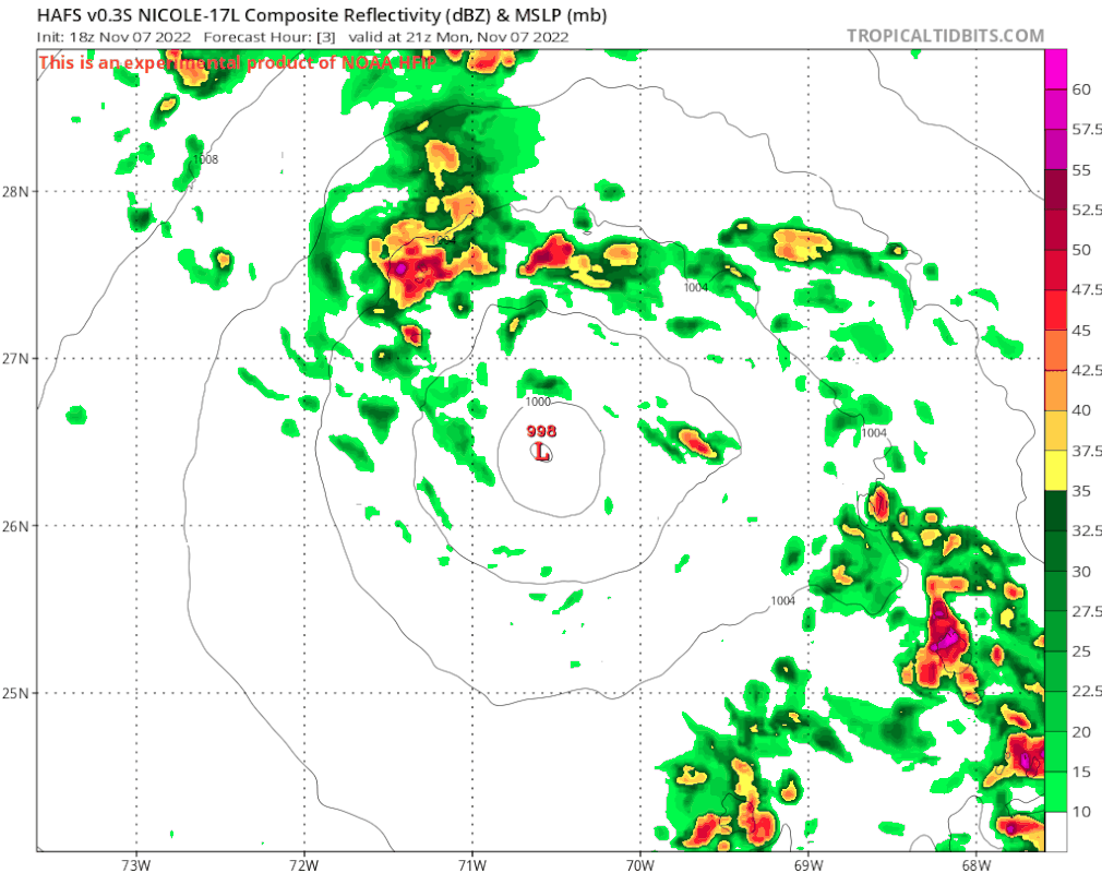
Re: ATL: NICOLE - Models
0z gfs coming in 5mb stronger than 18z as of the 27 hour mark. Init was 1000mb vs 998mb in the advisory (and whatever recon finds tonight), for what its worth.
0 likes
Re: ATL: NICOLE - Models
0z gfs stronger this time, clips in through WPB, gaining strength at landfall, (next frame after this one has 983mb inland, lake Okeechobee?) then exits into the gulf around spring hill and heads up towards St. Marks.

Last edited by BobHarlem on Mon Nov 07, 2022 10:56 pm, edited 3 times in total.
2 likes
-
Blown Away
- S2K Supporter
- Posts: 10253
- Joined: Wed May 26, 2004 6:17 am
Re: ATL: NICOLE - Models
BobHarlem wrote:0z gfs stronger this time, clips in through WPB, gaining strength at landfall.
https://i.imgur.com/sadTS42.png
1 likes
Hurricane Eye Experience: David 79, Irene 99, Frances 04, Jeanne 04, Wilma 05… Hurricane Brush Experience: Andrew 92, Erin 95, Floyd 99, Matthew 16, Irma 17, Ian 22, Nicole 22…
-
Blown Away
- S2K Supporter
- Posts: 10253
- Joined: Wed May 26, 2004 6:17 am
Re: ATL: NICOLE - Models
00z CMC… Landfall near Ft Pierce
2 likes
Hurricane Eye Experience: David 79, Irene 99, Frances 04, Jeanne 04, Wilma 05… Hurricane Brush Experience: Andrew 92, Erin 95, Floyd 99, Matthew 16, Irma 17, Ian 22, Nicole 22…
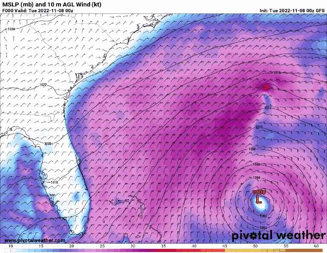
Re: ATL: NICOLE - Models
0Z UKMET: This is even more of a northern outlier with landfall Cape Canaveral vs slightly south of CC on 12Z run. 0Z is about 20 miles north of 12Z landfall and is slightly stronger. This track is 30+ miles further north than all 31 0Z GEFS members!
This initialized at 26.9N, 70.7W. The NHC actual position then was 26.7N, 70.8W. So, it initialized ~15 miles NNE of actual, which is not too far off.
TROPICAL STORM NICOLE ANALYSED POSITION : 26.9N 70.7W
ATCF IDENTIFIER : AL172022
LEAD CENTRAL MAXIMUM WIND
VERIFYING TIME TIME POSITION PRESSURE (MB) SPEED (KNOTS)
-------------- ---- -------- ------------- -------------
0000UTC 08.11.2022 0 26.9N 70.7W 1001 36
1200UTC 08.11.2022 12 27.7N 72.2W 1000 38
0000UTC 09.11.2022 24 27.0N 74.3W 998 42
1200UTC 09.11.2022 36 26.9N 76.1W 997 43
0000UTC 10.11.2022 48 27.3N 78.3W 995 47
1200UTC 10.11.2022 60 28.8N 81.3W 993 42
0000UTC 11.11.2022 72 29.9N 83.4W 995 32
1200UTC 11.11.2022 84 32.3N 83.7W 1000 29
0000UTC 12.11.2022 96 37.6N 79.7W 996 33
1200UTC 12.11.2022 108 43.8N 72.7W 984 40
0000UTC 13.11.2022 120 47.8N 61.5W 979 52
1200UTC 13.11.2022 132 CEASED TRACKING
0 likes
Personal Forecast Disclaimer:
The posts in this forum are NOT official forecasts and should not be used as such. They are just the opinion of the poster and may or may not be backed by sound meteorological data. They are NOT endorsed by any professional institution or storm2k.org. For official information, please refer to the NHC and NWS products.
The posts in this forum are NOT official forecasts and should not be used as such. They are just the opinion of the poster and may or may not be backed by sound meteorological data. They are NOT endorsed by any professional institution or storm2k.org. For official information, please refer to the NHC and NWS products.
-
AdamFirst

- S2K Supporter
- Posts: 2490
- Age: 36
- Joined: Thu Aug 14, 2008 10:54 am
- Location: Port Saint Lucie, FL
Re: ATL: NICOLE - Models
00z HWRF into Port Saint Lucie. 976mb, very ominous looking structure.
0 likes
Dolphins Marlins Canes Golden Panthers HEAT
Andrew 1992 - Irene 1999 - Frances 2004 - Jeanne 2004 - Wilma 2005 - Fay 2008 - Isaac 2012 - Matthew 2016 - Irma 2017 - Dorian 2019 - Ian 2022 - Nicole 2022 - Milton 2024
Andrew 1992 - Irene 1999 - Frances 2004 - Jeanne 2004 - Wilma 2005 - Fay 2008 - Isaac 2012 - Matthew 2016 - Irma 2017 - Dorian 2019 - Ian 2022 - Nicole 2022 - Milton 2024
Re: ATL: NICOLE - Models
Based on the 24 hour maps, my best guess is that the 0Z Euro is landfalling slightly north of the 18Z. Will see what 6 hour maps show in a bit.
Edit: Confirmed. It looks close to Ft. Pierce.
Edit: Confirmed. It looks close to Ft. Pierce.
Last edited by LarryWx on Tue Nov 08, 2022 3:30 am, edited 1 time in total.
0 likes
Personal Forecast Disclaimer:
The posts in this forum are NOT official forecasts and should not be used as such. They are just the opinion of the poster and may or may not be backed by sound meteorological data. They are NOT endorsed by any professional institution or storm2k.org. For official information, please refer to the NHC and NWS products.
The posts in this forum are NOT official forecasts and should not be used as such. They are just the opinion of the poster and may or may not be backed by sound meteorological data. They are NOT endorsed by any professional institution or storm2k.org. For official information, please refer to the NHC and NWS products.
Re: ATL: NICOLE - Models
So based on these latest runs the greater Miami area safe to say dodges a bullit again. Irma was not very impactful. Our last impactful Hurricane was Wilma and before that Andrew one of the most devastating Hurricanes in history but that was a long time ago. For anything else we had 3 Hurricanes in a row in the 60’s Donna, Cleo and Betsey. All in all in my 67 years as a native we have defied the greater odds.
0 likes
-
SouthFLTropics

- Category 5
- Posts: 4258
- Age: 50
- Joined: Thu Aug 14, 2003 8:04 am
- Location: Port St. Lucie, Florida
Re: ATL: NICOLE - Models
00z HAFS, 971mb into the Treasure Coast.
Sent from my iPhone using Tapatalk
Sent from my iPhone using Tapatalk
0 likes
Fourth Generation Florida Native
Personal Storm History: David 79, Andrew 92, Erin 95, Floyd 99, Irene 99, Frances 04, Jeanne 04, Wilma 05, Matthew 16, Irma 17, Ian 22, Nicole 22, Milton 24
Personal Storm History: David 79, Andrew 92, Erin 95, Floyd 99, Irene 99, Frances 04, Jeanne 04, Wilma 05, Matthew 16, Irma 17, Ian 22, Nicole 22, Milton 24
-
SouthFLTropics
- Category 5
- Posts: 4258
- Age: 50
- Joined: Thu Aug 14, 2003 8:04 am
- Location: Port St. Lucie, Florida
Re: ATL: NICOLE - Models
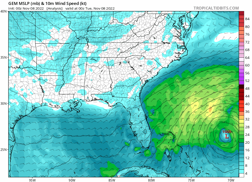
06z GFS, landfall Jupiter, 979mb… think that may be the strongest landfall from the GFS yet.
Sent from my iPhone using Tapatalk
Sent from my iPhone using Tapatalk
0 likes
Fourth Generation Florida Native
Personal Storm History: David 79, Andrew 92, Erin 95, Floyd 99, Irene 99, Frances 04, Jeanne 04, Wilma 05, Matthew 16, Irma 17, Ian 22, Nicole 22, Milton 24
Personal Storm History: David 79, Andrew 92, Erin 95, Floyd 99, Irene 99, Frances 04, Jeanne 04, Wilma 05, Matthew 16, Irma 17, Ian 22, Nicole 22, Milton 24
-
AxaltaRacing24
- Category 5
- Posts: 1774
- Age: 25
- Joined: Wed Jul 27, 2016 11:14 am
- Location: Jupiter, FL
Re: ATL: NICOLE - Models
SouthFLTropics wrote:06z GFS, landfall Jupiter, 979mb… think that may be the strongest landfall from the GFS yet.
Sent from my iPhone using Tapatalk
IDK how to feel about the GFS and Euro being this far south. Are the ICON and others onto something this time? Seems like they could be?
0 likes
Who is online
Users browsing this forum: No registered users and 15 guests