ATL: IAN - Post-Tropical - Discussion
Moderator: S2k Moderators

-
FLpanhandle91

- Category 5

- Posts: 1039
- Age: 34
- Joined: Mon Sep 13, 2010 3:50 pm
- Location: Fort Walton Beach, FL

-
ElectricStorm

- Category 5
- Posts: 5122
- Age: 24
- Joined: Tue Aug 13, 2019 11:23 pm
- Location: Skiatook, OK / Norman, OK
Re: ATL: IAN - Hurricane - Discussion
That's advisory 15A it hasn't updated yet
1 likes
B.S Meteorology, University of Oklahoma '25
Please refer to the NHC, NWS, or SPC for official information.
Please refer to the NHC, NWS, or SPC for official information.
-
eastcoastFL

- Category 5
- Posts: 3996
- Age: 44
- Joined: Thu Apr 12, 2007 12:29 pm
- Location: Palm City, FL
Re: ATL: IAN - Hurricane - Discussion
eastcoastFL wrote:Poonwalker wrote:wx98 wrote:I wouldn't put all your eggs in that particular basket just yet.
It’s not just the point but the angle as it exits and the influence of the trough at that distance created, timing included. Unless that trough is much deeper the models handled that similarly both the Euro and Gfs.
The last euro run the trough looked much deeper and it dug much further south. I don’t know if they’ll shift the track either way but i wouldn’t count on much movement west. Not a lot to support that at the moment.
East again…
Ian continues its north-northwestward trek at about 340/11 kt. The
hurricane is expected to move north-northwestward to northward
over the southeastern Gulf of Mexico during the next day or so,
along the western periphery of a subtropical ridge. After around
36 hours, the track forecast becomes more uncertain, since there is
considerable divergence of the track models in the 2-3 day
time frame. The guidance also shows considerable slowing of the
forward speed, due to a weakening of the steering currents, when
Ian approaches the west coast of Florida. This slower forward
motion is likely to prolong the storm surge, wind, and rainfall
impacts, especially along the west coast of Florida. The official
track forecast is adjusted just slightly east of the previous NHC
prediction based on the latest multi-model consensus aid, TVCN.
1 likes
Personal Forecast Disclaimer:
The posts in this forum are NOT official forecast and should not be used as such. They are just the opinion of the poster and may or may not be backed by sound meteorological data. They are NOT endorsed by any professional institution or storm2k.org. For official information, please refer to the NHC and NWS products.
The posts in this forum are NOT official forecast and should not be used as such. They are just the opinion of the poster and may or may not be backed by sound meteorological data. They are NOT endorsed by any professional institution or storm2k.org. For official information, please refer to the NHC and NWS products.
-
galaxy401

- Category 5
- Posts: 2446
- Age: 30
- Joined: Sat Aug 25, 2012 9:04 pm
- Location: Casa Grande, Arizona
Re: ATL: IAN - Hurricane - Discussion
Ian looking like a bonafide hurricane now. Here's hoping that crossing Cuba will disrupt him long enough to struggle restrengthening like Gustav did.
1 likes
Got my eyes on moving right into Hurricane Alley: Florida.
-
eastcoastFL
- Category 5
- Posts: 3996
- Age: 44
- Joined: Thu Apr 12, 2007 12:29 pm
- Location: Palm City, FL
Re: ATL: IAN - Hurricane - Discussion
ElectricStorm wrote:
That's advisory 15A it hasn't updated yet
It just updated. They shifted slightly east
1 likes
Personal Forecast Disclaimer:
The posts in this forum are NOT official forecast and should not be used as such. They are just the opinion of the poster and may or may not be backed by sound meteorological data. They are NOT endorsed by any professional institution or storm2k.org. For official information, please refer to the NHC and NWS products.
The posts in this forum are NOT official forecast and should not be used as such. They are just the opinion of the poster and may or may not be backed by sound meteorological data. They are NOT endorsed by any professional institution or storm2k.org. For official information, please refer to the NHC and NWS products.
-
eastcoastFL
- Category 5
- Posts: 3996
- Age: 44
- Joined: Thu Apr 12, 2007 12:29 pm
- Location: Palm City, FL
Re: ATL: IAN - Hurricane - Discussion
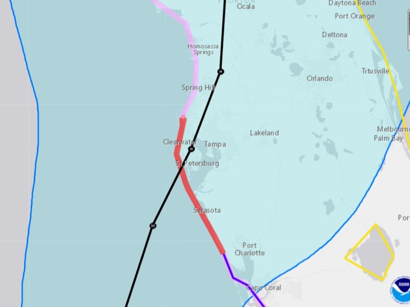
FLpanhandle91 wrote:
This is still the 8PM cone.
The graphic didn’t update but the discussion says slightly east
1 likes
Personal Forecast Disclaimer:
The posts in this forum are NOT official forecast and should not be used as such. They are just the opinion of the poster and may or may not be backed by sound meteorological data. They are NOT endorsed by any professional institution or storm2k.org. For official information, please refer to the NHC and NWS products.
The posts in this forum are NOT official forecast and should not be used as such. They are just the opinion of the poster and may or may not be backed by sound meteorological data. They are NOT endorsed by any professional institution or storm2k.org. For official information, please refer to the NHC and NWS products.
-
johngaltfla

- Category 5
- Posts: 2073
- Joined: Sun Jul 10, 2005 9:17 pm
- Location: Sarasota County, FL
- Contact:
Re: ATL: IAN - Hurricane - Discussion

Still looking bad from Sarasota through the Tampa Bay area. Surge is going to be a major problem. See y'all at 0500. Buckle up fellow Florida Man(s).
3 likes
-
ConvergenceZone
.gif)
- Category 5
- Posts: 5241
- Joined: Fri Jul 29, 2005 1:40 am
- Location: Northern California
Re: ATL: IAN - Hurricane - Discussion
Here is an in-depth question for anyone that knows the answer. So when the national hurricane center plots what path they think it will take, do the just take an average of the latest model runs? or if not, what would make them lean towards one model more than other? Just wonder what their thought process is.
1 likes

-
Coolcruiseman
- Tropical Depression

- Posts: 97
- Age: 51
- Joined: Wed Sep 21, 2022 8:10 pm
- Location: Melbourne, FL
Re: ATL: IAN - Hurricane - Discussion
Notice NHC also doesn't take it all the way to 84W, That could have potential implications for a further east track perhaps?
1 likes
-
eastcoastFL
- Category 5
- Posts: 3996
- Age: 44
- Joined: Thu Apr 12, 2007 12:29 pm
- Location: Palm City, FL
Re: ATL: IAN - Hurricane - Discussion
They’ll probably put warnings up for the center of the state in the morning if things don’t change

1 likes
Personal Forecast Disclaimer:
The posts in this forum are NOT official forecast and should not be used as such. They are just the opinion of the poster and may or may not be backed by sound meteorological data. They are NOT endorsed by any professional institution or storm2k.org. For official information, please refer to the NHC and NWS products.
The posts in this forum are NOT official forecast and should not be used as such. They are just the opinion of the poster and may or may not be backed by sound meteorological data. They are NOT endorsed by any professional institution or storm2k.org. For official information, please refer to the NHC and NWS products.
-
johngaltfla
- Category 5
- Posts: 2073
- Joined: Sun Jul 10, 2005 9:17 pm
- Location: Sarasota County, FL
- Contact:
Re: ATL: IAN - Hurricane - Discussion
NDG wrote:Forecast track right over Pinellas County now.
A nightmare for everyone from Venice north into the Bay. This could be one of the most expensive modern hurricanes ever in terms of damage considering the population density and newly built up areas it covers. Let's hope more dry air enters into the picture near the Florida coast but I'm not holding my breath.
4 likes
-
eastcoastFL
- Category 5
- Posts: 3996
- Age: 44
- Joined: Thu Apr 12, 2007 12:29 pm
- Location: Palm City, FL
Re: ATL: IAN - Hurricane - Discussion
gatorcane wrote:So a tiny shift east but not much
They didn’t fully bite on the latest euro shift. Probably want to see what the overnight models have to say and make any significant adjustments at 5am. It’s going to be a long night at the NHC dealing with this thing and making decisions on warnings. Lots of schools have been holding back on cancellations so far. Our kids school called and said school is on tomorrow but stressed that things could change quickly and we’re not expecting much impacts here.
3 likes
Personal Forecast Disclaimer:
The posts in this forum are NOT official forecast and should not be used as such. They are just the opinion of the poster and may or may not be backed by sound meteorological data. They are NOT endorsed by any professional institution or storm2k.org. For official information, please refer to the NHC and NWS products.
The posts in this forum are NOT official forecast and should not be used as such. They are just the opinion of the poster and may or may not be backed by sound meteorological data. They are NOT endorsed by any professional institution or storm2k.org. For official information, please refer to the NHC and NWS products.
-
MGC

- S2K Supporter

- Posts: 5938
- Joined: Sun Mar 23, 2003 9:05 pm
- Location: Pass Christian MS, or what is left.
Re: ATL: IAN - Hurricane - Discussion
That track forecast and slow motion will be brutal for the Tampa area.....MGC
4 likes
-
HockeyTx82
- S2K Supporter
- Posts: 2651
- Joined: Tue Oct 27, 2009 11:17 am
- Location: Ponder, TX
Re: ATL: IAN - Hurricane - Discussion
Did it shift East?
1 likes
Don't hold me accountable for anything I post on this forum. Leave the real forecasting up to the professionals.
Location: Ponder, TX (all observation posts are this location unless otherwise noted)
Location: Ponder, TX (all observation posts are this location unless otherwise noted)
Re: ATL: IAN - Hurricane - Discussion
ConvergenceZone wrote:Here is an in-depth question for anyone that knows the answer. So when the national hurricane center plots what path they think it will take, do the just take an average of the latest model runs? or if not, what would make them lean towards one model more than other? Just wonder what their thought process is.
They usually try to mirror the TVCN, which is a consensus of major model and has very good verifiability after the fact.
4 likes
-
FLpanhandle91
- Category 5
- Posts: 1039
- Age: 34
- Joined: Mon Sep 13, 2010 3:50 pm
- Location: Fort Walton Beach, FL
Who is online
Users browsing this forum: No registered users and 23 guests