
ATL: IAN - Post-Tropical - Discussion
Moderator: S2k Moderators
-
skyline385

- Category 5

- Posts: 2728
- Age: 35
- Joined: Wed Aug 26, 2020 11:15 pm
- Location: Houston TX
Re: ATL: IAN - Hurricane - Discussion
Its kinda funny that after all the flip-flopping by the models, the actual CONUS landfall will end up being very close to the first NHC cone.
16 likes

Re: ATL: IAN - Hurricane - Discussion
skyline385 wrote:Its kinda funny that after all the flip-flopping by the models, the actual CONUS landfall will end up being very close to the first NHC cone.
https://i.imgur.com/rrg6aC2.png
Remember when there was a "consensus" that it was gonna hit SE FL or panhandle?
5 likes
TC naming lists: retirements and intensity
Most aggressive Advisory #1's in North Atlantic (cr. kevin for starting the list)
Most aggressive Advisory #1's in North Atlantic (cr. kevin for starting the list)
Re: ATL: IAN - Hurricane - Discussion
Hypercane_Kyle wrote:Really looking mean tonight. CDO is a bit ragged, but that eye is definitely starting to pop.
https://i.imgur.com/3C20byl.jpg
Land interaction and friction I would assume.
1 likes
Re: ATL: IAN - Hurricane - Discussion
Hypercane_Kyle wrote:Really looking mean tonight. CDO is a bit ragged, but that eye is definitely starting to pop.
https://i.imgur.com/3C20byl.jpg
Land interaction and friction I would assume.
1 likes
-
AJC3

- Admin

- Posts: 4152
- Age: 62
- Joined: Tue Aug 31, 2004 7:04 pm
- Location: Ballston Spa, New York
- Contact:
Re: ATL: IAN - Hurricane - Discussion
GeneratorPower wrote:cheezyWXguy wrote:Should note the eye we’re seeing on IR is only the eastern half. The western half is still underneath convection, so that probably accounts for the discrepancy we’re seeing between IR and radar
Just use Key West radar. It’s in range.
Even better is La Bajada, Cuba...
https://bmcnoldy.rsmas.miami.edu/tropic ... 22_lbj.gif
3 likes
Re: ATL: IAN - Hurricane - Discussion
pcolaman wrote:
Land interaction and friction I would assume.
Trochoidal deformity from RI...
5 likes

Re: ATL: IAN - Hurricane - Discussion
Looking at the satellite over the past couple of hours, it seems evident that there is some drier layer of air beginning to encroach Ian's west quad. I think there's a chance that we see some dry air entrained while the storm is over W. Cuba. Two things that I can see as a result. One, that Ian will look particularly disheveled following it's Cuban foray. Two, I can see this causing a temporary relocation causing the COC to scoot a tad east of north within the deepest convection.
3 likes
Andy D
(For official information, please refer to the NHC and NWS products.)
(For official information, please refer to the NHC and NWS products.)
-
Craters
- Category 1

- Posts: 428
- Joined: Sat Aug 24, 2013 2:34 pm
- Location: Alvin, TX (south of Houston)
Re: ATL: IAN - Hurricane - Discussion
In the event that folks might be looking for free radar sites right about now, here are a few:
NOAA Aviation Radar https://aviationweather.gov/radar
National Center for Atmospheric Research (NCAR) https://weather.ral.ucar.edu/radar/
National Weather Service (NWS) https://radar.weather.gov/
Live Weather Radar https://www.livewxradar.com/
RainViewer https://www.rainviewer.com/weather-radar-map-live.html
There are certainly others, but one of these might work for you. They're all different in one way or another, but the one thing they have in common is their freeness.
8 likes
Nothing that I post here should ever be treated as a forecast or anything resembling one. Please check with your local NWS office or the NHC for forecasts, watches, and warnings.
-
skyline385
- Category 5
- Posts: 2728
- Age: 35
- Joined: Wed Aug 26, 2020 11:15 pm
- Location: Houston TX
Re: ATL: IAN - Hurricane - Discussion
chaser1 wrote:Looking at the satellite over the past couple of hours, it seems evident that there is some drier layer of air beginning to encroach Ian's west quad. I think there's a chance that we see some dry air entrained while the storm is over W. Cuba. Two things that I can see as a result. One, that Ian will look particularly disheveled following it's Cuban foray. Two, I can see this causing a temporary relocation causing the COC to scoot a tad east of north within the deepest convection.
Yea its kinda hard to see but there is a pretty decent sized pocket to the west.

1 likes
-
Hurricane Mike
- Category 2

- Posts: 675
- Joined: Tue Apr 10, 2018 7:44 am
Re: ATL: IAN - Hurricane - Discussion
Same thing happened with Charley in 2004. The early tracks from the NHC ended up being dead-on.
1 likes
-
CrazyC83
- Professional-Met

- Posts: 34308
- Joined: Tue Mar 07, 2006 11:57 pm
- Location: Deep South, for the first time!
Re: ATL: IAN - Hurricane - Discussion
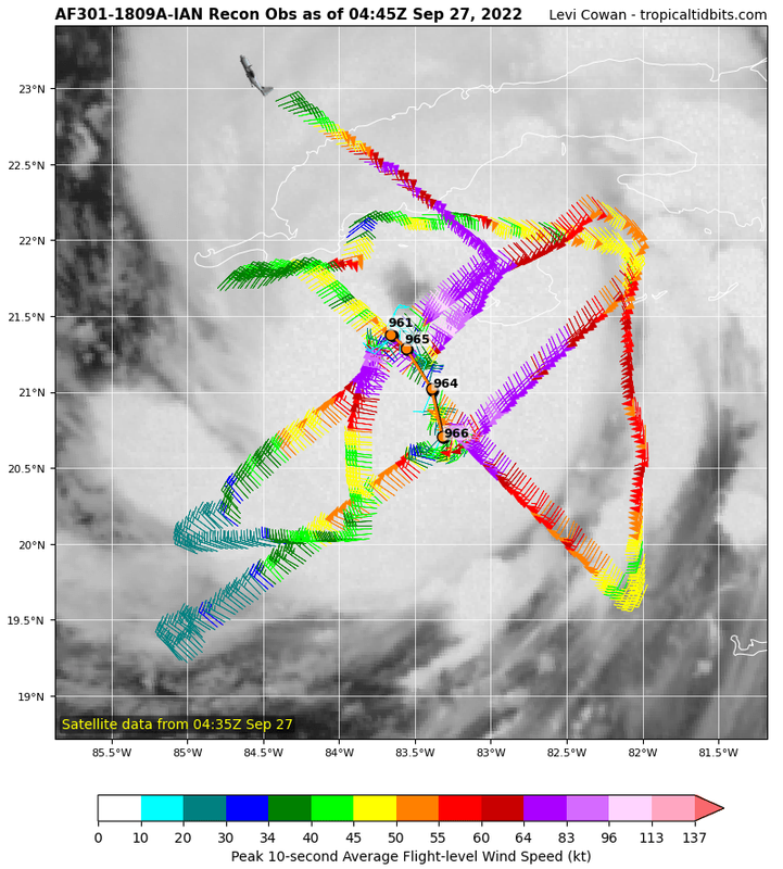
I believe the next Recon flight is from Kermit and leaves around 4 am. That will likely be right around when it is over Cuba, so it would only sample the peripheral winds.
1 likes
-
Meteorcane

- Category 2
- Posts: 559
- Joined: Thu Jul 21, 2011 6:49 am
- Location: North Platte Nebraska
Re: ATL: IAN - Hurricane - Discussion
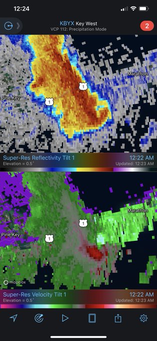
Gradually seeing Ian's wind fields spreading over the Florida keys and enhancing low-level shear. An obvious waterspout and potential tornado near marathon a few minutes ago. This threat is going to spread northward as Ian moves northward, and will definitely bear watching for SFL.
Last edited by Meteorcane on Mon Sep 26, 2022 11:53 pm, edited 2 times in total.
2 likes
-
AdamFirst

- S2K Supporter

- Posts: 2490
- Age: 36
- Joined: Thu Aug 14, 2008 10:54 am
- Location: Port Saint Lucie, FL
Re: ATL: IAN - Hurricane - Discussion
Tornado warning for a hook passing over the Seven Mile Bridge in the middle Keys.
There's going to be a substantial tornado threat in this hurricane that will spread north as Tuesday goes on.
https://twitter.com/NWSKeyWest/status/1574616878542073857
There's going to be a substantial tornado threat in this hurricane that will spread north as Tuesday goes on.
https://twitter.com/NWSKeyWest/status/1574616878542073857
2 likes
Dolphins Marlins Canes Golden Panthers HEAT
Andrew 1992 - Irene 1999 - Frances 2004 - Jeanne 2004 - Wilma 2005 - Fay 2008 - Isaac 2012 - Matthew 2016 - Irma 2017 - Dorian 2019 - Ian 2022 - Nicole 2022 - Milton 2024
Andrew 1992 - Irene 1999 - Frances 2004 - Jeanne 2004 - Wilma 2005 - Fay 2008 - Isaac 2012 - Matthew 2016 - Irma 2017 - Dorian 2019 - Ian 2022 - Nicole 2022 - Milton 2024
Re: ATL: IAN - Hurricane - Discussion
I would not be surprised if there are additional eastward shifts in the track. My gut says this storm goes in south of tampa bay. But i'm no pro and can't decipher how much of that is wishful thinking.
1 likes
-
Poonwalker
- Category 1
- Posts: 270
- Joined: Tue Sep 20, 2022 11:12 am
Re: ATL: IAN - Hurricane - Discussion
Teban54 wrote:skyline385 wrote:Its kinda funny that after all the flip-flopping by the models, the actual CONUS landfall will end up being very close to the first NHC cone.
https://i.imgur.com/rrg6aC2.png
Remember when there was a "consensus" that it was gonna hit SE FL or panhandle?
What about Mr Scrambled Eggs. Lol.
1 likes
-
galaxy401

- Category 5
- Posts: 2446
- Age: 30
- Joined: Sat Aug 25, 2012 9:04 pm
- Location: Casa Grande, Arizona
Re: ATL: IAN - Hurricane - Discussion
Since there's going to be no more recon passes until its landfall on Cuba, had to think the NHC will probably upgrade Ian to a Category 3 by then. That last recon pass and continued organization.
2 likes
Got my eyes on moving right into Hurricane Alley: Florida.
-
Hypercane_Kyle

- Category 5
- Posts: 3465
- Joined: Sat Mar 07, 2015 7:58 pm
- Location: Cape Canaveral, FL
Re: ATL: IAN - Hurricane - Discussion
galaxy401 wrote:Since there's going to be no more recon passes until its landfall on Cuba, had to think the NHC will probably upgrade Ian to a Category 3 by then. That last recon pass and continued organization.
My guess is, if the IR presentation continues to improve, you're going to be exactly right.
2 likes
My posts are my own personal opinion, defer to the National Hurricane Center (NHC) and other NOAA products for decision making during hurricane season.

-
Meteorcane
- Category 2
- Posts: 559
- Joined: Thu Jul 21, 2011 6:49 am
- Location: North Platte Nebraska
Re: ATL: IAN - Hurricane - Discussion
Best satellite presentation of its lifetime right now... AdjT up to 5.7... wouldn't be surprised if they nudge it to major at 2am.

1 likes
Re: ATL: IAN - Hurricane - Discussion
Eye getting rounder every frame, cloud tops cooling to the north, and hot towers in the SW quad remains persistent. Looking the healthiest it has ever been.

1 likes
TC naming lists: retirements and intensity
Most aggressive Advisory #1's in North Atlantic (cr. kevin for starting the list)
Most aggressive Advisory #1's in North Atlantic (cr. kevin for starting the list)
Who is online
Users browsing this forum: No registered users and 15 guests