ATL: IAN - Post-Tropical - Discussion

Moderator: S2k Moderators

Message
Author
Patrick99
Category 5
Category 5
Posts: 1772
Joined: Mon May 24, 2004 3:43 pm
Location: SW Broward, FL

Re: ATL: IAN - Hurricane - Discussion

#3141 Postby Patrick99 » Tue Sep 27, 2022 9:33 am

SFLcane wrote:
eastcoastFL wrote:


Looks like it’s NNE a little in that frame but funny movements do happen over land. Hopefully it doesn’t continue this motion over water.


Oh i think its surely got some eastward component right now.


I think so, I think the biggest question now other than intensity is just "how much" eastern component for how long
2 likes   

User avatar
Kazmit
Category 5
Category 5
Posts: 2125
Age: 22
Joined: Mon Jul 25, 2016 8:49 am
Location: Williamsburg, VA / Bermuda

Re: ATL: IAN - Hurricane - Discussion

#3142 Postby Kazmit » Tue Sep 27, 2022 9:33 am

Is recon not reporting pressure or is the instrument not working?
1 likes   
Igor 2010, Sandy 2012, Fay 2014, Gonzalo 2014, Joaquin 2015, Nicole 2016, Humberto 2019

I am only a tropical weather enthusiast. My predictions are not official and may or may not be backed by sound meteorological data. For official information, please refer to the NHC and NWS products.

TheHurricaneGod
Tropical Storm
Tropical Storm
Posts: 151
Age: 22
Joined: Thu Apr 16, 2020 6:19 pm
Location: Fort Lauderdale

Re: ATL: IAN - Hurricane - Discussion

#3143 Postby TheHurricaneGod » Tue Sep 27, 2022 9:34 am

MIGHT be seeing a more ENE/NE component now. At least temporarily. I am looking at the mesoscale 1-minute floater. Last 30 minutes seem to be more ENE.
5 likes   

User avatar
skyline385
Category 5
Category 5
Posts: 2728
Age: 35
Joined: Wed Aug 26, 2020 11:15 pm
Location: Houston TX

Re: ATL: IAN - Hurricane - Discussion

#3144 Postby skyline385 » Tue Sep 27, 2022 9:34 am

Looks like we have lighting in the eyewall

Image


Sent from my iPhone using Tapatalk
2 likes   

User avatar
Iceresistance
Category 5
Category 5
Posts: 9290
Age: 21
Joined: Sat Oct 10, 2020 9:45 am
Location: Tecumseh, OK/Norman, OK

Re: ATL: IAN - Hurricane - Discussion

#3145 Postby Iceresistance » Tue Sep 27, 2022 9:34 am

Kazmit wrote:Is recon not reporting pressure or is the instrument not working?

Not reporting pressure at all, it did have an unflagged 98 knots SMFR from the first attempted pass.
1 likes   
Bill 2015 & Beta 2020

Winter 2020-2021 :cold:

All observations are in Tecumseh, OK unless otherwise noted.

Winter posts are focused mainly for Oklahoma & Texas.

Take any of my forecasts with a grain of salt, refer to the NWS, SPC, and NHC for official information

Never say Never with weather! Because ANYTHING is possible!

User avatar
SFLcane
S2K Supporter
S2K Supporter
Posts: 10163
Age: 47
Joined: Sat Jun 05, 2010 1:44 pm
Location: Lake Worth Florida

Re: ATL: IAN - Hurricane - Discussion

#3146 Postby SFLcane » Tue Sep 27, 2022 9:35 am

Trof certainly digging you can see it on WV Ian will not be able to go much further north soon without being kicked out.

Image
5 likes   

User avatar
Blown Away
S2K Supporter
S2K Supporter
Posts: 10157
Joined: Wed May 26, 2004 6:17 am

Re: ATL: IAN - Hurricane - Discussion

#3147 Postby Blown Away » Tue Sep 27, 2022 9:37 am

Image
4 likes   
Hurricane Eye Experience: David 79, Irene 99, Frances 04, Jeanne 04, Wilma 05… Hurricane Brush Experience: Andrew 92, Erin 95, Floyd 99, Matthew 16, Irma 17, Ian 22, Nicole 22…

User avatar
cycloneye
Admin
Admin
Posts: 145735
Age: 68
Joined: Thu Oct 10, 2002 10:54 am
Location: San Juan, Puerto Rico

Re: ATL: IAN - Hurricane - Discussion

#3148 Postby cycloneye » Tue Sep 27, 2022 9:37 am

Kazmit wrote:Is recon not reporting pressure or is the instrument not working?


Not working for now. Let's see if they release a VDM.
2 likes   
Visit the Caribbean-Central America Weather Thread where you can find at first post web cams,radars
and observations from Caribbean basin members Click Here

Patrick99
Category 5
Category 5
Posts: 1772
Joined: Mon May 24, 2004 3:43 pm
Location: SW Broward, FL

Re: ATL: IAN - Hurricane - Discussion

#3149 Postby Patrick99 » Tue Sep 27, 2022 9:37 am

Weatherboy1 wrote:
Sanibel wrote:This is Charley after coming back from the Pet Cemetery IMO...


You can see the trough on Water Vapor Imagery...


The posts in this forum are NOT official forecasts and should not be used as such. They are just the opinion of the poster and may or may not be backed by sound meteorological data. They are NOT endorsed by any professional institution or STORM2K. For official information, please refer to products from the National Hurricane Center and National Weather Service.


Yes, that is my concern/worry as well. Also memories of Irene in 1999, which was supposed to hit the SW FL coast and ride straight up the spine of the state. Instead, she moved NNE and NE and exited the state right over my home in Jupiter.


Yeah, I'm not saying it will happen, but I too am traumatized by Irene. We didn't even get a day off from work for that because it "wasn't supposed to hit." Had to drive home from work that afternoon in some of the worst driving conditions I've ever seen.
6 likes   

User avatar
skyline385
Category 5
Category 5
Posts: 2728
Age: 35
Joined: Wed Aug 26, 2020 11:15 pm
Location: Houston TX

Re: ATL: IAN - Hurricane - Discussion

#3150 Postby skyline385 » Tue Sep 27, 2022 9:37 am

Image


Sent from my iPhone using Tapatalk
2 likes   

Michele B
S2K Supporter
S2K Supporter
Posts: 1114
Joined: Thu Aug 25, 2016 8:08 am
Location: SWFL

Re: ATL: IAN - Hurricane - Discussion

#3151 Postby Michele B » Tue Sep 27, 2022 9:39 am

Iceresistance wrote:
underthwx wrote:
Iceresistance wrote:
This unfortunately does not appear to be the case because the wind shear appears to be favorable directionally.


Unless I'm mistaken, Wxman57 discussed the shear that will affect Ian, and weaken it somewhat upon its approach to land...this is an excerpt from the 5am NHC discussion..."By 24
to 36 hours, increasing southwesterly vertical wind shear and drier
mid-level air are likely to result in some gradual weakening." By favorable wind shear, do you mean favorable because it will weaken Ian somewhat?....Just to be clear Ice, thanks!


The direction of the wind shear is currently favorable for more intensification because the storm is moving in the same direction as the shear, but the direction will eventually change in the next 48-72 hours to unfavorable direction combined with dry air behind this cold front.


I've been wondering about this too.

I know the placement of the front and its steering currents were major considerations when we were trying to figure all this out. Now, we've not heard anymore about where the front is, where it's going to be, and how much it will continue to "steer" the storm.
2 likes   
Cleo - 1964, Betsy - 1965, David - 1979, Andrew - 1992, Charlie (Francis, Ivan, Jeanne) - 2004, Irma - 2017, Ian - 2022

wx98
Category 5
Category 5
Posts: 1383
Joined: Sat Aug 25, 2018 9:24 pm

Re: ATL: IAN - Hurricane - Discussion

#3152 Postby wx98 » Tue Sep 27, 2022 9:40 am

With the way this is trying to turn NNE, I think we need to be thinking about and anticipating landfall as far south as Naples/Cape Coral.
4 likes   

User avatar
aspen
Category 5
Category 5
Posts: 8820
Joined: Sat Oct 12, 2019 7:10 pm
Location: Connecticut, USA

Re: ATL: IAN - Hurricane - Discussion

#3153 Postby aspen » Tue Sep 27, 2022 9:41 am

skyline385 wrote:Looks like we have lighting in the eyewall

https://uploads.tapatalk-cdn.com/20220927/97555c24577da0b7f91861bc03bb2d7d.gif


Sent from my iPhone using Tapatalk

Recon reported a spike in hurricane-force FL winds in those NE bands, but I don’t think it can counted as a true double wind maxima because they don’t wrap around the core. It could be difficult for a secondary eyewall to form because of proximity to Cuba and the flow from the SW.
2 likes   
Irene '11 Sandy '12 Hermine '16 5/15/2018 Derecho Fay '20 Isaias '20 Elsa '21 Henri '21 Ida '21

I am only a meteorology enthusiast who knows a decent amount about tropical cyclones. Look to the professional mets, the NHC, or your local weather office for the best information.

dpep4
Tropical Storm
Tropical Storm
Posts: 198
Joined: Sat Sep 09, 2017 9:04 pm

Re: ATL: IAN - Hurricane - Discussion

#3154 Postby dpep4 » Tue Sep 27, 2022 9:42 am

eastcoastFL wrote:
underthwx wrote:
tolakram wrote:
I believe all of you that heard it. Do you believe that's the information the NHC wanted out there? The same organization that is emphatic about not following the line? Knowing the past NHC accuracy is that the correct message to spread and if not, why spread it?


Seems to happen with most storms, I've heard some erroneous and alarming soundbytes on the tube before, that just ain't so...I find it disturbing to be honest, sends the wrong message...like you say Tolakram, stick with direct info from the NHC, and of course, 2K....


I missed it. What did the governor say?


He and his emergency mgmt director said what the NHC told them:

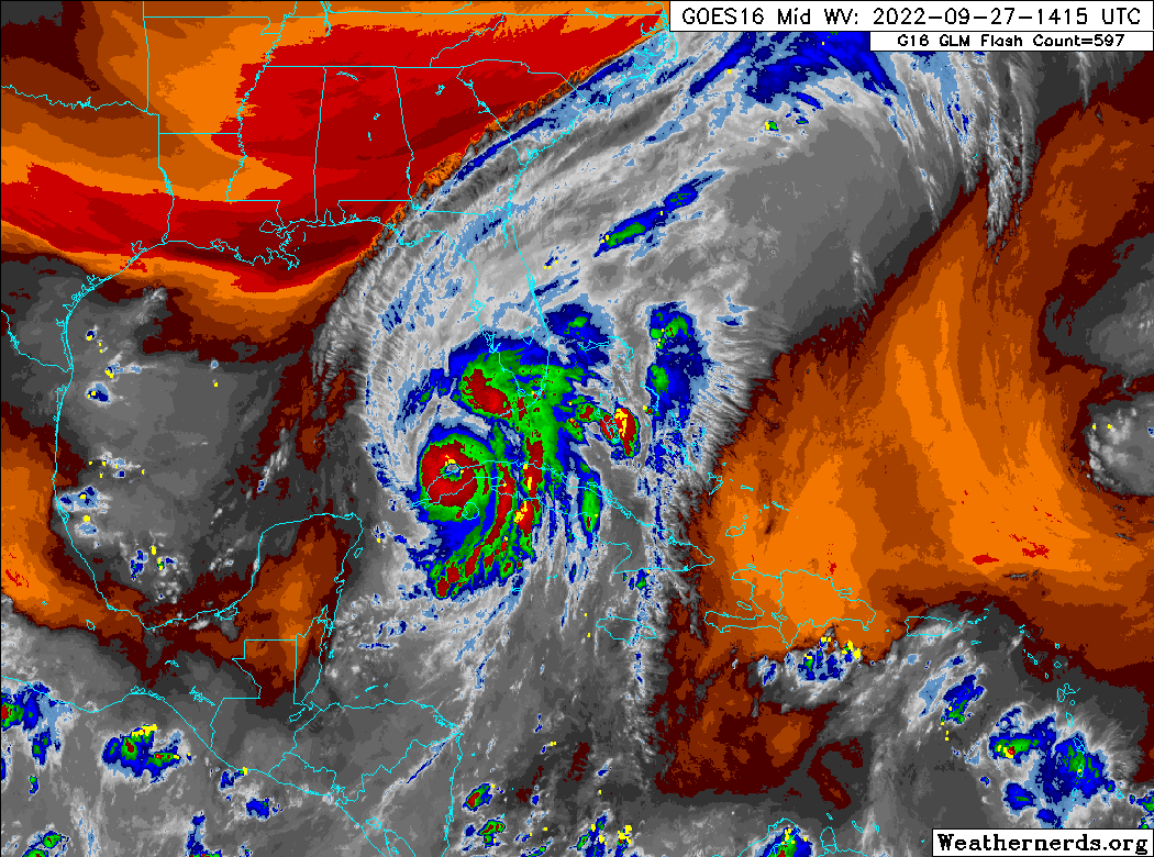
https://www.cbsnews.com/live-updates/hurricane-ian-tracker-florida-forecast-path-cuba-2022-09-27/

"The National Hurricane Center is now predicting that landfall will be Venice in 35 hours, at 125 mph ... making it a major, Category 3, landfalling hurricane," Kevin Guthrie, director for the Florida Division of Emergency Management, said at a press conference Tuesday morning.

"It's important to say that Tampa Bay region, you are not out of the woods yet. There is still going to be a storm surge event in the Tampa Bay region," Guthrie said. "You need to continue to heed the warnings that are in place for Pinellas, Tampa, Manatee, Hillsborough. Do not return yet if you have evacuated."

Edit: Here's the video of the press conference:

[Youtube]https://www.youtube.com/watch?v=GAKcbwYur3g[/Youtube]

https://www.youtube.com/watch?v=GAKcbwYur3g
Last edited by dpep4 on Tue Sep 27, 2022 9:55 am, edited 3 times in total.
2 likes   

User avatar
Iceresistance
Category 5
Category 5
Posts: 9290
Age: 21
Joined: Sat Oct 10, 2020 9:45 am
Location: Tecumseh, OK/Norman, OK

Re: ATL: IAN - Hurricane - Discussion

#3155 Postby Iceresistance » Tue Sep 27, 2022 9:43 am

Michele B wrote:
Iceresistance wrote:
underthwx wrote:
Unless I'm mistaken, Wxman57 discussed the shear that will affect Ian, and weaken it somewhat upon its approach to land...this is an excerpt from the 5am NHC discussion..."By 24
to 36 hours, increasing southwesterly vertical wind shear and drier
mid-level air are likely to result in some gradual weakening." By favorable wind shear, do you mean favorable because it will weaken Ian somewhat?....Just to be clear Ice, thanks!


The direction of the wind shear is currently favorable for more intensification because the storm is moving in the same direction as the shear, but the direction will eventually change in the next 48-72 hours to unfavorable direction combined with dry air behind this cold front.


I've been wondering about this too.

I know the placement of the front and its steering currents were major considerations when we were trying to figure all this out. Now, we've not heard anymore about where the front is, where it's going to be, and how much it will continue to "steer" the storm.


Per WPC, the cold front from near Jacksonville to north and east of Gainesville.
3 likes   
Bill 2015 & Beta 2020

Winter 2020-2021 :cold:

All observations are in Tecumseh, OK unless otherwise noted.

Winter posts are focused mainly for Oklahoma & Texas.

Take any of my forecasts with a grain of salt, refer to the NWS, SPC, and NHC for official information

Never say Never with weather! Because ANYTHING is possible!

Javlin
Category 5
Category 5
Posts: 1621
Age: 64
Joined: Fri Jul 09, 2004 7:58 pm
Location: ms gulf coast

Re: ATL: IAN - Hurricane - Discussion

#3156 Postby Javlin » Tue Sep 27, 2022 9:44 am

The cloud structure along with the movement seems to indicate the NE movement starts earlier than later.
1 likes   

User avatar
Iceresistance
Category 5
Category 5
Posts: 9290
Age: 21
Joined: Sat Oct 10, 2020 9:45 am
Location: Tecumseh, OK/Norman, OK

Re: ATL: IAN - Hurricane - Discussion

#3157 Postby Iceresistance » Tue Sep 27, 2022 9:45 am

Recon has confirmed that the Center of Ian is now in the GoM

Image
https://s4.gifyu.com/images/recon_AF302-2109A-IAN_zoom.png
5 likes   
Bill 2015 & Beta 2020

Winter 2020-2021 :cold:

All observations are in Tecumseh, OK unless otherwise noted.

Winter posts are focused mainly for Oklahoma & Texas.

Take any of my forecasts with a grain of salt, refer to the NWS, SPC, and NHC for official information

Never say Never with weather! Because ANYTHING is possible!

underthwx
Category 5
Category 5
Posts: 2363
Joined: Sat Jul 30, 2011 2:14 pm
Location: Brazoria County Texas

Re: ATL: IAN - Hurricane - Discussion

#3158 Postby underthwx » Tue Sep 27, 2022 9:46 am

Michele B wrote:
Iceresistance wrote:
underthwx wrote:
Unless I'm mistaken, Wxman57 discussed the shear that will affect Ian, and weaken it somewhat upon its approach to land...this is an excerpt from the 5am NHC discussion..."By 24
to 36 hours, increasing southwesterly vertical wind shear and drier
mid-level air are likely to result in some gradual weakening." By favorable wind shear, do you mean favorable because it will weaken Ian somewhat?....Just to be clear Ice, thanks!


The direction of the wind shear is currently favorable for more intensification because the storm is moving in the same direction as the shear, but the direction will eventually change in the next 48-72 hours to unfavorable direction combined with dry air behind this cold front.


I've been wondering about this too.

I know the placement of the front and its steering currents were major considerations when we were trying to figure all this out. Now, we've not heard anymore about where the front is, where it's going to be, and how much it will continue to "steer" the storm.


I understand there are multiple factors regarding the steering mechanisms with Ian, from reading NHC discussions, and all the great info right here on 2K...to me, this is a complex setup with Ian, and I too am anxious to learn more about the front, and it's significance in the steering of Ian...
1 likes   

wx98
Category 5
Category 5
Posts: 1383
Joined: Sat Aug 25, 2018 9:24 pm

Re: ATL: IAN - Hurricane - Discussion

#3159 Postby wx98 » Tue Sep 27, 2022 9:46 am

Per recon this is likely down to a Cat 1 or low end Cat 2. I don’t expect NHC to drop it near that low in operational advisories. Now we have to see if it truly reintensifies or if it gets stuck in the loop of dropping pressure and expanding wind field.
0 likes   

User avatar
Blown Away
S2K Supporter
S2K Supporter
Posts: 10157
Joined: Wed May 26, 2004 6:17 am

Re: ATL: IAN - Hurricane - Discussion

#3160 Postby Blown Away » Tue Sep 27, 2022 9:48 am

I'm guessing the upcoming 11sm Disco will reveal this potential E shift...
1 likes   
Hurricane Eye Experience: David 79, Irene 99, Frances 04, Jeanne 04, Wilma 05… Hurricane Brush Experience: Andrew 92, Erin 95, Floyd 99, Matthew 16, Irma 17, Ian 22, Nicole 22…


Return to “2022”

Who is online

Users browsing this forum: No registered users and 6 guests