ATL: IAN - Post-Tropical - Discussion
Moderator: S2k Moderators
-
Hurricaneman

- Category 5

- Posts: 7404
- Age: 45
- Joined: Tue Aug 31, 2004 3:24 pm
- Location: central florida
Re: ATL: IAN - Hurricane - Discussion
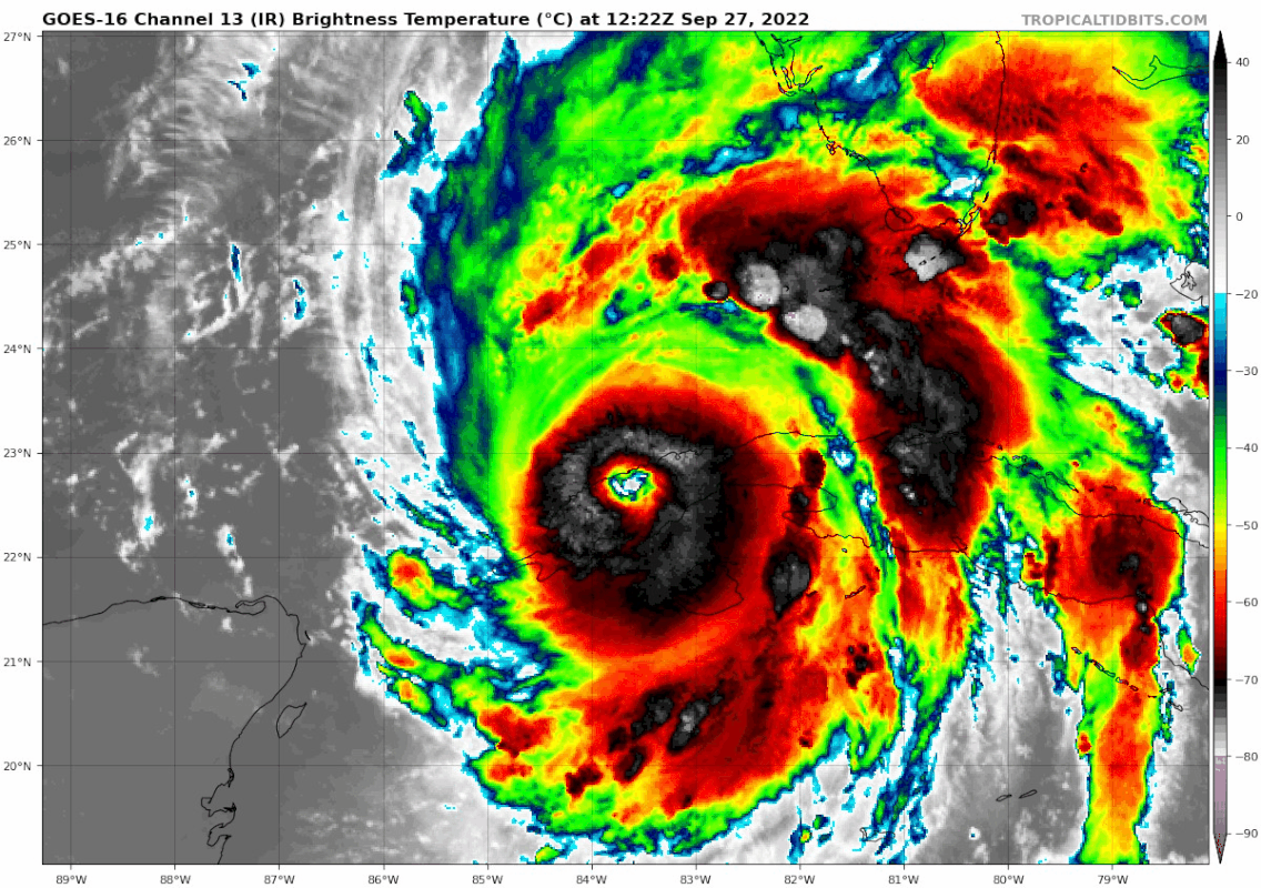
It’s definitely moving NNE but not as northeast as some are saying, some of the more perceived NE movement is the clearing of the eye
3 likes

Re: ATL: IAN - Hurricane - Discussion
wx98 wrote:Per recon this is likely down to a Cat 1 or low end Cat 2. I don’t expect NHC to drop it near that low in operational advisories. Now we have to see if it truly reintensifies or if it gets stuck in the loop of dropping pressure and expanding wind field.
No cat 1 has that satellite appearance. The mountains are likely preventing the winds that would occur over water.
12 likes
Igor 2010, Sandy 2012, Fay 2014, Gonzalo 2014, Joaquin 2015, Nicole 2016, Humberto 2019, Imelda 2025
I am only a tropical weather enthusiast. My predictions are not official and may or may not be backed by sound meteorological data. For official information, please refer to the NHC and NWS products.
I am only a tropical weather enthusiast. My predictions are not official and may or may not be backed by sound meteorological data. For official information, please refer to the NHC and NWS products.
-
ElectricStorm

- Category 5
- Posts: 5124
- Age: 24
- Joined: Tue Aug 13, 2019 11:23 pm
- Location: Norman, OK
Re: ATL: IAN - Hurricane - Discussion
Looks like the interaction with Cuba managed to knock down the winds some, but that structure still looks fantastic and this will probably bomb to a Cat 4 later today or overnight unfortunately
1 likes
B.S Meteorology, University of Oklahoma '25
Please refer to the NHC, NWS, or SPC for official information.
Please refer to the NHC, NWS, or SPC for official information.

Re: ATL: IAN - Hurricane - Discussion
Credit to Jonah Heinl on another board posting this. I don't know if this is accurate.
Last edited by blp on Tue Sep 27, 2022 9:51 am, edited 2 times in total.
5 likes
The following post is NOT an official forecast and should not be used as such. It is just the opinion of the poster and may or may not be backed by sound meteorological data. It is NOT endorsed by any professional institution including storm2k.org For Official Information please refer to the NHC and NWS products.
-
Jelmergraaff
- Tropical Storm

- Posts: 138
- Age: 23
- Joined: Fri Aug 27, 2021 1:00 pm
- Location: The Netherlands
Re: ATL: IAN - Hurricane - Discussion
wx98 wrote:Per recon this is likely down to a Cat 1 or low end Cat 2. I don’t expect NHC to drop it near that low in operational advisories. Now we have to see if it truly reintensifies or if it gets stuck in the loop of dropping pressure and expanding wind field.
Wouldn't personally put this at a Cat 1. There was a SFMR of 95kt, which is borderline Cat 2/Cat 3. Dropsonde in NE eyewall showed 86kt at the surface with 103kt at some 200m height. My best estimate right now would be around 95kt/100kt.
8 likes
21-year old meteorologist and student MSc Climate Studies from The Netherlands. Interested in all fields of meteorology and climatology, including tropical systems like hurricanes.
-
Blown Away

- S2K Supporter

- Posts: 10253
- Joined: Wed May 26, 2004 6:17 am
Re: ATL: IAN - Hurricane - Discussion

Amazing this NE movement, little burst of acceleration in last few frames.
7 likes
Hurricane Eye Experience: David 79, Irene 99, Frances 04, Jeanne 04, Wilma 05… Hurricane Brush Experience: Andrew 92, Erin 95, Floyd 99, Matthew 16, Irma 17, Ian 22, Nicole 22…
-
Kingarabian

- S2K Supporter
- Posts: 16338
- Joined: Sat Aug 08, 2009 3:06 am
- Location: Honolulu, Hawaii
Re: ATL: IAN - Hurricane - Discussion
Second example this year that Dvorak can be misleading. Still a formidable system with a lot of warm water ahead of it.
2 likes
RIP Kobe Bryant
-
SFLcane

- S2K Supporter
- Posts: 10281
- Age: 48
- Joined: Sat Jun 05, 2010 1:44 pm
- Location: Lake Worth Florida
Re: ATL: IAN - Hurricane - Discussion
Blown Away wrote:https://i.imgur.com/Mcooqnp.gif
Amazing this NE movement, little burst of acceleration in last few frames.
Yea we will have to see if its a wobble but there is certainly some eastern component right now.
2 likes

Re: ATL: IAN - Hurricane - Discussion
Clearing out the eye as soon as it could.
4 likes
TC naming lists: retirements and intensity
Most aggressive Advisory #1's in North Atlantic (cr. kevin for starting the list)
Most aggressive Advisory #1's in North Atlantic (cr. kevin for starting the list)
-
Iceresistance

- Category 5
- Posts: 9564
- Age: 22
- Joined: Sat Oct 10, 2020 9:45 am
- Location: Tecumseh, OK/Norman, OK
Re: ATL: IAN - Hurricane - Discussion
ADT is at 6.3
It's too high, but the structure of this system is impressive.
UW - CIMSS
ADVANCED DVORAK TECHNIQUE
ADT-Version 9.0
Tropical Cyclone Intensity Algorithm
----- Current Analysis -----
Date : 27 SEP 2022 Time : 142020 UTC
Lat : 23:01:12 N Lon : 83:27:35 W
CI# /Pressure/ Vmax
6.3 / 937mb / 122kts
Final T# Adj T# Raw T#
6.3 6.3 6.3
Estimated radius of max. wind based on IR : 20 km
Center Temp : +11.6C Cloud Region Temp : -67.5C
Scene Type : EYE
Subtropical Adjustment : OFF
Extratropical Adjustment : OFF
It's too high, but the structure of this system is impressive.
1 likes
Bill 2015 & Beta 2020
Winter 2020-2021
All observations are in Tecumseh, OK unless otherwise noted.
Winter posts are focused mainly for Oklahoma & Texas.
Take any of my forecasts with a grain of salt, refer to the NWS, SPC, and NHC for official information
Never say Never with weather! Because ANYTHING is possible!
Winter 2020-2021
All observations are in Tecumseh, OK unless otherwise noted.
Winter posts are focused mainly for Oklahoma & Texas.
Take any of my forecasts with a grain of salt, refer to the NWS, SPC, and NHC for official information
Never say Never with weather! Because ANYTHING is possible!
-
skyline385

- Category 5
- Posts: 2728
- Age: 35
- Joined: Wed Aug 26, 2020 11:15 pm
- Location: Houston TX
Re: ATL: IAN - Hurricane - Discussion
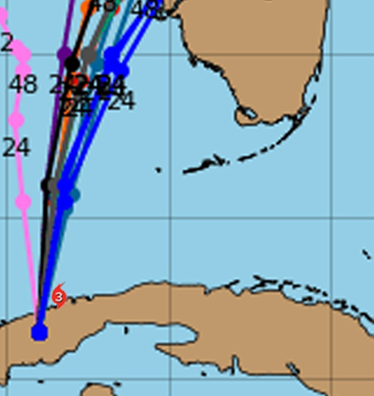
Very slightly east of the cone so far


Sent from my iPhone using Tapatalk
Sent from my iPhone using Tapatalk
1 likes
-
Blown Away
- S2K Supporter
- Posts: 10253
- Joined: Wed May 26, 2004 6:17 am
Re: ATL: IAN - Hurricane - Discussion
SFLcane wrote:Blown Away wrote:https://i.imgur.com/Mcooqnp.gif
Amazing this NE movement, little burst of acceleration in last few frames.
Yea we will have to see if its a wobble but there is certainly some eastern component right now.
I'm sure it will adjust back to @N, but this has been going on since I got to work 4 hours ago? 4 hours is not a wobble IMO.
5 likes
Hurricane Eye Experience: David 79, Irene 99, Frances 04, Jeanne 04, Wilma 05… Hurricane Brush Experience: Andrew 92, Erin 95, Floyd 99, Matthew 16, Irma 17, Ian 22, Nicole 22…

-
Jelmergraaff
- Tropical Storm
- Posts: 138
- Age: 23
- Joined: Fri Aug 27, 2021 1:00 pm
- Location: The Netherlands
Re: ATL: IAN - Hurricane - Discussion
11 AM advisory says 100kt and a minimum pressure of 963 mb. Would also have been my estimate, although I would've put the pressure a bit lower perhaps.
2 likes
21-year old meteorologist and student MSc Climate Studies from The Netherlands. Interested in all fields of meteorology and climatology, including tropical systems like hurricanes.
-
Hurricaneman
- Category 5
- Posts: 7404
- Age: 45
- Joined: Tue Aug 31, 2004 3:24 pm
- Location: central florida
Re: ATL: IAN - Hurricane - Discussion
My thoughts are the NE motion is land friction and should resume a N to NNE motion
5 likes
-
Canelaw99

- S2K Supporter
- Posts: 2128
- Age: 49
- Joined: Tue Aug 31, 2004 8:27 am
- Location: Homestead, FL
Re: ATL: IAN - Hurricane - Discussion
Blown Away wrote:https://i.imgur.com/Mcooqnp.gif
Amazing this NE movement, little burst of acceleration in last few frames.
Obviously noone can say with certainty, but what are the chances it stays on this general NE looking heading and comes in way south?
1 likes

Re: ATL: IAN - Hurricane - Discussion
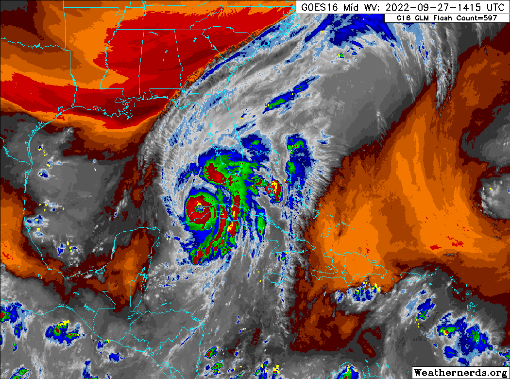
This started with the trough evolution several people spotted yesterday afternoon.
There was shear from the west digging down over NOLA.
If they are flying the special upper air analysis flights over northern GOM maybe we will get some solid data.
4 likes
-
longhorn2004
- Tropical Depression

- Posts: 61
- Joined: Fri Oct 06, 2017 1:49 pm
Re: ATL: IAN - Hurricane - Discussion
SFLcane wrote:Trof certainly digging you can see it on WV Ian will not be able to go much further north soon without being kicked out.
https://i.postimg.cc/V6zxcQTh/trof.png
Impressive. One would think Ian being sucking in drier air from the front.
1 likes
Re: ATL: IAN - Hurricane - Discussion
"The latest
forecast is adjusted to the southeast for this advisory, showing
landfall 6-12 hours faster than before, and we will have to see if
the southern trend continues in the afternoon guidance." from NHC 11am Discussion.
forecast is adjusted to the southeast for this advisory, showing
landfall 6-12 hours faster than before, and we will have to see if
the southern trend continues in the afternoon guidance." from NHC 11am Discussion.
2 likes
Who is online
Users browsing this forum: No registered users and 24 guests