ATL: IAN - Models

Moderator: S2k Moderators

Message
Author
User avatar
Meteorcane
Category 2
Category 2
Posts: 541
Joined: Thu Jul 21, 2011 6:49 am
Location: North Platte Nebraska

Re: ATL: IAN - Models

#3241 Postby Meteorcane » Tue Sep 27, 2022 1:04 pm

CronkPSU wrote:any 12z Euro updates yet?


landfalls near Englewood

Image
4 likes   

User avatar
SFLcane
S2K Supporter
S2K Supporter
Posts: 9627
Age: 46
Joined: Sat Jun 05, 2010 1:44 pm
Location: Lake Worth Florida

Re: ATL: IAN - Models

#3242 Postby SFLcane » Tue Sep 27, 2022 1:04 pm

CronkPSU wrote:any 12z Euro updates yet?


Yes into Fort Myers!!

UKMET not so crazy now lol.
4 likes   

Poonwalker
Tropical Storm
Tropical Storm
Posts: 146
Joined: Tue Sep 20, 2022 11:12 am

Re: ATL: IAN - Models

#3243 Postby Poonwalker » Tue Sep 27, 2022 1:04 pm

Much better news for Tampa in terms of surge but the cone is something we have to stay vigilant to. Ukmet is an outlier in terms of how it continues the NE track across the state showing the trough picking the storm up. The others show a collapse in steering and slow poleward progression late in the forecast. The farther south this hits the stronger the storm will be at landfall. Unfortunately this is really bad news for Port Charlotte, Naples, and Ft Myers. Obviously going to be massive surge damage there. :(
Last edited by Poonwalker on Tue Sep 27, 2022 1:06 pm, edited 2 times in total.
4 likes   

User avatar
Full8s
S2K Supporter
S2K Supporter
Posts: 44
Age: 43
Joined: Tue Aug 19, 2008 3:08 pm
Location: Hudson, Fl

Re: ATL: IAN - Models

#3244 Postby Full8s » Tue Sep 27, 2022 1:05 pm

Please forgive my relative ignorance, but can someone explain why HWRF still likes Tampa Bay for Thursday when others are making a much quicker right turn? Thanks.
2 likes   
"All I know is that I don't know nothin'..."

User avatar
SFLcane
S2K Supporter
S2K Supporter
Posts: 9627
Age: 46
Joined: Sat Jun 05, 2010 1:44 pm
Location: Lake Worth Florida

Re: ATL: IAN - Models

#3245 Postby SFLcane » Tue Sep 27, 2022 1:07 pm

:eek: :eek: :eek:

Image
2 likes   

Bimms
Tropical Low
Tropical Low
Posts: 10
Joined: Thu Jul 30, 2020 11:24 am

Re: ATL: IAN - Models

#3246 Postby Bimms » Tue Sep 27, 2022 1:08 pm

I am by no means a professional, I enjoy reading the posts here and the models and the reading the posts in the discussion threads as well, but please excuse my ignorance with this, but I've been watching these models and reading and watching the news, but why (to me at least) does the storm look like it's going to hit south of Tampa, but cross over into the extremely highly populated areas of PBC, Broward, and Dade counties in SoFlo?? is anybody else seeing that, again I admit my ignorance with this, but it looks to me as if that is a possibility.
1 likes   

User avatar
Meteorcane
Category 2
Category 2
Posts: 541
Joined: Thu Jul 21, 2011 6:49 am
Location: North Platte Nebraska

Re: ATL: IAN - Models

#3247 Postby Meteorcane » Tue Sep 27, 2022 1:08 pm

RedRiverRefuge wrote:Ignorant ? For the group. Is there ever a time near landfall that you stop watching global models (GFS/Euro) and refer instead to mesoscale such as HRRR etc or does the mesoscale not have all necessary data parameters to determine path and intensity. Thanks.


Good question... the convective-allowing models will typically struggle with tropical cyclones because they can't really handle the core dynamics well at all (that is why you will see ridiculous minimum pressures and such from the HRRR/NAM-nest etc.) and once the low-lvl wind fields get "messed up" by the unrealistic pressure gradient many other aspects of their forecast get wonky near the storm in a sort of feedback loop. That being said they can do decent with storms once they begin to transition extratropical and can often provide good QPF and peak gust forecasts (see Ida's remnants, or even Isaias a few years ago when it got to higher latitudes). You can also have boundary problems caused by the fact that the higher-res models have smaller domains, but this because less of an issue the closer in time you get to the event.
Last edited by Meteorcane on Tue Sep 27, 2022 1:10 pm, edited 1 time in total.
4 likes   

User avatar
SFLcane
S2K Supporter
S2K Supporter
Posts: 9627
Age: 46
Joined: Sat Jun 05, 2010 1:44 pm
Location: Lake Worth Florida

Re: ATL: IAN - Models

#3248 Postby SFLcane » Tue Sep 27, 2022 1:08 pm

That NHC track coming south folks!
4 likes   

User avatar
skyline385
Category 5
Category 5
Posts: 2573
Age: 33
Joined: Wed Aug 26, 2020 11:15 pm
Location: Houston TX

Re: ATL: IAN - Models

#3249 Postby skyline385 » Tue Sep 27, 2022 1:10 pm

SFLcane wrote:That NHC track coming south folks!

We are going to be in the cone tomorrow at this rate lol


Sent from my iPhone using Tapatalk
5 likes   

User avatar
SFLcane
S2K Supporter
S2K Supporter
Posts: 9627
Age: 46
Joined: Sat Jun 05, 2010 1:44 pm
Location: Lake Worth Florida

Re: ATL: IAN - Models

#3250 Postby SFLcane » Tue Sep 27, 2022 1:11 pm

skyline385 wrote:
SFLcane wrote:That NHC track coming south folks!

We are going to be in the cone tomorrow at this rate lol


Sent from my iPhone using Tapatalk


Yup, unreal to see this unfold. I am actually at work though tomorrow i am working from home. If have power. :(
1 likes   

User avatar
jdray
Category 3
Category 3
Posts: 846
Joined: Tue Aug 31, 2004 10:07 pm
Location: NE Florida

Re: ATL: IAN - Models

#3251 Postby jdray » Tue Sep 27, 2022 1:12 pm

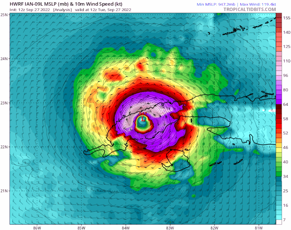
gatorcane wrote:Looks at this new wrinkle with the HWRF. Not only does it barely landfall in PInellas scraping the coast about the same place as before but look how it doesn’t actually move it NE inland now as it parallels the coast.

https://i.postimg.cc/Px3XSF0p/hwrf-mslp-wind-09-L-fh0-51.gif


That is an interesting wrinkle to throw in on the models. Some models still want to skirt the west coast, not many though.
Break out the windshield wipers now, the forecast is going to keep bouncing.
2 likes   

User avatar
skyline385
Category 5
Category 5
Posts: 2573
Age: 33
Joined: Wed Aug 26, 2020 11:15 pm
Location: Houston TX

Re: ATL: IAN - Models

#3252 Postby skyline385 » Tue Sep 27, 2022 1:12 pm

Here’s the 12Z Euro landfall

Image


Sent from my iPhone using Tapatalk
1 likes   

User avatar
eastcoastFL
Category 5
Category 5
Posts: 3438
Age: 42
Joined: Thu Apr 12, 2007 12:29 pm
Location: Palm City, FL

Re: ATL: IAN - Models

#3253 Postby eastcoastFL » Tue Sep 27, 2022 1:13 pm

Bimms wrote:I am by no means a professional, I enjoy reading the posts here and the models and the reading the posts in the discussion threads as well, but please excuse my ignorance with this, but I've been watching these models and reading and watching the news, but why (to me at least) does the storm look like it's going to hit south of Tampa, but cross over into the extremely highly populated areas of PBC, Broward, and Dade counties in SoFlo?? is anybody else seeing that, again I admit my ignorance with this, but it looks to me as if that is a possibility.


I think it would have to move almost due east for that to happen and that doesn’t appear to be in the cards. It’s most likely to move NNE to NE or due N after landfall.
2 likes   
Personal Forecast Disclaimer:
The posts in this forum are NOT official forecast and should not be used as such. They are just the opinion of the poster and may or may not be backed by sound meteorological data. They are NOT endorsed by any professional institution or storm2k.org. For official information, please refer to the NHC and NWS products.

User avatar
RedRiverRefuge
S2K Supporter
S2K Supporter
Posts: 31
Joined: Sun Feb 27, 2011 1:33 pm
Location: West Central Florida

Re: ATL: IAN - Models

#3254 Postby RedRiverRefuge » Tue Sep 27, 2022 1:15 pm

Meteorcane wrote:
RedRiverRefuge wrote:Ignorant ? For the group. Is there ever a time near landfall that you stop watching global models (GFS/Euro) and refer instead to mesoscale such as HRRR etc or does the mesoscale not have all necessary data parameters to determine path and intensity. Thanks.


Good question... the convective-allowing models will typically struggle with tropical cyclones because they can't really handle the core dynamics well at all (that is why you will see ridiculous minimum pressures and such from the HRRR/NAM-nest etc.) and once the low-lvl wind fields get "messed up" by the unrealistic pressure gradient many other aspects of their forecast get wonky near the storm in a sort of feedback loop. That being said they can do decent with storms once they begin to transition extratropical and can often provide good QPF and peak gust forecasts (see Ida's remnants, or even Isaias a few years ago when it got to higher latitudes). You can also have boundary problems caused by the fact that the higher-res models have smaller domains, but this because less of an issue the closer in time you get to the event.


Excellent explanation… thanks!
1 likes   
This post is NOT AN OFFICIAL FORECAST and should not be used as such. It is just the opinion of the poster and may or may not be backed by sound meteorological data. It is NOT endorsed by any professional institution including storm2k.org. For Official Information please refer to the NHC and NWS products

rwfromkansas
Category 5
Category 5
Posts: 2254
Joined: Sat Aug 27, 2005 12:47 am
Location: North Fort Worth

Re: ATL: IAN - Models

#3255 Postby rwfromkansas » Tue Sep 27, 2022 1:20 pm

Poor Sanibel. Many great times there as a kid. Charley v. 2.0.
1 likes   

jlauderdal
S2K Supporter
S2K Supporter
Posts: 6810
Joined: Wed May 19, 2004 5:46 am
Location: NE Fort Lauderdale
Contact:

Re: ATL: IAN - Models

#3256 Postby jlauderdal » Tue Sep 27, 2022 1:20 pm


You will have a hurricane warning sooner rather than later if this continues, the trend is not your friend at all.
5 likes   

tolakram
Admin
Admin
Posts: 19182
Age: 60
Joined: Sun Aug 27, 2006 8:23 pm
Location: Florence, KY (name is Mark)

Re: ATL: IAN - Models

#3257 Postby tolakram » Tue Sep 27, 2022 1:21 pm

12Z Euro
Image
2 likes   
M a r k
- - - - -
Join us in chat: Storm2K Chatroom Invite. Android and IOS apps also available.

The posts in this forum are NOT official forecasts and should not be used as such. Posts are NOT endorsed by any professional institution or STORM2K.org. For official information and forecasts, please refer to NHC and NWS products.

hurricaneCW
Category 5
Category 5
Posts: 1773
Joined: Wed Mar 03, 2010 6:20 am
Location: Toms River, NJ

Re: ATL: IAN - Models

#3258 Postby hurricaneCW » Tue Sep 27, 2022 1:22 pm

Landfall likely by tomorrow afternoon. Today's really the last day to prepare
1 likes   

tolakram
Admin
Admin
Posts: 19182
Age: 60
Joined: Sun Aug 27, 2006 8:23 pm
Location: Florence, KY (name is Mark)

Re: ATL: IAN - Models

#3259 Postby tolakram » Tue Sep 27, 2022 1:23 pm

As a reminder here is the observed model track skill from last year. We're at about 36 hours out.

Image
1 likes   
M a r k
- - - - -
Join us in chat: Storm2K Chatroom Invite. Android and IOS apps also available.

The posts in this forum are NOT official forecasts and should not be used as such. Posts are NOT endorsed by any professional institution or STORM2K.org. For official information and forecasts, please refer to NHC and NWS products.

tolakram
Admin
Admin
Posts: 19182
Age: 60
Joined: Sun Aug 27, 2006 8:23 pm
Location: Florence, KY (name is Mark)

Re: ATL: IAN - Models

#3260 Postby tolakram » Tue Sep 27, 2022 1:26 pm

Here is the error for Ian so far

AVNO is GFS

Image

source: https://www.atmos.albany.edu/facstaff/tang/tcguidance/
1 likes   
M a r k
- - - - -
Join us in chat: Storm2K Chatroom Invite. Android and IOS apps also available.

The posts in this forum are NOT official forecasts and should not be used as such. Posts are NOT endorsed by any professional institution or STORM2K.org. For official information and forecasts, please refer to NHC and NWS products.


Return to “2022”

Who is online

Users browsing this forum: No registered users and 8 guests