ATL: IAN - Post-Tropical - Discussion
Moderator: S2k Moderators
-
Lightning48
- Tropical Low

- Posts: 33
- Joined: Mon Mar 07, 2022 12:06 pm
Re: ATL: IAN - Hurricane - Discussion
Quick question: A Baynews9 meteorologist came on and mentioned Ian was moving in a NE direction and this will significantly change the track. I just saw the NHC 12 pm update and it’s says it’s moving North- Anybody able to remedy this confusion?
2 likes

Re: ATL: IAN - Hurricane - Discussion
Knight85 wrote:Blown Away wrote:Impressive Major Hurricane!
Do I spy a pronounced stadium effect forming on that eyewall?
This is going to look really good later this afternoon as the sun moves to the west.
Should get some nice pics from recon
5 likes
-
johngaltfla

- Category 5

- Posts: 2073
- Joined: Sun Jul 10, 2005 9:17 pm
- Location: Sarasota County, FL
- Contact:
Re: ATL: IAN - Hurricane - Discussion
Annnnnddddd I just passed the people who decided "oh crap I'd better evacuate" on the roads. Folks, it's going to be a long night for some of you, be careful out there.
5 likes
-
galaxy401

- Category 5
- Posts: 2446
- Age: 30
- Joined: Sat Aug 25, 2012 9:04 pm
- Location: Casa Grande, Arizona
Re: ATL: IAN - Hurricane - Discussion
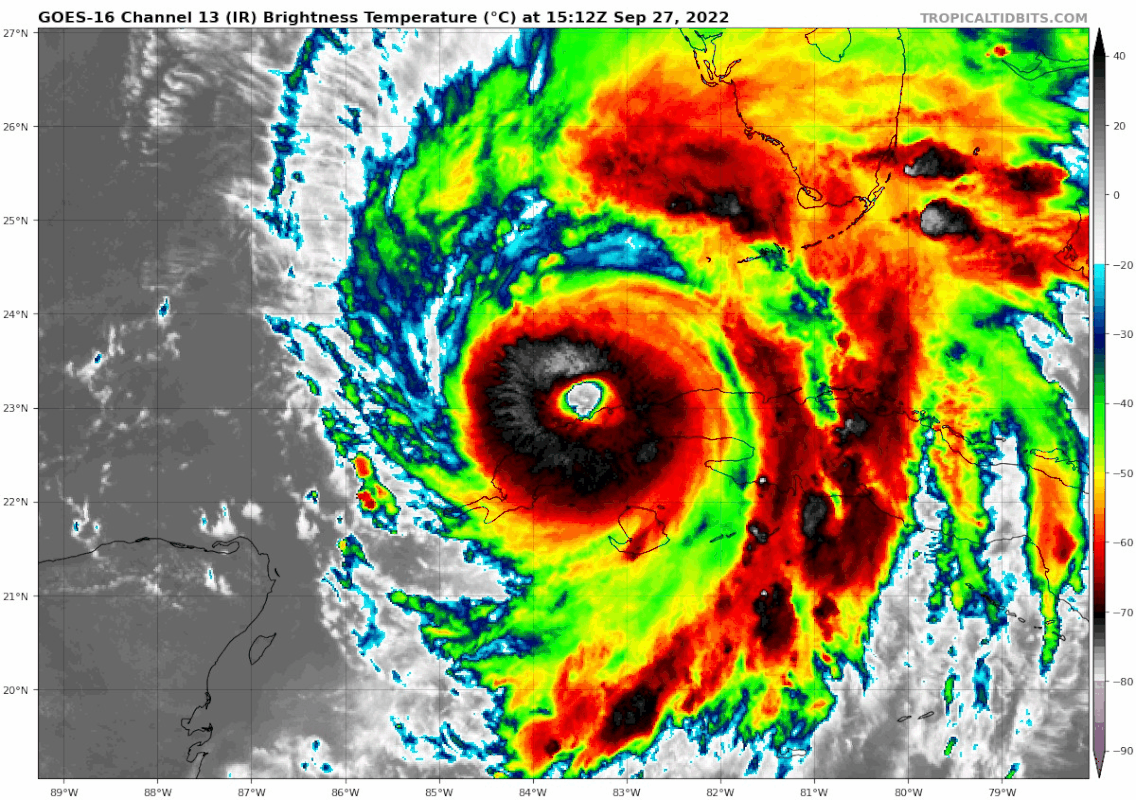
Based on its very impressive visible imagery and pressure in the 940s over land, I do think Ian reached Category 4 at landfall on Cuba.
10 likes
Got my eyes on moving right into Hurricane Alley: Florida.
-
THC_Scientist

- Tropical Wave

- Posts: 9
- Joined: Thu Sep 22, 2022 10:08 pm
Re: ATL: IAN - Hurricane - Discussion
Long time lurker, first post. Always have enjoyed your analysis and once again you’ve nailed it. I’m in zone A in Pinellas county and feel better about riding out the storm.wxman57 wrote:Once again, NHC track moved right on top of mine. With SW-W sheared storms in the Gulf, they almost always move more quickly and turn sharper east than predicted. I have it inland in the Sarasota-Venice area around sunset tomorrow (always at night). Could be south of Venice. The farther south it tracks, the stronger it will remain up to landfall. SLOSH indicates 12-14 ft where the center meets the coast. Wouldn't be anything into Tampa Bay.
1 likes
-
cycloneye

- Admin

- Posts: 149107
- Age: 69
- Joined: Thu Oct 10, 2002 10:54 am
- Location: San Juan, Puerto Rico
Re: ATL: IAN - Hurricane - Discussion
Pressure down to 961 mbs. Eye is closed.
832
URNT12 KNHC 271612
VORTEX DATA MESSAGE AL092022
A. 27/15:46:30Z
B. 23.13 deg N 083.47 deg W
C. 700 mb 2746 m
D. 961 mb
E. 115 deg 4 kt
F. CLOSED
G. C19
H. 92 kt
I. 316 deg 8 nm 15:44:00Z
J. 041 deg 82 kt
K. 315 deg 10 nm 15:43:30Z
L. 82 kt
M. 098 deg 7 nm 15:49:00Z
N. 186 deg 107 kt
O. 087 deg 15 nm 15:51:00Z
P. 7 C / 3035 m
Q. 17 C / 3052 m
R. 12 C / NA
S. 12345 / 07
T. 0.02 / 1.25 nm
U. AF302 2109A IAN OB 17
MAX FL WIND 107 KT 087 / 15 NM 15:51:00Z
;
3 likes
Visit the Caribbean-Central America Weather Thread where you can find at first post web cams,radars
and observations from Caribbean basin members Click Here
and observations from Caribbean basin members Click Here

Re: ATL: IAN - Hurricane - Discussion
the amount off lighting round the eye is incredible, unfortunately cant rule out a high end cat 4 or 5 at some point now
7 likes
-
ScottNAtlanta

- Category 5
- Posts: 2535
- Joined: Sat May 25, 2013 3:11 pm
- Location: Atlanta, GA
Re: ATL: IAN - Hurricane - Discussion
I am going to take a moment and pray for the safety and well being of everyone in the path of this storm and especially those that post regularly that are facing a very scary unknown. It's something I can do to let people know I am thinking of them in my prayers.
14 likes
The posts in this forum are NOT official forecast and should not be used as such. They are just the opinion of the poster and may or may not be backed by sound meteorological data. They are NOT endorsed by any professional institution or storm2k.org. For official information, please refer to the NHC and NWS products.
-
Iceresistance

- Category 5
- Posts: 9564
- Age: 22
- Joined: Sat Oct 10, 2020 9:45 am
- Location: Tecumseh, OK/Norman, OK
Re: ATL: IAN - Hurricane - Discussion
Recon has found 961 mb, Ian is getting stronger again.
3 likes
Bill 2015 & Beta 2020
Winter 2020-2021
All observations are in Tecumseh, OK unless otherwise noted.
Winter posts are focused mainly for Oklahoma & Texas.
Take any of my forecasts with a grain of salt, refer to the NWS, SPC, and NHC for official information
Never say Never with weather! Because ANYTHING is possible!
Winter 2020-2021
All observations are in Tecumseh, OK unless otherwise noted.
Winter posts are focused mainly for Oklahoma & Texas.
Take any of my forecasts with a grain of salt, refer to the NWS, SPC, and NHC for official information
Never say Never with weather! Because ANYTHING is possible!
Re: ATL: IAN - Hurricane - Discussion
Hurricane Ian Tropical Cyclone Update
NWS National Hurricane Center Miami FL AL092022
1200 PM EDT Tue Sep 27 2022
...12 PM EDT POSITION UPDATE OF IAN...
Radar imagery from Key West shows that the center of Ian is located
over the far southeastern Gulf of Mexico. Hourly updates of Ian's
position will continue as long as the eye is easily trackable by
land-based radar.
SUMMARY OF 1200 PM EDT...1600 UTC...INFORMATION
---------------------------------------------------
LOCATION...23.2N 83.5W
ABOUT 285 MI...460 KM SSW OF SARASOTA FLORIDA
ABOUT 110 MI...180 KM SSW OF THE DRY TORTUGAS
MAXIMUM SUSTAINED WINDS...115 MPH...185 KM/H
PRESENT MOVEMENT...N OR 5 DEGREES AT 10 MPH...17 KM/H
MINIMUM CENTRAL PRESSURE...963 MB...28.44 INCHES
$$
Forecaster Papin/Reinhart
2 likes
-
Lightning48
- Tropical Low
- Posts: 33
- Joined: Mon Mar 07, 2022 12:06 pm
Re: ATL: IAN - Hurricane - Discussion
Quick question: A Baynews9 meteorologist came on and mentioned Ian was moving in a NE direction and this will significantly change the track. I just saw the NHC 12 pm update and it’s says it’s moving North- Anybody able to remedy this confusion?
1 likes
-
Sciencerocks
- Category 5
- Posts: 10181
- Age: 40
- Joined: Thu Jul 06, 2017 1:51 am

-
SFLcane

- S2K Supporter

- Posts: 10281
- Age: 48
- Joined: Sat Jun 05, 2010 1:44 pm
- Location: Lake Worth Florida
Re: ATL: IAN - Hurricane - Discussion
My current thinking is the UKMET nailed this one asleast it sure looks that way right now I think this will come into the Fort Myers area or a tad north.
Last edited by SFLcane on Tue Sep 27, 2022 11:29 am, edited 1 time in total.
6 likes

Re: ATL: IAN - Hurricane - Discussion
SconnieCane wrote:I just got up and saw the refreshed IR loop...did Ian seriously just keep intensifying and open its eye while going over Cuba???
Keep intensifying no, open it’s eye yes.
2 likes
-
skyline385

- Category 5
- Posts: 2728
- Age: 35
- Joined: Wed Aug 26, 2020 11:15 pm
- Location: Houston TX
ATL: IAN - Hurricane - Discussion
deleted
Sent from my iPhone using Tapatalk
Sent from my iPhone using Tapatalk
Last edited by skyline385 on Tue Sep 27, 2022 11:31 am, edited 1 time in total.
2 likes
Re: ATL: IAN - Hurricane - Discussion
ScottNAtlanta wrote:I am going to take a moment and pray for the safety and well being of everyone in the path of this storm and especially those that post regularly that are facing a very scary unknown. It's something I can do to let people know I am thinking of them in my prayers.
Prayer will do nothing, only action will save people.
7 likes
Re: ATL: IAN - Hurricane - Discussion
ScottNAtlanta wrote:I am going to take a moment and pray for the safety and well being of everyone in the path of this storm and especially those that post regularly that are facing a very scary unknown. It's something I can do to let people know I am thinking of them in my prayers.
I will join you Scott....that's pretty cool of you...
7 likes
Re: ATL: IAN - Hurricane - Discussion
Lightning48 wrote:Quick question: A Baynews9 meteorologist came on and mentioned Ian was moving in a NE direction and this will significantly change the track. I just saw the NHC 12 pm update and it’s says it’s moving North- Anybody able to remedy this confusion?
It's clearly ticking east of north at a longitude that will carry it east of Tampa bay should that continue. at 83.5 longitude it does not need much easterly component to carry it inland a good bit south of here. This drastically increases the threat to southwest florida (on a shortened timeline) and reduce it up here. very grave threat to SW FL now.
6 likes
-
Iceresistance
- Category 5
- Posts: 9564
- Age: 22
- Joined: Sat Oct 10, 2020 9:45 am
- Location: Tecumseh, OK/Norman, OK
Re: ATL: IAN - Hurricane - Discussion
Fancy1001 wrote:ScottNAtlanta wrote:I am going to take a moment and pray for the safety and well being of everyone in the path of this storm and especially those that post regularly that are facing a very scary unknown. It's something I can do to let people know I am thinking of them in my prayers.
Prayer will do nothing, only action will save people.
For those who can't come to help, all you can do is pray. That is what James Spann said during the April 27th, 2011 Super Outbreak.
(Sorry for being OT Mods and Admins
6 likes
Bill 2015 & Beta 2020
Winter 2020-2021
All observations are in Tecumseh, OK unless otherwise noted.
Winter posts are focused mainly for Oklahoma & Texas.
Take any of my forecasts with a grain of salt, refer to the NWS, SPC, and NHC for official information
Never say Never with weather! Because ANYTHING is possible!
Winter 2020-2021
All observations are in Tecumseh, OK unless otherwise noted.
Winter posts are focused mainly for Oklahoma & Texas.
Take any of my forecasts with a grain of salt, refer to the NWS, SPC, and NHC for official information
Never say Never with weather! Because ANYTHING is possible!

Re: ATL: IAN - Hurricane - Discussion
Sciencerocks wrote:https://imagizer.imageshack.com/img924/710/Uh5yav.gif
I hate to say it, but this reminds me of Dorian. The incredible eyewall lightning, the incredibly clear eye, the impressive microwave presentation…this is turning into an absolute monster.
9 likes
Irene '11 Sandy '12 Hermine '16 5/15/2018 Derecho Fay '20 Isaias '20 Elsa '21 Henri '21 Ida '21
I am only a meteorology enthusiast who knows a decent amount about tropical cyclones. Look to the professional mets, the NHC, or your local weather office for the best information.
I am only a meteorology enthusiast who knows a decent amount about tropical cyclones. Look to the professional mets, the NHC, or your local weather office for the best information.
Who is online
Users browsing this forum: No registered users and 16 guests