https://twitter.com/SCwxFrankStrait/status/1573152705614598144
ATL: IAN - Post-Tropical - Discussion
Moderator: S2k Moderators
-
cycloneye

- Admin

- Posts: 149514
- Age: 69
- Joined: Thu Oct 10, 2002 10:54 am
- Location: San Juan, Puerto Rico
Re: ATL: INVEST 98L - Discussion
6 likes
Visit the Caribbean-Central America Weather Thread where you can find at first post web cams,radars
and observations from Caribbean basin members Click Here
and observations from Caribbean basin members Click Here
-
Hypercane_Kyle

- Category 5

- Posts: 3465
- Joined: Sat Mar 07, 2015 7:58 pm
- Location: Cape Canaveral, FL
Re: ATL: INVEST 98L - Discussion
This is starting to organize at a good clip now. I think it's already close to becoming a tropical depression, if not already one. I wouldn't be surprised if advisories start at 5am.

8 likes
My posts are my own personal opinion, defer to the National Hurricane Center (NHC) and other NOAA products for decision making during hurricane season.

Re: ATL: INVEST 98L - Discussion
On behalf of the entire State of Florida, you can go to hell CMC.
https://www.tropicaltidbits.com/analysi ... 92300&fh=6
https://www.tropicaltidbits.com/analysi ... 92300&fh=6
4 likes
The following post is NOT an official forecast and should not be used as such. It is just the opinion of the poster and may or may not be backed by sound meteorological data. It is NOT endorsed by any professional institution including storm2k.org For Official Information please refer to the NHC and NWS products.
Re: ATL: INVEST 98L - Discussion
Yeah, so I'm thinking the NHC probably wants to call this pretty soon, if for no other reason to start making the general public aware with official advisories. After all, there could be a genuine risk to the Keys in .. 4 days? Doesn't it take 48+ hrs to evacuate? 99% of the general public prob isn't even aware of this thing yet
5 likes
-
PandaCitrus
- Category 1

- Posts: 424
- Joined: Mon Sep 04, 2017 2:44 pm
Re: ATL: INVEST 98L - Discussion
sponger wrote:On behalf of the entire State of Florida, you can go to hell CMC.
https://www.tropicaltidbits.com/analysi ... 92300&fh=6
Yeah that's a horrible run. The property insurance market in FL is in such a precarious state right now a major hurricane hit will collapse the market. Nobody will be getting property insurance next year outside Citizens.
5 likes
Re: ATL: INVEST 98L - Discussion
sponger wrote:On behalf of the entire State of Florida, you can go to hell CMC.
https://www.tropicaltidbits.com/analysi ... 92300&fh=6
Tell that to ICON and GFS too lol
5 likes
Re: ATL: INVEST 98L - Discussion
PandaCitrus wrote:sponger wrote:On behalf of the entire State of Florida, you can go to hell CMC.
https://www.tropicaltidbits.com/analysi ... 92300&fh=6
Yeah that's a horrible run. The property insurance market in FL is in such a precarious state right now a major hurricane hit will collapse the market. Nobody will be getting property insurance next year outside Citizens.
Yep. Citizens is now writing 70% of the polices in the State.
Who is the largest insurer in Florida?
The 25 Largest Florida Homeowners Insurance Companies:
Largest Insurance Company Policies in Force
1 Universal Property and Casualty Insurance Company 577,263
2 Citizens Property Insurance Corporation 466,506
3 Security First Insurance Company 334,335
4 Federated National Insurance Company 272,335
2 likes
The following post is NOT an official forecast and should not be used as such. It is just the opinion of the poster and may or may not be backed by sound meteorological data. It is NOT endorsed by any professional institution including storm2k.org For Official Information please refer to the NHC and NWS products.
-
skyline385

- Category 5
- Posts: 2728
- Age: 35
- Joined: Wed Aug 26, 2020 11:15 pm
- Location: Houston TX
Re: ATL: INVEST 98L - Discussion
caneseddy wrote:sponger wrote:On behalf of the entire State of Florida, you can go to hell CMC.
https://www.tropicaltidbits.com/analysi ... 92300&fh=6
Tell that to ICON and GFS too lol
Yea all 3 of the 0Z runs partially or completely stalling over FL, feels like some new upper level data dump just went in for these runs.
1 likes
-
AJC3

- Admin
- Posts: 4156
- Age: 62
- Joined: Tue Aug 31, 2004 7:04 pm
- Location: Ballston Spa, New York
- Contact:
Re: ATL: INVEST 98L - Discussion
sma10 wrote: So I'm thinking the NHC probably wants to call this pretty soon, if for no other reason to start making the general public aware with official advisories. After all, there could be a genuine risk to the Keys in .. 4 days? Doesn't it take 48+ hrs to evacuate? 99% of the general public prob isn't even aware of this thing yet
The convection is persistent enough to say that It's pretty much a sheared/displaced CDO with an exposed LLC that's just waiting for the shear to subside. As long as that cold topped convection maintains itself, and I think it will, advisories are nearly a given at 5AM.
13 likes
Re: ATL: INVEST 98L - Discussion
AJC3 wrote:sma10 wrote: So I'm thinking the NHC probably wants to call this pretty soon, if for no other reason to start making the general public aware with official advisories. After all, there could be a genuine risk to the Keys in .. 4 days? Doesn't it take 48+ hrs to evacuate? 99% of the general public prob isn't even aware of this thing yet
The convection is persistent enough to say that It's pretty much a sheared/displaced CDO with an exposed LLC that's just waiting for the shear to subside. As long as that cold topped convection maintains itself, and I think it will, advisories are nearly a given at 5AM.
Agree 100%. Some of these model runs are just too risky for them to wait any longer besides. Potential of evacuations for the entire Keys and up both coasts. Ugh
2 likes
-
CrazyC83
- Professional-Met

- Posts: 34315
- Joined: Tue Mar 07, 2006 11:57 pm
- Location: Deep South, for the first time!
Re: ATL: INVEST 98L - Discussion
sma10 wrote:AJC3 wrote:sma10 wrote: So I'm thinking the NHC probably wants to call this pretty soon, if for no other reason to start making the general public aware with official advisories. After all, there could be a genuine risk to the Keys in .. 4 days? Doesn't it take 48+ hrs to evacuate? 99% of the general public prob isn't even aware of this thing yet
The convection is persistent enough to say that It's pretty much a sheared/displaced CDO with an exposed LLC that's just waiting for the shear to subside. As long as that cold topped convection maintains itself, and I think it will, advisories are nearly a given at 5AM.
Agree 100%. Some of these model runs are just too risky for them to wait any longer besides. Potential of evacuations for the entire Keys and up both coasts. Ugh
I mentioned in the models thread that we need to get extra balloon launches to determine the trough strength (having launches at 6Z and 18Z would help) and Gonzo would be of great use in the Gulf and western Caribbean. We're not in Fantasyland anymore.
10 likes

Re: ATL: INVEST 98L - Discussion
AJC3 wrote:sma10 wrote: So I'm thinking the NHC probably wants to call this pretty soon, if for no other reason to start making the general public aware with official advisories. After all, there could be a genuine risk to the Keys in .. 4 days? Doesn't it take 48+ hrs to evacuate? 99% of the general public prob isn't even aware of this thing yet
The convection is persistent enough to say that It's pretty much a sheared/displaced CDO with an exposed LLC that's just waiting for the shear to subside. As long as that cold topped convection maintains itself, and I think it will, advisories are nearly a given at 5AM.
I'm starting to think the same; far sooner then I was anticipating and a "ramp-up" that really does imply this eventual storm has some nasty intentions
1 likes
Andy D
(For official information, please refer to the NHC and NWS products.)
(For official information, please refer to the NHC and NWS products.)
-
SFLcane

- S2K Supporter

- Posts: 10281
- Age: 48
- Joined: Sat Jun 05, 2010 1:44 pm
- Location: Lake Worth Florida
Re: ATL: INVEST 98L - Discussion
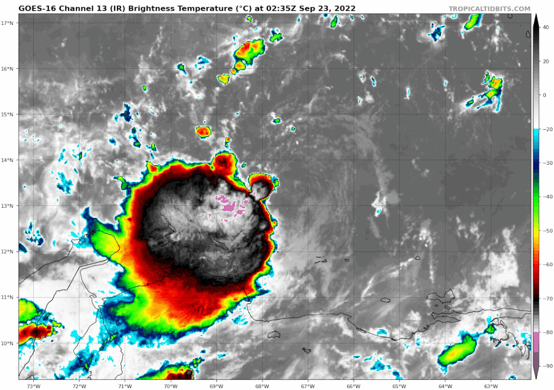
Wow as I sit here tonight looking at this IR loop I can’t shake the bad feeling I have about this storm. The circulation looks very impressive and it’s now bursting pink IR I don’t want to see what this is going to look like once it makes it into the western Caribbean.
Shear ahead it is dropping fast.
Shear ahead it is dropping fast.
4 likes
-
AtlanticWind

- S2K Supporter
- Posts: 1898
- Age: 67
- Joined: Sun Aug 08, 2004 9:57 pm
- Location: Plantation,Fla
Re: ATL: INVEST 98L - Discussion
This storm seems like it might be similar to the sept 1948 hurricane that hit Florida.
Formed near Jamaica moved north into S Florida in late September.
Formed near Jamaica moved north into S Florida in late September.
2 likes
-
Hurricaneman

- Category 5
- Posts: 7404
- Age: 45
- Joined: Tue Aug 31, 2004 3:24 pm
- Location: central florida
Re: ATL: INVEST 98L - Discussion
I’m seeing a possible relocation possibly happening under the MLC with an eddy visible outside the convection, still broad but possibly relocating under the convection
1 likes
Re: ATL: INVEST 98L - Discussion
Wonder if an early development means some of the more southern/western solutions may be back on the table. Center is going to get tugged underneath all of that convection to the west southwest.
1 likes
-
SFLcane
- S2K Supporter
- Posts: 10281
- Age: 48
- Joined: Sat Jun 05, 2010 1:44 pm
- Location: Lake Worth Florida
Re: ATL: INVEST 98L - Discussion
Hurricaneman wrote:I’m seeing a possible relocation possibly happening under the MLC with an eddy visible outside the convection, still broad but possibly relocating under the convection
Na, llc has been well established for a while now it’s been just sheared.
4 likes

Re: ATL: INVEST 98L - Discussion
Slowly feeling like a lose-lose scenario for me. Extended family lives primarily in SWFL while I'm up in Daytona; shift N or S just means either of us would be in play. Here's to hoping this doesn't get as strong as models suggest. 
5 likes
-
Stormi

- Tropical Depression

- Posts: 86
- Age: 38
- Joined: Sun Aug 18, 2019 10:04 pm
- Location: Northeast FL
Re: ATL: INVEST 98L - Discussion
Landy wrote:Slowly feeling like a lose-lose scenario for me. Extended family lives primarily in SWFL while I'm up in Daytona; shift N or S just means either of us would be in play. Here's to hoping this doesn't get as strong as models suggest.
Just take a deep breath & prep. You lose NOTHING by doing so. Could still be quite valuable over winter. Don't panic, but hurry. I'm going tmw. Does no harm being prepared, especially in given times.
6 likes


Re: ATL: INVEST 98L - Discussion
.SFLcane wrote:Hurricaneman wrote:I’m seeing a possible relocation possibly happening under the MLC with an eddy visible outside the convection, still broad but possibly relocating under the convection
Na, llc has been well established for a while now it’s been just sheared.
Just as likely is that the current convective bomb will fade and the next bomb will go off more over the current center. Then as the shear decreases another bomb will ignite over the current circulation as it gets into w carib.
Last edited by canebeard on Fri Sep 23, 2022 2:52 am, edited 1 time in total.
1 likes
List of 79 tropical cyclones intercepted by Richard Horodner:
http://www.canebeard.com/page/page/572246.htm
former storm2k screenname Beoumont 2009+
http://www.canebeard.com/page/page/572246.htm
former storm2k screenname Beoumont 2009+
Who is online
Users browsing this forum: No registered users and 22 guests