ATL: EARL - Models

Moderator: S2k Moderators

Message
Author
User avatar
kevin
Category 5
Category 5
Posts: 1771
Age: 25
Joined: Wed Aug 28, 2019 4:35 am

Re: ATL: INVEST 91L - Models

#61 Postby kevin » Sun Aug 28, 2022 11:15 am

skyline385 wrote:Well this 12Z ICON run is going to get people talking, 953mb at 180 hrs

https://s1.gifyu.com/images/icon_mslp_pcpn_watl_fh120-180.gif


Yikes, that would potentially rival the infamous D-storm from a few years ago. GFS on the other hand has a weak system (almost an open wave) at +138 hours, but it doesn't help that its initialization is absolutely terrible as well as its short-term forecast due to the (most likely) phantom WCar storm.
1 likes   

User avatar
skyline385
Category 5
Category 5
Posts: 2502
Age: 33
Joined: Wed Aug 26, 2020 11:15 pm
Location: Houston TX

Re: ATL: INVEST 91L - Models

#62 Postby skyline385 » Sun Aug 28, 2022 11:17 am

SohCahToa wrote:
skyline385 wrote:Well this 12Z ICON run is going to get people talking, 953mb at 180 hrs

https://s1.gifyu.com/images/icon_mslp_pcpn_watl_fh120-180.gif


Is that a left turn I see at the end of that run?


It is yes, waiting for it to finish loading up on weathermodels to look at the ridging.
1 likes   

User avatar
Kingarabian
S2K Supporter
S2K Supporter
Posts: 15451
Joined: Sat Aug 08, 2009 3:06 am
Location: Honolulu, Hawaii

Re: ATL: INVEST 91L - Models

#63 Postby Kingarabian » Sun Aug 28, 2022 11:23 am

Through hour 160, 12z GFS and ICON have similar tracks. CMC is further SE.
0 likes   
RIP Kobe Bryant

User avatar
skyline385
Category 5
Category 5
Posts: 2502
Age: 33
Joined: Wed Aug 26, 2020 11:15 pm
Location: Houston TX

Re: ATL: INVEST 91L - Models

#64 Postby skyline385 » Sun Aug 28, 2022 11:34 am

CMC has a complete stall to the E of Bahamas, lots of models have been hinting at some sort of steering breakdown for a while now which isn't good.
0 likes   

User avatar
gatorcane
S2K Supporter
S2K Supporter
Posts: 23499
Age: 46
Joined: Sun Mar 13, 2005 3:54 pm
Location: Boca Raton, FL

Re: ATL: INVEST 91L - Models

#65 Postby gatorcane » Sun Aug 28, 2022 11:38 am

skyline385 wrote:CMC has a complete stall to the E of Bahamas, lots of models have been hinting at some sort of steering breakdown for a while now which isn't good.


Here is the 12Z CMC animation from hours 120 to 240. Stalling might be a good thing because it could get scooped up by the next trough and shunted NE which it looks like is happening on this run (just like the 06Z GFS modeled). Would have to watch Bermuda though. Note stout ridge over top of Florida, the hurricane can’t move west because of that:

Image
3 likes   

User avatar
Meteorcane
Category 2
Category 2
Posts: 541
Joined: Thu Jul 21, 2011 6:49 am
Location: North Platte Nebraska

Re: ATL: INVEST 91L - Models

#66 Postby Meteorcane » Sun Aug 28, 2022 11:42 am

Model's still holding firm with a portion of the western Atlantic ridge retrograding SW over the FL Peninsula in about 7 days, with the system getting blocked from any westward progress, and generally weak steering beyond that. Have to hope (at least in the SE US) that that synoptic pattern holds. On the plus side despite being relatively far out it does have ensemble support with even the multi-model ensemble cluster analysis from WPC depicting some SW expansion of the ridge late next weekend.

Image
0 likes   

User avatar
gatorcane
S2K Supporter
S2K Supporter
Posts: 23499
Age: 46
Joined: Sun Mar 13, 2005 3:54 pm
Location: Boca Raton, FL

Re: ATL: INVEST 91L - Models

#67 Postby gatorcane » Sun Aug 28, 2022 11:44 am

Up and out on the 12Z GFS as it recurves without impacting land:

Image
0 likes   

User avatar
blp
Category 5
Category 5
Posts: 2807
Age: 45
Joined: Thu Sep 09, 2004 7:51 pm
Location: Miami, FL
Contact:

Re: ATL: INVEST 91L - Models

#68 Postby blp » Sun Aug 28, 2022 11:50 am

gatorcane wrote:Up and out on the 12Z GFS as it recurves without impacting land:

https://i.postimg.cc/g0MW6Cnn/gfs-z500a-Norm-watl-fh120-240.gif


You can't rely on the GFS. It is severely compromised with the continuous phantom in the NW Caribbean. That will create unrealistic upper pattern over future Danielle when its over the Bahamas.
7 likes   
The following post is NOT an official forecast and should not be used as such. It is just the opinion of the poster and may or may not be backed by sound meteorological data. It is NOT endorsed by any professional institution including storm2k.org For Official Information please refer to the NHC and NWS products.

User avatar
CFLHurricane
Category 1
Category 1
Posts: 312
Joined: Thu Mar 27, 2014 5:56 pm
Location: Floriduh

Re: ATL: INVEST 91L - Models

#69 Postby CFLHurricane » Sun Aug 28, 2022 12:16 pm

skyline385 wrote:CMC has a complete stall to the E of Bahamas, lots of models have been hinting at some sort of steering breakdown for a while now which isn't good.


This storm has fish written all over it seeing how far out to sea it is when the steering breaks down. I find it hard to believe a weakness won’t pick it up in the two days of meandering.
1 likes   
I'm not a meteorologist, but I did stay at a motel 8.

User avatar
chaser1
S2K Supporter
S2K Supporter
Posts: 4715
Age: 63
Joined: Sat Oct 15, 2005 5:59 pm
Location: Longwood, Fl

Re: ATL: INVEST 91L - Models

#70 Postby chaser1 » Sun Aug 28, 2022 12:16 pm

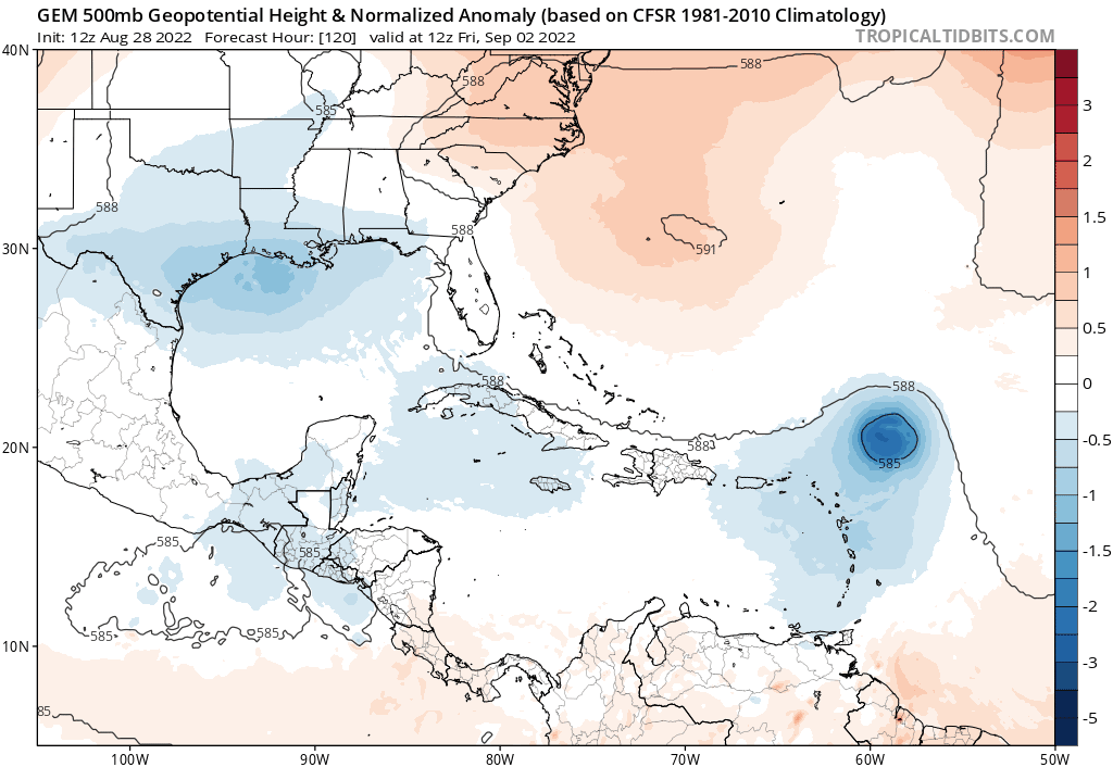
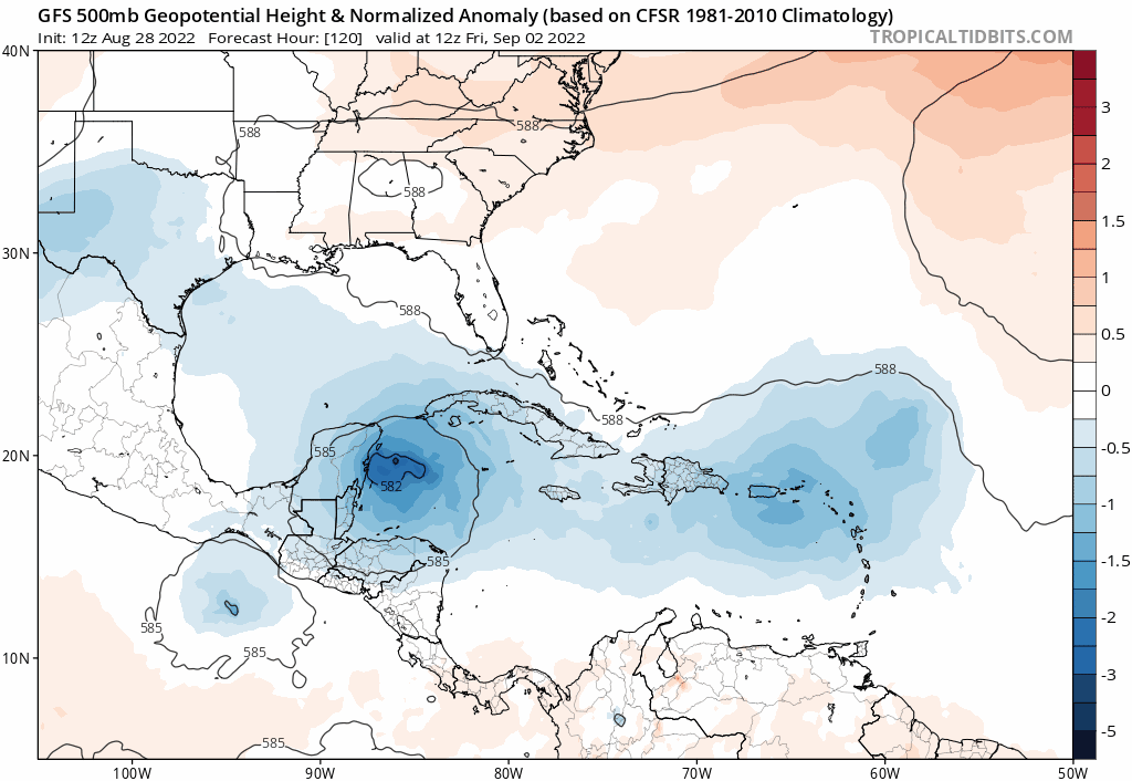
GFS seems to be the only player holding on to the SW GOM development. If a GOM tropical cyclone fails to materialize or is short lived, then I see no other influence that would suggest any southerly component of steering flow that would seem to alter a West to WNW motion in the longer term. No longer do any Global models show that odd West Atlantic "alien-grab" trough reaching southwestward and suddenly pulling 91L to the northeast. Seems like Globals (minus the GFS) are in better alignment suggesting fairly solid ridging north of the Bahamas easily up to 180 hr.'s. In fact, GFS, EURO, and CMC show no weakness showing up until at least 210 hr's where a shallow mid-level trough begins to develop in the Midwest and somehow slowly breaking down the SE CONUS ridge (in spite of progressive westerlies whipping deeper low's/troughs to the east). At least at the mid-levels, I'd say that the 500mb pattern is starting to look like....... well August LOL. I'm certainly not sold either way on any long-term intensity forecast but from a perspective of future motion and track, I am increasingly sensing that anything from a weak TD to a hurricane may be at play in "Hurricane Alley" west of 75W between 180-200 hr.s.

It will be very interesting to see during the next 2-3 days how the GFS and other models evolve (or drop) GOM development and that long range Midwest short-wave trough.
3 likes   
Personal Forecast Disclaimer:
The posts in this forum are NOT official forecast and should not be used as such. They are just the opinion of the poster and may or may not be backed by sound meteorological data. They are NOT endorsed by any professional institution or storm2k.org. For official information, please refer to the NHC and NWS products.


User avatar
cycloneye
Admin
Admin
Posts: 139327
Age: 67
Joined: Thu Oct 10, 2002 10:54 am
Location: San Juan, Puerto Rico

Re: ATL: INVEST 91L - Models

#71 Postby cycloneye » Sun Aug 28, 2022 12:26 pm

12z UKMET.

Image
0 likes   
Visit the Caribbean-Central America Weather Thread where you can find at first post web cams,radars
and observations from Caribbean basin members Click Here

User avatar
Blown Away
S2K Supporter
S2K Supporter
Posts: 9867
Joined: Wed May 26, 2004 6:17 am

Re: ATL: INVEST 91L - Models

#72 Postby Blown Away » Sun Aug 28, 2022 12:34 pm

cycloneye wrote:12z UKMET.

https://i.imgur.com/IsvYXw0.jpg


Luis, I think that is a subtle W shift in the Ukie again?
0 likes   
Hurricane Eye Experience: David 79, Irene 99, Frances 04, Jeanne 04, Wilma 05... EYE COMING MY WAY IN 2024…
Hurricane Brush Experience: Andrew 92, Erin 95, Floyd 99, Matthew 16, Irma 17, Ian 22, Nicole 22…

User avatar
skyline385
Category 5
Category 5
Posts: 2502
Age: 33
Joined: Wed Aug 26, 2020 11:15 pm
Location: Houston TX

Re: ATL: INVEST 91L - Models

#73 Postby skyline385 » Sun Aug 28, 2022 12:51 pm

Ridging on 12Z ICON

Image
0 likes   

User avatar
Kingarabian
S2K Supporter
S2K Supporter
Posts: 15451
Joined: Sat Aug 08, 2009 3:06 am
Location: Honolulu, Hawaii

Re: ATL: INVEST 91L - Models

#74 Postby Kingarabian » Sun Aug 28, 2022 12:55 pm

Euro rolling
0 likes   
RIP Kobe Bryant

Cpv17
Category 5
Category 5
Posts: 4385
Joined: Wed Dec 07, 2016 2:24 pm
Location: Wharton/El Campo, TX

Re: ATL: INVEST 91L - Models

#75 Postby Cpv17 » Sun Aug 28, 2022 1:00 pm

skyline385 wrote:Ridging on 12Z ICON

https://i.imgur.com/qYWefXH.png


I see 2 solutions here. Recurve ots or a w or wsw bend towards northern Cuba or SFL.
4 likes   

User avatar
Kingarabian
S2K Supporter
S2K Supporter
Posts: 15451
Joined: Sat Aug 08, 2009 3:06 am
Location: Honolulu, Hawaii

Re: ATL: INVEST 91L - Models

#76 Postby Kingarabian » Sun Aug 28, 2022 1:23 pm

Through the first 96 hours, GFS has less ridging than the Euro/CMC.
0 likes   
RIP Kobe Bryant

User avatar
Blown Away
S2K Supporter
S2K Supporter
Posts: 9867
Joined: Wed May 26, 2004 6:17 am

Re: ATL: INVEST 91L - Models

#77 Postby Blown Away » Sun Aug 28, 2022 1:28 pm

Image

12z ECMWF… Through 120 hrs
0 likes   
Hurricane Eye Experience: David 79, Irene 99, Frances 04, Jeanne 04, Wilma 05... EYE COMING MY WAY IN 2024…
Hurricane Brush Experience: Andrew 92, Erin 95, Floyd 99, Matthew 16, Irma 17, Ian 22, Nicole 22…

User avatar
chaser1
S2K Supporter
S2K Supporter
Posts: 4715
Age: 63
Joined: Sat Oct 15, 2005 5:59 pm
Location: Longwood, Fl

Re: ATL: INVEST 91L - Models

#78 Postby chaser1 » Sun Aug 28, 2022 1:30 pm

Cpv17 wrote:
skyline385 wrote:Ridging on 12Z ICON

https://i.imgur.com/qYWefXH.png


I see 2 solutions here. Recurve ots or a w or wsw bend towards northern Cuba or SFL.


Agreed. I believe if under 200 hr's, 91L goes W to WSW. Tough part is will it be a tropical wave or a hurricane? :ggreen:
0 likes   
Personal Forecast Disclaimer:
The posts in this forum are NOT official forecast and should not be used as such. They are just the opinion of the poster and may or may not be backed by sound meteorological data. They are NOT endorsed by any professional institution or storm2k.org. For official information, please refer to the NHC and NWS products.


BobHarlem
Category 5
Category 5
Posts: 1665
Joined: Thu Oct 20, 2005 6:11 pm

Re: ATL: INVEST 91L - Models

#79 Postby BobHarlem » Sun Aug 28, 2022 1:51 pm

Image
0 likes   

AutoPenalti
Category 5
Category 5
Posts: 3949
Age: 27
Joined: Mon Aug 17, 2015 4:16 pm
Location: Ft. Lauderdale, Florida

Re: ATL: INVEST 91L - Models

#80 Postby AutoPenalti » Sun Aug 28, 2022 1:53 pm

Looks like a N shift?
0 likes   
The posts in this forum are NOT official forecasts and should not be used as such. They are just the opinion of the poster and may or may not be backed by sound meteorological data. They are NOT endorsed by any professional institution or STORM2K. For official information, please refer to products from the NHC and NWS.


Model Runs Cheat Sheet:
GFS (5:30 AM/PM, 11:30 AM/PM)
HWRF, GFDL, UKMET, NAVGEM (6:30-8:00 AM/PM, 12:30-2:00 AM/PM)
ECMWF (1:45 AM/PM)

TCVN
is a weighted averaged


Return to “2022”

Who is online

Users browsing this forum: No registered users and 4 guests