


ATL: EARL - Post-Tropical - Discussion
Moderator: S2k Moderators
Re: ATL: EARL - Tropical Storm - Discussion
There's that dry westerly shear the Euro was advertising for days, Earl may have to wait until at least tomorrow to start strengthening again.
0 likes
Re: ATL: EARL - Tropical Storm - Discussion
aspen wrote:Pressure looks to be falling a bit again, down to the mid-990s. The next pass will go through the NE quadrant where the strongest winds probably are.
Also, despite Earl’s convective collapse overnight, recon has found that the wind and pressure gradients align even closer than during the previous flight, indicating that the MLC and LLC have gotten better stacked.
Second pass dropsonde showed only 999mb. It needs to get out of this area of dry westerly shear before it can start strengthening again. IMO.
0 likes
Re: ATL: EARL - Tropical Storm - Discussion
Looks like the LLC took a nice jog to the ENE following the sheared convection.

0 likes

Re: ATL: EARL - Tropical Storm - Discussion
The two NE quad/center passes support an intensity of 50-55kt and 997–998mb.
0 likes
Irene '11 Sandy '12 Hermine '16 5/15/2018 Derecho Fay '20 Isaias '20 Elsa '21 Henri '21 Ida '21
I am only a meteorology enthusiast who knows a decent amount about tropical cyclones. Look to the professional mets, the NHC, or your local weather office for the best information.
I am only a meteorology enthusiast who knows a decent amount about tropical cyclones. Look to the professional mets, the NHC, or your local weather office for the best information.
-
cycloneye

- Admin

- Posts: 149555
- Age: 69
- Joined: Thu Oct 10, 2002 10:54 am
- Location: San Juan, Puerto Rico
Re: ATL: EARL - Tropical Storm - Discussion
AL, 06, 2022090612, , BEST, 0, 235N, 657W, 55, 996, TS
https://ftp.nhc.noaa.gov/atcf/btk/bal062022.dat
0 likes
Visit the Caribbean-Central America Weather Thread where you can find at first post web cams,radars
and observations from Caribbean basin members Click Here
and observations from Caribbean basin members Click Here
-
cheezyWXguy

- Category 5

- Posts: 6282
- Joined: Mon Feb 13, 2006 12:29 am
- Location: Dallas, TX
Re: ATL: EARL - Tropical Storm - Discussion
Earl looks to be showing some signs of recovery this morning. Still quite ugly on IR but vis is starting to tell a different story. Guess we will see if it collapses again or if it can hold it together
0 likes
-
Sciencerocks
- Category 5
- Posts: 10186
- Age: 40
- Joined: Thu Jul 06, 2017 1:51 am

-
Iceresistance

- Category 5
- Posts: 9598
- Age: 22
- Joined: Sat Oct 10, 2020 9:45 am
- Location: Tecumseh, OK/Norman, OK
Re: ATL: EARL - Tropical Storm - Discussion
We do have AF305 on the way to Earl unless it's been forced to turn back. But it appears that there is no public data since 10 AM CDT.
0 likes
Bill 2015 & Beta 2020
Winter 2020-2021
All observations are in Tecumseh, OK unless otherwise noted.
Winter posts are focused mainly for Oklahoma & Texas.
Take any of my forecasts with a grain of salt, refer to the NWS, SPC, and NHC for official information
Never say Never with weather! Because ANYTHING is possible!
Winter 2020-2021
All observations are in Tecumseh, OK unless otherwise noted.
Winter posts are focused mainly for Oklahoma & Texas.
Take any of my forecasts with a grain of salt, refer to the NWS, SPC, and NHC for official information
Never say Never with weather! Because ANYTHING is possible!
Re: ATL: EARL - Tropical Storm - Discussion
Iceresistance wrote:We do have AF305 on the way to Earl unless it's been forced to turn back. But it appears that there is no public data since 10 AM CDT.
Data just started updating on Tropical Tidbits. They’re almost at Earl, and assuming data transmission is smooth from here on out, we should get the first center pass in the next hour.
0 likes
Irene '11 Sandy '12 Hermine '16 5/15/2018 Derecho Fay '20 Isaias '20 Elsa '21 Henri '21 Ida '21
I am only a meteorology enthusiast who knows a decent amount about tropical cyclones. Look to the professional mets, the NHC, or your local weather office for the best information.
I am only a meteorology enthusiast who knows a decent amount about tropical cyclones. Look to the professional mets, the NHC, or your local weather office for the best information.
-
InfernoFlameCat

- Category 5
- Posts: 2127
- Age: 22
- Joined: Mon Dec 14, 2020 10:52 am
- Location: Buford, GA
Re: ATL: EARL - Tropical Storm - Discussion
Earl is tightening up. Shear is gradually becoming less destructive. I think it becomes a hurricane today.
0 likes
I am by no means a professional. DO NOT look at my forecasts for official information or make decisions based on what I post.
Goal: to become a registered expert over tropical and subtropical cyclones.
Goal: to become a registered expert over tropical and subtropical cyclones.
Re: ATL: EARL - Tropical Storm - Discussion
InfernoFlameCat wrote:Earl is tightening up. Shear is gradually becoming less destructive. I think it becomes a hurricane today.
You might be right. Recon just found ~70-73kt FL winds and ~63kt SFMR winds in the northern part of the storm, and the pressure so far is down a few mbar.
0 likes
Irene '11 Sandy '12 Hermine '16 5/15/2018 Derecho Fay '20 Isaias '20 Elsa '21 Henri '21 Ida '21
I am only a meteorology enthusiast who knows a decent amount about tropical cyclones. Look to the professional mets, the NHC, or your local weather office for the best information.
I am only a meteorology enthusiast who knows a decent amount about tropical cyclones. Look to the professional mets, the NHC, or your local weather office for the best information.
-
cheezyWXguy
- Category 5
- Posts: 6282
- Joined: Mon Feb 13, 2006 12:29 am
- Location: Dallas, TX
Re: ATL: EARL - Tropical Storm - Discussion
aspen wrote:InfernoFlameCat wrote:Earl is tightening up. Shear is gradually becoming less destructive. I think it becomes a hurricane today.
You might be right. Recon just found ~70-73kt FL winds and ~63kt SFMR winds in the northern part of the storm, and the pressure so far is down a few mbar.
Was just going to post this. I’m not sure what the reduction factor is in this case, but if it’s 0.9, the FL winds just meet the threshold
0 likes

Re: ATL: EARL - Tropical Storm - Discussion
cheezyWXguy wrote:aspen wrote:InfernoFlameCat wrote:Earl is tightening up. Shear is gradually becoming less destructive. I think it becomes a hurricane today.
You might be right. Recon just found ~70-73kt FL winds and ~63kt SFMR winds in the northern part of the storm, and the pressure so far is down a few mbar.
Was just going to post this. I’m not sure what the reduction factor is in this case, but if it’s 0.9, the FL winds just meet the threshold
Very close to a hurricane again but those winds were measured in the northern quadrant.
Now that it is moving with the shear it probably won't lose its moisture again.
Doesn't look like a threat to Bermuda so hope it moves slow and keeps a weakness there to help recurve the next September CV storm.
0 likes

Re: ATL: EARL - Tropical Storm - Discussion
cheezyWXguy wrote:aspen wrote:InfernoFlameCat wrote:Earl is tightening up. Shear is gradually becoming less destructive. I think it becomes a hurricane today.
You might be right. Recon just found ~70-73kt FL winds and ~63kt SFMR winds in the northern part of the storm, and the pressure so far is down a few mbar.
Was just going to post this. I’m not sure what the reduction factor is in this case, but if it’s 0.9, the FL winds just meet the threshold
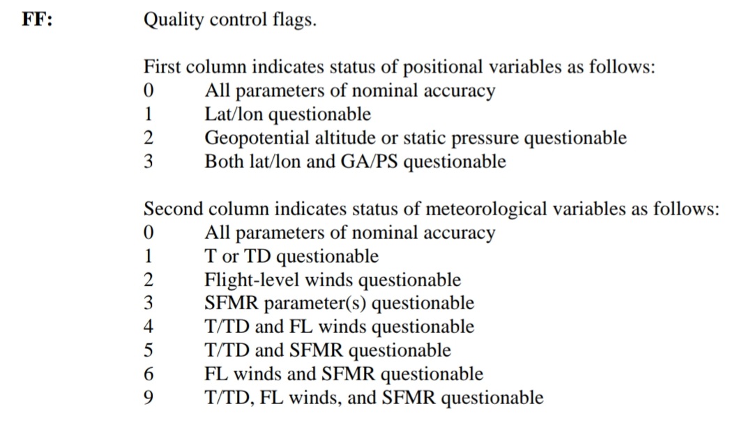
172830 2425N 06547W 8446 01462 //// +143 //// 074055 058 055 057 01
172900 2423N 06546W 8407 01499 //// +148 //// 065055 057 063 057 01
172930 2422N 06546W 8440 01457 //// +150 //// 069064 072 060 063 01
173000 2420N 06545W 8424 01472 //// +154 //// 091047 072 063 041 01
Data's flagged if you see 01/03/05 at the end (though I don't recall what specifically those correspond to)
0 likes
The above post is not official and should not be used as such. It is the opinion of the poster and may or may not be backed by sound meteorological data. It is not endorsed by any professional institution or storm2k.org. For official information, please refer to the NHC and NWS products.
-
cheezyWXguy
- Category 5
- Posts: 6282
- Joined: Mon Feb 13, 2006 12:29 am
- Location: Dallas, TX
Re: ATL: EARL - Tropical Storm - Discussion
Hammy wrote:cheezyWXguy wrote:aspen wrote:You might be right. Recon just found ~70-73kt FL winds and ~63kt SFMR winds in the northern part of the storm, and the pressure so far is down a few mbar.
Was just going to post this. I’m not sure what the reduction factor is in this case, but if it’s 0.9, the FL winds just meet the threshold172830 2425N 06547W 8446 01462 //// +143 //// 074055 058 055 057 01
172900 2423N 06546W 8407 01499 //// +148 //// 065055 057 063 057 01
172930 2422N 06546W 8440 01457 //// +150 //// 069064 072 060 063 01
173000 2420N 06545W 8424 01472 //// +154 //// 091047 072 063 041 01
Data's flagged if you see 01/03/05 at the end (though I don't recall what specifically those correspond to)
I might be misremembering, but I thought 00 and 01 were accepted while the rest were considered a suspect flag. That said, even if they are accepted, it’s probably not quite a strong enough case for the upgrade yet, but probably justifies a return to 60 kt and 993mb or so
1 likes

Re: ATL: EARL - Tropical Storm - Discussion
cheezyWXguy wrote:Hammy wrote:cheezyWXguy wrote:Was just going to post this. I’m not sure what the reduction factor is in this case, but if it’s 0.9, the FL winds just meet the threshold172830 2425N 06547W 8446 01462 //// +143 //// 074055 058 055 057 01
172900 2423N 06546W 8407 01499 //// +148 //// 065055 057 063 057 01
172930 2422N 06546W 8440 01457 //// +150 //// 069064 072 060 063 01
173000 2420N 06545W 8424 01472 //// +154 //// 091047 072 063 041 01
Data's flagged if you see 01/03/05 at the end (though I don't recall what specifically those correspond to)
I might be misremembering, but I thought 00 and 01 were accepted while the rest were considered a suspect flag. That said, even if they are accepted, it’s probably not quite a strong enough case for the upgrade yet, but probably justifies a return to 60 kt and 993mb or so
2 likes
TC naming lists: retirements and intensity
Most aggressive Advisory #1's in North Atlantic (cr. kevin for starting the list)
Most aggressive Advisory #1's in North Atlantic (cr. kevin for starting the list)
-
cycloneye
- Admin
- Posts: 149555
- Age: 69
- Joined: Thu Oct 10, 2002 10:54 am
- Location: San Juan, Puerto Rico
Re: ATL: EARL - Tropical Storm - Discussion
VDM has the 72kt.
URNT12 KNHC 061830
VORTEX DATA MESSAGE AL062022
A. 06/17:38:30Z
B. 23.90 deg N 065.72 deg W
C. 850 mb 1365 m
D. 994 mb
E. 335 deg 3 kt
F. NA
G. NA
H. 63 kt
I. 355 deg 26 nm 17:30:00Z
J. 069 deg 72 kt
K. 355 deg 27 nm 17:29:30Z
L. 47 kt
M. 136 deg 41 nm 17:56:00Z
N. 225 deg 54 kt
O. 135 deg 47 nm 17:57:30Z
P. 16 C / 1538 m
Q. 21 C / 1525 m
R. 15 C / NA
S. 1345 / 08
T. 0.02 / 2 nm
U. AF305 1306A EARL OB 06
MAX FL WIND 72 KT 355 / 27 NM 17:29:30Z
0 likes
Visit the Caribbean-Central America Weather Thread where you can find at first post web cams,radars
and observations from Caribbean basin members Click Here
and observations from Caribbean basin members Click Here
Re: ATL: EARL - Tropical Storm - Discussion
0 likes
The above post is not official and should not be used as such. It is the opinion of the poster and may or may not be backed by sound meteorological data. It is not endorsed by any professional institution or storm2k.org. For official information, please refer to the NHC and NWS products.

Re: ATL: EARL - Tropical Storm - Discussion
191330 2404N 06549W 8427 01418 9899 +213 +162 004004 006 015 002 00
0 likes
-
ElectricStorm

- Category 5
- Posts: 5148
- Age: 25
- Joined: Tue Aug 13, 2019 11:23 pm
- Location: Norman, OK
Re: ATL: EARL - Tropical Storm - Discussion
990mb extrap this pass
0 likes
B.S Meteorology, University of Oklahoma '25
Please refer to the NHC, NWS, or SPC for official information.
Please refer to the NHC, NWS, or SPC for official information.
Who is online
Users browsing this forum: No registered users and 16 guests