

ATL: IAN - Models
Moderator: S2k Moderators
Re: ATL: INVEST 98L - Models
HWRF is trying to sneak this through the Yucatan Channel. This kind of track has the highest intensity ceiling and would give 98L a little more time for RI before running into shear (mentioned by wxman57) that should weaken it ahead of a CONUS landfall.
1 likes
Irene '11 Sandy '12 Hermine '16 5/15/2018 Derecho Fay '20 Isaias '20 Elsa '21 Henri '21 Ida '21
I am only a meteorology enthusiast who knows a decent amount about tropical cyclones. Look to the professional mets, the NHC, or your local weather office for the best information.
I am only a meteorology enthusiast who knows a decent amount about tropical cyclones. Look to the professional mets, the NHC, or your local weather office for the best information.
Re: ATL: INVEST 98L - Models
hurricaneCW wrote:wx98 wrote:ncapps wrote:Euros gonna have a fish storm before we know it.
Technically it won't be a fish. Kinda impossible once something is in the Caribbean. However, yes it could be an OTS storm relative to CONUS.
Hard to believe it would miss Florida completely given its starting position.
Also strong high building over it so I don't see it hitting Florida and getting swept OTS either.
I also don't. I just specificied "could".
0 likes
-
Blown Away

- S2K Supporter

- Posts: 10253
- Joined: Wed May 26, 2004 6:17 am
Re: ATL: INVEST 98L - Models

12z ECMWF... 144 Hours Hurricane landfall Keys/Everglades City moving NNE into the Florida Peninsula
0 likes
Hurricane Eye Experience: David 79, Irene 99, Frances 04, Jeanne 04, Wilma 05… Hurricane Brush Experience: Andrew 92, Erin 95, Floyd 99, Matthew 16, Irma 17, Ian 22, Nicole 22…
-
jlauderdal
- S2K Supporter
- Posts: 7240
- Joined: Wed May 19, 2004 5:46 am
- Location: NE Fort Lauderdale
- Contact:
Re: ATL: INVEST 98L - Models
Blown Away wrote:https://i.imgur.com/kF0J2U5.gif
12z ECMWF... 120 Hours strong hurricane moving NNW over Cuba towards SFL
TVCN will come to the right, it seems we are back to where we were a few days ago with a big trend east today...take a break and check out your supplies, gfs happy hour should be interesting.
Genny owners:
Make sure you have at least 1 spare spark plug and oil. Oil changes are more frequent than you might think so check your manual. Start it today, let it run for 20 mins under some load.
1 likes
-
SouthFLTropics

- Category 5

- Posts: 4258
- Age: 50
- Joined: Thu Aug 14, 2003 8:04 am
- Location: Port St. Lucie, Florida
Re: ATL: INVEST 98L - Models
120 to 144 Hours Euro... Putting all of South Florida from Jupiter to the Keys on the dirty side of the storm.
0 likes
Fourth Generation Florida Native
Personal Storm History: David 79, Andrew 92, Erin 95, Floyd 99, Irene 99, Frances 04, Jeanne 04, Wilma 05, Matthew 16, Irma 17, Ian 22, Nicole 22, Milton 24
Personal Storm History: David 79, Andrew 92, Erin 95, Floyd 99, Irene 99, Frances 04, Jeanne 04, Wilma 05, Matthew 16, Irma 17, Ian 22, Nicole 22, Milton 24
-
Blown Away
- S2K Supporter
- Posts: 10253
- Joined: Wed May 26, 2004 6:17 am
Re: ATL: INVEST 98L - Models

12z ECMWF... Big E shift... Landfall Keys/Everglades City and exits near Jupiter Florida... Probably Cat 2/3
0 likes
Hurricane Eye Experience: David 79, Irene 99, Frances 04, Jeanne 04, Wilma 05… Hurricane Brush Experience: Andrew 92, Erin 95, Floyd 99, Matthew 16, Irma 17, Ian 22, Nicole 22…

-
skyline385

- Category 5
- Posts: 2728
- Age: 35
- Joined: Wed Aug 26, 2020 11:15 pm
- Location: Houston TX
ATL: INVEST 98L - Models
Blown Away wrote:
12z ECMWF... Big E shift... Landfall Keys/Everglades City and exits near Jupiter Florida... Probably Cat 2/3
Right on top of me in Jupiter lol
Sent from my iPhone using Tapatalk
0 likes
-
Blown Away
- S2K Supporter
- Posts: 10253
- Joined: Wed May 26, 2004 6:17 am
Re: ATL: INVEST 98L - Models

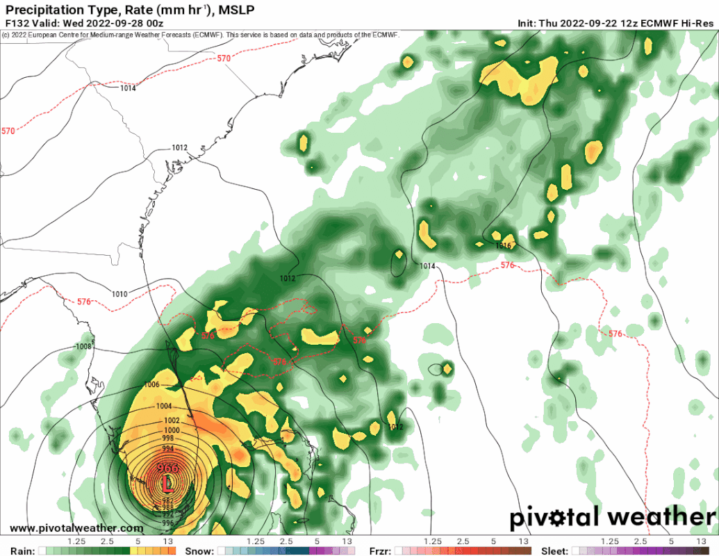
12z ECMWF
Last edited by Blown Away on Thu Sep 22, 2022 1:39 pm, edited 1 time in total.
0 likes
Hurricane Eye Experience: David 79, Irene 99, Frances 04, Jeanne 04, Wilma 05… Hurricane Brush Experience: Andrew 92, Erin 95, Floyd 99, Matthew 16, Irma 17, Ian 22, Nicole 22…
-
TheHurricaneGod
- Tropical Storm

- Posts: 165
- Age: 23
- Joined: Thu Apr 16, 2020 6:19 pm
- Location: Fort Lauderdale

Re: ATL: INVEST 98L - Models
shah83 wrote:Euro is almost exactly the CMC run. This is about that super-deep trough...
The position of the 500mb heights on both models is just about the same and the proximity of the system to the trough is about the same.
0 likes

Re: ATL: INVEST 98L - Models
Have to see if east trends continue. Possible it misses S FL and scoots thru Bahamas with stronger trough.
2 likes
Re: ATL: INVEST 98L - Models
The EURO is one or 2 runs from missing all of FL to the east!. Still time for that solution to evolve. or for that to evolve and then flip back! Clarity from club NHC will be most helpful.
1 likes
-
SouthFLTropics
- Category 5
- Posts: 4258
- Age: 50
- Joined: Thu Aug 14, 2003 8:04 am
- Location: Port St. Lucie, Florida
Re: ATL: INVEST 98L - Models
SFLcane wrote:This is within 5 days Holy smokes!
Get ready for the South Florida media hype to start at 5:00 PM today. I'll bet the lines at the gas stations are going to start getting crazy within the next day or so. It will be interesting to see the ensembles and also to see if the 18z GFS comes east again.
2 likes
Fourth Generation Florida Native
Personal Storm History: David 79, Andrew 92, Erin 95, Floyd 99, Irene 99, Frances 04, Jeanne 04, Wilma 05, Matthew 16, Irma 17, Ian 22, Nicole 22, Milton 24
Personal Storm History: David 79, Andrew 92, Erin 95, Floyd 99, Irene 99, Frances 04, Jeanne 04, Wilma 05, Matthew 16, Irma 17, Ian 22, Nicole 22, Milton 24
-
Iceresistance

- Category 5
- Posts: 9592
- Age: 22
- Joined: Sat Oct 10, 2020 9:45 am
- Location: Tecumseh, OK/Norman, OK
Re: ATL: INVEST 98L - Models
The GEFS did not shift east very much if at all.

https://s5.gifyu.com/images/98L_gefs_9.22.2022-at-12z.png
https://s5.gifyu.com/images/98L_gefs_9.22.2022-at-12z.png
1 likes
Bill 2015 & Beta 2020
Winter 2020-2021
All observations are in Tecumseh, OK unless otherwise noted.
Winter posts are focused mainly for Oklahoma & Texas.
Take any of my forecasts with a grain of salt, refer to the NWS, SPC, and NHC for official information
Never say Never with weather! Because ANYTHING is possible!
Winter 2020-2021
All observations are in Tecumseh, OK unless otherwise noted.
Winter posts are focused mainly for Oklahoma & Texas.
Take any of my forecasts with a grain of salt, refer to the NWS, SPC, and NHC for official information
Never say Never with weather! Because ANYTHING is possible!

Re: ATL: INVEST 98L - Models
Iceresistance wrote:The GEFS did not shift east very much if at all.
https://s5.gifyu.com/images/98L_gefs_9.22.2022-at-12z.png
https://s5.gifyu.com/images/98L_gefs_9.22.2022-at-12z.png
No, it didn't. And being ensembles versus operational runs, I still pause a bit when watching the CMC and the Euro.
0 likes
Personal Forecast Disclaimer:
The posts in this forum are NOT official forecast and should not be used as such. They are just the opinion of the poster and may or may not be backed by sound meteorological data. They are NOT endorsed by any professional institution or storm2k.org. For official information, please refer to the NHC and NWS products.
The posts in this forum are NOT official forecast and should not be used as such. They are just the opinion of the poster and may or may not be backed by sound meteorological data. They are NOT endorsed by any professional institution or storm2k.org. For official information, please refer to the NHC and NWS products.
-
SouthFLTropics
- Category 5
- Posts: 4258
- Age: 50
- Joined: Thu Aug 14, 2003 8:04 am
- Location: Port St. Lucie, Florida
Re: ATL: INVEST 98L - Models
Long range Euro at 192 hours about to give Nova Scotia another big hit after Fiona. I didn't have Nova Scotia as a hot spot on my 2022 hurricane season bingo card.
4 likes
Fourth Generation Florida Native
Personal Storm History: David 79, Andrew 92, Erin 95, Floyd 99, Irene 99, Frances 04, Jeanne 04, Wilma 05, Matthew 16, Irma 17, Ian 22, Nicole 22, Milton 24
Personal Storm History: David 79, Andrew 92, Erin 95, Floyd 99, Irene 99, Frances 04, Jeanne 04, Wilma 05, Matthew 16, Irma 17, Ian 22, Nicole 22, Milton 24
-
AnnularCane

- S2K Supporter
- Posts: 2962
- Joined: Thu Jun 08, 2006 9:18 am
- Location: Wytheville, VA
Re: ATL: INVEST 98L - Models
Iceresistance wrote:The GEFS did not shift east very much if at all.
https://s5.gifyu.com/images/98L_gefs_9.22.2022-at-12z.png
https://s5.gifyu.com/images/98L_gefs_9.22.2022-at-12z.png
Any reason why that black line keeps making some weird loop at the end?
0 likes
"But it never rained rain. It never snowed snow. And it never blew just wind. It rained things like soup and juice. It snowed mashed potatoes and green peas. And sometimes the wind blew in storms of hamburgers." -- Judi Barrett, Cloudy with a Chance of Meatballs
-
Iceresistance
- Category 5
- Posts: 9592
- Age: 22
- Joined: Sat Oct 10, 2020 9:45 am
- Location: Tecumseh, OK/Norman, OK
Re: ATL: INVEST 98L - Models
AnnularCane wrote:Iceresistance wrote:The GEFS did not shift east very much if at all.
https://s5.gifyu.com/images/98L_gefs_9.22.2022-at-12z.png
https://s5.gifyu.com/images/98L_gefs_9.22.2022-at-12z.png
Any reason why that black line keeps making some weird loop at the end?
Expected to stall in the GoM
1 likes
Bill 2015 & Beta 2020
Winter 2020-2021
All observations are in Tecumseh, OK unless otherwise noted.
Winter posts are focused mainly for Oklahoma & Texas.
Take any of my forecasts with a grain of salt, refer to the NWS, SPC, and NHC for official information
Never say Never with weather! Because ANYTHING is possible!
Winter 2020-2021
All observations are in Tecumseh, OK unless otherwise noted.
Winter posts are focused mainly for Oklahoma & Texas.
Take any of my forecasts with a grain of salt, refer to the NWS, SPC, and NHC for official information
Never say Never with weather! Because ANYTHING is possible!
Who is online
Users browsing this forum: No registered users and 27 guests