WPAC: MALAKAS - Post-Tropical

Moderator: S2k Moderators

Message
Author
User avatar
Yellow Evan
Professional-Met
Professional-Met
Posts: 15951
Age: 25
Joined: Fri Jul 15, 2011 12:48 pm
Location: Henderson, Nevada/Honolulu, HI
Contact:

Re: WPAC: MALAKAS - Tropical Storm

#61 Postby Yellow Evan » Mon Apr 11, 2022 3:56 pm

Image

After days of struggling, Malakas is finally ripe to intensify. A large ULAC has allowed for excellent ventilation over the system. Very cold cloud tops have persisted over the system for several days, which has resulted in latent heat release that yielded to a very divergent environment aloft and prompt the ULAC to expand/become more aligned with Malakas. The CDO has contracted and steadily become more organized over the last day or so, and it’s likely that an inner core is forming. Rapid intensification looks likely for another 24-36 hours. This is probably a hurricane now and is on track to become a major hurricane.
1 likes   

User avatar
Kingarabian
S2K Supporter
S2K Supporter
Posts: 15432
Joined: Sat Aug 08, 2009 3:06 am
Location: Honolulu, Hawaii

Re: WPAC: MALAKAS - Tropical Storm

#62 Postby Kingarabian » Mon Apr 11, 2022 4:27 pm

Maybe it has hurricane force winds considering the persistent and super cold cloud tops it has maintained. But its inner structure continues to be disorganized likely due to all that dry air. Could easily still be a tropical storm. Seen tropical storms with much better defined cores than this.
5 hours ago:
Image

2 hours ago:
Image
0 likes   
RIP Kobe Bryant

User avatar
Yellow Evan
Professional-Met
Professional-Met
Posts: 15951
Age: 25
Joined: Fri Jul 15, 2011 12:48 pm
Location: Henderson, Nevada/Honolulu, HI
Contact:

Re: WPAC: MALAKAS - Tropical Storm

#63 Postby Yellow Evan » Mon Apr 11, 2022 4:46 pm

Kingarabian wrote:Maybe it has hurricane force winds considering the persistent and super cold cloud tops it has maintained. But its inner structure continues to be disorganized likely due to all that dry air. Could easily still be a tropical storm. Seen tropical storms with much better defined cores than this.
5 hours ago:
https://i.imgur.com/6fOSq3H.png

2 hours ago:
https://i.imgur.com/CSvLAw3.png


Image

Definitely further progressed than earlier though. While not complete to its south, there is a clear broad core at low levels though it needs to solidify if it wants to even try to clear an eye.
0 likes   

Sciencerocks
Category 5
Category 5
Posts: 7282
Age: 38
Joined: Thu Jul 06, 2017 1:51 am

Re: WPAC: MALAKAS - Tropical Storm

#64 Postby Sciencerocks » Mon Apr 11, 2022 5:20 pm

Image
0 likes   

User avatar
aspen
Category 5
Category 5
Posts: 8056
Joined: Sat Oct 12, 2019 7:10 pm
Location: Connecticut, USA

Re: WPAC: MALAKAS - Tropical Storm

#65 Postby aspen » Mon Apr 11, 2022 5:41 pm

Yellow Evan wrote:
Kingarabian wrote:Maybe it has hurricane force winds considering the persistent and super cold cloud tops it has maintained. But its inner structure continues to be disorganized likely due to all that dry air. Could easily still be a tropical storm. Seen tropical storms with much better defined cores than this.
5 hours ago:
https://i.imgur.com/6fOSq3H.png

2 hours ago:
https://i.imgur.com/CSvLAw3.png


https://media.discordapp.net/attachments/733552978572869632/963135190752976986/image1.jpg

Definitely further progressed than earlier though. While not complete to its south, there is a clear broad core at low levels though it needs to solidify if it wants to even try to clear an eye.

A pair of rotating hot towers has developed over the core during the last hour or so, indicating the eyewall might finally be closing off.
0 likes   
Irene '11 Sandy '12 Hermine '16 5/15/2018 Derecho Fay '20 Isaias '20 Elsa '21 Henri '21 Ida '21

I am only a meteorology enthusiast who knows a decent amount about tropical cyclones. Look to the professional mets, the NHC, or your local weather office for the best information.

User avatar
Kingarabian
S2K Supporter
S2K Supporter
Posts: 15432
Joined: Sat Aug 08, 2009 3:06 am
Location: Honolulu, Hawaii

Re: WPAC: MALAKAS - Tropical Storm

#66 Postby Kingarabian » Mon Apr 11, 2022 6:18 pm

Confusing storm. Lower levels the eyewall looks solid but as you go up it gets progressively worse.

Image
0 likes   
RIP Kobe Bryant

Sciencerocks
Category 5
Category 5
Posts: 7282
Age: 38
Joined: Thu Jul 06, 2017 1:51 am

Re: WPAC: MALAKAS - Tropical Storm

#67 Postby Sciencerocks » Mon Apr 11, 2022 6:45 pm

Image
0 likes   

User avatar
mrbagyo
Category 5
Category 5
Posts: 3614
Age: 31
Joined: Thu Apr 12, 2012 9:18 am
Location: 14.13N 120.98E
Contact:

Re: WPAC: MALAKAS - Tropical Storm

#68 Postby mrbagyo » Mon Apr 11, 2022 6:53 pm

what an ugly system.
0 likes   
The posts in this forum are NOT official forecast and should not be used as such. They are just the opinion of the poster and may or may not be backed by sound meteorological data. They are NOT endorsed by any professional institution or storm2k.org. For official information, please refer to RSMC, NHC and NWS products.

User avatar
aspen
Category 5
Category 5
Posts: 8056
Joined: Sat Oct 12, 2019 7:10 pm
Location: Connecticut, USA

Re: WPAC: MALAKAS - Tropical Storm

#69 Postby aspen » Mon Apr 11, 2022 7:38 pm

It still seems like there's a dry tongue trying to get into the core, but this is the best Malakas has looked so far. Not too shabby, just your typical large, low-end hurricane with a mid-level eye.
Image

It is so nice having Tropical Tidbit loops for WPac storms now.
0 likes   
Irene '11 Sandy '12 Hermine '16 5/15/2018 Derecho Fay '20 Isaias '20 Elsa '21 Henri '21 Ida '21

I am only a meteorology enthusiast who knows a decent amount about tropical cyclones. Look to the professional mets, the NHC, or your local weather office for the best information.

User avatar
Yellow Evan
Professional-Met
Professional-Met
Posts: 15951
Age: 25
Joined: Fri Jul 15, 2011 12:48 pm
Location: Henderson, Nevada/Honolulu, HI
Contact:

Re: WPAC: MALAKAS - Tropical Storm

#70 Postby Yellow Evan » Mon Apr 11, 2022 8:01 pm

mrbagyo wrote:what an ugly system.


Can’t tell if this is sarcasm. It’s as photogenic as you can get for a storm of this intensity thanks to its excellent outflow.
Last edited by Yellow Evan on Mon Apr 11, 2022 11:56 pm, edited 1 time in total.
1 likes   

User avatar
Yellow Evan
Professional-Met
Professional-Met
Posts: 15951
Age: 25
Joined: Fri Jul 15, 2011 12:48 pm
Location: Henderson, Nevada/Honolulu, HI
Contact:

Re: WPAC: MALAKAS - Tropical Storm

#71 Postby Yellow Evan » Mon Apr 11, 2022 8:04 pm

Image

Eye clearing attempt #1. Might not succeed but it shouldn’t be too long before we get an attempt that does.
1 likes   

User avatar
Yellow Evan
Professional-Met
Professional-Met
Posts: 15951
Age: 25
Joined: Fri Jul 15, 2011 12:48 pm
Location: Henderson, Nevada/Honolulu, HI
Contact:

Re: WPAC: MALAKAS - Tropical Storm

#72 Postby Yellow Evan » Mon Apr 11, 2022 8:22 pm

TPPN10 PGTW 120020

A. TYPHOON 02W (MALAKAS)

B. 11/2350Z

C. 15.42N

D. 134.98E

E. FIVE/HMWRI8

F. T4.0/4.0/D0.5/24HRS STT: S0.0/03HRS

G. IR/EIR

H. REMARKS: 46A/PBO EMBD CNTR/ANMTN. LLCC EMBEDDED IN LG YIELDS A
DT OF 4.5. MET/PT IS 4.0. DBO PT.

I. ADDITIONAL POSITIONS: NONE


MARTIN
0 likes   

User avatar
cycloneye
Admin
Admin
Posts: 139025
Age: 67
Joined: Thu Oct 10, 2002 10:54 am
Location: San Juan, Puerto Rico

Re: WPAC: MALAKAS - Typhoon

#73 Postby cycloneye » Mon Apr 11, 2022 8:31 pm

JMA finnally upgrades.

Issued at 2022/04/12 00:50 UTC
Analisys at 04/12 00 UTC
Category TY
Scale Large
Intensity Strong
Center Position N15°30′(15.5°)
E135°10′(135.2°)
Direction and speed of movement NNW 20km/h(10kt)
Central pressure 975hPa
Maximum wind speed near the center 35m/s(65kt)
Maximum wind gust speed 50m/s(95kt)
50-kt wind area WIDE85km(45NM)
30-kt wind area N600km(325NM)
S560km(300NM)
0 likes   
Visit the Caribbean-Central America Weather Thread where you can find at first post web cams,radars
and observations from Caribbean basin members Click Here

User avatar
Yellow Evan
Professional-Met
Professional-Met
Posts: 15951
Age: 25
Joined: Fri Jul 15, 2011 12:48 pm
Location: Henderson, Nevada/Honolulu, HI
Contact:

Re: WPAC: MALAKAS - Typhoon

#74 Postby Yellow Evan » Mon Apr 11, 2022 8:34 pm

TXPQ22 KNES 120025
TCSWNP

A. 02W (MALAKAS)

B. 11/2330Z

C. 15.4N

D. 135.3E

E. THREE/HIMAWARI-8

F. T4.5/4.5

G. IR/EIR/VIS/SSMIS

H. REMARKS...LLCC EMBEDDED IN LG RESULTS IN A DT OF 4.5. MET=5.0 AND
PT=4.5. FT IS BASED ON DT.

I. ADDL POSITIONS

11/2108Z 15.1N 135.3E SSMIS


...KONON
0 likes   

User avatar
cycloneye
Admin
Admin
Posts: 139025
Age: 67
Joined: Thu Oct 10, 2002 10:54 am
Location: San Juan, Puerto Rico

Re: WPAC: MALAKAS - Typhoon

#75 Postby cycloneye » Mon Apr 11, 2022 9:27 pm

Eye trying to clear.

Image
1 likes   
Visit the Caribbean-Central America Weather Thread where you can find at first post web cams,radars
and observations from Caribbean basin members Click Here

Hurricane2021
Tropical Storm
Tropical Storm
Posts: 108
Age: 31
Joined: Mon Jul 05, 2021 2:54 pm
Contact:

Re: WPAC: MALAKAS - Typhoon

#76 Postby Hurricane2021 » Mon Apr 11, 2022 10:14 pm

JTWC's prognostic reasoning

WDPN31 PGTW 120300
MSGID/GENADMIN/JOINT TYPHOON WRNCEN PEARL HARBOR HI//
SUBJ/PROGNOSTIC REASONING FOR TYPHOON 02W (MALAKAS) WARNING NR 021//
RMKS/
1. FOR METEOROLOGISTS.
2. 6 HOUR SUMMARY AND ANALYSIS.

SUMMARY:
INITIAL POSITION: 15.4N 135.2E
INITIAL INTENSITY: 70 KTS
GEOGRAPHIC REFERENCE: 393 NM NORTH-NORTHWEST OF YAP
MOVEMENT PAST 6 HOURS: NORTH-NORTHWESTWARD AT 10 KTS
SIGNIFICANT WAVE HEIGHT: 28 FEET

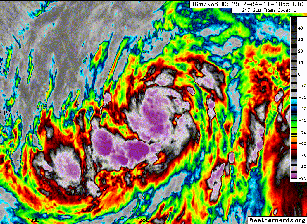
SATELLITE ANALYSIS, INITIAL POSITION AND INTENSITY DISCUSSION:
ANIMATED VISIBLE SATELLITE IMAGERY DEPICTS SPIRAL
CURVED BANDING WRAPPING INTO AN INCREASINGLY WELL DEFINED
CONVECTIVE CORE. SHORTLY AFTER THE 00Z SYNOPTIC HOUR, A FORMATIVE
CLOUD-FILLED EYE APPEARED, WITH TOWERING CONVECTION WRAPPING AROUND
THE CORE INDICATING THAT A LONG-AWAITED RAPID INTESNIFICATION MAY
FINALLY BE STARTING. THE INITIAL POSITION WAS BASED ON A BLEND OF
AGENCY FIXES FROM PGTW, RJTD, AND RCTP, AND SUPPORTED BY A LOW
RESOLUTION 112232Z NOAA-19 AMSU PASS WITH A BANDED CENTER. THE
INTENSITY WAS RAISED TO 70 KNOTS AT THE SYNOPTIC TIME, WITH
SUBJECTIVE DVORAK ESTIMATES RANGING FROM 65 TO 77 KNOTS BASED ON
FINAL-T VALUES OF T4.0 (PGTW AND RJTD) TO T4.5 (RCTP AND KNES). ADT
AND SATCON ARE ON THE LOWER END OF THE ENVELOPE AT 59 TO 62 KNOTS,
RESPECTIVELY, WHILE AIDT WAS 69 KNOTS AND THE MULTI-PLATFORM
SATELLITE WIND ANALYSIS WAS 75 KNOTS. AN 112053Z SMAP PASS WAS
SURPRISNGLY LOW AT 50 KNOTS, BUT PROVIDED A BASIS FOR THE 35 KNOT
WIND RADII ASSESSMENT. TYPHOON MALAKAS IS ROUNDING A SUB-TROPICAL
STEERING RIDGE CENTERED TO THE EAST. UPPER LEVEL WINDS ARE
GENERALLY LIGHT AND IN PHASE WITH THE STEERING MOTION, AND
DUAL-CHANNEL OUTFLOW CONTINUES TO IMPROVE AS THE NORTHERN EXTENT OF
O2W NEARS THE MID-LATITUDE JET. SEA SURFACE TEMPERATURES ARE
ESTIMATED TO BE AROUND 28 DEGREES CELSIUS. THESE FACTORS ARE
POSITIVE FOR FURTHER DEVELOPMENT.

INITIAL WIND RADII BASIS: SMAP AND SCATTEROMETER DATA

CURRENT STEERING MECHANISM: DEEP LAYER SUB-TROPICAL RIDGE (STR) TO
THE EAST

AGENCY DVORAK AND AUTOMATED FIXES:
PGTW: T4.0 - 65 KTS
RJTD: T4.0 - 65 KTS
RCTP: T4.5 - 77 KTS
KNES: T4.5 - 77 KTS
CIMSS SATCON: 59 KTS AT 112233Z
CIMSS ADT: 59 KTS AT 112340Z

FORECASTER ASSESSMENT OF CURRENT ENVIRONMENT: HIGHLY FAVORABLE
VWS: 0-5 KTS
SST: 27-28 CELSIUS
OUTFLOW: MODERATE DUAL-CHANNEL

ANALYSIS CONFIDENCE:
INITIAL POSITION: MEDIUM
INITIAL INTENSITY: MEDIUM
INITIAL WIND RADII: HIGH

3. FORECAST REASONING.

SIGNIFICANT FORECAST CHANGES: THERE ARE NO SIGNIFICANT CHANGES TO
THE FORECAST FROM THE PREVIOUS WARNING.

FORECAST DISCUSSION: TY MALAKAS WILL CONTINUE TO ROUND THE STR OVER
THE NEXT 12 TO 18 HOURS, AFTER WHICH THE STORM MOTION SHOULD BEGIN
TO RECURVE NORTHEASTWARD. FAVORABLE ENVIRONMENTAL CONDITIONS WILL
CONTINUE FOR THE NEXT 36 HOURS, ALLOWING FURTHER INTENSIFICATION.
THE DEVELOPMENT OF AN EYE IS RAISING THE LIKLIHOOD THAT RAPID
INTENSIFICATION (RI) MAY COMMENCE SHORTLY, IF THE NASCENT EYE CAN
CONTINUE TO CLEAR OUT. THE GFS AND HWRF BOTH DEPICT RAPID
DEEPENING, REACHING MSLP MINIMA OF 947 AND 936 MB, RESPECTIVELY
OVER THE NEXT DAY AND A HALF. ADDITIONALLY, SEVERAL RI AIDS WERE
TRIGGERED THIS CYCLE, SO THE SHORT-TERM FORECAST INTENSITY TREND
WAS INCREASED. A PEAK OF 110 KNOTS IS FORECAST AT TAU 36. THE
FORECAST TRACK HAS REMAINED STEADY IN THE CROSS-TRACK DIRECTION,
HOWEVER GFS NOW TRACKS 02W MUCH MORE QUICKLY IN THE 96 TO 120 HOUR
PERIOD, RESULTING IN A MARKED SHIFT IN THE CONSENSUS MEAN POSITION
AT TAU 120. THE FORECAST POSIT FOR THAT TAU WAS ADJUSTED AHEAD
SLIGTHLY, BUT MAY REQUIRE ADDITIONAL ADJUSTMENT IF THIS TREND
CONTINUES. MODELS CONTINUE TO INDICATE INCREASING VERTICAL WIND
SHEAR WILL OCCUR AFTER TAU 36. BY TAU 72, DRY AIR WILL FURTHER
DISRUPT THE SYSTEM. EXTRA-TROPICAL TRANSITION (ETT) WILL
BEGIN SHORTLY AFTER TAU 72 AND BE COMPLETED BY TAU 120 AS MALAKAS
IS FULLY UNDER THE MID-LATITUDE JET. TY 02W IS EXPECTED TO BECOME A
STRONG GALE-FORCE COLD-CORE LOW WITH A LARGE WIND FIELD.


MODEL DISCUSSION: DYNAMICAL MODEL TRACK GUIDANCE IS TIGHTLY
CLUSTERED IN THE ALONG-TRACK DIRECTION, WITH NO SIGNIFICANT
OUTLIERS. HOWEVER, GFS IS INDICATING A FASTER FORWARD MOTION AS THE
SYSTEM UNDERGOES ETT. LIKEWISE, INTENSITY GUIDANCE IS IN AGREEMENT
WITH INTENSIFICATION OVER THE NEXT 36 TO 42 HOURS.


FORECAST CONFIDENCE:
TRACK 0 - 72 HR: HIGH
TRACK 72-120 HR: MEDIUM
INTENSITY 0 - 72 HR: MEDIUM
INTENSITY 72-120 HR: MEDIUM//
0 likes   

User avatar
Yellow Evan
Professional-Met
Professional-Met
Posts: 15951
Age: 25
Joined: Fri Jul 15, 2011 12:48 pm
Location: Henderson, Nevada/Honolulu, HI
Contact:

Re: WPAC: MALAKAS - Typhoon

#77 Postby Yellow Evan » Mon Apr 11, 2022 10:30 pm

Image

Attempt #1 (probably aided by dry air intrusion) succeeded. We are off to the races.
1 likes   

User avatar
Kingarabian
S2K Supporter
S2K Supporter
Posts: 15432
Joined: Sat Aug 08, 2009 3:06 am
Location: Honolulu, Hawaii

Re: WPAC: MALAKAS - Typhoon

#78 Postby Kingarabian » Mon Apr 11, 2022 10:44 pm

cycloneye wrote:Eye trying to clear.

https://i.imgur.com/JlBS0PY.gif

Looks like an EPAC type hurricane to be honest. Let's see what it can do.
0 likes   
RIP Kobe Bryant

User avatar
Yellow Evan
Professional-Met
Professional-Met
Posts: 15951
Age: 25
Joined: Fri Jul 15, 2011 12:48 pm
Location: Henderson, Nevada/Honolulu, HI
Contact:

Re: WPAC: MALAKAS - Typhoon

#79 Postby Yellow Evan » Tue Apr 12, 2022 12:00 am

TPPN10 PGTW 120329

A. TYPHOON 02W (MALAKAS)

B. 12/0300Z

C. 15.55N

D. 135.01E

E. THREE/HMWRI8

F. T4.5/4.5/D1.0/24HRS STT: D0.5/03HRS

G. IR/EIR/VIS/MSI

H. REMARKS: 11A/PBO RAGGED EYE/ANMTN. VIS EYE METHOD PRODUCES E# OF
4.0, ADJ FOR OW EYE SURR BY W ADD 0.5 YIELDING DT OF 4.5. MET/PT
AGREE. DBO DT.

I. ADDITIONAL POSITIONS: NONE


MARTIN


Why is VIS Dvorak with an IR eye adjustment being utilized here?
0 likes   

User avatar
Kingarabian
S2K Supporter
S2K Supporter
Posts: 15432
Joined: Sat Aug 08, 2009 3:06 am
Location: Honolulu, Hawaii

Re: WPAC: MALAKAS - Typhoon

#80 Postby Kingarabian » Tue Apr 12, 2022 12:37 am

Image

Getting better despite the dry air.
0 likes   
RIP Kobe Bryant


Return to “2022”

Who is online

Users browsing this forum: No registered users and 11 guests