EPAC: AGATHA - Remnants

Moderator: S2k Moderators

Message
Author
User avatar
aspen
Category 5
Category 5
Posts: 8056
Joined: Sat Oct 12, 2019 7:10 pm
Location: Connecticut, USA

Re: EPAC: AGATHA - Hurricane

#321 Postby aspen » Sun May 29, 2022 8:17 pm


“Some”? Half of the core is gone. It’s probably steady intensity or weakening from here on out.
1 likes   
Irene '11 Sandy '12 Hermine '16 5/15/2018 Derecho Fay '20 Isaias '20 Elsa '21 Henri '21 Ida '21

I am only a meteorology enthusiast who knows a decent amount about tropical cyclones. Look to the professional mets, the NHC, or your local weather office for the best information.

User avatar
Iceresistance
Category 5
Category 5
Posts: 8911
Age: 20
Joined: Sat Oct 10, 2020 9:45 am
Location: Tecumseh, OK/Norman, OK

Re: EPAC: AGATHA - Hurricane

#322 Postby Iceresistance » Sun May 29, 2022 8:38 pm

The Wind Shear is a saving grace for Mexico from possibly a nasty landfall (Stronger than 120 mph) by Agatha.
0 likes   
Bill 2015 & Beta 2020

Winter 2020-2021 :cold:

All observations are in Tecumseh, OK unless otherwise noted.

Winter posts are focused mainly for Oklahoma & Texas.

Take any of my forecasts with a grain of salt, refer to the NWS, SPC, and NHC for official information

Never say Never with weather! Because ANYTHING is possible!

User avatar
skyline385
Category 5
Category 5
Posts: 2444
Age: 33
Joined: Wed Aug 26, 2020 11:15 pm
Location: Palm Beach County FL

Re: EPAC: AGATHA - Hurricane

#323 Postby skyline385 » Sun May 29, 2022 8:52 pm

Looks like shear might drop a fair bit tomorrow but that might be too late so could be good for Mexico

* GFS version *
* EAST PACIFIC 2021 SHIPS INTENSITY FORECAST *
* IR SAT DATA AVAILABLE, OHC AVAILABLE *
* AGATHA EP012022 05/30/22 00 UTC *

TIME (HR) 0 6 12 18 24 36 48 60 72 84 96 108 120 132 144 156 168
V (KT) NO LAND 95 99 100 99 95 86 71 63 60 59 59 59 60 61 62 65 67
V (KT) LAND 95 99 100 99 95 54 36 30 28 27 27 27 27 27 27 27 27
V (KT) LGEM 95 99 98 94 89 52 35 N/A N/A N/A N/A N/A N/A N/A N/A N/A N/A
Storm Type TROP TROP TROP TROP TROP TROP TROP N/A N/A N/A N/A N/A N/A N/A N/A N/A N/A

SHEAR (KT) 10 10 4 3 4 8 18 N/A N/A N/A N/A N/A N/A N/A N/A N/A N/A
SHEAR ADJ (KT) -4 -2 1 0 -3 1 -1 N/A N/A N/A N/A N/A N/A N/A N/A N/A N/A
SHEAR DIR 292 306 327 323 301 241 259 N/A N/A N/A N/A N/A N/A N/A N/A N/A N/A
SST (C) 29.7 29.4 29.1 28.8 28.6 27.8 27.1 N/A N/A N/A N/A N/A N/A N/A N/A N/A N/A
POT. INT. (KT) 159 157 154 151 149 141 134 N/A N/A N/A N/A N/A N/A N/A N/A N/A N/A
200 MB T (C) -52.5 -53.0 -53.0 -52.6 -52.4 -52.9 -52.4 N/A N/A N/A N/A N/A N/A N/A N/A N/A N/A
200 MB VXT (C) 0.1 0.2 0.3 0.4 0.5 0.6 0.4 N/A N/A N/A N/A N/A N/A N/A N/A N/A N/A
TH_E DEV (C) 6 6 6 8 9 6 6 N/A N/A N/A N/A N/A N/A N/A N/A N/A N/A
700-500 MB RH 71 69 68 66 71 72 78 N/A N/A N/A N/A N/A N/A N/A N/A N/A N/A
MODEL VTX (KT) 16 15 15 13 9 7 6 LOST LOST LOST LOST LOST LOST LOST LOST LOST LOST
850 MB ENV VOR 44 52 56 66 91 84 100 N/A N/A N/A N/A N/A N/A N/A N/A N/A N/A
200 MB DIV 80 54 44 79 95 109 92 N/A N/A N/A N/A N/A N/A N/A N/A N/A N/A
700-850 TADV 0 -2 -2 -1 1 0 0 N/A N/A N/A N/A N/A N/A N/A N/A N/A N/A
LAND (KM) 194 152 111 57 2 -67 -44 N/A N/A N/A N/A N/A N/A N/A N/A N/A N/A
LAT (DEG N) 14.3 14.6 14.9 15.3 15.7 16.6 17.8 N/A N/A N/A N/A N/A N/A N/A N/A N/A N/A
LONG(DEG W) 98.4 98.0 97.5 96.9 96.3 95.5 94.5 N/A N/A N/A N/A N/A N/A N/A N/A N/A N/A
STM SPEED (KT) 4 5 6 7 7 7 8 N/A N/A N/A N/A N/A N/A N/A N/A N/A N/A
HEAT CONTENT 36 26 18 13 11 7 3 N/A N/A N/A N/A N/A N/A N/A N/A N/A N/A


However,

Matrix of RI probabilities
------------------------------------------------------------------------------
RI (kt / h) | 20/12 | 25/24 | 30/24 | 35/24 | 40/24 | 45/36 | 55/48 |65/72
------------------------------------------------------------------------------
SHIPS-RII: 24.2% 26.8% 22.7% 21.9% 13.8% 17.4% 0.0% 0.0%
Logistic: 47.0% 59.4% 50.2% 39.1% 30.9% 29.1% 4.6% 1.5%
Bayesian: 50.6% 70.7% 62.2% 49.6% 24.6% 22.8% 0.5% 0.0%
Consensus: 40.6% 52.3% 45.0% 36.9% 23.1% 23.1% 1.7% 0.5%
DTOPS: 999.0% 999.0% 999.0% 999.0% 999.0% 999.0% 999.0% 999.0%
0 likes   

User avatar
cycloneye
Admin
Admin
Posts: 139052
Age: 67
Joined: Thu Oct 10, 2002 10:54 am
Location: San Juan, Puerto Rico

Re: EPAC: AGATHA - Hurricane

#324 Postby cycloneye » Sun May 29, 2022 9:01 pm

0 likes   
Visit the Caribbean-Central America Weather Thread where you can find at first post web cams,radars
and observations from Caribbean basin members Click Here

User avatar
skyline385
Category 5
Category 5
Posts: 2444
Age: 33
Joined: Wed Aug 26, 2020 11:15 pm
Location: Palm Beach County FL

Re: EPAC: AGATHA - Hurricane

#325 Postby skyline385 » Sun May 29, 2022 9:06 pm

While the outer convection is slowly dying off, the cold tops near the CDO seem to be expanding along with some convection firing off in NW direction

Image
0 likes   

User avatar
Yellow Evan
Professional-Met
Professional-Met
Posts: 15951
Age: 25
Joined: Fri Jul 15, 2011 12:48 pm
Location: Henderson, Nevada/Honolulu, HI
Contact:

Re: EPAC: AGATHA - Hurricane

#326 Postby Yellow Evan » Sun May 29, 2022 9:10 pm

It’s core has fallen apart but HWRF has been very insistent about shear relaxing tomorrow as the vortex fights off the displaced ULAC. This will likely still be a substantial hurricane by landfall.
0 likes   

User avatar
cycloneye
Admin
Admin
Posts: 139052
Age: 67
Joined: Thu Oct 10, 2002 10:54 am
Location: San Juan, Puerto Rico

Re: EPAC: AGATHA - Hurricane

#327 Postby cycloneye » Sun May 29, 2022 9:37 pm

BULLETIN
Hurricane Agatha Advisory Number 9
NWS National Hurricane Center Miami FL EP012022
1000 PM CDT Sun May 29 2022

...AGATHA EXPECTED TO BRING AN EXTREMELY DANGEROUS STORM SURGE
AND LIFE-THREATENING WINDS TO SOUTHERN MEXICO ON MONDAY...


SUMMARY OF 1000 PM CDT...0300 UTC...INFORMATION
-----------------------------------------------
LOCATION...14.5N 98.2W
ABOUT 140 MI...225 KM SW OF PUERTO ANGEL MEXICO
MAXIMUM SUSTAINED WINDS...110 MPH...175 KM/H
PRESENT MOVEMENT...NE OR 55 DEGREES AT 6 MPH...9 KM/H
MINIMUM CENTRAL PRESSURE...964 MB...28.47 INCHES


Hurricane Agatha Discussion Number 9
NWS National Hurricane Center Miami FL EP012022
1000 PM CDT Sun May 29 2022

It seems like the rapid intensification of Agatha has finally
leveled off. Satellite images show that while the hurricane
continues to have strong convection near the center, there is no
real sign of an eye emerging. In addition, recent microwave data
has degraded some since this afternoon, although the small inner
core is not easily resolved on most instruments. The 00Z TAFB/SAB
satellite classifications haven't changed from earlier, so the
initial wind speed will stay 95 kt on this advisory. Agatha still
has about a day to intensify over very warm waters with light
shear, and the hurricane should become a major hurricane before
landfall late Monday. Similar to last night, guidance has come
down from the last cycle, but I'm not falling for it this time.
The new forecast is primarily based on the last forecast and the
overall conducive environment for strengthening up until landfall.

Agatha is finally moving to the northeast, estimated at 055/5 kt.
The hurricane should continue moving to the northeast or
east-northeast at a little faster rate as it becomes embedded in
low- to mid-level southwesterly flow. Model guidance has shifted
slightly eastward since this afternoon, perhaps since the now
vertically deeper hurricane could feel the upper-level westerlies
more. Regardless, almost all of the models show Agatha near the
southern coast of the Mexican state of Oaxaca in about 24 hours, and
the new forecast is nudged eastward to come into line with the
latest consensus trackers. After landfall, rapid weakening is
forecast and Agatha is expected to dissipate over the high terrain
of southern Mexico late Tuesday.


Key Messages:

1. Extremely dangerous coastal flooding from storm surge
accompanied by large and destructive waves is expected near and the
east of where Agatha makes landfall.

2. Life-threatening hurricane-force winds are expected in portions
of the hurricane warning area in southern Mexico on Monday, with
tropical storm conditions beginning there overnight or early Monday.
Tropical storm conditions are expected in the tropical storm warning
area on Monday.

3. Heavy rains associated with Agatha over portions of southern
Mexico will continue through Tuesday. This rainfall will pose a
threat of potentially life-threatening flash flooding and mudslides.


FORECAST POSITIONS AND MAX WINDS

INIT 30/0300Z 14.5N 98.2W 95 KT 110 MPH
12H 30/1200Z 14.9N 97.4W 105 KT 120 MPH
24H 31/0000Z 15.6N 96.2W 105 KT 120 MPH
36H 31/1200Z 16.7N 95.2W 50 KT 60 MPH...INLAND
48H 01/0000Z 17.6N 94.4W 25 KT 30 MPH...POST-TROP/INLAND
60H 01/1200Z...DISSIPATED

$$
Forecaster Blake
0 likes   
Visit the Caribbean-Central America Weather Thread where you can find at first post web cams,radars
and observations from Caribbean basin members Click Here

User avatar
weeniepatrol
Category 3
Category 3
Posts: 857
Joined: Sat Aug 22, 2020 5:30 pm
Location: WA State

Re: EPAC: AGATHA - Hurricane

#328 Postby weeniepatrol » Sun May 29, 2022 10:01 pm

Similar to last night, guidance has come
down from the last cycle, but I'm not falling for it this time.


:lol: :lol: :lol:
8 likes   

User avatar
ElectricStorm
Category 5
Category 5
Posts: 4526
Age: 23
Joined: Tue Aug 13, 2019 11:23 pm
Location: Skiatook, OK / Norman, OK

Re: EPAC: AGATHA - Hurricane

#329 Postby ElectricStorm » Sun May 29, 2022 10:54 pm

Looking at the IR loop, it seems a though the NW shear isn't affecting it as much, and to me the NHC forecast is looking pretty good right now. This will probably peak as a 100-105kt Cat 3. I don't see it getting any stronger than that but that's more than enough to cause some serious damage, I hope everyone in the path of this thing is ready and prepared. Regardless of final peak intensity, this is not a good way to start the season for Mexico and I hope everyone stays safe out there.
5 likes   
I am in no way a professional. Take what I say with a grain of salt as I could be totally wrong. Please refer to the NHC, NWS, or SPC for official information.

Boomer Sooner!

Astromanía
Category 2
Category 2
Posts: 737
Age: 25
Joined: Sat Aug 25, 2018 10:34 pm
Location: Monterrey, N.L, México

Re: EPAC: AGATHA - Hurricane

#330 Postby Astromanía » Sun May 29, 2022 11:30 pm

ElectricStorm wrote:Looking at the IR loop, it seems a though the NW shear isn't affecting it as much, and to me the NHC forecast is looking pretty good right now. This will probably peak as a 100-105kt Cat 3. I don't see it getting any stronger than that but that's more than enough to cause some serious damage, I hope everyone in the path of this thing is ready and prepared. Regardless of final peak intensity, this is not a good way to start the season for Mexico and I hope everyone stays safe out there.

I'm really worried for my folks there, even if it stay at this intensity it would be very bad, now imagine a major hurricane landfall in May, in a la Niña year, in that particulary area, that's is just very bizarre, the worst thing is that it certainly has the chance
1 likes   

User avatar
skyline385
Category 5
Category 5
Posts: 2444
Age: 33
Joined: Wed Aug 26, 2020 11:15 pm
Location: Palm Beach County FL

Re: EPAC: AGATHA - Hurricane

#331 Postby skyline385 » Mon May 30, 2022 12:17 am

Well Agatha has managed to completely shield the NW wall just in time for Dmax, big tower going up near the center

Image
Image
1 likes   

Jelmergraaff
Tropical Storm
Tropical Storm
Posts: 127
Age: 21
Joined: Fri Aug 27, 2021 1:00 pm
Location: The Netherlands

Re: EPAC: AGATHA - Hurricane

#332 Postby Jelmergraaff » Mon May 30, 2022 3:25 am

Quite some sustained firing of very cold cloud tops for the last hour or so. However, no sign yet of a (visible) eye appearing. It doesn't seem to fall apart much, but I'm doubting whether the NHC will upgrade it to a Cat. 3 in the coming (half an) hour.

0 likes   
20-year old meteorologist from The Netherlands. Interested in all fields of meteorology, including tropical systems like hurricanes.

bob rulz
Category 5
Category 5
Posts: 1667
Age: 34
Joined: Sat Jan 28, 2006 7:30 pm
Location: Salt Lake City, Utah

Re: EPAC: AGATHA - Hurricane

#333 Postby bob rulz » Mon May 30, 2022 3:26 am

Highly unlikely the NHC would upgrade without recon verification with another one set to head into the storm today.
0 likes   

User avatar
kevin
Category 5
Category 5
Posts: 1767
Age: 25
Joined: Wed Aug 28, 2019 4:35 am

Re: EPAC: AGATHA - Hurricane

#334 Postby kevin » Mon May 30, 2022 4:36 am

Very cold cloud tops (-77C) near the center right now.

0 likes   

User avatar
cycloneye
Admin
Admin
Posts: 139052
Age: 67
Joined: Thu Oct 10, 2002 10:54 am
Location: San Juan, Puerto Rico

Re: EPAC: AGATHA - Hurricane

#335 Postby cycloneye » Mon May 30, 2022 5:32 am

Hurricane Agatha Discussion Number 10
NWS National Hurricane Center Miami FL EP012022
400 AM CDT Mon May 30 2022

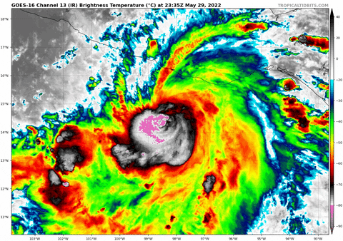
Agatha's satellite presentation has remained fairly steady state
since last evening. The center is embedded beneath a compact
central dense overcast, but there have been no microwave satellite
passes overnight to provide a better view of the hurricane's
structure. Dvorak estimates from TAFB and SAB are also steady,
remaining at T5.0, so Agatha's initial intensity is being held at
what the Air Force Reserve Hurricane Hunter found yesterday--95 kt.
A second and final Hurricane Hunter mission is scheduled for later
this morning, assuming the center isn't too close to the coast and
the plane can navigate a safe distance away from the nearby
mountainous terrain.

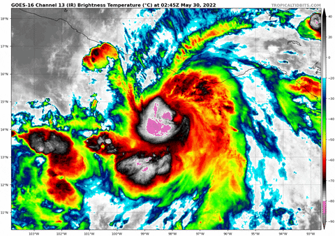
We did receive two ASCAT passes a few hours ago, which indicated
that tropical-storm-force winds have begun along the coast of
Oaxaca. The scatterometers also helped to refine Agatha's position,
and the initial motion remains slowly northeastward, or 055/5 kt.
This northeastward motion is expected to continue today, and
Agatha's center should cross the coast of Oaxaca within the next
12-18 hours. The center, or Agatha's remnants, should then continue
northeastward over the Isthmus of Tehuantepec. There have been no
notable shifts in the latest track guidance, thus the new NHC
forecast is very similar to the previous one.

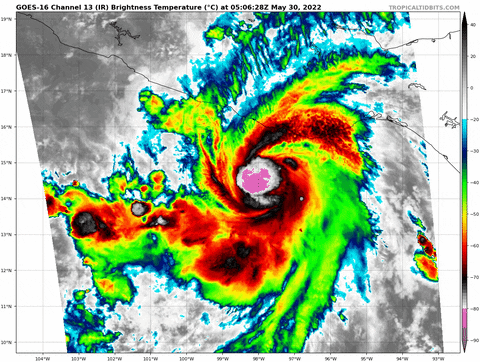
Agatha has another 12 hours or so to take advantage of warm 29
degree Celsius waters. However, the hurricane doesn't seem to have
been able to benefit from the waters during the previous 12 hours,
and it's not entirely clear if it will strengthen before landfall.
One potential negative influence is the nearby coastal mountains of
southern Mexico, which are likely to disrupt the low-level
circulation of the relatively small hurricane. Nearly all of the
intensity models show Agatha weakening immediately, but the NHC
forecast will maintain a steady intensity up until landfall, with
rapid weakening occurring once Agatha makes landfall and moves over
the rough terrain. This forecast does not preclude the possibility
of some intensification before landfall. Dissipation of Agatha's
surface circulation over southern Mexico is now expected by 48
hours.


Key Messages:

1. Extremely dangerous coastal flooding from storm surge,
accompanied by large and destructive waves, is expected near and the
east of where Agatha makes landfall.

2. Life-threatening hurricane-force winds are expected in portions
of the hurricane warning area in Oaxaca, Mexico, starting midday
and continuing through this evening. Tropical storm conditions
have already begun along the coast of Oaxaca and will spread
eastward within the warning area through today and tonight.

3. Heavy rains associated with Agatha will continue over portions of
southern Mexico through Tuesday. This will pose a threat of
potentially life-threatening flash flooding and mudslides.


FORECAST POSITIONS AND MAX WINDS

INIT 30/0900Z 14.8N 97.7W 95 KT 110 MPH
12H 30/1800Z 15.4N 96.8W 95 KT 110 MPH
24H 31/0600Z 16.3N 95.6W 60 KT 70 MPH...INLAND
36H 31/1800Z 16.9N 94.7W 35 KT 40 MPH...INLAND
48H 01/0600Z...DISSIPATED

$$
Forecaster Berg
0 likes   
Visit the Caribbean-Central America Weather Thread where you can find at first post web cams,radars
and observations from Caribbean basin members Click Here

User avatar
Yellow Evan
Professional-Met
Professional-Met
Posts: 15951
Age: 25
Joined: Fri Jul 15, 2011 12:48 pm
Location: Henderson, Nevada/Honolulu, HI
Contact:

Re: EPAC: AGATHA - Hurricane

#336 Postby Yellow Evan » Mon May 30, 2022 6:09 am

This is clearly tilted and badly sheared due to the displacement of the ULAC. Shear is divergent hence the cold cloud tops but with this little time left, it’s not going to be able to re-organize itself.
0 likes   

User avatar
cycloneye
Admin
Admin
Posts: 139052
Age: 67
Joined: Thu Oct 10, 2002 10:54 am
Location: San Juan, Puerto Rico

Re: EPAC: AGATHA - Hurricane

#337 Postby cycloneye » Mon May 30, 2022 7:14 am

BULLETIN
Hurricane Agatha Intermediate Advisory Number 10A
NWS National Hurricane Center Miami FL EP012022
700 AM CDT Mon May 30 2022

...AGATHA EXPECTED TO MAKE LANDFALL IN SOUTHERN MEXICO LATER
TODAY...
...STRONG WINDS AND HEAVY RAIN WILL CONTINUE TO INCREASE THROUGH THE
DAY...


SUMMARY OF 700 AM CDT...1200 UTC...INFORMATION
----------------------------------------------
LOCATION...15.1N 97.3W
ABOUT 65 MI...110 KM SW OF PUERTO ANGEL MEXICO
MAXIMUM SUSTAINED WINDS...110 MPH...175 KM/H
PRESENT MOVEMENT...NE OR 55 DEGREES AT 6 MPH...9 KM/H
MINIMUM CENTRAL PRESSURE...964 MB...28.47 INCHES
0 likes   
Visit the Caribbean-Central America Weather Thread where you can find at first post web cams,radars
and observations from Caribbean basin members Click Here

User avatar
kevin
Category 5
Category 5
Posts: 1767
Age: 25
Joined: Wed Aug 28, 2019 4:35 am

Re: EPAC: AGATHA - Hurricane

#338 Postby kevin » Mon May 30, 2022 8:03 am

First visual of Agatha this morning:

0 likes   

User avatar
skyline385
Category 5
Category 5
Posts: 2444
Age: 33
Joined: Wed Aug 26, 2020 11:15 pm
Location: Palm Beach County FL

Re: EPAC: AGATHA - Hurricane

#339 Postby skyline385 » Mon May 30, 2022 9:31 am

Probably going to see a downgrade once recon confirms
0 likes   

User avatar
kevin
Category 5
Category 5
Posts: 1767
Age: 25
Joined: Wed Aug 28, 2019 4:35 am

Re: EPAC: AGATHA - Hurricane

#340 Postby kevin » Mon May 30, 2022 9:33 am

ADT estimates are at 978mb/75kt. Recon has just descended to operational altitude so we'll find out whether those numbers verify soon enough.
1 likes   


Return to “2022”

Who is online

Users browsing this forum: No registered users and 30 guests