EPAC: CELIA - Post-Tropical

Moderator: S2k Moderators

Message
Author
User avatar
weeniepatrol
Category 3
Category 3
Posts: 847
Joined: Sat Aug 22, 2020 5:30 pm
Location: WA State

Re: EPAC: CELIA - Tropical Storm

#181 Postby weeniepatrol » Sun Jun 26, 2022 2:01 am

Kingarabian wrote:
weeniepatrol wrote:
Kingarabian wrote:Agreed.


Did have an impressive structure, that of a strong TS or minimal hurricane. Splitting hairs either way. I wonder if we this could be the first year since 2003 with no majors. We know how it goes though. Any old mjo pulse would likely generate a burst consisting of at least one


Good odds we'll see a major hurricane this season. Maybe later on in the season. That being said, the Atlantic is looking extremely ominous and La Nina forcing is beginning to reintensify.


Peep the subsurface... looks like an oncoming Nino lol. Unfortunately the trades are about to RIP
1 likes   

User avatar
Kingarabian
S2K Supporter
S2K Supporter
Posts: 15424
Joined: Sat Aug 08, 2009 3:06 am
Location: Honolulu, Hawaii

Re: EPAC: CELIA - Tropical Storm

#182 Postby Kingarabian » Sun Jun 26, 2022 2:05 am

weeniepatrol wrote:
Kingarabian wrote:
weeniepatrol wrote:
Did have an impressive structure, that of a strong TS or minimal hurricane. Splitting hairs either way. I wonder if we this could be the first year since 2003 with no majors. We know how it goes though. Any old mjo pulse would likely generate a burst consisting of at least one


Good odds we'll see a major hurricane this season. Maybe later on in the season. That being said, the Atlantic is looking extremely ominous and La Nina forcing is beginning to reintensify.


Peep the subsurface... looks like an oncoming Nino lol. Unfortunately the trades are about to RIP

Remember how much warm anomalies made it to the EPAC during February and March and it was all for nothing... Trades don't play.
3 likes   
RIP Kobe Bryant

User avatar
weeniepatrol
Category 3
Category 3
Posts: 847
Joined: Sat Aug 22, 2020 5:30 pm
Location: WA State

Re: EPAC: CELIA - Tropical Storm

#183 Postby weeniepatrol » Sun Jun 26, 2022 2:16 am

Kingarabian wrote:
weeniepatrol wrote:
Kingarabian wrote:
Good odds we'll see a major hurricane this season. Maybe later on in the season. That being said, the Atlantic is looking extremely ominous and La Nina forcing is beginning to reintensify.


Peep the subsurface... looks like an oncoming Nino lol. Unfortunately the trades are about to RIP

Remember how much warm anomalies made it to the EPAC during February and March and it was all for nothing... Trades don't play.


It's been one of the stranger progressions for sure. Just so the mods don't bonk me for straying off topic :D :


I think there is a good chance at reclassification to 65 kt in postanalysis. We will see
3 likes   

User avatar
cycloneye
Admin
Admin
Posts: 138789
Age: 67
Joined: Thu Oct 10, 2002 10:54 am
Location: San Juan, Puerto Rico

Re: EPAC: CELIA - Tropical Storm

#184 Postby cycloneye » Sun Jun 26, 2022 4:46 am

Tropical Storm Celia Discussion Number 39
NWS National Hurricane Center Miami FL EP032022
300 AM MDT Sun Jun 26 2022

Geostationary satellite imagery shows increased convection
on the western and southern sides of Celia's circulation.
However, as the system passed just south of the island of Socorro
yesterday, a weather station did not even measure any sustained
tropical-force-winds. Subjective and objective satellite intensity
estimates range between 40 and 55 kt. The initial intensity has
been lowered to 45 kt to reflect a compromise between all of the
estimates and observations. Celia will move into increasingly
unfavorable environmental conditions, with sea surface temperatures
below 25 C and a dry and stable airmass. Therefore, continued
weakening is expected. The official forecast predicts the system
will be post-tropical by 36 h and a remnant low in two days. This
intensity forecast is lower than most of the model guidance.

Celia is moving west-northwest at about 9 kt, steered by a mid-level
ridge. As the system loses convection and becomes a shallow remnant
low, it is expected to turn westward within the low-level trade
winds. The NHC track forecast lies on the southern half of the
guidance envelope partially due to the intensity forecast, assuming
a quicker westward turn for a weaker cyclone.


FORECAST POSITIONS AND MAX WINDS

INIT 26/0900Z 19.3N 113.1W 45 KT 50 MPH
12H 26/1800Z 19.7N 114.4W 40 KT 45 MPH
24H 27/0600Z 20.2N 116.1W 40 KT 45 MPH
36H 27/1800Z 21.0N 118.1W 35 KT 40 MPH...POST-TROPICAL
48H 28/0600Z 21.7N 120.2W 30 KT 35 MPH...POST-TROP/REMNT LOW
60H 28/1800Z 22.4N 122.2W 25 KT 30 MPH...POST-TROP/REMNT LOW
72H 29/0600Z 23.1N 124.4W 20 KT 25 MPH...POST-TROP/REMNT LOW
96H 30/0600Z...DISSIPATED

$$
Forecaster Bucci/Blake
0 likes   
Visit the Caribbean-Central America Weather Thread where you can find at first post web cams,radars
and observations from Caribbean basin members Click Here

Sciencerocks
Category 5
Category 5
Posts: 7266
Age: 38
Joined: Thu Jul 06, 2017 1:51 am

Re: EPAC: CELIA - Tropical Storm

#185 Postby Sciencerocks » Sun Jun 26, 2022 10:47 am

Image
1 likes   

User avatar
cycloneye
Admin
Admin
Posts: 138789
Age: 67
Joined: Thu Oct 10, 2002 10:54 am
Location: San Juan, Puerto Rico

Re: EPAC: CELIA - Tropical Storm

#186 Postby cycloneye » Sun Jun 26, 2022 1:01 pm

Tropical Storm Celia Discussion Number 40
NWS National Hurricane Center Miami FL EP032022
900 AM MDT Sun Jun 26 2022

This morning's satellite presentation shows very little change in
Celia's cloud pattern. However, the cloud tops associated with the
deep convection are beginning to warm. The latest AMSR2 microwave
revealed a symmetric cyclone with an eye-like feature in the
low-frequency band. Therefore, the initial intensity is
conservatively held at 45 kt and is supported by a blend of the
subjective and objective satellite intensity estimates.

Celia should gradually weaken while it moves into a stable and
dry surrounding atmosphere, and over cooler oceanic surface
temperatures. Accordingly, Celia is expected to degenerate into a
post-tropical cyclone on Monday and dissipate toward the end of the
week, and this scenario is in agreement with the latest statistical
and dynamical intensity guidance.

Celia's initial motion is estimated to be west-northwestward, or
285/6 kt, just a little bit to the left of the previous advisory
motion. The forecast track philosophy remains the same. A
mid-tropospheric ridge anchored over the eastern North Pacific
should steer the cyclone on a continued west-northwestward course
through the forecast period. The official NHC forecast is based on
the various tightly clustered consensus aids.


FORECAST POSITIONS AND MAX WINDS

INIT 26/1500Z 19.1N 113.7W 45 KT 50 MPH
12H 27/0000Z 19.5N 114.8W 40 KT 45 MPH
24H 27/1200Z 20.3N 116.7W 40 KT 45 MPH
36H 28/0000Z 21.1N 118.7W 35 KT 40 MPH...POST-TROPICAL
48H 28/1200Z 21.9N 120.8W 30 KT 35 MPH...POST-TROP/REMNT LOW
60H 29/0000Z 22.6N 123.0W 25 KT 30 MPH...POST-TROP/REMNT LOW
72H 29/1200Z 23.2N 125.0W 20 KT 25 MPH...POST-TROP/REMNT LOW
96H 30/1200Z...DISSIPATED

$$
Forecaster Roberts
0 likes   
Visit the Caribbean-Central America Weather Thread where you can find at first post web cams,radars
and observations from Caribbean basin members Click Here

User avatar
Yellow Evan
Professional-Met
Professional-Met
Posts: 15948
Age: 25
Joined: Fri Jul 15, 2011 12:48 pm
Location: Henderson, Nevada/Honolulu, HI
Contact:

Re: EPAC: CELIA - Tropical Storm

#187 Postby Yellow Evan » Sun Jun 26, 2022 1:53 pm

Yellow Evan wrote:Socorro Island observations have left a lot to be desired wind wise but the pressure is likely around 987 mbar or so. I'm very conflicted on how strong Celia really is.


Likely around 991-992 mbar. Forgot to take into account height of the observation station.
0 likes   

Sciencerocks
Category 5
Category 5
Posts: 7266
Age: 38
Joined: Thu Jul 06, 2017 1:51 am

Re: EPAC: CELIA - Tropical Storm

#188 Postby Sciencerocks » Sun Jun 26, 2022 3:08 pm

Image
0 likes   

User avatar
cycloneye
Admin
Admin
Posts: 138789
Age: 67
Joined: Thu Oct 10, 2002 10:54 am
Location: San Juan, Puerto Rico

Re: EPAC: CELIA - Tropical Storm

#189 Postby cycloneye » Sun Jun 26, 2022 3:36 pm

Tropical Storm Celia Discussion Number 41
NWS National Hurricane Center Miami FL EP032022
300 PM MDT Sun Jun 26 2022

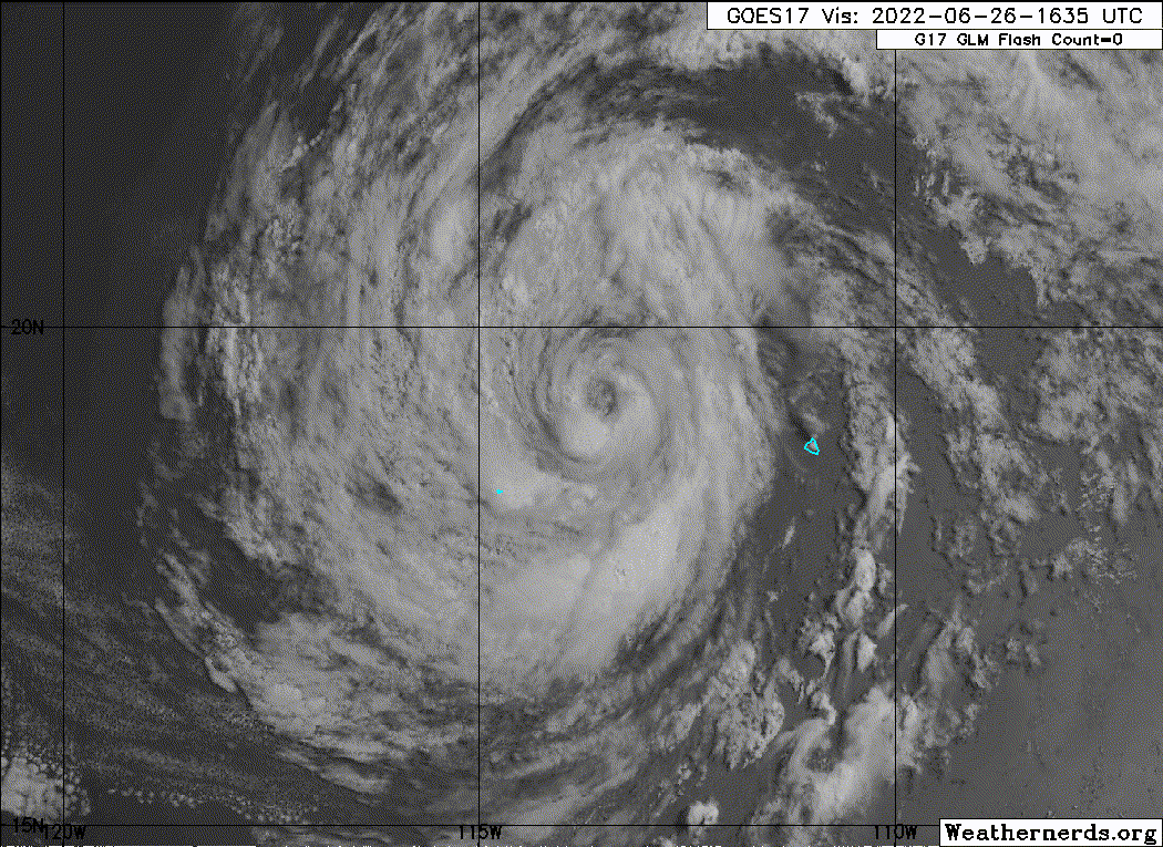
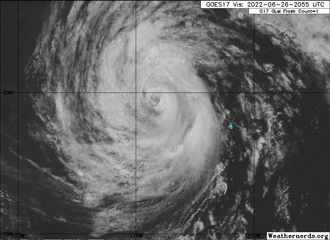
The storm continues to exhibit a well-organized cloud pattern on
satellite imagery, with a low-level eye-like feature and well
defined spiral cloud lines. However, the associated convection is
not very deep and most of the heavier showers and thunderstorms are
confined to the southeastern portion of the circulation. A
scatterometer pass missed most of the system but did show that
tropical-storm-force winds extended out about 90 n mi over the
eastern semicircle. The intensity is held at 45 kt for this
advisory, in accord with the latest Dvorak estimates from TAFB and
SAB.

Celia has continued to move west-northwestward, or 290/6 kt, but is
just slightly north of the previous track. A mid-level high
pressure ridge to the north of the tropical cyclone should maintain
this direction of motion, with a little acceleration, for the next
few days. The official track forecast follows the corrected
dynamical model consensus, HCCA, very closely.

The cyclone is crossing the gradient of SST and moving over
progressively cooler waters. This, along with a drier and more
stable air mass should cause Celia to degenerate into a remnant low
pressure system within a couple of days. The official intensity
forecast is at or above the model consensus.


FORECAST POSITIONS AND MAX WINDS

INIT 26/2100Z 19.5N 114.0W 45 KT 50 MPH
12H 27/0600Z 20.1N 115.5W 40 KT 45 MPH
24H 27/1800Z 20.9N 117.4W 35 KT 40 MPH
36H 28/0600Z 21.7N 119.4W 30 KT 35 MPH...POST-TROP/REMNT LOW
48H 28/1800Z 22.6N 121.4W 30 KT 35 MPH...POST-TROP/REMNT LOW
60H 29/0600Z 23.2N 123.5W 25 KT 30 MPH...POST-TROP/REMNT LOW
72H 29/1800Z 23.7N 125.4W 20 KT 25 MPH...POST-TROP/REMNT LOW
96H 30/1800Z...DISSIPATED

$$
Forecaster Pasch
0 likes   
Visit the Caribbean-Central America Weather Thread where you can find at first post web cams,radars
and observations from Caribbean basin members Click Here

User avatar
Yellow Evan
Professional-Met
Professional-Met
Posts: 15948
Age: 25
Joined: Fri Jul 15, 2011 12:48 pm
Location: Henderson, Nevada/Honolulu, HI
Contact:

Re: EPAC: CELIA - Tropical Storm

#190 Postby Yellow Evan » Sun Jun 26, 2022 6:08 pm

Image

Probably the best it’s ever looked in likely part due to excellent ULAC alignment. Could get a T4.5 with eye pattern.
5 likes   

User avatar
Yellow Evan
Professional-Met
Professional-Met
Posts: 15948
Age: 25
Joined: Fri Jul 15, 2011 12:48 pm
Location: Henderson, Nevada/Honolulu, HI
Contact:

Re: EPAC: CELIA - Tropical Storm

#191 Postby Yellow Evan » Sun Jun 26, 2022 6:36 pm

Image
3 likes   

User avatar
Kingarabian
S2K Supporter
S2K Supporter
Posts: 15424
Joined: Sat Aug 08, 2009 3:06 am
Location: Honolulu, Hawaii

Re: EPAC: CELIA - Tropical Storm

#192 Postby Kingarabian » Sun Jun 26, 2022 6:44 pm

:uarrow: That's a hurricane. I don't think the NHC will do it though. Too drastic of a change. If they re-up it, mMaybe 60kts max.
2 likes   
RIP Kobe Bryant

User avatar
Kingarabian
S2K Supporter
S2K Supporter
Posts: 15424
Joined: Sat Aug 08, 2009 3:06 am
Location: Honolulu, Hawaii

Re: EPAC: CELIA - Tropical Storm

#193 Postby Kingarabian » Sun Jun 26, 2022 7:02 pm

Image
0 likes   
RIP Kobe Bryant

Sciencerocks
Category 5
Category 5
Posts: 7266
Age: 38
Joined: Thu Jul 06, 2017 1:51 am

Re: EPAC: CELIA - Tropical Storm

#194 Postby Sciencerocks » Sun Jun 26, 2022 7:23 pm

Image
0 likes   

Sciencerocks
Category 5
Category 5
Posts: 7266
Age: 38
Joined: Thu Jul 06, 2017 1:51 am

Re: EPAC: CELIA - Tropical Storm

#195 Postby Sciencerocks » Sun Jun 26, 2022 7:24 pm

Certainly a hurricane!
3 likes   

User avatar
Yellow Evan
Professional-Met
Professional-Met
Posts: 15948
Age: 25
Joined: Fri Jul 15, 2011 12:48 pm
Location: Henderson, Nevada/Honolulu, HI
Contact:

Re: EPAC: CELIA - Tropical Storm

#196 Postby Yellow Evan » Sun Jun 26, 2022 7:33 pm

TXPZ23 KNES 270017
TCSENP

A. 03E (CELIA)

B. 26/2330Z

C. 19.8N

D. 114.6W

E. ONE/GOES-W

F. T3.5/3.5

G. IR/EIR/VIS

H. REMARKS...OW EYE SURROUNDED BY LG AND EMBEDDED IN MG RESULTS IN A DT
OF 4.0 WITH NO EADJ. SYSTEM HAS UNDERGONE SOLID INTENSIFICATION LAST 6
HR. 2306Z SSMIS PASS SHOWED AN EYE WITH A CLOSED RING OF CONVECTION. 6
HR AVERAGING OF DT <4.0 SO THIS DOES NOT JUSTIFY BREAKING CONSTRAINTS
AT THIS TIME. MET AND PT=4.0. FT IS BASED CONSTRAINTS DUE TO LIMIT OF
1.0 T-NUMBER CHANGE IN 6 HR.

I. ADDL POSITIONS

NIL


...KONON
0 likes   

User avatar
Kingarabian
S2K Supporter
S2K Supporter
Posts: 15424
Joined: Sat Aug 08, 2009 3:06 am
Location: Honolulu, Hawaii

Re: EPAC: CELIA - Tropical Storm

#197 Postby Kingarabian » Sun Jun 26, 2022 7:33 pm

I woulda broke constraints there...
0 likes   
RIP Kobe Bryant

User avatar
aspen
Category 5
Category 5
Posts: 8029
Joined: Sat Oct 12, 2019 7:10 pm
Location: Connecticut, USA

Re: EPAC: CELIA - Tropical Storm

#198 Postby aspen » Sun Jun 26, 2022 7:39 pm

This is Cristina ‘20 all over again lol
0 likes   
Irene '11 Sandy '12 Hermine '16 5/15/2018 Derecho Fay '20 Isaias '20 Elsa '21 Henri '21 Ida '21

I am only a meteorology enthusiast who knows a decent amount about tropical cyclones. Look to the professional mets, the NHC, or your local weather office for the best information.

User avatar
Kingarabian
S2K Supporter
S2K Supporter
Posts: 15424
Joined: Sat Aug 08, 2009 3:06 am
Location: Honolulu, Hawaii

Re: EPAC: CELIA - Tropical Storm

#199 Postby Kingarabian » Sun Jun 26, 2022 7:50 pm

Hopefully TAFB comes in clutch. Because ADT has a bad fix.
0 likes   
RIP Kobe Bryant

User avatar
Yellow Evan
Professional-Met
Professional-Met
Posts: 15948
Age: 25
Joined: Fri Jul 15, 2011 12:48 pm
Location: Henderson, Nevada/Honolulu, HI
Contact:

Re: EPAC: CELIA - Tropical Storm

#200 Postby Yellow Evan » Sun Jun 26, 2022 7:50 pm

Image
0 likes   


Return to “2022”

Who is online

Users browsing this forum: No registered users and 7 guests