EPAC: CELIA - Post-Tropical

Moderator: S2k Moderators

Message
Author
User avatar
cycloneye
Admin
Admin
Posts: 139082
Age: 67
Joined: Thu Oct 10, 2002 10:54 am
Location: San Juan, Puerto Rico

Re: EPAC: INVEST 93E

#21 Postby cycloneye » Thu Jun 16, 2022 2:40 pm

A. TROPICAL DISTURBANCE (93E)

B. 16/1730Z

C. 10.7N

D. 89.7W

E. THREE/GOES-E

F. T1.0/1.0

G. IR/EIR/VIS

H. REMARKS...LESS THAN 2/10 BANDING RESULTS IN DT OF 1.0. MET AND PT
AGREE. FT IS BASED ON DT.

I. ADDL POSITIONS

NIL


...BROWN
1 likes   
Visit the Caribbean-Central America Weather Thread where you can find at first post web cams,radars
and observations from Caribbean basin members Click Here

User avatar
cycloneye
Admin
Admin
Posts: 139082
Age: 67
Joined: Thu Oct 10, 2002 10:54 am
Location: San Juan, Puerto Rico

Re: EPAC: INVEST 93E

#22 Postby cycloneye » Thu Jun 16, 2022 3:16 pm

EP, 03, 2022061618, 01, CARQ, 0, 107N, 899W, 30, 1006, TD
2 likes   
Visit the Caribbean-Central America Weather Thread where you can find at first post web cams,radars
and observations from Caribbean basin members Click Here

NXStumpy_Robothing
Category 1
Category 1
Posts: 325
Age: 23
Joined: Fri Jun 05, 2020 11:50 pm
Location: North Georgia

Re: EPAC: INVEST 93E

#23 Postby NXStumpy_Robothing » Thu Jun 16, 2022 3:23 pm

cycloneye wrote:
EP, 03, 2022061618, 01, CARQ, 0, 107N, 899W, 30, 1006, TD

The convective pattern of this system is still somewhat lackluster in terms of intensity, coverage over the center, and structure, but it has been improving throughout the day. With the recent ASCAT pass showing winds of 25-30kt and a closed circulation, pulling the trigger on this was a no-brainer.

Very interested to see what the NHC does in regards to the forecast for both track and intensity, considering the shifts in model trends over the past 48 hours with the soon-to-be-christened TD 03E. It may even be necessary for some TS Watches and/or Warnings to be hoisted for portions of Central America.
0 likes   
Undergraduate Meteorology Student, Georgia Institute of Technology

User avatar
cycloneye
Admin
Admin
Posts: 139082
Age: 67
Joined: Thu Oct 10, 2002 10:54 am
Location: San Juan, Puerto Rico

Re: EPAC: Three-E - Tropical Depression

#24 Postby cycloneye » Thu Jun 16, 2022 3:53 pm

BULLETIN
Tropical Depression Three-E Advisory Number 1
NWS National Hurricane Center Miami FL EP032022
400 PM CDT Thu Jun 16 2022

...NEW TROPICAL DEPRESSION FORMS IN THE EAST PACIFIC...


SUMMARY OF 400 PM CDT...2100 UTC...INFORMATION
----------------------------------------------
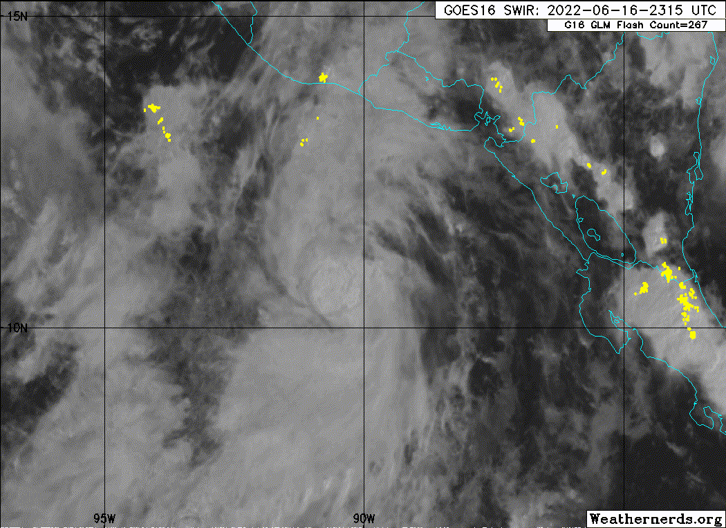
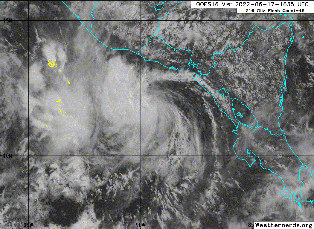
LOCATION...10.8N 89.9W
ABOUT 205 MI...330 KM SSW OF SAN SALVADOR EL SALVADOR
ABOUT 220 MI...360 KM SSE OF PUERTO SAN JOSE GUATEMALA
MAXIMUM SUSTAINED WINDS...35 MPH...55 KM/H
PRESENT MOVEMENT...N OR 360 DEGREES AT 2 MPH...4 KM/H
MINIMUM CENTRAL PRESSURE...1006 MB...29.71 INCHES


Tropical Depression Three-E Discussion Number 1
NWS National Hurricane Center Miami FL EP032022
400 PM CDT Thu Jun 16 2022

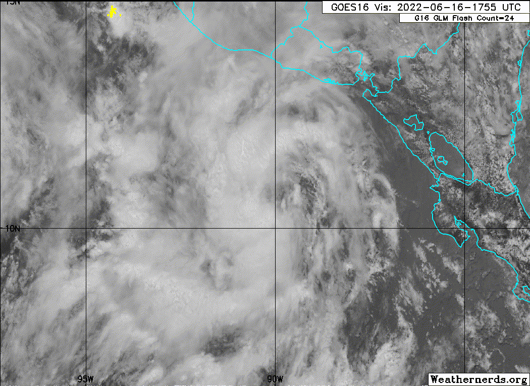
Over the past 12 h, there has been a notable improvement on
satellite of the convective structure with an area of low pressure
NHC has been monitoring to the south of the coasts of El Salvador
and Guatemala. An earlier scatterometer pass showed that the system
had developed a well-defined center, with maximum winds between
25-30 kt. These winds also matched a nearby ship observation in the
northern semicircle of the system. Subsequent visible satellite
imagery depicted convection gradually increasing near the
circulation center, especially in a curved band on its western
side. This improving structure is also seen well on a recently
arriving AMSR2 microwave pass. For these reasons, the system now
meets the criteria of a tropical cyclone, and the initial intensity
will be set to 30 kt for this advisory.

Three-E has been making a slow cyclonic loop over the past 24 hours,
and now appears to be drifting northward, estimated at 355/2 kt. The
track guidance in the short-term is rather tricky, as the steering
currents near the system appear to be light and variable, with the
largest steering influence expected to be monsoonal flow around a
larger-scale circulation over Central America involving another
disturbance over the northwestern Caribbean Sea. The track guidance
is rather spread out over the first couple of days with the ECMWF on
the left side and GFS on right side of the track guidance envelope.
After 36 hours, a mid-level ridge is expected to gradually build in
to the north of the cyclone, resulting in a gradual bend westward
and some increase in forward motion. The initial track forecast
currently lies near the center of the track suite, close to the HFIP
Corrected Consensus Approach (HCCA).

Environmental conditions appear generally favorable for some
intensification over the next day or so, with shear under 10 kt,
high mid-level moisture, and sea-surface temperatures above 27 C.
However, easterly shear is expected to increase after 36 hours, and
the slow motion of the system may leave it susceptible to upwelling
cooler waters under a fairly shallow mixed layer depth of warm
waters in the far East Pacific. The initial intensity forecast only
shows a peak intensity of 45 kt in 36 hours and holds the system at
that intensity for the remainder of the period. This intensity
forecast roughly splits the difference between higher
statistical-dynamical guidance (SHIPS) versus lower dynamical and
consensus aids (HMON, IVCN). Given the uncertainty in the short-term
track of this depression, this intensity forecast is of relatively
low confidence.


FORECAST POSITIONS AND MAX WINDS

INIT 16/2100Z 10.8N 89.9W 30 KT 35 MPH
12H 17/0600Z 11.1N 89.9W 35 KT 40 MPH
24H 17/1800Z 11.5N 89.9W 40 KT 45 MPH
36H 18/0600Z 12.2N 89.9W 45 KT 50 MPH
48H 18/1800Z 12.8N 90.3W 45 KT 50 MPH
60H 19/0600Z 12.9N 91.0W 45 KT 50 MPH
72H 19/1800Z 12.9N 91.8W 45 KT 50 MPH
96H 20/1800Z 12.9N 94.5W 45 KT 50 MPH
120H 21/1800Z 12.8N 99.4W 45 KT 50 MPH

$$
Forecaster Papin


Image
0 likes   
Visit the Caribbean-Central America Weather Thread where you can find at first post web cams,radars
and observations from Caribbean basin members Click Here

Sciencerocks
Category 5
Category 5
Posts: 7286
Age: 38
Joined: Thu Jul 06, 2017 1:51 am

Re: EPAC: THREE-E - Tropical Depression

#25 Postby Sciencerocks » Thu Jun 16, 2022 4:17 pm

Image
0 likes   

User avatar
cycloneye
Admin
Admin
Posts: 139082
Age: 67
Joined: Thu Oct 10, 2002 10:54 am
Location: San Juan, Puerto Rico

Re: EPAC: THREE-E - Tropical Depression

#26 Postby cycloneye » Thu Jun 16, 2022 7:52 pm

A. 03E (NONAME)

B. 16/2330Z

C. 11.1N

D. 90.1W

E. FIVE/GOES-E

F. T1.5/1.5

G. IR/EIR/VIS

H. REMARKS...0.25 CURVED BANDING RESULTS IN A DT OF 1.0. THE MET IS
1.0. THE PT IS 1.5. THE FT IS BASED ON THE PT DUE TO THE RECENCY WITH
WHICH THE CONVECTION COMPRISING THE MEASURED BAND DEVELOPED.

I. ADDL POSITIONS

NIL


...HOSLEY
0 likes   
Visit the Caribbean-Central America Weather Thread where you can find at first post web cams,radars
and observations from Caribbean basin members Click Here

User avatar
Kingarabian
S2K Supporter
S2K Supporter
Posts: 15434
Joined: Sat Aug 08, 2009 3:06 am
Location: Honolulu, Hawaii

Re: EPAC: THREE-E - Tropical Depression

#27 Postby Kingarabian » Thu Jun 16, 2022 7:58 pm

A bit tilted:
Image

Will probably struggle till it gets further west.
0 likes   
RIP Kobe Bryant

User avatar
cycloneye
Admin
Admin
Posts: 139082
Age: 67
Joined: Thu Oct 10, 2002 10:54 am
Location: San Juan, Puerto Rico

Re: EPAC: THREE-E - Tropical Depression

#28 Postby cycloneye » Thu Jun 16, 2022 9:42 pm

Tropical Depression Three-E Discussion Number 2
NWS National Hurricane Center Miami FL EP032022
1000 PM CDT Thu Jun 16 2022

There has not been much change in the organization of the
depression over the past several hours. The system is
producing a small area of very deep convection mainly over the
southern portion of the circulation, but banding features are not
very well-defined at this time. Subjective Dvorak intensity
estimates from TAFB and SAB are still below tropical storm strength
so the cyclone's intensity is maintained at 30 kt for this advisory.

Center fixes from satellite images suggest only a very slow
movement and the current motion estimate is about 350/2 kt. The
system is in an environment of weak steering currents, as it
remains under the influence of a low-level cyclonic gyre over
Central America. This scenario should continue to prevail for the
next day or so, so a slow motion is forecast through 36 hours.
Thereafter, a mid-tropospheric ridge is forecast by the global
models to build to the north of the tropical cyclone, which should
induce a more westward motion in 2-5 days. The track guidance has
shifted somewhat to the left compared to the previous advisory
package, and the official forecast is shifted a little southwest of
the previous NHC prediction. The simple and corrected consensus
tracks are even farther to the left, so some additional adjustments
may be needed in subsequent forecasts.

The cyclone is in a generally conducive atmospheric environment
with high humidity and fairly low shear. However the presence of
a shallow oceanic mixed layer over the far eastern Pacific could
cause the slow-moving system to be influenced by the upwelling of
cooler waters. Therefore only modest strengthening is anticipated
during the next day or so, as in the previous NHC forecast. The
dynamical guidance indicates an increase in easterly shear in a
couple of days, which is expected to limit strengthening. The
official intensity forecast is near or a little above the simple
and corrected consensus predictions, IVCN and HCCA respectively.

FORECAST POSITIONS AND MAX WINDS

INIT 17/0300Z 11.1N 90.1W 30 KT 35 MPH
12H 17/1200Z 11.3N 90.0W 35 KT 40 MPH
24H 18/0000Z 11.8N 90.1W 40 KT 45 MPH
36H 18/1200Z 12.4N 90.5W 45 KT 50 MPH
48H 19/0000Z 12.7N 91.2W 45 KT 50 MPH
60H 19/1200Z 12.7N 92.0W 45 KT 50 MPH
72H 20/0000Z 12.5N 93.3W 45 KT 50 MPH
96H 21/0000Z 12.4N 96.5W 50 KT 60 MPH
120H 22/0000Z 13.0N 101.2W 55 KT 65 MPH

$$
Forecaster Pasch
0 likes   
Visit the Caribbean-Central America Weather Thread where you can find at first post web cams,radars
and observations from Caribbean basin members Click Here

Sciencerocks
Category 5
Category 5
Posts: 7286
Age: 38
Joined: Thu Jul 06, 2017 1:51 am

Re: EPAC: THREE-E - Tropical Depression

#29 Postby Sciencerocks » Thu Jun 16, 2022 9:46 pm

Image
1 likes   

User avatar
skyline385
Category 5
Category 5
Posts: 2444
Age: 33
Joined: Wed Aug 26, 2020 11:15 pm
Location: Palm Beach County FL

Re: EPAC: THREE-E - Tropical Depression

#30 Postby skyline385 » Thu Jun 16, 2022 11:45 pm

GFS may have gone a bit nuts on 03E, lets see how the Hurricane models fare

Image
0 likes   

Sciencerocks
Category 5
Category 5
Posts: 7286
Age: 38
Joined: Thu Jul 06, 2017 1:51 am

Re: EPAC: THREE-E - Tropical Depression

#31 Postby Sciencerocks » Fri Jun 17, 2022 2:39 am

Image
1 likes   

User avatar
cycloneye
Admin
Admin
Posts: 139082
Age: 67
Joined: Thu Oct 10, 2002 10:54 am
Location: San Juan, Puerto Rico

Re: EPAC: THREE-E - Tropical Depression

#32 Postby cycloneye » Fri Jun 17, 2022 3:43 am

Tropical Depression Three-E Discussion Number 3
NWS National Hurricane Center Miami FL EP032022
400 AM CDT Fri Jun 17 2022

Satellite imagery indicates that there has not been much change in
the organization of Tropical Depression Three-E since the last
advisory, with the system maintaining a small cluster of convection
near and south of the center. However, scatterometer data and a
GMI microwave overpass showed that the center was a bit to the east
of the previous advisory position. Subjective and objective
satellite intensity estimates are in the 30-40 kt range, while the
scatterometer data showed winds of 25-30 kt. Based on this, the
initial intensity is held at a possibly conservative 30 kt.

The initial motion is a somewhat uncertain 360/4. The depression is
currently in an area of weak steering currents associated with a
large low-level cyclonic gyre over Central America. This should
allow a slow northward motion to continue for the next 12-24 h.
After that, a building mid- to upper-level ridge north of the
cyclone should cause a turn toward the west, with a general
westward motion continuing through the forecast period. The new
forecast track has some adjustments from the previous track in the
first 24-36 h based on the more easterly initial position. By the
end of the forecast period, though, it is similar to the previous
track. The new track is north of the consensus models from 36-72
h, and this part of the forecast may need some southward adjustment
in subsequent advisories.

Conditions appear favorable for the cyclone to strengthen during
the next 12-24 h, and the intensity forecast calls for it to become
a tropical storm during this time. After that, the global models
are in good agreement that moderate to strong easterly shear is
going to develop over the system. The intensity guidance shows
some spread, with some models showing little or no strengthening
from 24-120 h while others forecast gradual strengthening. Since
the cyclone will be moving over increasing sea surface temperatures
in a moist environment with strong upper-level divergence, the
intensity forecast calls for some gradual strengthening in spite of
the shear from 24-120 h.

Interests along the coasts of El Salvador, Honduras, and
southeastern Mexico should monitor the progress of this system.
While the cyclone is expected to stay offshore, any motion to the
north of the current forecast track, or a system that gets larger
than forecast, would require a tropical storm watch or warning for
part of this area. Heavy rains are likely over portions of Central
America regardless of how close the forecast tropical-storm force
winds get to the coast.


FORECAST POSITIONS AND MAX WINDS

INIT 17/0900Z 11.3N 89.6W 30 KT 35 MPH
12H 17/1800Z 11.8N 89.5W 35 KT 40 MPH
24H 18/0600Z 12.2N 89.8W 40 KT 45 MPH
36H 18/1800Z 12.4N 90.2W 40 KT 45 MPH
48H 19/0600Z 12.5N 91.0W 45 KT 50 MPH
60H 19/1800Z 12.4N 92.1W 45 KT 50 MPH
72H 20/0600Z 12.2N 93.6W 45 KT 50 MPH
96H 21/0600Z 12.5N 97.0W 50 KT 60 MPH
120H 22/0600Z 13.5N 101.5W 55 KT 65 MPH

$$
Forecaster Beven
0 likes   
Visit the Caribbean-Central America Weather Thread where you can find at first post web cams,radars
and observations from Caribbean basin members Click Here

User avatar
Extratropical94
Professional-Met
Professional-Met
Posts: 3535
Age: 29
Joined: Wed Oct 20, 2010 6:36 am
Location: Hamburg, Germany
Contact:

Re: EPAC: THREE-E - Tropical Depression

#33 Postby Extratropical94 » Fri Jun 17, 2022 8:14 am

EP, 03, 2022061712, , BEST, 0, 115N, 894W, 35, 1004, TS


Smells like Celia out there.
3 likes   
54° 11' 59'' N, 9° 9' 20'' E
Boomer Sooner!
Go Broncos! Go Cards! Go Niners!
- Daniel

User avatar
InfernoFlameCat
Category 5
Category 5
Posts: 1966
Age: 21
Joined: Mon Dec 14, 2020 10:52 am
Location: Buford, GA

Re: EPAC: THREE-E - Tropical Depression

#34 Postby InfernoFlameCat » Fri Jun 17, 2022 8:32 am

Celia could be a biggen
0 likes   
I am by no means a professional. DO NOT look at my forecasts for official information or make decisions based on what I post.

Goal: to become a registered expert over tropical and subtropical cyclones.

zzh
Category 1
Category 1
Posts: 375
Joined: Fri Aug 27, 2021 2:18 pm

Re: EPAC: THREE-E - Tropical Depression

#35 Postby zzh » Fri Jun 17, 2022 9:50 am

NHC issuing advisories for the Eastern Pacific on Hurricane Blas and TS Celia
1 likes   

User avatar
KirbyDude25
Tropical Storm
Tropical Storm
Posts: 117
Age: 19
Joined: Mon Sep 20, 2021 8:03 am

Re: EPAC: CELIA - Tropical Storm

#36 Postby KirbyDude25 » Fri Jun 17, 2022 10:00 am

Tropical Storm Celia Discussion Number 4
NWS National Hurricane Center Miami FL EP032022
1000 AM CDT Fri Jun 17 2022

The satellite presentation of the system has improved somewhat this
morning, with a well-defined band in its western semicircle and
some deep convection persisting near and just west of the
estimated center. Subjective intensity estimates are up to 35 kt
from SAB and 45 kt from TAFB, while the most recent objective
intensity estimates from UW-CIMSS were in the 40-45 kt range. There
were also a few wind retrievals from overnight scatterometer
imagery in the 34-36 kt range. The initial intensity has been set to
a possibly conservative 35 kt for this advisory, upgrading Tropical
Depression Three-E to Tropical Storm Celia.

Celia still appears to be drifting generally northward, with the
initial motion estimated at 020/4 kt. As discussed in the prior
advisory, the storm is currently embedded within weak steering
currents as a result of being a small vortex embedded within a much
broader low-level cyclonic circulation centered over Central
America, causing Celia to drift just east of due north over the past
12-18 hours. Possibly due to this small size, the model guidance
does not have a good handle on the current position or structure of
the cyclone. For example, the latest GFS run places Celia about 150
nm west of its actual position. The latest ECMWF run was closer to
the correct position but barely depicts Celia as a distinct entity
within the larger gyre circulation. Even the higher-resolution
regional hurricane models are struggling to depict this cyclone.
Given these difficulties, the short-term track forecast is quite
problematic, with the track guidance spread more than double the
typical climatological value in the 24-48 hour period. Generally the
guidance has shifted further south this cycle, when Celia is
expected to be steered by a building mid-level ridge and perhaps
some low-level flow enhanced by a gap wind event in the Gulf of
Tehuantepec. The track forecast this advisory follows suit, and is
further south than the previous advisory after 36 hours, but still
is not as far south as the reliable consensus aids. Given all the
complicating factors above, this track forecast is of low
confidence.

The substantial uncertainty in the track forecast also applies to
the current intensity forecast with Celia. Easterly vertical wind
shear is already starting to increase over the system, as suggested
by both GFS- and ECMWF- based SHIPS guidance, and is forecast to be
above 20 kt in 24-36 hours. The GFS model, which seems to be best
capturing Celia's current structure, quickly shears off the current
deep convection to the east due to the increasing upper-level flow.
In addition, current sea-surface temperatures (SSTs) under the
cyclone are already marginal (26-27 C) and could cool further over
the next 36 hours given Celia's slow motion. The intensity guidance
this cycle is lower than the previous one for the first 48-72 hours,
and only some slight additional intensification is anticipated
before these negative factors limit Celia's intensity. Towards the
end of the forecast period, the shear is expected to decrease and
SSTs warm, which could provide an opportunity for the storm to began
intensifying again. However, it is also possible the negative
factors indicated above may result in Celia weakening or
degenerating into a remnant low, devoid of organized convection, as
suggested by the ECMWF solution.

Key Messages:

1. Areas of heavy rainfall are expected north of Celia's track
across portions of far southern Mexico, Guatemala and El Salvador
through Sunday. This rainfall may cause some instances of flash
flooding and mudslides across the region.

2. Interests along the coasts of El Salvador, Honduras, and
southeastern Mexico should monitor the progress of this system.
While Celia is expected to stay offshore, any motion to the north of
the current forecast track, or increase in size could require a
tropical storm watch or warning for part of this area.


FORECAST POSITIONS AND MAX WINDS

INIT 17/1500Z 11.6N 89.3W 35 KT 40 MPH
12H 18/0000Z 11.8N 89.3W 40 KT 45 MPH
24H 18/1200Z 12.1N 89.5W 40 KT 45 MPH
36H 19/0000Z 12.2N 90.0W 40 KT 45 MPH
48H 19/1200Z 12.2N 90.8W 40 KT 45 MPH
60H 20/0000Z 11.9N 92.4W 40 KT 45 MPH
72H 20/1200Z 11.7N 94.2W 40 KT 45 MPH
96H 21/1200Z 12.2N 98.4W 40 KT 45 MPH
120H 22/1200Z 13.0N 102.5W 50 KT 60 MPH

$$
Forecaster Papin
0 likes   
New Jersey, Rutgers '27
Irene 2011 | Sandy 2012 | Fay 2020 | Isaias 2020 | Ida 2021

Sciencerocks
Category 5
Category 5
Posts: 7286
Age: 38
Joined: Thu Jul 06, 2017 1:51 am

Re: EPAC: CELIA - Tropical Storm

#37 Postby Sciencerocks » Fri Jun 17, 2022 10:20 am

Image
1 likes   

User avatar
Iceresistance
Category 5
Category 5
Posts: 8913
Age: 20
Joined: Sat Oct 10, 2020 9:45 am
Location: Tecumseh, OK/Norman, OK

Re: EPAC: CELIA - Tropical Storm

#38 Postby Iceresistance » Fri Jun 17, 2022 10:35 am

I did not expect this to form because of the shear from Blas.
0 likes   
Bill 2015 & Beta 2020

Winter 2020-2021 :cold:

All observations are in Tecumseh, OK unless otherwise noted.

Winter posts are focused mainly for Oklahoma & Texas.

Take any of my forecasts with a grain of salt, refer to the NWS, SPC, and NHC for official information

Never say Never with weather! Because ANYTHING is possible!

Sciencerocks
Category 5
Category 5
Posts: 7286
Age: 38
Joined: Thu Jul 06, 2017 1:51 am

Re: EPAC: CELIA - Tropical Storm

#39 Postby Sciencerocks » Fri Jun 17, 2022 3:02 pm

Image
0 likes   

User avatar
cycloneye
Admin
Admin
Posts: 139082
Age: 67
Joined: Thu Oct 10, 2002 10:54 am
Location: San Juan, Puerto Rico

Re: EPAC: CELIA - Tropical Storm

#40 Postby cycloneye » Fri Jun 17, 2022 3:47 pm

Tropical Storm Celia Discussion Number 5
NWS National Hurricane Center Miami FL EP032022
400 PM CDT Fri Jun 17 2022

Overall the satellite presentation of Celia is a bit less
impressive this afternoon, with the deepest convective cloud tops
starting to become increasingly displaced from the low-level
circulation center, which is now partially exposed to the east
of the convection. Subjective Dvorak intensity estimates for 1800
UTC were unchanged from SAB (T2.5/35 kt) and TAFB (T4.0/45 kt) from
this morning, though objective estimates from the UW-CIMSS Advanced
Dvorak Technique (ADT) and SATCON have decreased some this
afternoon. Unfortunately this afternoon's scatterometer swaths
missed Celia's small wind field. The initial intensity will
remain 35 kt for this advisory.

The northward drift with Celia continues, with the latest motion
estimated at 360/3 kt. As mentioned over the past day, Celia
remains under light and variable steering flow on the south side of
a broader monsoonal circulation parked over Central America. This
broad low-level circulation should gradually break down as a
pronounced mid-level ridge centered over the southern US amplifies
and extends westward over Mexico. This changing synoptic pattern
should result in Celia turning westward or even west-southwestward
as it also gradually accelerates over the next 2-3 days. While there
remains larger-than-average spread in the track guidance this
afternoon, especially in the across-track direction, this general
evolution is favored. The latest NHC track forecast is just a touch
further south and faster compared to the previous advisory, and now
lies pretty near the HCCA consensus aid.

Celia's intensity may have already peaked earlier this morning, as
easterly vertical wind shear now appears to be displacing the
convection further west which is decreasing in overall intensity as
cloud tops warm. SHIPS guidance suggests the current shear will only
increase further over the next 24 hours, and Celia is no longer
expected to intensify further in the short-term. Assuming the
tropical cyclone survives the relatively hostile environment
forecast over the next several days, shear is expected to decrease
towards the end of the forecast period as it moves towards warmer
ocean waters (28-29 C). Therefore, intensification could resume by
early next week. The latest intensity forecast is a bit lower than
this morning, but still remains above most of the guidance over the
next 48 hours. Thereafter, some gradual intensification is shown,
roughly splitting the difference between the HCCA and IVCN
consensus.

Key Messages:

1. Areas of heavy rainfall are expected north of Celia's track
across portions of far southern Mexico, Guatemala and El Salvador
through Sunday. This rainfall may cause some instances of flash
flooding and mudslides across the region.

2. Interests along the coasts of El Salvador, Honduras, and
southeastern Mexico should monitor the progress of this system.
While Celia is expected to stay offshore, any motion to the north of
the current forecast track, or increase in size could require a
tropical storm watch or warning for part of this area.


FORECAST POSITIONS AND MAX WINDS

INIT 17/2100Z 11.8N 89.4W 35 KT 40 MPH
12H 18/0600Z 12.1N 89.4W 35 KT 40 MPH
24H 18/1800Z 12.3N 89.8W 35 KT 40 MPH
36H 19/0600Z 12.2N 90.7W 35 KT 40 MPH
48H 19/1800Z 11.8N 92.1W 35 KT 40 MPH
60H 20/0600Z 11.5N 93.8W 35 KT 40 MPH
72H 20/1800Z 11.6N 95.8W 40 KT 45 MPH
96H 21/1800Z 12.5N 100.4W 45 KT 50 MPH
120H 22/1800Z 13.7N 104.3W 55 KT 65 MPH

$$
Forecaster Papin
0 likes   
Visit the Caribbean-Central America Weather Thread where you can find at first post web cams,radars
and observations from Caribbean basin members Click Here


Return to “2022”

Who is online

Users browsing this forum: No registered users and 76 guests