

EPAC: BONNIE - Post-Tropical - Discussion
Moderator: S2k Moderators
-
ScottNAtlanta

- Category 5

- Posts: 1998
- Joined: Sat May 25, 2013 3:11 pm
- Location: Atlanta, GA
Re: EPAC: BONNIE - Hurricane - Discussion
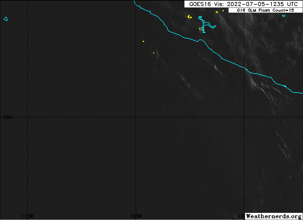
cheezyWXguy wrote:Given its progression through the ERC, I’m skeptical recon would actually find cat3 winds at this time, considering what double eye walls can do to flatten the pressure gradient. It’s understandable though since Dvorak is really all we have to go off of right now. Either way, if shear holds off long enough to let the new eye clear out there won’t be any more question that it’s a major
It looks like an ERC is well underway as the small pinhole eye seems to have collapsed. NHC brought it to a major at the 10am adv (central time)
0 likes
The posts in this forum are NOT official forecast and should not be used as such. They are just the opinion of the poster and may or may not be backed by sound meteorological data. They are NOT endorsed by any professional institution or storm2k.org. For official information, please refer to the NHC and NWS products.
-
Yellow Evan

- Professional-Met

- Posts: 15951
- Age: 25
- Joined: Fri Jul 15, 2011 12:48 pm
- Location: Henderson, Nevada/Honolulu, HI
- Contact:
Re: EPAC: BONNIE - Hurricane - Discussion
ERC likely finished itself overnight as evident by the strengthening trend then.
0 likes
-
cheezyWXguy

- Category 5
- Posts: 5528
- Joined: Mon Feb 13, 2006 12:29 am
- Location: Dallas, TX
Re: EPAC: BONNIE - Hurricane - Discussion
Yellow Evan wrote:ERC likely finished itself overnight as evident by the strengthening trend then.
Could be but I’m not convinced. Still seeing hot towers firing on the inner wall, and an apparent moat on vis
0 likes
-
Sciencerocks
- Category 5
- Posts: 7282
- Age: 38
- Joined: Thu Jul 06, 2017 1:51 am
-
DEMI-TITAN6
- S2K Supporter

- Posts: 12
- Age: 60
- Joined: Fri Feb 12, 2021 3:04 pm
- Location: Tamarac, Florida
Re: EPAC: BONNIE - Hurricane - Discussion
Rules of the game...
Bonnie turns into a major hurricane, Guess it won't count in the Storm2k 2022 Atlantic Hurricane Season prediction but just a tropical storm...
Major Hurricane Bonnie, The Storm That Got Away!
Bonnie turns into a major hurricane, Guess it won't count in the Storm2k 2022 Atlantic Hurricane Season prediction but just a tropical storm...
Major Hurricane Bonnie, The Storm That Got Away!
0 likes
Storm tracker since 1977 (47 years)
Formally King6 , KingBubbaCat6.
Formally King6 , KingBubbaCat6.

Re: EPAC: BONNIE - Hurricane - Discussion
Yellow Evan wrote:ERC likely finished itself overnight as evident by the strengthening trend then.
The EWRC is still ongoing. Either it finished last night but another one started, or this is the same EWRC that has been going on for the last 18 hours. Whatever the case, Bonnie is has been taking quite a while to finally get its core sorted out, which raises the possibility of its cycle being interrupted by shear or dry air.
0 likes
Irene '11 Sandy '12 Hermine '16 5/15/2018 Derecho Fay '20 Isaias '20 Elsa '21 Henri '21 Ida '21
I am only a meteorology enthusiast who knows a decent amount about tropical cyclones. Look to the professional mets, the NHC, or your local weather office for the best information.
I am only a meteorology enthusiast who knows a decent amount about tropical cyclones. Look to the professional mets, the NHC, or your local weather office for the best information.
-
Hurricane Mike
- Category 2

- Posts: 562
- Joined: Tue Apr 10, 2018 7:44 am
Re: EPAC: BONNIE - Hurricane - Discussion
New video on Hurricane Bonnie
https://www.youtube.com/watch?v=l19KtxDYCS8
https://www.youtube.com/watch?v=l19KtxDYCS8
0 likes
-
Yellow Evan
- Professional-Met
- Posts: 15951
- Age: 25
- Joined: Fri Jul 15, 2011 12:48 pm
- Location: Henderson, Nevada/Honolulu, HI
- Contact:
Re: EPAC: BONNIE - Hurricane - Discussion
TXPZ25 KNES 051807
TCSENP
A. 02L (BONNIE)
B. 05/1730Z
C. 15.4N
D. 105.2W
E. ONE/GOES-E
F. T5.5/6.0
G. IR/EIR/VIS
H. REMARKS...LG EYE SURROUNDED BY W AND EMB IN B RESULTS IN DT OF
5.5 WITH NO EYE ADJ. MET IS 5.0 DUE TO SLOW DEVELOPMENT OVER PREV 24
HOURS. PT IS 5.5. FT IS BASED ON DT.
I. ADDL POSITIONS
NIL
...BROWN
TCSENP
A. 02L (BONNIE)
B. 05/1730Z
C. 15.4N
D. 105.2W
E. ONE/GOES-E
F. T5.5/6.0
G. IR/EIR/VIS
H. REMARKS...LG EYE SURROUNDED BY W AND EMB IN B RESULTS IN DT OF
5.5 WITH NO EYE ADJ. MET IS 5.0 DUE TO SLOW DEVELOPMENT OVER PREV 24
HOURS. PT IS 5.5. FT IS BASED ON DT.
I. ADDL POSITIONS
NIL
...BROWN
0 likes
-
cheezyWXguy
- Category 5
- Posts: 5528
- Joined: Mon Feb 13, 2006 12:29 am
- Location: Dallas, TX
-
Hypercane_Kyle

- Category 5
- Posts: 2899
- Joined: Sat Mar 07, 2015 7:58 pm
- Location: Cape Canaveral, FL
Re: EPAC: BONNIE - Hurricane - Discussion
Definitely about to drop a nice, big eye. Could make a run for Cat 4 if it keeps its structure up.
0 likes
My posts are my own personal opinion, defer to the National Hurricane Center (NHC) and other NOAA products for decision making during hurricane season.
-
Sciencerocks
- Category 5
- Posts: 7282
- Age: 38
- Joined: Thu Jul 06, 2017 1:51 am

-
Yellow Evan
- Professional-Met
- Posts: 15951
- Age: 25
- Joined: Fri Jul 15, 2011 12:48 pm
- Location: Henderson, Nevada/Honolulu, HI
- Contact:
Re: EPAC: BONNIE - Hurricane - Discussion
Shear will probably prevent further intensification today but starting tomorrow and into Thursday, door is open even if SSTs are marginal.
0 likes
-
skyline385

- Category 5
- Posts: 2444
- Age: 33
- Joined: Wed Aug 26, 2020 11:15 pm
- Location: Palm Beach County FL
Re: EPAC: BONNIE - Hurricane - Discussion
That recon looks like it's heading for Bonnie, was there one scheduled today?
Sent from my LM-V405 using Tapatalk
Sent from my LM-V405 using Tapatalk
0 likes
Re: EPAC: BONNIE - Hurricane - Discussion
skyline385 wrote:That recon looks like it's heading for Bonnie, was there one scheduled today?
Sent from my LM-V405 using Tapatalk
It’s not longer heading to Bonnie, it’s just bouncing around the Gulf. I don’t know what it’s doing and I didn’t see anything about recon for Bonnie in the EPac.
0 likes
Irene '11 Sandy '12 Hermine '16 5/15/2018 Derecho Fay '20 Isaias '20 Elsa '21 Henri '21 Ida '21
I am only a meteorology enthusiast who knows a decent amount about tropical cyclones. Look to the professional mets, the NHC, or your local weather office for the best information.
I am only a meteorology enthusiast who knows a decent amount about tropical cyclones. Look to the professional mets, the NHC, or your local weather office for the best information.
-
cycloneye

- Admin

- Posts: 139027
- Age: 67
- Joined: Thu Oct 10, 2002 10:54 am
- Location: San Juan, Puerto Rico
Re: EPAC: BONNIE - Hurricane - Discussion
skyline385 wrote:That recon looks like it's heading for Bonnie, was there one scheduled today?
Sent from my LM-V405 using Tapatalk
Nothing at TCPOD. That is a training mission in northern GOM.
2 likes
Visit the Caribbean-Central America Weather Thread where you can find at first post web cams,radars
and observations from Caribbean basin members Click Here
and observations from Caribbean basin members Click Here
-
Yellow Evan
- Professional-Met
- Posts: 15951
- Age: 25
- Joined: Fri Jul 15, 2011 12:48 pm
- Location: Henderson, Nevada/Honolulu, HI
- Contact:
Re: EPAC: BONNIE - Hurricane - Discussion
* GFS version *
* EAST PACIFIC 2021 SHIPS INTENSITY FORECAST *
* IR SAT DATA AVAILABLE, OHC AVAILABLE *
* BONNIE EP042022 07/06/22 00 UTC *
TIME (HR) 0 6 12 18 24 36 48 60 72 84 96 108 120 132 144 156 168
V (KT) NO LAND 95 91 88 88 87 82 78 69 64 56 48 43 37 33 29 29 28
V (KT) LAND 95 91 88 88 87 82 78 69 64 56 48 43 37 33 29 29 28
V (KT) LGEM 95 92 89 86 84 77 70 61 52 44 37 32 29 26 23 N/A N/A
Storm Type TROP TROP TROP TROP TROP TROP TROP TROP TROP TROP TROP TROP TROP TROP TROP N/A N/A
SHEAR (KT) 15 15 13 7 5 3 5 5 4 8 10 13 15 14 13 N/A N/A
SHEAR ADJ (KT) 2 2 -1 -1 -1 6 6 6 4 -1 -4 -5 -7 -3 0 N/A N/A
SHEAR DIR 5 15 12 7 5 11 155 246 247 212 224 225 234 237 219 N/A N/A
SST (C) 28.8 28.8 28.5 28.1 27.7 27.0 26.2 25.2 24.3 22.7 23.0 22.5 22.4 22.4 23.4 N/A N/A
POT. INT. (KT) 154 153 150 145 141 135 127 117 108 91 94 89 88 87 98 N/A N/A
200 MB T (C) -52.4 -52.5 -52.5 -52.2 -52.0 -52.2 -51.9 -52.2 -52.0 -52.4 -52.6 -52.6 -52.6 -52.7 -53.4 N/A N/A
200 MB VXT (C) 0.4 0.6 0.6 0.6 0.6 0.9 0.9 1.1 0.7 0.7 1.0 1.1 1.0 0.7 0.6 N/A N/A
TH_E DEV (C) 7 6 5 5 4 3 3 2 1 1 1 1 2 2 2 N/A N/A
700-500 MB RH 66 65 64 62 61 58 52 49 43 41 38 35 29 29 29 N/A N/A
MODEL VTX (KT) 17 16 17 19 20 20 19 16 15 13 12 10 8 7 5 LOST LOST
850 MB ENV VOR 29 21 18 31 38 54 51 30 33 29 25 9 -5 -15 -18 N/A N/A
200 MB DIV 7 53 51 30 3 -6 4 -25 10 -5 -2 -22 -13 -53 -17 N/A N/A
700-850 TADV -6 -6 -3 -1 1 1 1 4 1 0 2 2 1 6 6 N/A N/A
LAND (KM) 443 485 553 626 704 726 852 986 1213 1413 1659 1934 2006 1693 1380 N/A N/A
LAT (DEG N) 15.6 15.9 16.1 16.3 16.4 17.1 17.6 18.3 19.2 19.8 20.1 20.3 20.5 xx.x xx.x N/A N/A
LONG(DEG W) 106.5 107.7 108.9 109.9 110.9 113.2 115.9 118.8 122.4 125.8 129.0 132.2 135.6 xxx.x xxx.x N/A N/A
STM SPEED (KT) 12 12 11 10 11 12 14 16 17 16 15 15 15 14 14 N/A N/A
HEAT CONTENT 13 13 11 7 6 4 0 0 0 0 0 0 0 0 0 N/A N/A
FORECAST TRACK FROM OFCI INITIAL HEADING/SPEED (DEG/KT):285/ 13 CX,CY: -12/ 3
T-12 MAX WIND: 100 PRESSURE OF STEERING LEVEL (MB): 499 (MEAN=587)
GOES IR BRIGHTNESS TEMP. STD DEV. 50-200 KM RAD: 12.3 (MEAN=14.5)
% GOES IR PIXELS WITH T < -20 C 50-200 KM RAD: 84.0 (MEAN=65.0)
PRELIM RI PROB (DV .GE. 35 KT IN 36 HR): 1.0
INDIVIDUAL CONTRIBUTIONS TO INTENSITY CHANGE
6 12 18 24 36 48 60 72 84 96 108 120 132 144 156 168
------------------------------------------------------------------------------
SAMPLE MEAN CHANGE 0. 0. 1. 1. 1. 2. 1. 1. 0. -0. -1. -2. -2. -3. -4. -4.
SST POTENTIAL 0. 1. 1. 0. -4. -10. -17. -24. -31. -36. -41. -45. -50. -54. -56. -60.
VERTICAL SHEAR MAG -2. -4. -4. -4. -2. 0. 3. 6. 7. 8. 8. 7. 5. 5. 6. 6.
VERTICAL SHEAR ADJ -0. -0. 0. 0. -0. -1. -2. -1. -1. -0. -0. -0. 0. 0. 0. 0.
VERTICAL SHEAR DIR 0. 0. 0. 0. 0. 0. -0. -1. -1. -2. -2. -2. -2. -2. -2. -1.
PERSISTENCE -1. -2. -2. -2. -2. -1. -0. 0. 0. 0. 0. 1. 1. 1. 0. 0.
200/250 MB TEMP. -0. -0. -0. -0. -1. -0. 0. 1. 2. 3. 4. 6. 7. 8. 9. 10.
THETA_E EXCESS -0. -0. -0. -1. -2. -3. -4. -5. -7. -8. -9. -9. -10. -10. -12. -13.
700-500 MB RH 0. 0. 0. 0. -0. -0. -0. -1. -1. -1. -1. -2. -2. -3. -4. -5.
MODEL VTX TENDENCY -1. -0. 1. 2. 2. 1. -2. -3. -6. -8. -9. -11. -12. -13. -11. -10.
850 MB ENV VORTICITY -0. -0. -0. 0. 0. -0. -0. -0. -0. -0. -0. 0. 0. 0. 0. 0.
200 MB DIVERGENCE -0. -0. -0. -0. -1. -1. -2. -3. -3. -4. -4. -3. -2. -1. 0. 2.
850-700 T ADVEC 0. 0. 0. 0. 0. -0. 0. 0. 0. 0. 0. 0. 0. 0. 1. 1.
ZONAL STORM MOTION 0. 0. 1. 1. 1. 2. 2. 2. 2. 1. 1. 1. 1. 1. 0. -0.
STEERING LEVEL PRES -0. -0. -0. -1. -1. -1. -1. -1. -1. -2. -2. -2. -1. -1. -1. -0.
DAYS FROM CLIM. PEAK -0. -0. -0. -0. -0. -0. -0. -1. -1. -2. -2. -2. -2. -3. -3. -4.
GOES PREDICTORS -0. -1. -1. -2. -1. 0. 0. 1. 1. 1. 1. 1. 1. 2. 2. 3.
OCEAN HEAT CONTENT -0. -0. -0. -0. -0. -1. -1. -1. -0. -0. 0. 1. 2. 2. 4. 5.
RI POTENTIAL -0. -1. -2. -2. -4. -4. -3. -1. 1. 2. 3. 4. 4. 4. 4. 4.
------------------------------------------------------------------------------
TOTAL CHANGE -4. -7. -7. -8. -13. -17. -26. -31. -39. -47. -52. -58. -62. -66. -66. -67.
CURRENT MAX WIND (KT): 95. LAT, LON: 15.6 106.5
** 2021 E. Pacific RI INDEX EP042022 BONNIE 07/06/22 00 UTC **
(SHIPS-RII PREDICTOR TABLE for 30 KT OR MORE MAXIMUM WIND INCREASE IN NEXT 24-h)
Predictor Value RI Predictor Range Scaled Value(0-1) % Contribution
POT = MPI-VMAX (KT) : 53.7 40.5 to 149.3 0.12 0.7
12 HR PERSISTENCE (KT) : -5.0 -22.0 to 44.0 0.26 1.6
D200 (10**7s-1) : 28.8 -33.0 to 159.5 0.32 1.7
850-200 MB SHEAR (KT) : 11.1 19.6 to 1.3 0.46 2.3
MAXIMUM WIND (KT) : 95.0 22.5 to 132.0 0.50 1.9
STD DEV OF IR BR TEMP : 12.3 37.8 to 2.1 0.71 2.5
BL DRY-AIR FLUX (W/M2) : 446.2 800.8 to -82.5 0.40 -1.6
HEAT CONTENT (KJ/CM2) : 10.0 2.7 to 106.7 0.07 0.2
%area of TPW <45 mm upshear : 0.0 56.6 to 0.0 1.00 1.1
2nd PC OF IR BR TEMP : -0.3 2.2 to -2.3 0.56 0.3
SHIPS Prob RI for 20kt/ 12hr RI threshold= 6% is 0.9 times climatological mean ( 6.3%)
SHIPS Prob RI for 25kt/ 24hr RI threshold= 16% is 1.0 times climatological mean (12.5%)
SHIPS Prob RI for 30kt/ 24hr RI threshold= 11% is 1.4 times climatological mean ( 8.6%)
SHIPS Prob RI for 35kt/ 24hr RI threshold= 9% is 1.8 times climatological mean ( 6.2%)
SHIPS Prob RI for 40kt/ 24hr RI threshold= 8% is 1.9 times climatological mean ( 4.2%)
SHIPS Prob RI for 45kt/ 36hr RI threshold= 0% is 0.0 times climatological mean ( 6.7%)
SHIPS Prob RI for 55kt/ 48hr RI threshold= 0% is 0.0 times climatological mean ( 5.9%)
SHIPS Prob RI for 65kt/ 72hr RI threshold= 0% is 0.0 times climatological mean ( 4.7%)
Matrix of RI probabilities
------------------------------------------------------------------------------
RI (kt / h) | 20/12 | 25/24 | 30/24 | 35/24 | 40/24 | 45/36 | 55/48 |65/72
------------------------------------------------------------------------------
SHIPS-RII: 5.9% 15.8% 10.7% 8.5% 7.9% 0.0% 0.0% 0.0%
Logistic: 0.5% 1.1% 0.5% 0.2% 0.2% 0.0% 0.0% 0.0%
Bayesian: 0.0% 0.0% 0.0% 0.0% 0.0% 0.0% 0.0% 0.0%
Consensus: 2.1% 5.6% 3.8% 2.9% 2.7% 0.0% 0.0% 0.0%
DTOPS: 1.0% 7.0% 3.0% 2.0% 2.0% 0.0% 0.0% 0.0%
## ANNULAR HURRICANE INDEX (AHI) EP042022 BONNIE 07/06/22 00 UTC ##
## STORM NOT ANNULAR, SCREENING STEP FAILED, NPASS=5 NFAIL=2 ##
## AHI= 0 (AHI OF 100 IS BEST FIT TO ANN. STRUC., 1 IS MARGINAL, 0 IS NOT ANNULAR) ##
Re-intensification window opens in about 12 hours and lasts for 36-48 hours.
0 likes
Re: EPAC: BONNIE - Hurricane - Discussion
I’m doubtful Bonnie will be able to recover from this EWRC. It is still going on after over 24 hours with no progress being made, and it’s looking more lopsided tonight. Shear will drop, but so will SSTs and RH. Bonnie might be in a damaged state where it ingests dry air and can’t take advantage of the lower shear.
0 likes
Irene '11 Sandy '12 Hermine '16 5/15/2018 Derecho Fay '20 Isaias '20 Elsa '21 Henri '21 Ida '21
I am only a meteorology enthusiast who knows a decent amount about tropical cyclones. Look to the professional mets, the NHC, or your local weather office for the best information.
I am only a meteorology enthusiast who knows a decent amount about tropical cyclones. Look to the professional mets, the NHC, or your local weather office for the best information.
-
cycloneye
- Admin
- Posts: 139027
- Age: 67
- Joined: Thu Oct 10, 2002 10:54 am
- Location: San Juan, Puerto Rico
Re: EPAC: BONNIE - Hurricane - Discussion
0 likes
Visit the Caribbean-Central America Weather Thread where you can find at first post web cams,radars
and observations from Caribbean basin members Click Here
and observations from Caribbean basin members Click Here
-
cycloneye
- Admin
- Posts: 139027
- Age: 67
- Joined: Thu Oct 10, 2002 10:54 am
- Location: San Juan, Puerto Rico
Re: EPAC: BONNIE - Hurricane - Discussion
Down from cat 3.
EP, 04, 2022070600, , BEST, 0, 156N, 1065W, 95, 968, HU
0 likes
Visit the Caribbean-Central America Weather Thread where you can find at first post web cams,radars
and observations from Caribbean basin members Click Here
and observations from Caribbean basin members Click Here
Who is online
Users browsing this forum: No registered users and 33 guests