EPAC: DARBY - Remnants
Moderator: S2k Moderators
-
Sciencerocks
- Category 5

- Posts: 7287
- Age: 38
- Joined: Thu Jul 06, 2017 1:51 am
-
cheezyWXguy

- Category 5
- Posts: 5536
- Joined: Mon Feb 13, 2006 12:29 am
- Location: Dallas, TX
Re: EPAC: DARBY - Hurricane
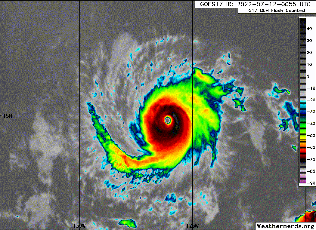
Wow the weakening is coming on fast now. Structure still looks pretty good but man are those cloud tops warming
0 likes
Re: EPAC: DARBY - Hurricane
St0rmTh0r wrote:This might be a dumb question but why don't the hurricane hunters fly into the storms from above the eye instead of blasting through the eyewall?
The aircraft cannot fly that high. The deep convection extends to 15 km altitude.
0 likes
Re: EPAC: DARBY - Hurricane
Category5Kaiju wrote:Is it just me, or do EPAC storms tend to have higher pressures than their Atlantic counterparts in many cases (especially low to mid-end Cat 4 storms?) I would think for a 140 mph hurricane, the minimum pressure would be expected to be in the 940s or so? For example, Douglas 2020 was 130/954, Genevieve 2020 was 130/950, Felicia 2021 was 145/945, and Linda 2021 was 130/953. Compare that to many Atlantic storms (like Harvey was 130/937, Danielle 2010 was 130/942, Ophelia 2011 was 140/940, Gonzalo 2014 was 145/940, and Sam was at one point 140/943?)
Compact storms like this one can support stronger winds for a given central pressure. It is the radial pressure gradient which matters.
0 likes
-
ElectricStorm

- Category 5
- Posts: 4566
- Age: 23
- Joined: Tue Aug 13, 2019 11:23 pm
- Location: Skiatook, OK / Norman, OK
Re: EPAC: DARBY - Hurricane
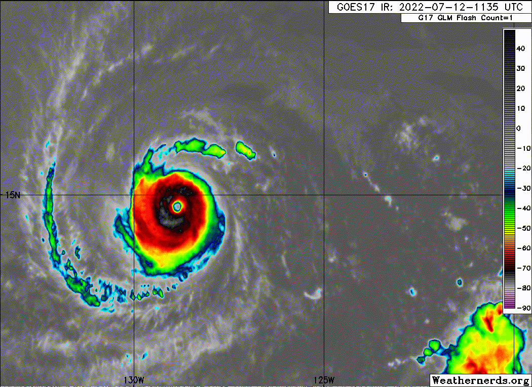
Cloud tops have cooled again. Still going strong
0 likes
I am in no way a professional. Take what I say with a grain of salt as I could be totally wrong. Please refer to the NHC, NWS, or SPC for official information.
Boomer Sooner!
Boomer Sooner!

Re: EPAC: DARBY - Hurricane
ElectricStorm wrote:Cloud tops have cooled again. Still going strong
Now the eye has started cooling, though. Darby is probably on its way out now.
0 likes
Irene '11 Sandy '12 Hermine '16 5/15/2018 Derecho Fay '20 Isaias '20 Elsa '21 Henri '21 Ida '21
I am only a meteorology enthusiast who knows a decent amount about tropical cyclones. Look to the professional mets, the NHC, or your local weather office for the best information.
I am only a meteorology enthusiast who knows a decent amount about tropical cyclones. Look to the professional mets, the NHC, or your local weather office for the best information.
-
Yellow Evan

- Professional-Met

- Posts: 15954
- Age: 25
- Joined: Fri Jul 15, 2011 12:48 pm
- Location: Henderson, Nevada/Honolulu, HI
- Contact:
Re: EPAC: DARBY - Hurricane
TXPZ26 KNES 121202
TCSENP
A. 05E (DARBY)
B. 12/1130Z
C. 14.7N
D. 128.8W
E. ONE/GOES-W
F. T5.5/6.0
G. IR/EIR/SWIR
H. REMARKS...SYSTEM CHARACTERIZED BY A OW EYE SURROUNDED BY B AND
EMBEDDED IN LG FOR A DT=5.5 AFTER ADDING 0.5 FOR AN EYE ADJUSTMENT. MET
AND PT AGREE. FT IS BASED ON DT.
I. ADDL POSITIONS
NIL
...FISHER
TCSENP
A. 05E (DARBY)
B. 12/1130Z
C. 14.7N
D. 128.8W
E. ONE/GOES-W
F. T5.5/6.0
G. IR/EIR/SWIR
H. REMARKS...SYSTEM CHARACTERIZED BY A OW EYE SURROUNDED BY B AND
EMBEDDED IN LG FOR A DT=5.5 AFTER ADDING 0.5 FOR AN EYE ADJUSTMENT. MET
AND PT AGREE. FT IS BASED ON DT.
I. ADDL POSITIONS
NIL
...FISHER
0 likes
-
cycloneye

- Admin

- Posts: 139127
- Age: 67
- Joined: Thu Oct 10, 2002 10:54 am
- Location: San Juan, Puerto Rico
Re: EPAC: DARBY - Hurricane
0 likes
Visit the Caribbean-Central America Weather Thread where you can find at first post web cams,radars
and observations from Caribbean basin members Click Here
and observations from Caribbean basin members Click Here
-
cycloneye
- Admin
- Posts: 139127
- Age: 67
- Joined: Thu Oct 10, 2002 10:54 am
- Location: San Juan, Puerto Rico
Re: EPAC: DARBY - Hurricane
Begins to go down on intensity.
EP, 05, 2022071212, , BEST, 0, 147N, 1290W, 115, 957, HU
0 likes
Visit the Caribbean-Central America Weather Thread where you can find at first post web cams,radars
and observations from Caribbean basin members Click Here
and observations from Caribbean basin members Click Here
-
cheezyWXguy
- Category 5
- Posts: 5536
- Joined: Mon Feb 13, 2006 12:29 am
- Location: Dallas, TX
Re: EPAC: DARBY - Hurricane
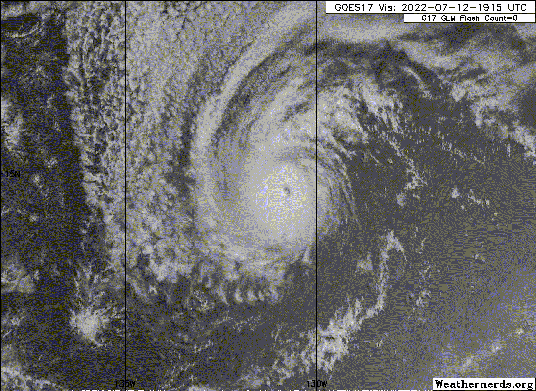
Darby really stepped up the annular presentation overnight, but if it can manage the cooling sst’s long enough to finish this ERC and carve out that larger eye, it’ll basically be a full-on donut
0 likes
-
Sciencerocks
- Category 5
- Posts: 7287
- Age: 38
- Joined: Thu Jul 06, 2017 1:51 am

Re: EPAC: DARBY - Hurricane


6 likes
Kendall -> SLO -> PBC
Memorable Storms: Katrina (for its Florida landfall...) Wilma Matthew Irma
Memorable Storms: Katrina (for its Florida landfall...) Wilma Matthew Irma
-
cheezyWXguy
- Category 5
- Posts: 5536
- Joined: Mon Feb 13, 2006 12:29 am
- Location: Dallas, TX

Re: EPAC: DARBY - Hurricane
Darby is making a jog southwest. That'll help with a burst of strengthening.
0 likes
The above post and any post by Ntxw is NOT an official forecast and should not be used as such. It is just the opinion of the poster and may or may not be backed by sound meteorological data. It is NOT endorsed by any professional institution including Storm2k. For official information, please refer to NWS products.
Help support Storm2K!

-
InfernoFlameCat

- Category 5
- Posts: 1966
- Age: 21
- Joined: Mon Dec 14, 2020 10:52 am
- Location: Buford, GA
Re: EPAC: DARBY - Hurricane
Darby is improving once again. The eye warmed up and the north easterly shear has calmed down a bit.
0 likes
I am by no means a professional. DO NOT look at my forecasts for official information or make decisions based on what I post.
Goal: to become a registered expert over tropical and subtropical cyclones.
Goal: to become a registered expert over tropical and subtropical cyclones.
-
Yellow Evan
- Professional-Met
- Posts: 15954
- Age: 25
- Joined: Fri Jul 15, 2011 12:48 pm
- Location: Henderson, Nevada/Honolulu, HI
- Contact:
Re: EPAC: DARBY - Hurricane
TXPZ26 KNES 121806
TCSENP
A. 05E (DARBY)
B. 12/1730Z
C. 14.6N
D. 130.3W
E. ONE/GOES-W
F. T4.5/5.5
G. IR/EIR/VIS
H. REMARKS...SYSTEM CHARACTERIZED BY AN OW EYE SURROUNDED BY LG AND
EMBEDDED IN MG FOR A DT=4.5 WITH NO EYE ADJUSTMENT. MET AND PT AGREE. FT
IS BASED ON DT.
I. ADDL POSITIONS
NIL
...FISHER
TCSENP
A. 05E (DARBY)
B. 12/1730Z
C. 14.6N
D. 130.3W
E. ONE/GOES-W
F. T4.5/5.5
G. IR/EIR/VIS
H. REMARKS...SYSTEM CHARACTERIZED BY AN OW EYE SURROUNDED BY LG AND
EMBEDDED IN MG FOR A DT=4.5 WITH NO EYE ADJUSTMENT. MET AND PT AGREE. FT
IS BASED ON DT.
I. ADDL POSITIONS
NIL
...FISHER
Terrible fix. Embedded in LG and eye is WMG.
1 likes
-
cycloneye
- Admin
- Posts: 139127
- Age: 67
- Joined: Thu Oct 10, 2002 10:54 am
- Location: San Juan, Puerto Rico
Re: EPAC: DARBY - Hurricane
EP, 05, 2022071218, , BEST, 0, 146N, 1305W, 105, 966, HU
0 likes
Visit the Caribbean-Central America Weather Thread where you can find at first post web cams,radars
and observations from Caribbean basin members Click Here
and observations from Caribbean basin members Click Here
-
NXStumpy_Robothing
- Category 1

- Posts: 325
- Age: 23
- Joined: Fri Jun 05, 2020 11:50 pm
- Location: North Georgia
Re: EPAC: DARBY - Hurricane
Yellow Evan wrote:TXPZ26 KNES 121806
TCSENP
A. 05E (DARBY)
-snip-
F. T4.5/5.5
-snip-
Terrible fix. Embedded in LG and eye is WMG.
How in the hell did they manage to pull off a T4.5 fix when the system has pretty consistently been fluctuating between T5.5 and T6.0 for the last twelve hours?
Completely agreed, bad fix. Have to be better especially with these smaller systems, since the Dvorak technique consistently underestimates and cannot properly recognize the structure of such storms. Thankfully NHC's recent discussions (especially from Papin) show that they're aware of this flaw. Here's hoping a more permanent resolution can be achieved in the near-future with Dvorak constraints/criteria.
1 likes
Undergraduate Meteorology Student, Georgia Institute of Technology
-
skyline385

- Category 5
- Posts: 2444
- Age: 33
- Joined: Wed Aug 26, 2020 11:15 pm
- Location: Palm Beach County FL
-
Sciencerocks
- Category 5
- Posts: 7287
- Age: 38
- Joined: Thu Jul 06, 2017 1:51 am
Who is online
Users browsing this forum: No registered users and 22 guests