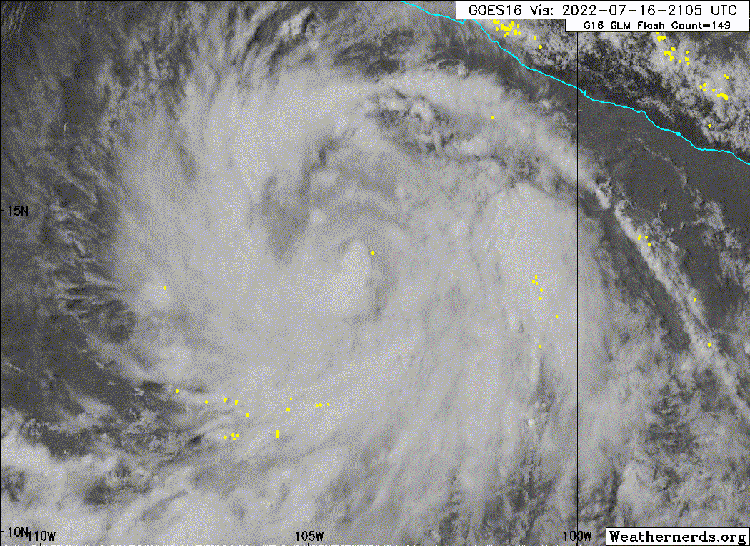
EPAC: ESTELLE - Post-Tropical

Moderator: S2k Moderators

Message
Author
User avatar
skyline385
Category 5
Category 5
Posts: 2444
Age: 33
Joined: Wed Aug 26, 2020 11:15 pm
Location: Palm Beach County FL

Re: EPAC: ESTELLE - Tropical Storm

#81 Postby skyline385 » Sat Jul 16, 2022 6:33 pm

InfernoFlameCat wrote:
aspen wrote:Estelle has a very large circulation and banding like what the HWRF has been showing for days. With this large circulation and core, Estelle will probably struggle to intensify much like on the model.

It has a tight inner core. I don’t see much getting in the way of this thing. A large envelope can occur with smaller hurricanes. Wilma is an example of this. It had a large circulation but a tiny core.

Yea, a trademark of most Cat 4/5 hurricanes is the outer banding becoming decoupled with the CDO and rotating relatively slowly while the center goes nuts.
1 likes   

User avatar
cycloneye
Admin
Admin
Posts: 139041
Age: 67
Joined: Thu Oct 10, 2002 10:54 am
Location: San Juan, Puerto Rico

Re: EPAC: ESTELLE - Tropical Storm

#82 Postby cycloneye » Sat Jul 16, 2022 7:13 pm

2 likes   
Visit the Caribbean-Central America Weather Thread where you can find at first post web cams,radars
and observations from Caribbean basin members Click Here

Sciencerocks
Category 5
Category 5
Posts: 7282
Age: 38
Joined: Thu Jul 06, 2017 1:51 am

Re: EPAC: ESTELLE - Tropical Storm

#83 Postby Sciencerocks » Sat Jul 16, 2022 7:31 pm

Image
5 likes   

User avatar
cycloneye
Admin
Admin
Posts: 139041
Age: 67
Joined: Thu Oct 10, 2002 10:54 am
Location: San Juan, Puerto Rico

Re: EPAC: ESTELLE - Tropical Storm

#84 Postby cycloneye » Sat Jul 16, 2022 7:33 pm

A. 06E (ESTELLE)

B. 16/2330Z

C. 14.5N

D. 104.4W

E. THREE/GOES-E

F. T3.5/3.5

G. IR/EIR/VIS

H. REMARKS...9/10 BANDING RESULTS IN A DT OF 3.5. MET AND PT ARE 4.0
BASED ON RAPID 24-HOUR DEVELOPMENT. FT IS BASED ON DT.

I. ADDL POSITIONS

NIL


...CLARK
0 likes   
Visit the Caribbean-Central America Weather Thread where you can find at first post web cams,radars
and observations from Caribbean basin members Click Here

User avatar
Yellow Evan
Professional-Met
Professional-Met
Posts: 15951
Age: 25
Joined: Fri Jul 15, 2011 12:48 pm
Location: Henderson, Nevada/Honolulu, HI
Contact:

Re: EPAC: ESTELLE - Tropical Storm

#85 Postby Yellow Evan » Sat Jul 16, 2022 7:40 pm

Image

If this wants to RI it better do so now. Shear is going to disrupt Estelle by 12z if the 18z GFS is correct.
0 likes   

User avatar
Kingarabian
S2K Supporter
S2K Supporter
Posts: 15434
Joined: Sat Aug 08, 2009 3:06 am
Location: Honolulu, Hawaii

Re: EPAC: ESTELLE - Tropical Storm

#86 Postby Kingarabian » Sat Jul 16, 2022 7:44 pm

Would classify this as a hurricane now. That big burst of convection near the center pushed it over the top. Yet to see a hint of an IR/VIS eye though.
0 likes   
RIP Kobe Bryant

User avatar
Yellow Evan
Professional-Met
Professional-Met
Posts: 15951
Age: 25
Joined: Fri Jul 15, 2011 12:48 pm
Location: Henderson, Nevada/Honolulu, HI
Contact:

Re: EPAC: ESTELLE - Tropical Storm

#87 Postby Yellow Evan » Sat Jul 16, 2022 7:47 pm

EP, 06, 202207170000, 10, DVTS, CI, , 1430N, 10440W, , 3, 65, 2, 987, 2, DVRK, , , , , , , , , , , , , , E, TAFB, AR, VI, 5, 4040 /////, , , GOES16, CSC, T, Estelle looking really impressive - did not do the C
0 likes   

User avatar
cycloneye
Admin
Admin
Posts: 139041
Age: 67
Joined: Thu Oct 10, 2002 10:54 am
Location: San Juan, Puerto Rico

Re: EPAC: ESTELLE - Tropical Storm

#88 Postby cycloneye » Sat Jul 16, 2022 7:48 pm

Hurricane.

EP, 06, 2022071700, , BEST, 0, 144N, 1045W, 65, 991, HU
1 likes   
Visit the Caribbean-Central America Weather Thread where you can find at first post web cams,radars
and observations from Caribbean basin members Click Here

User avatar
InfernoFlameCat
Category 5
Category 5
Posts: 1966
Age: 21
Joined: Mon Dec 14, 2020 10:52 am
Location: Buford, GA

Re: EPAC: ESTELLE - Tropical Storm

#89 Postby InfernoFlameCat » Sat Jul 16, 2022 9:01 pm

Eye is clearing out on ir. I thought this would happen. If it can keep it up, cat 5 might be obtainable.Hwrf might have had the right idea!
0 likes   
I am by no means a professional. DO NOT look at my forecasts for official information or make decisions based on what I post.

Goal: to become a registered expert over tropical and subtropical cyclones.

User avatar
ElectricStorm
Category 5
Category 5
Posts: 4525
Age: 23
Joined: Tue Aug 13, 2019 11:23 pm
Location: Skiatook, OK / Norman, OK

Re: EPAC: ESTELLE - Tropical Storm

#90 Postby ElectricStorm » Sat Jul 16, 2022 9:06 pm

InfernoFlameCat wrote:Eye is clearing out on ir. I thought this would happen. If it can keep it up, cat 5 might be obtainable.Hwrf might have had the right idea!

I'll be shocked if this becomes a Cat 5 but I think we could see a 3 or even a 4 out of this. It seems like the shear isn't much of a problem right now, but we'll see how long that lasts.
0 likes   
I am in no way a professional. Take what I say with a grain of salt as I could be totally wrong. Please refer to the NHC, NWS, or SPC for official information.

Boomer Sooner!

User avatar
InfernoFlameCat
Category 5
Category 5
Posts: 1966
Age: 21
Joined: Mon Dec 14, 2020 10:52 am
Location: Buford, GA

Re: EPAC: ESTELLE - Tropical Storm

#91 Postby InfernoFlameCat » Sat Jul 16, 2022 9:19 pm

ElectricStorm wrote:
InfernoFlameCat wrote:Eye is clearing out on ir. I thought this would happen. If it can keep it up, cat 5 might be obtainable.Hwrf might have had the right idea!

I'll be shocked if this becomes a Cat 5 but I think we could see a 3 or even a 4 out of this. It seems like the shear isn't much of a problem right now, but we'll see how long that lasts.

Yeah, but I’m not ruling it out.
0 likes   
I am by no means a professional. DO NOT look at my forecasts for official information or make decisions based on what I post.

Goal: to become a registered expert over tropical and subtropical cyclones.

User avatar
skyline385
Category 5
Category 5
Posts: 2444
Age: 33
Joined: Wed Aug 26, 2020 11:15 pm
Location: Palm Beach County FL

Re: EPAC: ESTELLE - Tropical Storm

#92 Postby skyline385 » Sat Jul 16, 2022 9:19 pm

Even reaching Cat 4 might be a feat looking at the 20+ kts shear expected in 2-3 days.
0 likes   

User avatar
ElectricStorm
Category 5
Category 5
Posts: 4525
Age: 23
Joined: Tue Aug 13, 2019 11:23 pm
Location: Skiatook, OK / Norman, OK

Re: EPAC: ESTELLE - Hurricane

#93 Postby ElectricStorm » Sat Jul 16, 2022 9:37 pm

BULLETIN
Hurricane Estelle Advisory Number 7
NWS National Hurricane Center Miami FL EP062022
1000 PM CDT Sat Jul 16 2022

...ESTELLE INTENSIFIES RAPIDLY TO A HURRICANE...
...RAPID INTENSIFICATION FORECAST TO CONTINUE THROUGH SUNDAY...


SUMMARY OF 1000 PM CDT...0300 UTC...INFORMATION
-----------------------------------------------
LOCATION...14.7N 105.0W
ABOUT 300 MI...485 KM S OF MANZANILLO MEXICO
MAXIMUM SUSTAINED WINDS...80 MPH...130 KM/H
PRESENT MOVEMENT...WNW OR 295 DEGREES AT 9 MPH...15 KM/H
MINIMUM CENTRAL PRESSURE...988 MB...29.18 INCHES
0 likes   
I am in no way a professional. Take what I say with a grain of salt as I could be totally wrong. Please refer to the NHC, NWS, or SPC for official information.

Boomer Sooner!

User avatar
cycloneye
Admin
Admin
Posts: 139041
Age: 67
Joined: Thu Oct 10, 2002 10:54 am
Location: San Juan, Puerto Rico

Re: EPAC: ESTELLE - Hurricane

#94 Postby cycloneye » Sat Jul 16, 2022 10:11 pm

0 likes   
Visit the Caribbean-Central America Weather Thread where you can find at first post web cams,radars
and observations from Caribbean basin members Click Here

User avatar
skyline385
Category 5
Category 5
Posts: 2444
Age: 33
Joined: Wed Aug 26, 2020 11:15 pm
Location: Palm Beach County FL

Re: EPAC: ESTELLE - Hurricane

#95 Postby skyline385 » Sat Jul 16, 2022 10:30 pm


Posted it in detail in the Indicators thread but does blow my mind how EPAC in a third year Nina year is competing with 4/5 seasons which were 200-300 ACE (except 2012).
1 likes   

User avatar
skyline385
Category 5
Category 5
Posts: 2444
Age: 33
Joined: Wed Aug 26, 2020 11:15 pm
Location: Palm Beach County FL

Re: EPAC: ESTELLE - Hurricane

#96 Postby skyline385 » Sat Jul 16, 2022 11:27 pm

Looks like its still struggling with shear from the NE, not looking ideal

Image
0 likes   

User avatar
Yellow Evan
Professional-Met
Professional-Met
Posts: 15951
Age: 25
Joined: Fri Jul 15, 2011 12:48 pm
Location: Henderson, Nevada/Honolulu, HI
Contact:

Re: EPAC: ESTELLE - Hurricane

#97 Postby Yellow Evan » Sat Jul 16, 2022 11:35 pm

0 likes   

User avatar
skyline385
Category 5
Category 5
Posts: 2444
Age: 33
Joined: Wed Aug 26, 2020 11:15 pm
Location: Palm Beach County FL

Re: EPAC: ESTELLE - Hurricane

#98 Postby skyline385 » Sun Jul 17, 2022 12:20 am

skyline385 wrote:Looks like its still struggling with shear from the NE, not looking ideal

https://i.imgur.com/CkLo4Rk.png


Seems to be taking quite a few hits in the last couple of hours

Image
0 likes   

User avatar
cycloneye
Admin
Admin
Posts: 139041
Age: 67
Joined: Thu Oct 10, 2002 10:54 am
Location: San Juan, Puerto Rico

Re: EPAC: ESTELLE - Hurricane

#99 Postby cycloneye » Sun Jul 17, 2022 7:30 am

EP, 06, 2022071712, , BEST, 0, 155N, 1066W, 75, 984, HU
0 likes   
Visit the Caribbean-Central America Weather Thread where you can find at first post web cams,radars
and observations from Caribbean basin members Click Here

User avatar
Yellow Evan
Professional-Met
Professional-Met
Posts: 15951
Age: 25
Joined: Fri Jul 15, 2011 12:48 pm
Location: Henderson, Nevada/Honolulu, HI
Contact:

Re: EPAC: ESTELLE - Hurricane

#100 Postby Yellow Evan » Sun Jul 17, 2022 7:32 am

TXPZ27 KNES 171211
TCSENP

A. 06E (ESTELLE)

B. 17/1130Z

C. 15.5N

D. 106.6W

E. THREE/GOES-E

F. T3.5/4.0

G. IR/EIR/SWIR

H. REMARKS...SYSTEM CHARACTERIZED BY 10/10 BANDING ON A LOG-10
SCALE. DT=3.5 MET=4.5 PT=4.0 FT IS BASED ON DT.

I. ADDL POSITIONS

NIL


...FISHER


JTWC tier Dvoraking.
1 likes   


Return to “2022”

Who is online

Users browsing this forum: No registered users and 29 guests