EPAC: FRANK - Post-Tropical

Moderator: S2k Moderators

Message
Author
User avatar
cycloneye
Admin
Admin
Posts: 139099
Age: 67
Joined: Thu Oct 10, 2002 10:54 am
Location: San Juan, Puerto Rico

Re: EPAC: FRANK - Tropical Storm

#41 Postby cycloneye » Tue Jul 26, 2022 3:50 pm

Tropical Storm Frank Discussion Number 3
NWS National Hurricane Center Miami FL EP072022
400 PM CDT Tue Jul 26 2022

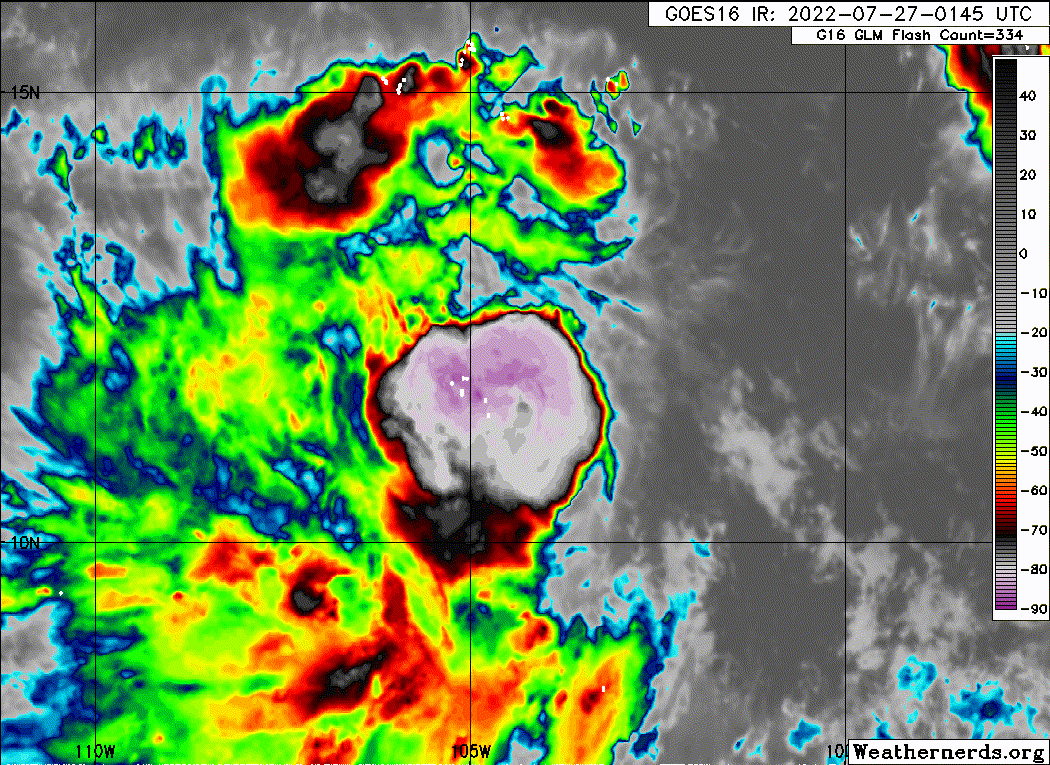
Convection near the center of Frank is struggling to organize, as
several bursts since the prior advisory have been stripped away
southwest of the center due to continued moderate northeasterly
vertical wind shear. Cirrus from a more recent convective burst is
currently covering the center. Today's scatterometer swaths just
clipped the far eastern edge of Frank's circulation, and while there
were some greater than 34-kt wind retrievals in ASCAT-B at around
1700 UTC, these values may have been rain contaminated, especially
compared to the much lower ASCAT-C values less than an hour prior.
Dvorak intensity estimates this afternoon were a consensus
T2.5/35-kt from TAFB, SAB, and ADT. The intensity will remain at 35
kt for this advisory.

The shear over Frank is not expected to abate for the next 36-48
hours, and in fact may increase a bit more as suggested by the
ECMWF-SHIPS guidance. Both the ECMWF and GFS simulated IR brightness
temperature also show convection continuing to be focused down-shear
of the low-level circulation during this time frame, limiting
intensification. One additional complicating factor is that another
system located west of Frank could also interact with the tropical
storm, though Frank should remain the dominant cyclone. Even after
the shear abates in around 3 days, it is unclear what type of storm
structure Frank will have at that time, and if it can take full
advantage of the more favorable environmental conditions. For these
reasons, the intensity forecast remains on the conservative side,
showing a pause in strengthening between 12-36 hours, and then
gradual intensification beginning afterwards. The latest intensity
forecast remains on the low end of the intensity guidance, and
remains closest to the LGEM model.

Frank continues to move just north of due west at 280/10 kt. This
general motion and heading should not change too much over the next
2-3 days as the storm remains steered by a large mid-level
subtropical ridge to its north. A weakness in the ridge thereafter,
as well as some possible interaction with the system west of Frank,
may allow the storm to gain more latitude thereafter. The track
guidance this cycle has shifted a bit north, and the latest track
forecast follows suit, located roughly between the HCCA and GFEX
aids.


FORECAST POSITIONS AND MAX WINDS

INIT 26/2100Z 11.8N 103.5W 35 KT 40 MPH
12H 27/0600Z 12.1N 104.9W 40 KT 45 MPH
24H 27/1800Z 12.5N 106.7W 40 KT 45 MPH
36H 28/0600Z 12.9N 108.5W 40 KT 45 MPH
48H 28/1800Z 13.4N 110.6W 45 KT 50 MPH
60H 29/0600Z 13.8N 112.6W 50 KT 60 MPH
72H 29/1800Z 14.3N 114.3W 60 KT 70 MPH
96H 30/1800Z 15.9N 117.1W 75 KT 85 MPH
120H 31/1800Z 18.4N 120.0W 75 KT 85 MPH

$$
Forecaster Papin
0 likes   
Visit the Caribbean-Central America Weather Thread where you can find at first post web cams,radars
and observations from Caribbean basin members Click Here

User avatar
cycloneye
Admin
Admin
Posts: 139099
Age: 67
Joined: Thu Oct 10, 2002 10:54 am
Location: San Juan, Puerto Rico

Re: EPAC: FRANK - Tropical Storm

#42 Postby cycloneye » Tue Jul 26, 2022 7:55 pm

EP, 07, 2022072700, , BEST, 0, 117N, 1038W, 35, 1004, TS
0 likes   
Visit the Caribbean-Central America Weather Thread where you can find at first post web cams,radars
and observations from Caribbean basin members Click Here

User avatar
cycloneye
Admin
Admin
Posts: 139099
Age: 67
Joined: Thu Oct 10, 2002 10:54 am
Location: San Juan, Puerto Rico

Re: EPAC: FRANK - Tropical Storm

#43 Postby cycloneye » Tue Jul 26, 2022 9:41 pm

Tropical Storm Frank Discussion Number 4
NWS National Hurricane Center Miami FL EP072022
1000 PM CDT Tue Jul 26 2022

Frank continues to form deep convective bursts near and west of the
estimated center, with cloud tops colder than -80 degrees C.
However, satellite imagery indicates this convection is not
well-organized and the system currently lacks well-defined banding
features. Subjective and objective Dvorak intensity estimates
remain at 35 kt so the there is no change to the advisory
intensity.

Northeasterly shear is inhibiting increased organization and
strengthening of the tropical storm. The shear is associated with a
strong upper-level anticyclone near northwestern Mexico. Global
model guidance predicts that this anticyclone will weaken during the
next couple of days which should result in a relaxation of the
shear. The SHIPS guidance shows the shear decreasing significantly
in 24-36 hours. It also indicates that the other oceanic and
environmental conditions will be conducive for Frank to possibly
strengthen into a hurricane within three days. The official
intensity forecast is similar to the previous prediction and
slightly below the model consensus.

The system is moving westward at 9 kt. Frank should gradually turn
to the west-northwest over the next several days as it moves along
the periphery of a mid-level ridge to the north. A more
northwestward motion is likely in 4-5 days as the cyclone nears the
western edge of the ridge. A potential complication to the track
forecast is the possible influence of a disturbance about 600 n mi
to the west-northwest of Frank. The NHC track prediction is close
to the latest model consensus aid, HCCA, and similar to the previous
advisory forecast.


FORECAST POSITIONS AND MAX WINDS

INIT 27/0300Z 11.7N 104.2W 35 KT 40 MPH
12H 27/1200Z 12.1N 105.6W 35 KT 40 MPH
24H 28/0000Z 12.5N 107.5W 40 KT 45 MPH
36H 28/1200Z 12.9N 109.5W 45 KT 50 MPH
48H 29/0000Z 13.3N 111.5W 50 KT 60 MPH
60H 29/1200Z 13.9N 113.4W 55 KT 65 MPH
72H 30/0000Z 14.5N 115.1W 65 KT 75 MPH
96H 31/0000Z 16.5N 118.1W 75 KT 85 MPH
120H 01/0000Z 18.9N 121.2W 70 KT 80 MPH

$$
Forecaster Pasch/Bucci
0 likes   
Visit the Caribbean-Central America Weather Thread where you can find at first post web cams,radars
and observations from Caribbean basin members Click Here

Sciencerocks
Category 5
Category 5
Posts: 7286
Age: 38
Joined: Thu Jul 06, 2017 1:51 am

Re: EPAC: FRANK - Tropical Storm

#44 Postby Sciencerocks » Wed Jul 27, 2022 12:26 am

Image
0 likes   

User avatar
Category5Kaiju
Category 5
Category 5
Posts: 3360
Age: 22
Joined: Thu Dec 24, 2020 12:45 pm
Location: Seattle

Re: EPAC: FRANK - Tropical Storm

#45 Postby Category5Kaiju » Wed Jul 27, 2022 1:02 am

Man, Frank is getting sheared pretty decently right now. It should strengthen down the road, but I have to wonder if at this point a modest Cat 1 is the upper limit of what it can achieve..
0 likes   
Unless explicitly stated, all information covered in my posts is based on my opinions and observations. Please refer to a professional meteorologist or an accredited weather research agency otherwise, especially if serious decisions must be made in the event of a potentially life-threatening tropical storm or hurricane.

User avatar
cycloneye
Admin
Admin
Posts: 139099
Age: 67
Joined: Thu Oct 10, 2002 10:54 am
Location: San Juan, Puerto Rico

Re: EPAC: FRANK - Tropical Storm

#46 Postby cycloneye » Wed Jul 27, 2022 4:28 am

Tropical Storm Frank Discussion Number 5
NWS National Hurricane Center Miami FL EP072022
400 AM CDT Wed Jul 27 2022

Frank remains a highly sheared tropical cyclone. Shortwave
infrared satellite imagery indicates that the center is exposed
well to the northeast of the primary convective mass. This is due
to around 25 kt of northeasterly vertical wind shear as indicated
by the SHIPS guidance. Recent ASCAT overpasses only caught the far
western portion of the circulation and they were not helpful in
estimating Frank's initial intensity. Therefore, the initial
wind speed remains at 35 kt, which is in agreement with the latest
subjective and objective Dvorak satellite intensity estimates.

The strong northeasterly shear that is plaguing Frank is not
expected to change much today. The global model guidance, however
suggests the shear will gradually abate beginning tonight with
upper-level conditions becoming more conducive for strengthening
in 24 to 36 hours. Given the current structure of the tropical
cyclone, it may take some time for the system to take advantage
of the more favorable environment. Therefore, the NHC wind speed
forecast only calls for gradual strengthening between 24 and 48
hours, with a slightly faster rate of intensification after that
time. The NHC forecast is once again on the conservative side and
lies between the SHIPS and lower LGEM model guidance.

Frank is moving westward at about 8 kt. A subtropical ridge to the
north of the cyclone should continue to steer Frank westward to
west-northwestward over the next 48 to 72 hours. After that time,
a west-northwestward to northwestward motion is forecast as the
cyclone reaches the western periphery of the ridge. The new NHC
track forecast is once again close to the multi-model consensus aids
and the GFS ensemble mean.


FORECAST POSITIONS AND MAX WINDS

INIT 27/0900Z 12.2N 104.9W 35 KT 40 MPH
12H 27/1800Z 12.4N 106.4W 35 KT 40 MPH
24H 28/0600Z 12.7N 108.4W 40 KT 45 MPH
36H 28/1800Z 13.1N 110.4W 45 KT 50 MPH
48H 29/0600Z 13.6N 112.3W 50 KT 60 MPH
60H 29/1800Z 14.4N 114.0W 60 KT 70 MPH
72H 30/0600Z 15.2N 115.8W 70 KT 80 MPH
96H 31/0600Z 17.5N 119.1W 75 KT 85 MPH
120H 01/0600Z 19.6N 122.3W 65 KT 75 MPH

$$
Forecaster Brown
0 likes   
Visit the Caribbean-Central America Weather Thread where you can find at first post web cams,radars
and observations from Caribbean basin members Click Here

User avatar
cycloneye
Admin
Admin
Posts: 139099
Age: 67
Joined: Thu Oct 10, 2002 10:54 am
Location: San Juan, Puerto Rico

Re: EPAC: FRANK - Tropical Storm

#47 Postby cycloneye » Wed Jul 27, 2022 9:52 am

Tropical Storm Frank Discussion Number 6
NWS National Hurricane Center Miami FL EP072022
1000 AM CDT Wed Jul 27 2022

Frank continues to feel the effects of about 20 kt of northeasterly
vertical wind shear, with the low-level center remaining just
northeast of the current convective burst. Various subjective and
objective satellite intensity estimates are in the 35-40 kt range,
and these have changed little since the last advisory. Based on
this, the initial intensity remains 35 kt.

The global models suggest that the current shear should ease over
the next 12-24 h and allow Frank to gradually strengthen. Between
24-72 h, the shear is forecast to become light while the cyclone is
over 28-29C sea surface temperatures, and this environment could
allow for steady, and possible rapid, intensification. The forecast
peak intensity of 75 kt is unchanged from the previous forecast due
to uncertainty as to whether Frank will have a good enough structure
to rapidly intensify. However, this is in the middle of the
intensity guidance and could be conservative. After 72 h, Frank
should move over decreasing sea surface temperatures, and this
should cause weakening.

Frank is wobbling between a westward and west-northwestward motion
with the current motion of 285/9. A subtropical ridge to the
north of the cyclone should continue to steer Frank generally
westward for the next 36 h or so, followed by a west-northwestward
motion from 36-72 h. After that time, the cyclone is expected to
moved more northwestward toward a break in the ridge caused by by a
mid- to upper-level trough developing over the Pacific west of
California. The new official forecast rack is similar to the
previous track through 60 h, and then is nudged a little to the
north of the previous forecast in response to a northward shift of
the guidance. The new forecast is close to or a little south of
the various consensus models.

It should be noted that Frank and the newly-formed Tropical
Depression Eight-E are likely to come close enough to one another to
interact. The global models suggest that Frank will be the larger
and dominant system during this interaction, and that the depression
will have only minor impacts on the track and intensity of Frank.


FORECAST POSITIONS AND MAX WINDS

INIT 27/1500Z 12.4N 105.9W 35 KT 40 MPH
12H 28/0000Z 12.7N 107.4W 35 KT 40 MPH
24H 28/1200Z 13.1N 109.4W 40 KT 45 MPH
36H 29/0000Z 13.5N 111.3W 45 KT 50 MPH
48H 29/1200Z 14.1N 112.9W 55 KT 65 MPH
60H 30/0000Z 15.0N 114.7W 65 KT 75 MPH
72H 30/1200Z 16.1N 116.3W 75 KT 85 MPH
96H 31/1200Z 18.5N 119.5W 75 KT 85 MPH
120H 01/1200Z 20.5N 123.0W 60 KT 70 MPH

$$
Forecaster Beven
0 likes   
Visit the Caribbean-Central America Weather Thread where you can find at first post web cams,radars
and observations from Caribbean basin members Click Here

Sciencerocks
Category 5
Category 5
Posts: 7286
Age: 38
Joined: Thu Jul 06, 2017 1:51 am

Re: EPAC: FRANK - Tropical Storm

#48 Postby Sciencerocks » Wed Jul 27, 2022 9:56 am

Image
0 likes   

User avatar
Yellow Evan
Professional-Met
Professional-Met
Posts: 15952
Age: 25
Joined: Fri Jul 15, 2011 12:48 pm
Location: Henderson, Nevada/Honolulu, HI
Contact:

Re: EPAC: FRANK - Tropical Storm

#49 Postby Yellow Evan » Wed Jul 27, 2022 2:29 pm

* GFS version *
* EAST PACIFIC 2021 SHIPS INTENSITY FORECAST *
* IR SAT DATA AVAILABLE, OHC AVAILABLE *
* FRANK EP072022 07/27/22 18 UTC *

TIME (HR) 0 6 12 18 24 36 48 60 72 84 96 108 120 132 144 156 168
V (KT) NO LAND 40 41 42 45 49 57 68 81 95 100 96 91 83 77 69 63 56
V (KT) LAND 40 41 42 45 49 57 68 81 95 100 96 91 83 77 69 63 56
V (KT) LGEM 40 42 44 46 48 55 66 77 86 86 76 62 52 45 40 34 29
Storm Type TROP TROP TROP TROP TROP TROP TROP TROP TROP TROP TROP TROP TROP TROP TROP TROP TROP

SHEAR (KT) 18 16 18 13 7 10 7 3 8 12 13 7 7 5 5 4 8
SHEAR ADJ (KT) 0 0 1 2 2 0 1 2 5 5 2 -2 -2 -2 -1 -6 -2
SHEAR DIR 21 8 19 32 28 22 297 64 56 64 45 75 316 285 304 192 281
SST (C) 29.2 29.6 29.7 29.5 29.3 29.1 28.8 28.5 27.9 26.8 25.3 24.1 23.3 22.6 22.1 21.3 21.2
POT. INT. (KT) 157 161 162 160 157 155 152 149 143 132 116 103 94 87 82 73 72
200 MB T (C) -53.9 -53.6 -53.9 -53.9 -53.6 -53.3 -52.6 -52.5 -52.1 -52.0 -52.3 -52.5 -52.7 -52.4 -52.8 -52.4 -52.8
200 MB VXT (C) 0.1 0.1 0.1 0.2 0.2 0.3 0.4 1.0 0.8 1.0 0.7 0.8 0.9 0.8 0.5 0.3 0.3
TH_E DEV (C) 6 7 7 7 6 6 6 5 4 3 2 2 2 2 1 1 1
700-500 MB RH 70 71 70 73 75 75 75 75 78 81 78 74 67 62 58 56 53
MODEL VTX (KT) 15 15 14 16 17 20 26 29 34 36 34 32 29 27 25 22 20
850 MB ENV VOR 20 22 28 38 47 38 49 49 42 43 37 51 37 49 49 37 15
200 MB DIV 75 70 49 79 92 114 146 105 92 78 70 75 8 20 -5 -8 -28
700-850 TADV -2 -4 -5 -2 -1 -7 -8 -7 -5 -4 -2 0 0 0 -2 0 -2
LAND (KM) 727 759 800 840 890 971 1018 1008 998 1002 1047 1127 1168 1237 1309 1391 1460
LAT (DEG N) 12.4 12.6 12.8 13.0 13.2 13.7 14.4 15.4 16.6 17.8 19.0 20.0 20.8 xx.x xx.x xx.x xx.x
LONG(DEG W) 106.3 107.3 108.2 109.3 110.3 111.9 113.6 115.4 116.8 118.4 120.3 122.1 123.6 xxx.x xxx.x xxx.x xxx.x
STM SPEED (KT) 9 9 10 10 9 8 10 9 9 10 10 9 8 8 8 7 6
HEAT CONTENT 21 22 23 23 23 21 17 16 9 2 0 0 0 0 0 0 0

FORECAST TRACK FROM OFCI INITIAL HEADING/SPEED (DEG/KT):285/ 9 CX,CY: -8/ 2
T-12 MAX WIND: 35 PRESSURE OF STEERING LEVEL (MB): 628 (MEAN=587)
GOES IR BRIGHTNESS TEMP. STD DEV. 50-200 KM RAD: 25.0 (MEAN=14.5)
% GOES IR PIXELS WITH T < -20 C 50-200 KM RAD: 61.0 (MEAN=65.0)
PRELIM RI PROB (DV .GE. 35 KT IN 36 HR): 14.8

INDIVIDUAL CONTRIBUTIONS TO INTENSITY CHANGE
6 12 18 24 36 48 60 72 84 96 108 120 132 144 156 168
------------------------------------------------------------------------------
SAMPLE MEAN CHANGE 0. 0. 1. 1. 1. 2. 1. 1. 0. -0. -1. -2. -2. -3. -4. -4.
SST POTENTIAL 0. 1. 1. 3. 6. 10. 15. 18. 20. 21. 21. 20. 17. 14. 11. 7.
VERTICAL SHEAR MAG 0. -0. -0. 0. 1. 1. 2. 3. 3. 3. 3. 4. 5. 5. 6. 6.
VERTICAL SHEAR ADJ 0. -0. -0. -0. -0. -0. -0. -1. -0. -0. -0. -0. -0. -0. -0. 0.
VERTICAL SHEAR DIR 0. 0. 1. 1. 2. 2. 3. 4. 4. 4. 3. 2. 2. 1. 1. 1.
PERSISTENCE 1. 1. 1. 1. 1. 1. 1. 1. 1. 1. 1. 1. 1. 1. 1. 1.
200/250 MB TEMP. 0. 0. 0. 0. -0. -1. -1. -1. -1. -0. 1. 2. 4. 5. 6. 6.
THETA_E EXCESS 0. 0. 0. 0. 0. 0. -0. -1. -1. -2. -3. -4. -5. -6. -7. -9.
700-500 MB RH 0. 0. 0. 0. 1. 1. 1. 1. 1. 2. 2. 2. 2. 3. 3. 4.
MODEL VTX TENDENCY -0. -1. 0. 2. 3. 10. 17. 25. 29. 25. 21. 15. 12. 9. 6. 3.
850 MB ENV VORTICITY -0. -0. 0. 0. 0. -0. -0. -0. -0. -0. -0. -0. -0. -0. -0. -0.
200 MB DIVERGENCE 0. 0. 0. 1. 1. 2. 4. 6. 6. 6. 6. 4. 3. 1. -0. -1.
850-700 T ADVEC 0. 0. 0. 0. 0. -0. -0. -0. -0. -0. -0. -0. -0. -1. -1. -1.
ZONAL STORM MOTION 0. 0. 0. 0. 0. 0. 0. 0. 0. 0. 0. 0. 0. 0. 0. -0.
STEERING LEVEL PRES 0. 0. 0. 0. 1. 1. 1. 1. 1. 1. 1. 1. 1. 1. 1. 0.
DAYS FROM CLIM. PEAK -0. -0. -0. -0. -0. -0. -0. -0. -0. -0. -0. -0. -0. -1. -1. -1.
GOES PREDICTORS -1. -1. -2. -2. -2. -2. -2. -2. -2. -2. -3. -3. -3. -2. -2. -1.
OCEAN HEAT CONTENT 0. 0. 0. 0. 0. 0. 0. 0. -0. -0. 0. 0. 1. 1. 2. 3.
RI POTENTIAL 0. 0. 1. 1. 1. 1. 0. -0. 0. 0. 1. 1. 1. 1. 1. 1.
------------------------------------------------------------------------------
TOTAL CHANGE 1. 2. 5. 9. 17. 28. 41. 55. 60. 56. 51. 43. 37. 29. 23. 16.

CURRENT MAX WIND (KT): 40. LAT, LON: 12.4 106.3

** 2021 E. Pacific RI INDEX EP072022 FRANK 07/27/22 18 UTC **
(SHIPS-RII PREDICTOR TABLE for 30 KT OR MORE MAXIMUM WIND INCREASE IN NEXT 24-h)

Predictor Value RI Predictor Range Scaled Value(0-1) % Contribution
POT = MPI-VMAX (KT) : 119.4 40.5 to 149.3 0.73 5.4
12 HR PERSISTENCE (KT) : 5.0 -22.0 to 44.0 0.41 3.5
D200 (10**7s-1) : 73.0 -33.0 to 159.5 0.55 3.8
850-200 MB SHEAR (KT) : 14.2 19.6 to 1.3 0.30 2.0
MAXIMUM WIND (KT) : 40.0 22.5 to 132.0 0.50 2.6
STD DEV OF IR BR TEMP : 25.0 37.8 to 2.1 0.36 1.7
BL DRY-AIR FLUX (W/M2) : 91.0 800.8 to -82.5 0.80 -4.2
HEAT CONTENT (KJ/CM2) : 22.4 2.7 to 106.7 0.19 0.8
%area of TPW <45 mm upshear : 0.0 56.6 to 0.0 1.00 1.5
2nd PC OF IR BR TEMP : -2.2 2.2 to -2.3 0.97 0.8

SHIPS Prob RI for 20kt/ 12hr RI threshold= 7% is 1.1 times climatological mean ( 6.3%)
SHIPS Prob RI for 25kt/ 24hr RI threshold= 20% is 1.6 times climatological mean (12.5%)
SHIPS Prob RI for 30kt/ 24hr RI threshold= 18% is 2.1 times climatological mean ( 8.6%)
SHIPS Prob RI for 35kt/ 24hr RI threshold= 17% is 2.8 times climatological mean ( 6.2%)
SHIPS Prob RI for 40kt/ 24hr RI threshold= 0% is 0.0 times climatological mean ( 4.2%)
SHIPS Prob RI for 45kt/ 36hr RI threshold= 19% is 2.8 times climatological mean ( 6.7%)
SHIPS Prob RI for 55kt/ 48hr RI threshold= 32% is 5.4 times climatological mean ( 5.9%)
SHIPS Prob RI for 65kt/ 72hr RI threshold= 41% is 8.7 times climatological mean ( 4.7%)

Matrix of RI probabilities
------------------------------------------------------------------------------
RI (kt / h) | 20/12 | 25/24 | 30/24 | 35/24 | 40/24 | 45/36 | 55/48 |65/72
------------------------------------------------------------------------------
SHIPS-RII: 7.0% 20.1% 17.9% 17.1% 0.0% 18.9% 31.8% 41.0%
Logistic: 0.6% 6.2% 2.7% 1.1% 0.4% 3.4% 11.8% 8.2%
Bayesian: 0.4% 0.2% 0.0% 0.0% 0.0% 0.1% 2.7% 10.0%
Consensus: 2.7% 8.8% 6.9% 6.1% 0.1% 7.5% 15.4% 19.8%
DTOPS: 0.0% 8.0% 4.0% 3.0% 2.0% 5.0% 7.0% 6.0%

## ANNULAR HURRICANE INDEX (AHI) EP072022 FRANK 07/27/22 18 UTC ##
## STORM NOT ANNULAR, SCREENING STEP FAILED, NPASS=3 NFAIL=4 ##
## AHI= 0 (AHI OF 100 IS BEST FIT TO ANN. STRUC., 1 IS MARGINAL, 0 IS NOT ANNULAR) ##
0 likes   

User avatar
Yellow Evan
Professional-Met
Professional-Met
Posts: 15952
Age: 25
Joined: Fri Jul 15, 2011 12:48 pm
Location: Henderson, Nevada/Honolulu, HI
Contact:

Re: EPAC: FRANK - Tropical Storm

#50 Postby Yellow Evan » Wed Jul 27, 2022 2:42 pm

TXPZ28 KNES 271810
TCSENP

A. 07E (FRANK)

B. 27/1730Z

C. 12.4N

D. 106.2W

E. THREE/GOES-E

F. T3.0/3.0

G. IR/EIR/VIS

H. REMARKS...AN LLCC LOCATED LESS THAN 1/3 DEG INTO THE COLD OVERCAST
RESULTS IN DT OF 3.0. THE MET IS 3.5 AND PT IS 3.0. THE FT IS BASED ON
THE PT BASED ON THE PULSING CONVECTION.

I. ADDL POSITIONS

NIL


...BROWN
0 likes   

Sciencerocks
Category 5
Category 5
Posts: 7286
Age: 38
Joined: Thu Jul 06, 2017 1:51 am

Re: EPAC: FRANK - Tropical Storm

#51 Postby Sciencerocks » Wed Jul 27, 2022 2:44 pm

Image
0 likes   

User avatar
cycloneye
Admin
Admin
Posts: 139099
Age: 67
Joined: Thu Oct 10, 2002 10:54 am
Location: San Juan, Puerto Rico

Re: EPAC: FRANK - Tropical Storm

#52 Postby cycloneye » Wed Jul 27, 2022 3:45 pm

Tropical Storm Frank Discussion Number 7
NWS National Hurricane Center Miami FL EP072022
300 PM MDT Wed Jul 27 2022

While Frank continues to feel the effects of northeasterly vertical
wind shear, the shear seem to have diminished a little and the
convection has become a little more concentrated just southwest of
the low-level center. The various subjective and objective
satellite intensity estimates are in the 35-45 kt range and have
nudged a little upward since the last advisory. Thus, the initial
intensity is increased to 40 kt in best agreement with the CIMSS
satellite consensus estimate.

The global models suggest that the current shear should ease over
the next 12-18 h and allow Frank to gradually strengthen. Between
18-72 h, the shear is forecast to become light while the cyclone is
over 28-29C sea surface temperatures, and this environment could
allow for steady, and possibly rapid, intensification. The
intensity guidance now shows more strengthening than the runs 6 h
ago, and based on this the first 96 h of the intensity forecast
have been revised upward. It should be noted that the new forecast
peak intensity of 85 kt could be conservative, as the SHIPS, HFIP
Corrected Consensus, HMON, and COAMPS-TC models all forecast a
higher peak intensity. After 72 h, the cyclone should move over
cooler waters, and this should cause a steady weakening.

Frank is now moving westward with an initial motion of 280/9. A
subtropical ridge to the north of the cyclone should continue to
steer Frank generally westward for the next 24-36 h, followed by a
west-northwestward motion. After 72 h, the cyclone is expected to
moved more northwestward toward a break in the ridge caused by by a
mid- to upper-level trough developing over the Pacific west of
California. The new official forecast track is similar to the
previous track through 60 h, and then is again nudged a little to
the north of the previous forecast. The new forecast is again
close to or a little south of the various consensus models.

It should be noted that Frank and Tropical Storm Georgette are
likely to come close enough to one another to interact. The global
models still suggest that Frank will be the larger and dominant
system during this interaction, and that Georgette will have only
minor impacts on the track and intensity of Frank.


FORECAST POSITIONS AND MAX WINDS

INIT 27/2100Z 12.5N 106.8W 40 KT 45 MPH
12H 28/0600Z 12.7N 108.3W 45 KT 50 MPH
24H 28/1800Z 13.1N 110.3W 50 KT 60 MPH
36H 29/0600Z 13.7N 112.1W 60 KT 70 MPH
48H 29/1800Z 14.6N 113.8W 70 KT 80 MPH
60H 30/0600Z 15.5N 115.6W 80 KT 90 MPH
72H 30/1800Z 16.6N 117.2W 85 KT 100 MPH
96H 31/1800Z 19.0N 120.5W 75 KT 85 MPH
120H 01/1800Z 21.0N 123.5W 55 KT 65 MPH

$$
Forecaster Beven
0 likes   
Visit the Caribbean-Central America Weather Thread where you can find at first post web cams,radars
and observations from Caribbean basin members Click Here

User avatar
cycloneye
Admin
Admin
Posts: 139099
Age: 67
Joined: Thu Oct 10, 2002 10:54 am
Location: San Juan, Puerto Rico

Re: EPAC: FRANK - Tropical Storm

#53 Postby cycloneye » Wed Jul 27, 2022 7:46 pm

EP, 07, 2022072800, , BEST, 0, 126N, 1075W, 45, 1000, TS
0 likes   
Visit the Caribbean-Central America Weather Thread where you can find at first post web cams,radars
and observations from Caribbean basin members Click Here

User avatar
Yellow Evan
Professional-Met
Professional-Met
Posts: 15952
Age: 25
Joined: Fri Jul 15, 2011 12:48 pm
Location: Henderson, Nevada/Honolulu, HI
Contact:

Re: EPAC: FRANK - Tropical Storm

#54 Postby Yellow Evan » Wed Jul 27, 2022 8:35 pm

TXPZ28 KNES 280012
TCSENP

A. 07E (FRANK)

B. 27/2330Z

C. 12.6N

D. 107.6W

E. THREE/GOES-E

F. T3.0/3.0

G. IR/EIR/VIS

H. REMARKS...SYSTEM CHARACTERIZED BY SHEAR WITH A LLCC LOCATED LESS
THAN 1/3 DEG INTO DG. DT=3.0 MET=3.5 PT=3.0. THE FT IS BASED ON THE DT.

I. ADDL POSITIONS

NIL


...FISHER
0 likes   

User avatar
cycloneye
Admin
Admin
Posts: 139099
Age: 67
Joined: Thu Oct 10, 2002 10:54 am
Location: San Juan, Puerto Rico

Re: EPAC: FRANK - Tropical Storm

#55 Postby cycloneye » Wed Jul 27, 2022 9:38 pm

Tropical Storm Frank Discussion Number 8
NWS National Hurricane Center Miami FL EP072022
900 PM MDT Wed Jul 27 2022

Deep convection persists to the southwest of the center of Frank
due to moderate northeasterly vertical wind shear. Cold cloud
top temperatures currently range between -80 to -90 degrees C and
the low-level center remains partially exposed. The initial
intensity has been nudged up to 45 kt in agreement with subjective
Dvorak intensity estimates from SAB and TAFB.

Global model guidance predicts that the vertical wind shear
currently reducing the rate of strengthening should subside over the
tropical storm within the next day. The relaxation of the shear,
warm ocean surface waters, and a moist atmospheric environment
should allow Frank to strengthen more quickly, potentially at a
rapid rate, between 36-72 h. The peak intensity of the official
forecast has been increased slightly to 90 kt at 60 h to reflect
this possibility. Beyond 72 h, Frank is expected steadily weaken
when it moves over cooler waters and into a more stable atmospheric
environment.

Frank is being steered westward at 10 kt by a subtropical ridge to
the north. In a day or so, the storm should gradually turn
west-northwestward to northwestward along the periphery of the
weakening ridge through the end of the forecast period. The latest
NHC track forecast is similar to the previous advisory track and
closest to the dynamical model consensus aid, TVCE.

It should be noted that Frank and Tropical Storm Georgette are
likely to come close enough to one another to interact. The global
models still suggest that Frank will be the larger and dominant
system during this interaction, and that Georgette will have only
minor impacts on the track and intensity of Frank.


FORECAST POSITIONS AND MAX WINDS

INIT 28/0300Z 12.7N 108.0W 45 KT 50 MPH
12H 28/1200Z 13.0N 109.4W 50 KT 60 MPH
24H 29/0000Z 13.5N 111.3W 55 KT 65 MPH
36H 29/1200Z 14.3N 113.0W 65 KT 75 MPH
48H 30/0000Z 15.2N 114.8W 75 KT 85 MPH
60H 30/1200Z 16.3N 116.6W 90 KT 105 MPH
72H 31/0000Z 17.4N 118.3W 85 KT 100 MPH
96H 01/0000Z 19.8N 121.5W 70 KT 80 MPH
120H 02/0000Z 21.9N 124.3W 55 KT 65 MPH

$$
Forecaster Bucci/Pasch
0 likes   
Visit the Caribbean-Central America Weather Thread where you can find at first post web cams,radars
and observations from Caribbean basin members Click Here

User avatar
cycloneye
Admin
Admin
Posts: 139099
Age: 67
Joined: Thu Oct 10, 2002 10:54 am
Location: San Juan, Puerto Rico

Re: EPAC: FRANK - Tropical Storm

#56 Postby cycloneye » Thu Jul 28, 2022 4:27 am

Tropical Storm Frank Discussion Number 9
NWS National Hurricane Center Miami FL EP072022
300 AM MDT Thu Jul 28 2022

Frank remains a sheared tropical cyclone with the center located
near the northeastern edge of a large and persistent convective
mass. Both the ASCAT B and C instruments once again only caught
the outer portion of Frank's circulation and did not provide
assistance in determining the intensity or size of the storm's wind
field. The latest subjective Dvorak T-numbers from SAB and TAFB
remained T3.0, which supports maintaining an initial intensity
of 45 kt.

The wind shear over Frank has decreased slightly over the past 24
hours, and a more significant reduction in shear is anticipated
within the next day or so. The reduction in shear along with SSTs
of 28 to 29C should allow Frank to strengthen more quickly
beginning later today. By 36 h, the upper-level wind pattern is
forecast to become much more favorable and a period of rapid
strengthening could occur during that time. The NHC forecast
follows the higher HCCA and FSU Superensemble guidance, and is
just above the peak intensity predicted by the SHIPS model.
After 72 hours, Frank will be moving over cooler waters and into
less favorable thermodynamic conditions which is expected to result
in steady weakening.

Frank continues to move westward at about 10 kt. The track
forecast reasoning remains unchanged from the previous advisory.
Frank is forecast to gradually turn west-northwestward to
northwestward over the next few days as it nears the western
periphery of the subtropical ridge. The track guidance is in better
agreement than it has been, but the overall track envelope is
slightly more northward which has result in a slight poleward
adjustment to the official forecast.

It should be noted that Frank and Tropical Storm Georgette are
likely to come close enough to one another to interact. The global
models still suggest that Frank will be the larger and dominant
system during this interaction, and that Georgette will have only
minor impacts on the track and intensity of Frank.


FORECAST POSITIONS AND MAX WINDS

INIT 28/0900Z 12.9N 108.9W 45 KT 50 MPH
12H 28/1800Z 13.3N 110.3W 50 KT 60 MPH
24H 29/0600Z 14.0N 112.0W 60 KT 70 MPH
36H 29/1800Z 14.9N 113.7W 70 KT 80 MPH
48H 30/0600Z 16.0N 115.5W 80 KT 90 MPH
60H 30/1800Z 17.2N 117.4W 90 KT 105 MPH
72H 31/0600Z 18.5N 119.1W 85 KT 100 MPH
96H 01/0600Z 20.7N 122.3W 65 KT 75 MPH
120H 02/0600Z 22.7N 125.0W 50 KT 60 MPH

$$
Forecaster Brown
0 likes   
Visit the Caribbean-Central America Weather Thread where you can find at first post web cams,radars
and observations from Caribbean basin members Click Here

User avatar
cycloneye
Admin
Admin
Posts: 139099
Age: 67
Joined: Thu Oct 10, 2002 10:54 am
Location: San Juan, Puerto Rico

Re: EPAC: FRANK - Tropical Storm

#57 Postby cycloneye » Thu Jul 28, 2022 9:45 am

Tropical Storm Frank Discussion Number 10
NWS National Hurricane Center Miami FL EP072022
900 AM MDT Thu Jul 28 2022

Conventional satellite imagery this morning suggests that the
northeasterly shear over Frank is diminishing, with some cirrus
outflow developing in the northeastern quadrant. However, SSM/IS
microwave overpasses at 1144 and 1234 UTC show that the storm has
not yet become better organized, as the center is still located to
the northeast of the main convective bands. Various satellite
intensity estimates range from 35-55 kt, and given the unchanged
organization the initial intensity is held at 45 kt.

A further reduction in the shear appears likely later today, which
along with sea surface temperatures of 28-29C, should allow steady
to possible rapid strengthening through the 60 h point. The new
intensity forecast continues to call for a peak intensity of 90 kt,
and this is at the upper edge of the intensity guidance. After
60 h, while the shear is forecast to remain light, the cyclone
should move over steadily decreasing SSTs, reaching 21C water by
120 h. This should cause a steady to rapid weakening. This part
of the intensity forecast has been adjusted downward and it lies
near the intensity consensus aids.

Frank continues to move westward with the initial motion 280/11 kt.
The track forecast reasoning is again unchanged from the previous
advisory. A turn toward the west-northwest is expected during the
next 12-24 h, followed by a northwestward motion as the cyclone
heads for a break in the subtropical ridge produced by mid- to
upper-level troughing over the northeastern Pacific. The track
guidance remains in good agreement, but it has again shifted just
a little to the north after about 36 h. Thus, the new track
forecast is nudged a little northward during that time.

It should be noted that Frank and Tropical Storm Georgette are
likely to come close enough to one another to interact. The global
models still suggest that Frank will be the larger and dominant
system during this interaction, and that Georgette will have only
minor impacts on the track and intensity of Frank.


FORECAST POSITIONS AND MAX WINDS

INIT 28/1500Z 13.2N 110.0W 45 KT 50 MPH
12H 29/0000Z 13.6N 111.3W 50 KT 60 MPH
24H 29/1200Z 14.4N 112.9W 60 KT 70 MPH
36H 30/0000Z 15.5N 114.7W 70 KT 80 MPH
48H 30/1200Z 16.7N 116.5W 80 KT 90 MPH
60H 31/0000Z 17.9N 118.3W 90 KT 105 MPH
72H 31/1200Z 19.1N 120.1W 85 KT 100 MPH
96H 01/1200Z 21.5N 123.5W 60 KT 70 MPH
120H 02/1200Z 23.5N 126.0W 40 KT 45 MPH

$$
Forecaster Beven
0 likes   
Visit the Caribbean-Central America Weather Thread where you can find at first post web cams,radars
and observations from Caribbean basin members Click Here

User avatar
MHC Tracking
Tropical Storm
Tropical Storm
Posts: 169
Joined: Mon Mar 15, 2021 10:05 am

Re: EPAC: FRANK - Tropical Storm

#58 Postby MHC Tracking » Thu Jul 28, 2022 11:24 am

Outflow slowly expanding as shear continues to relax over the storm. should be able to undergo significant intensification (possibly rapid at times) starting tonight as shear drops to near 10 kt
Image
1 likes   

Sciencerocks
Category 5
Category 5
Posts: 7286
Age: 38
Joined: Thu Jul 06, 2017 1:51 am

Re: EPAC: FRANK - Tropical Storm

#59 Postby Sciencerocks » Thu Jul 28, 2022 11:37 am

Image
2 likes   

User avatar
ElectricStorm
Category 5
Category 5
Posts: 4562
Age: 23
Joined: Tue Aug 13, 2019 11:23 pm
Location: Skiatook, OK / Norman, OK

Re: EPAC: FRANK - Tropical Storm

#60 Postby ElectricStorm » Thu Jul 28, 2022 1:23 pm

Still dealing with some shear but overall it looks like it's starting to get better organized. Maybe this will prove my initial prediction wrong and become a solid hurricane.
0 likes   
I am in no way a professional. Take what I say with a grain of salt as I could be totally wrong. Please refer to the NHC, NWS, or SPC for official information.

Boomer Sooner!


Return to “2022”

Who is online

Users browsing this forum: No registered users and 14 guests