EPAC: FRANK - Post-Tropical

Moderator: S2k Moderators

Message
Author
User avatar
cycloneye
Admin
Admin
Posts: 139021
Age: 67
Joined: Thu Oct 10, 2002 10:54 am
Location: San Juan, Puerto Rico

Re: EPAC: FRANK - Tropical Storm

#81 Postby cycloneye » Fri Jul 29, 2022 10:38 am

Tropical Storm Frank Discussion Number 14
NWS National Hurricane Center Miami FL EP072022
900 AM MDT Fri Jul 29 2022

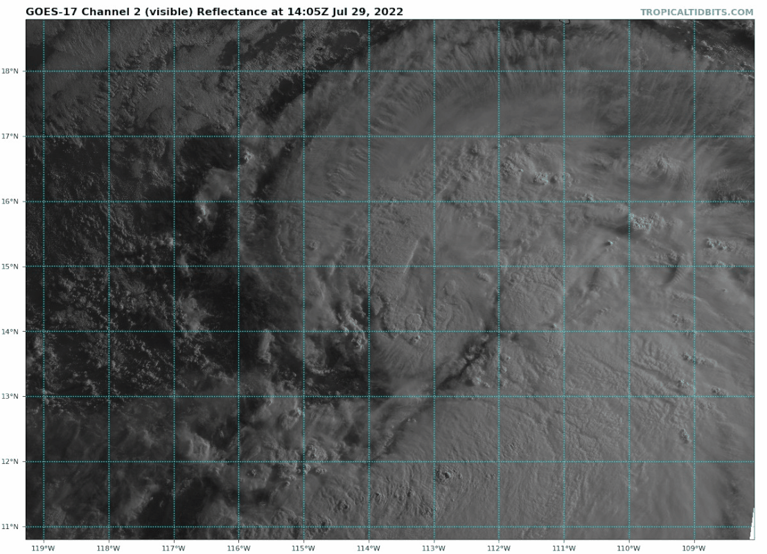
In infrared imagery, Frank's appearance has not changed much since
the last advisory. While the system shows a large curved
convective band that wraps a little more than three-quarters of the
way around the center, the central deep convection is a bit ragged,
possibly due to dry air entrainment from the northwest. However,
recent 37 GHz microwave data shows the cyclone has developed a
good low-level structure, with a ring of shallow to moderate
convection surrounding a 40 n mi wide developing eye. Satellite
intensity estimates have changed little since the previous
advisory, so the initial intensity remains 55 kt.

Frank will be in an environment of light vertical shear and over
sea surface temperatures of 28-29C for the next 36 h, and the
inner-core structure seen in the microwave imagery favors a faster
rate of strengthening. The one current negative factor is the dry
air entrainment that is causing the inner core deep convection to
sputter. The intensity forecast assumes strengthening will resume
as the deep convection will becomes persistent, and it follows the
trend of the intensity guidance in calling for a peak intensity of
90 kt in 36 h. After that time, Frank should move over
progressively cooler SSTs, with the system reaching 21C water by
120 h. This should cause steady to rapid weakening, and Frank is
forecast to become a remnant low by the end of the forecast period.

The initial motion is now 300/10 kt. Frank is moving along the
southwest side of the subtropical ridge over northwestern Mexico,
and it should move generally northwestward during the forecast
period toward a developing break in the ridge west of California.
The track guidance is in good agreement with this scenario and has
changed little since the previous advisory. Thus, the new forecast
track is an update of the previous forecast.

It again should be noted that Frank and Tropical Storm Georgette
are expected to come close enough to one another for some
interaction. Frank will be the larger and dominant system during
this interaction, and Georgette will have little impact on the track
or intensity of Frank.


FORECAST POSITIONS AND MAX WINDS

INIT 29/1500Z 14.2N 113.0W 55 KT 65 MPH
12H 30/0000Z 15.3N 114.3W 65 KT 75 MPH
24H 30/1200Z 16.5N 116.1W 80 KT 90 MPH
36H 31/0000Z 17.7N 117.9W 90 KT 105 MPH
48H 31/1200Z 18.9N 119.6W 85 KT 100 MPH
60H 01/0000Z 20.2N 121.2W 75 KT 85 MPH
72H 01/1200Z 21.5N 122.8W 65 KT 75 MPH
96H 02/1200Z 24.0N 126.0W 40 KT 45 MPH
120H 03/1200Z 26.0N 128.5W 25 KT 30 MPH...POST-TROP/REMNT LOW

$$
Forecaster Beven
0 likes   
Visit the Caribbean-Central America Weather Thread where you can find at first post web cams,radars
and observations from Caribbean basin members Click Here

User avatar
Yellow Evan
Professional-Met
Professional-Met
Posts: 15951
Age: 25
Joined: Fri Jul 15, 2011 12:48 pm
Location: Henderson, Nevada/Honolulu, HI
Contact:

Re: EPAC: FRANK - Tropical Storm

#82 Postby Yellow Evan » Fri Jul 29, 2022 12:56 pm

Image

Much better. Convection actually wrapping around now.
4 likes   

User avatar
Yellow Evan
Professional-Met
Professional-Met
Posts: 15951
Age: 25
Joined: Fri Jul 15, 2011 12:48 pm
Location: Henderson, Nevada/Honolulu, HI
Contact:

Re: EPAC: FRANK - Tropical Storm

#83 Postby Yellow Evan » Fri Jul 29, 2022 1:54 pm

EP, 07, 202207291800, 10, DVTS, CI, , 1450N, 11330W, , 2, 55, 2, 994, 2, DVRK, , , , , , , , , , , , , , E, TAFB, JA, VI, 3, 3535 /////, , , GOES17, CSC, T, Curved banding features have become more tightly coi


How can you get a 3.5 on a TC with a clearing eye?
0 likes   

User avatar
ElectricStorm
Category 5
Category 5
Posts: 4523
Age: 23
Joined: Tue Aug 13, 2019 11:23 pm
Location: Skiatook, OK / Norman, OK

Re: EPAC: FRANK - Tropical Storm

#84 Postby ElectricStorm » Fri Jul 29, 2022 1:55 pm

Looking really good now, raw Ts are up to 5.9 already...
0 likes   
I am in no way a professional. Take what I say with a grain of salt as I could be totally wrong. Please refer to the NHC, NWS, or SPC for official information.

Boomer Sooner!

User avatar
Yellow Evan
Professional-Met
Professional-Met
Posts: 15951
Age: 25
Joined: Fri Jul 15, 2011 12:48 pm
Location: Henderson, Nevada/Honolulu, HI
Contact:

Re: EPAC: FRANK - Tropical Storm

#85 Postby Yellow Evan » Fri Jul 29, 2022 1:56 pm

TXPZ28 KNES 291812
TCSENP

A. 07E (FRANK)

B. 29/1730Z

C. 14.7N

D. 113.3W

E. ONE/GOES-W

F. T4.5/4.5

G. IR/EIR/VIS/SSMIS/GMI

H. REMARKS...DG EYE IS SURROUNDED BY B AND EMBEDDED IN MG RESULTING IN
A DT OF 4.5 WITH NO EYE ADJUSTMENT. MET AND PT ARE 4.0. THE FT IS BASED
ON THE DT.

I. ADDL POSITIONS

29/1133Z 14.2N 112.5W SSMIS
29/1432Z 14.2N 112.8W GMI


...TURK
0 likes   

User avatar
cycloneye
Admin
Admin
Posts: 139021
Age: 67
Joined: Thu Oct 10, 2002 10:54 am
Location: San Juan, Puerto Rico

Re: EPAC: FRANK - Tropical Storm

#86 Postby cycloneye » Fri Jul 29, 2022 1:57 pm

EP, 07, 2022072918, , BEST, 0, 145N, 1133W, 60, 989, TS
0 likes   
Visit the Caribbean-Central America Weather Thread where you can find at first post web cams,radars
and observations from Caribbean basin members Click Here

User avatar
cycloneye
Admin
Admin
Posts: 139021
Age: 67
Joined: Thu Oct 10, 2002 10:54 am
Location: San Juan, Puerto Rico

Re: EPAC: FRANK - Tropical Storm

#87 Postby cycloneye » Fri Jul 29, 2022 2:05 pm

0 likes   
Visit the Caribbean-Central America Weather Thread where you can find at first post web cams,radars
and observations from Caribbean basin members Click Here

User avatar
Teban54
Category 5
Category 5
Posts: 1949
Joined: Sat May 19, 2018 1:19 pm

Re: EPAC: FRANK - Tropical Storm

#88 Postby Teban54 » Fri Jul 29, 2022 2:09 pm

Looks like Frank's time has finally come.
Image
0 likes   

User avatar
cycloneye
Admin
Admin
Posts: 139021
Age: 67
Joined: Thu Oct 10, 2002 10:54 am
Location: San Juan, Puerto Rico

Re: EPAC: FRANK - Tropical Storm

#89 Postby cycloneye » Fri Jul 29, 2022 3:35 pm

Tropical Storm Frank Discussion Number 15
NWS National Hurricane Center Miami FL EP072022
300 PM MDT Fri Jul 29 2022

Frank has become better organized during the past several hours,
with increased convective banding close to the center and signs of
a ragged eye forming. However, the convection in the formative
eyewall is still a bit sporadic, likely due to some continued dry
air entrainment. Satellite intensity estimates have increased to
the 50-77 kt range, and recent ASCAT-B scatterometer data showed
winds of at least 50 kt northeast of the center. Based on these
data, the initial intensity is set at 60 kt. The wind radii have
been modified using the ASCAT-B data.

Frank will be in an environment of light vertical shear and over
sea surface temperatures of 28-29C for the next 24-36 h, and
this combined with the increasing organization in the inner core
favors continued strengthening. The new intensity forecast calls
for a peak intensity of 90 kt in 36 h, and this lies at the top of
the intensity guidance. However, the rapid intensification indices
of the SHIPS model call for about a 65 percent chance of 25-30 kt
of strengthening in just the next 24 h, so it is possible the
current forecast is conservative. After 36 h, Frank should move
over progressively cooler SSTs, with the system reaching 21C water
by 96 h. This should cause steady to rapid weakening, and Frank is
forecast to become a remnant low by the end of the forecast period.

The initial motion is now 305/10 kt. Frank is moving along the
southwest side of the subtropical ridge over northwestern Mexico,
and it should move generally northwestward during the forecast
period toward a developing break in the ridge west of California.
The track guidance remains in good agreement with this scenario and
has again changed little since the previous advisory. Thus, the new
forecast track is once again an update of the previous forecast.

It again should be noted that Frank and Tropical Storm Georgette
are expected to come close enough to one another for some
interaction. Frank will be the larger and dominant system during
this interaction, and the smaller and weaker Georgette will have
little impact on the track or intensity of Frank.


FORECAST POSITIONS AND MAX WINDS

INIT 29/2100Z 14.8N 113.8W 60 KT 70 MPH
12H 30/0600Z 15.6N 115.0W 70 KT 80 MPH
24H 30/1800Z 16.8N 116.8W 80 KT 90 MPH
36H 31/0600Z 18.0N 118.4W 90 KT 105 MPH
48H 31/1800Z 19.3N 120.0W 85 KT 100 MPH
60H 01/0600Z 20.6N 121.6W 70 KT 80 MPH
72H 01/1800Z 21.9N 123.2W 60 KT 70 MPH
96H 02/1800Z 24.0N 126.0W 35 KT 40 MPH
120H 03/1800Z 26.0N 128.5W 25 KT 30 MPH...POST-TROP/REMNT LOW

$$
Forecaster Beven
0 likes   
Visit the Caribbean-Central America Weather Thread where you can find at first post web cams,radars
and observations from Caribbean basin members Click Here

User avatar
aspen
Category 5
Category 5
Posts: 8055
Joined: Sat Oct 12, 2019 7:10 pm
Location: Connecticut, USA

Re: EPAC: FRANK - Tropical Storm

#90 Postby aspen » Fri Jul 29, 2022 4:29 pm

Pretty good structural evolution today. That massive band is waning, and there are two very deep hot towers rotating around the LLC. This is probably a low-end hurricane right now and could become a Cat 2 if dry air intrusions don’t disrupt the forming eyewall.
0 likes   
Irene '11 Sandy '12 Hermine '16 5/15/2018 Derecho Fay '20 Isaias '20 Elsa '21 Henri '21 Ida '21

I am only a meteorology enthusiast who knows a decent amount about tropical cyclones. Look to the professional mets, the NHC, or your local weather office for the best information.

Ntxw
Storm2k Moderator
Storm2k Moderator
Posts: 21492
Joined: Wed Oct 21, 2009 6:34 pm
Location: DFW, Texas

Re: EPAC: FRANK - Tropical Storm

#91 Postby Ntxw » Fri Jul 29, 2022 6:44 pm

Nascent eye trying. Should be a good show tomorrow if it can keep it up.
0 likes   
The above post and any post by Ntxw is NOT an official forecast and should not be used as such. It is just the opinion of the poster and may or may not be backed by sound meteorological data. It is NOT endorsed by any professional institution including Storm2k. For official information, please refer to NWS products.

  Help support Storm2K!
Help Support Storm2K

User avatar
Yellow Evan
Professional-Met
Professional-Met
Posts: 15951
Age: 25
Joined: Fri Jul 15, 2011 12:48 pm
Location: Henderson, Nevada/Honolulu, HI
Contact:

Re: EPAC: FRANK - Tropical Storm

#92 Postby Yellow Evan » Fri Jul 29, 2022 6:44 pm

0 likes   

User avatar
Yellow Evan
Professional-Met
Professional-Met
Posts: 15951
Age: 25
Joined: Fri Jul 15, 2011 12:48 pm
Location: Henderson, Nevada/Honolulu, HI
Contact:

Re: EPAC: FRANK - Tropical Storm

#93 Postby Yellow Evan » Fri Jul 29, 2022 6:45 pm

Image

T5.5.
2 likes   

User avatar
Yellow Evan
Professional-Met
Professional-Met
Posts: 15951
Age: 25
Joined: Fri Jul 15, 2011 12:48 pm
Location: Henderson, Nevada/Honolulu, HI
Contact:

Re: EPAC: FRANK - Tropical Storm

#94 Postby Yellow Evan » Fri Jul 29, 2022 7:09 pm

0 likes   

Astromanía
Category 2
Category 2
Posts: 737
Age: 25
Joined: Sat Aug 25, 2018 10:34 pm
Location: Monterrey, N.L, México

Re: EPAC: FRANK - Tropical Storm

#95 Postby Astromanía » Fri Jul 29, 2022 7:41 pm

How it's not still a hurricane
Last edited by Astromanía on Fri Jul 29, 2022 7:43 pm, edited 1 time in total.
0 likes   

User avatar
DorkyMcDorkface
Category 2
Category 2
Posts: 692
Age: 26
Joined: Mon Sep 30, 2019 1:32 pm
Location: Mid-Atlantic

Re: EPAC: FRANK - Tropical Storm

#96 Postby DorkyMcDorkface » Fri Jul 29, 2022 7:42 pm

Astromanía wrote:How it's not still an hurricane

ATCF updated, it is:
EP, 07, 2022073000, , BEST, 0, 148N, 1144W, 70, 983, HU
3 likes   
Floyd 1999 | Isabel 2003 | Hanna 2008 | Irene 2011 | Sandy 2012 | Isaias 2020

User avatar
Yellow Evan
Professional-Met
Professional-Met
Posts: 15951
Age: 25
Joined: Fri Jul 15, 2011 12:48 pm
Location: Henderson, Nevada/Honolulu, HI
Contact:

Re: EPAC: FRANK - Tropical Storm

#97 Postby Yellow Evan » Fri Jul 29, 2022 7:45 pm

TXPZ28 KNES 300021
TCSENP

A. 07E (FRANK)

B. 29/2330Z

C. 14.8N

D. 114.3W

E. ONE/GOES-W

F. T4.5/4.5

G. IR/EIR/VIS

H. REMARKS...CLOUD-FILLED MG EYE SURROUNDED BY B AND EMBEDDED IN LG
RESULTS IN AN E# OF 5.0 WITH EADJ -0.5 FOR A DT OF 4.5. MET AND PT=4.5. FT
IS BASED DT.

I. ADDL POSITIONS

NIL


...KONON


No eye adjustment here per the Dvorak 1984 table so this appears to be an error.
0 likes   

User avatar
Yellow Evan
Professional-Met
Professional-Met
Posts: 15951
Age: 25
Joined: Fri Jul 15, 2011 12:48 pm
Location: Henderson, Nevada/Honolulu, HI
Contact:

Re: EPAC: FRANK - Tropical Storm

#98 Postby Yellow Evan » Fri Jul 29, 2022 7:50 pm

0 likes   

User avatar
Yellow Evan
Professional-Met
Professional-Met
Posts: 15951
Age: 25
Joined: Fri Jul 15, 2011 12:48 pm
Location: Henderson, Nevada/Honolulu, HI
Contact:

Re: EPAC: FRANK - Tropical Storm

#99 Postby Yellow Evan » Fri Jul 29, 2022 7:52 pm

0 likes   

User avatar
Yellow Evan
Professional-Met
Professional-Met
Posts: 15951
Age: 25
Joined: Fri Jul 15, 2011 12:48 pm
Location: Henderson, Nevada/Honolulu, HI
Contact:

Re: EPAC: FRANK - Tropical Storm

#100 Postby Yellow Evan » Fri Jul 29, 2022 8:40 pm

0 likes   


Return to “2022”

Who is online

Users browsing this forum: No registered users and 24 guests