EPAC: FRANK - Post-Tropical

Moderator: S2k Moderators

Message
Author
User avatar
Yellow Evan
Professional-Met
Professional-Met
Posts: 15951
Age: 25
Joined: Fri Jul 15, 2011 12:48 pm
Location: Henderson, Nevada/Honolulu, HI
Contact:

Re: EPAC: FRANK - Tropical Storm

#101 Postby Yellow Evan » Fri Jul 29, 2022 8:42 pm

* GFS version *
* EAST PACIFIC 2021 SHIPS INTENSITY FORECAST *
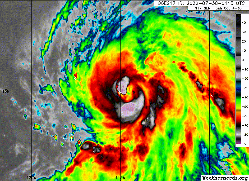
* IR SAT DATA AVAILABLE, OHC AVAILABLE *
* FRANK EP072022 07/30/22 00 UTC *

TIME (HR) 0 6 12 18 24 36 48 60 72 84 96 108 120 132 144 156 168
V (KT) NO LAND 70 79 89 97 102 107 101 87 70 54 42 30 22 N/A N/A N/A N/A
V (KT) LAND 70 79 89 97 102 107 101 87 70 54 42 30 22 N/A N/A N/A N/A
V (KT) LGEM 70 78 86 91 94 93 83 69 56 44 36 30 26 22 19 N/A N/A
Storm Type TROP TROP TROP TROP TROP TROP TROP TROP TROP TROP TROP TROP TROP TROP TROP N/A N/A

SHEAR (KT) 1 6 3 3 4 7 4 4 5 3 2 12 17 20 23 N/A N/A
SHEAR ADJ (KT) -4 -6 -3 0 -1 0 0 -1 0 0 -2 -2 0 -1 0 N/A N/A
SHEAR DIR 18 24 8 352 44 76 56 304 313 341 239 253 261 254 258 N/A N/A
SST (C) 28.6 28.4 28.4 28.1 27.6 26.1 24.9 23.7 22.0 21.6 21.3 21.1 21.1 21.1 21.4 N/A N/A
POT. INT. (KT) 150 149 149 145 140 124 112 99 81 77 73 72 71 71 74 N/A N/A
200 MB T (C) -52.2 -52.6 -52.5 -52.3 -51.6 -52.1 -51.4 -51.7 -51.4 -52.0 -52.1 -52.2 -52.3 -52.2 -52.0 N/A N/A
200 MB VXT (C) 0.3 0.6 0.7 0.7 0.8 0.8 0.8 1.0 0.9 0.9 0.5 0.2 0.7 0.6 1.1 N/A N/A
TH_E DEV (C) 6 6 5 4 3 2 1 0 0 0 0 0 0 0 0 N/A N/A
700-500 MB RH 74 73 72 72 73 71 68 62 61 57 56 58 52 48 39 N/A N/A
MODEL VTX (KT) 27 29 31 32 32 32 32 30 27 23 21 18 17 15 13 LOST LOST
850 MB ENV VOR 33 40 31 36 46 61 82 89 90 73 70 40 24 22 18 N/A N/A
200 MB DIV 128 96 74 72 89 83 31 1 11 0 11 9 8 -4 0 N/A N/A
700-850 TADV -3 -4 -1 0 0 0 0 -2 4 -1 1 2 5 6 4 N/A N/A
LAND (KM) 1012 1002 1005 1017 1025 1029 1068 1085 1118 1184 1254 1287 1276 1296 1357 N/A N/A
LAT (DEG N) 14.8 15.4 16.0 16.6 17.2 18.4 19.7 21.0 22.3 23.3 24.2 25.2 26.3 xx.x xx.x N/A N/A
LONG(DEG W) 114.4 115.3 116.2 117.1 117.9 119.5 121.1 122.7 124.3 125.7 126.9 128.1 129.5 xxx.x xxx.x N/A N/A
STM SPEED (KT) 10 11 11 10 10 10 10 10 9 8 7 8 7 6 6 N/A N/A
HEAT CONTENT 16 13 12 10 6 0 0 0 0 0 0 0 0 0 0 N/A N/A

FORECAST TRACK FROM OFCI INITIAL HEADING/SPEED (DEG/KT):295/ 9 CX,CY: -7/ 4
T-12 MAX WIND: 55 PRESSURE OF STEERING LEVEL (MB): 563 (MEAN=587)
GOES IR BRIGHTNESS TEMP. STD DEV. 50-200 KM RAD: 4.5 (MEAN=14.5)
% GOES IR PIXELS WITH T < -20 C 50-200 KM RAD: 100.0 (MEAN=65.0)
PRELIM RI PROB (DV .GE. 35 KT IN 36 HR): 63.3

INDIVIDUAL CONTRIBUTIONS TO INTENSITY CHANGE
6 12 18 24 36 48 60 72 84 96 108 120 132 144 156 168
------------------------------------------------------------------------------
SAMPLE MEAN CHANGE 0. 0. 1. 1. 1. 2. 1. 1. 0. -0. -1. -2. -2. -3. -4. -4.
SST POTENTIAL 1. 2. 3. 3. 2. -1. -5. -10. -15. -19. -24. -30. -35. -40. -43. -46.
VERTICAL SHEAR MAG 0. 1. 2. 2. 3. 5. 7. 8. 9. 11. 11. 9. 6. 3. 3. 3.
VERTICAL SHEAR ADJ 0. 1. 1. 1. 2. 2. 1. 1. 1. 0. 0. 0. 0. 0. 0. 1.
VERTICAL SHEAR DIR 0. 0. 0. 1. 1. 1. 1. 1. 0. 1. 2. 2. 3. 3. 3. 3.
PERSISTENCE 3. 5. 5. 5. 4. 2. 1. 1. 0. 1. 0. 0. -0. 0. 0. 0.
200/250 MB TEMP. -0. -0. -0. -1. -1. -1. -1. -0. 0. 1. 2. 3. 4. 6. 7. 8.
THETA_E EXCESS -0. -0. -0. -1. -2. -4. -5. -7. -9. -10. -12. -12. -13. -14. -16. -18.
700-500 MB RH 0. 0. 0. 0. 1. 1. 1. 1. 1. 1. 0. 0. 0. 0. 0. 0.
MODEL VTX TENDENCY 1. 2. 4. 4. 4. 5. 3. 1. -5. -8. -12. -12. -12. -13. -12. -11.
850 MB ENV VORTICITY 0. 0. 0. 0. 0. -0. -0. -1. -1. -1. -1. -1. -1. -1. -1. -1.
200 MB DIVERGENCE 0. 1. 1. 1. 1. 2. 2. 2. 1. 1. 0. 0. -0. -0. 0. 0.
850-700 T ADVEC 0. 0. 0. 0. 0. -0. -0. 0. 0. 0. 0. 0. 0. 0. 1. 1.
ZONAL STORM MOTION 0. 0. 0. 0. 0. 0. 0. 0. 0. 0. -0. -0. -0. -0. -0. 0.
STEERING LEVEL PRES -0. -0. -0. -0. -0. -0. -0. -0. -0. -0. -0. -0. -0. -0. -0. -0.
DAYS FROM CLIM. PEAK 0. 0. 0. 0. 0. 0. 0. 0. 0. 0. 0. 0. 0. 0. -0. -0.
GOES PREDICTORS 2. 3. 3. 3. 3. 3. 3. 3. 3. 3. 3. 3. 3. 2. 2. 1.
OCEAN HEAT CONTENT -0. -0. -0. -0. -0. -1. -1. -1. -0. -0. 0. 1. 2. 2. 4. 5.
RI POTENTIAL 2. 4. 8. 12. 18. 17. 10. 2. -2. -6. -9. -11. -11. -11. -10. -10.
------------------------------------------------------------------------------
TOTAL CHANGE 9. 19. 27. 32. 37. 31. 17. 0. -16. -28. -40. -48. -56. -64. -65. -67.

CURRENT MAX WIND (KT): 70. LAT, LON: 14.8 114.4

** 2021 E. Pacific RI INDEX EP072022 FRANK 07/30/22 00 UTC **
(SHIPS-RII PREDICTOR TABLE for 30 KT OR MORE MAXIMUM WIND INCREASE IN NEXT 24-h)

Predictor Value RI Predictor Range Scaled Value(0-1) % Contribution
POT = MPI-VMAX (KT) : 76.6 40.5 to 149.3 0.33 6.4
12 HR PERSISTENCE (KT) : 15.0 -22.0 to 44.0 0.56 12.4
D200 (10**7s-1) : 91.8 -33.0 to 159.5 0.65 11.6
850-200 MB SHEAR (KT) : 3.6 19.6 to 1.3 0.87 15.0
MAXIMUM WIND (KT) : 70.0 22.5 to 132.0 0.83 11.3
STD DEV OF IR BR TEMP : 4.5 37.8 to 2.1 0.93 11.4
BL DRY-AIR FLUX (W/M2) : 201.8 800.8 to -82.5 0.68 -9.2
HEAT CONTENT (KJ/CM2) : 11.4 2.7 to 106.7 0.08 0.9
%area of TPW <45 mm upshear : 0.0 56.6 to 0.0 1.00 3.8
2nd PC OF IR BR TEMP : 0.3 2.2 to -2.3 0.43 0.9

SHIPS Prob RI for 20kt/ 12hr RI threshold= 62% is 9.8 times climatological mean ( 6.3%)
SHIPS Prob RI for 25kt/ 24hr RI threshold= 71% is 5.7 times climatological mean (12.5%)
SHIPS Prob RI for 30kt/ 24hr RI threshold= 65% is 7.5 times climatological mean ( 8.6%)
SHIPS Prob RI for 35kt/ 24hr RI threshold= 57% is 9.2 times climatological mean ( 6.2%)
SHIPS Prob RI for 40kt/ 24hr RI threshold= 50% is 11.9 times climatological mean ( 4.2%)
SHIPS Prob RI for 45kt/ 36hr RI threshold= 36% is 5.3 times climatological mean ( 6.7%)
SHIPS Prob RI for 55kt/ 48hr RI threshold= 16% is 2.7 times climatological mean ( 5.9%)
SHIPS Prob RI for 65kt/ 72hr RI threshold= 0% is 0.0 times climatological mean ( 4.7%)

Matrix of RI probabilities
------------------------------------------------------------------------------
RI (kt / h) | 20/12 | 25/24 | 30/24 | 35/24 | 40/24 | 45/36 | 55/48 |65/72
------------------------------------------------------------------------------
SHIPS-RII: 61.7% 70.7% 64.6% 57.1% 50.0% 35.8% 15.8% 0.0%
Logistic: 65.5% 77.3% 66.7% 65.2% 45.3% 36.9% 2.1% 0.1%
Bayesian: 45.4% 40.0% 39.4% 32.3% 16.6% 1.4% 0.0% 0.0%
Consensus: 57.5% 62.7% 56.9% 51.5% 37.3% 24.7% 6.0% 0.0%
DTOPS: 59.0% 80.0% 63.0% 44.0% 31.0% 43.0% 5.0% 0.0%

## ANNULAR HURRICANE INDEX (AHI) EP072022 FRANK 07/30/22 00 UTC ##
## STORM NOT ANNULAR, SCREENING STEP FAILED, NPASS=5 NFAIL=2 ##
## AHI= 0 (AHI OF 100 IS BEST FIT TO ANN. STRUC., 1 IS MARGINAL, 0 IS NOT ANNULAR) ##
0 likes   

User avatar
cycloneye
Admin
Admin
Posts: 139027
Age: 67
Joined: Thu Oct 10, 2002 10:54 am
Location: San Juan, Puerto Rico

Re: EPAC: FRANK - Hurricane

#102 Postby cycloneye » Fri Jul 29, 2022 9:32 pm

Hurricane Frank Discussion Number 16
NWS National Hurricane Center Miami FL EP072022
900 PM MDT Fri Jul 29 2022

Frank is on a strengthening trend. Satellite images show that deep
convection has become more symmetric around the center, and there
have been hints of an eye forming. Although banding features have
become well established, microwave data indicate that a well-defined
inner has not yet developed. The latest satellite intensity
estimates range from 60 to 77 kt, and based on that data and the
improvement in the system's structure, the initial intensity is
increased to 70 kt. The minimum pressure has been set at 983 mb.
This makes Frank the sixth hurricane of the 2022 eastern North
Pacific season.

Over the past 12 hours, Frank has been moving west-northwestward at
9 kt. A turn to the northwest is expected on Saturday, and that
motion is forecast to continue during the next several days as the
hurricane moves toward a weakness in the subtropical ridge. The NHC
track forecast is a little to the left of the previous one,
partially due to an adjustment of the initial position in that
direction. This forecast lies close to the multi-model consensus
TVCE from 12 to 72 hours, but is left of that aid beyond that,
leaning toward the GFS and ECMWF models.

Frank is expected to remain in near ideal conditions of very low
wind shear, warm waters, and a moist airmass for another 24-36
hours. In fact, the SHIPS Rapid Intensification Indices show a
greater than 60 percent chance that Frank could rapidly intensify
during that period. The NHC intensity forecast during that time has
been adjusted upward and lies a little above the consensus aids
given the favorable environment and improving storm structure.
However, by late Sunday, Frank will be moving over much cooler
waters and into a progressively drier airmass, which should cause
steady weakening. Although the system will be moving over quite cool
waters in a few days, the GFS model suggests that it could still be
producing some deep convection enhanced by a nearby trough, which
might delay its transition into a remnant low.

It again should be noted that Frank and Tropical Storm Georgette
are expected to come close enough to one another for some
interaction. Frank will be the larger and dominant system during
this interaction, and the smaller and weaker Georgette will have
little impact on the track or intensity of Frank.

FORECAST POSITIONS AND MAX WINDS

INIT 30/0300Z 15.1N 114.8W 70 KT 80 MPH
12H 30/1200Z 16.0N 116.2W 80 KT 90 MPH
24H 31/0000Z 17.1N 117.8W 95 KT 110 MPH
36H 31/1200Z 18.5N 119.4W 95 KT 110 MPH
48H 01/0000Z 19.7N 120.8W 85 KT 100 MPH
60H 01/1200Z 21.0N 122.4W 70 KT 80 MPH
72H 02/0000Z 22.2N 123.9W 55 KT 65 MPH
96H 03/0000Z 24.3N 126.8W 35 KT 40 MPH
120H 04/0000Z 26.3N 129.3W 25 KT 30 MPH...POST-TROP/REMNT LOW

$$
Forecaster Cangialosi
0 likes   
Visit the Caribbean-Central America Weather Thread where you can find at first post web cams,radars
and observations from Caribbean basin members Click Here

Sciencerocks
Category 5
Category 5
Posts: 7282
Age: 38
Joined: Thu Jul 06, 2017 1:51 am

Re: EPAC: FRANK - Hurricane

#103 Postby Sciencerocks » Fri Jul 29, 2022 11:37 pm

Image
4 likes   

User avatar
Yellow Evan
Professional-Met
Professional-Met
Posts: 15951
Age: 25
Joined: Fri Jul 15, 2011 12:48 pm
Location: Henderson, Nevada/Honolulu, HI
Contact:

Re: EPAC: FRANK - Hurricane

#104 Postby Yellow Evan » Sat Jul 30, 2022 1:28 am

TXPZ28 KNES 300601
TCSENP

A. 07E (FRANK)

B. 30/0530Z

C. 15.6N

D. 114.9W

E. ONE/GOES-W

F. T5.0/5.0

G. IR/EIR/SWIR/SSMIS

H. REMARKS...MG EYE SURROUNDED BY B AND EMBEDDED IN LG RESULTS IN A DT
OF 5.0. MET AND PT ARE ALSO 5.0. THE FT IS BASED ON THE DT.

I. ADDL POSITIONS

30/0219Z 15.1N 114.4W SSMIS


...CLARK
0 likes   

User avatar
cycloneye
Admin
Admin
Posts: 139027
Age: 67
Joined: Thu Oct 10, 2002 10:54 am
Location: San Juan, Puerto Rico

Re: EPAC: FRANK - Hurricane

#105 Postby cycloneye » Sat Jul 30, 2022 4:52 am

Hurricane Frank Discussion Number 17
NWS National Hurricane Center Miami FL EP072022
200 AM PDT Sat Jul 30 2022

Frank has continued to intensify since the previous advisory, with
very cold cloud tops noted over the eastern and southern portions
of the circulation. An eye has been occasionally present in the
geostationary images. Subjective Dvorak intensity estimates from
SAB and TAFB are 90 kt and 77 kt respectively, and the advisory
intensity is set at 80 kt. Frank has an expansive, well-defined
upper-level outflow pattern.

Microwave images suggest that the hurricane is beginning to
establish a better-defined inner core. This indicates that rapid
intensification (RI) is possible today. The various objective
indices show a 40 to 50 percent chance of RI during the next 12-24
h. Thus Frank could become a major hurricane soon and this is
reflected in the latest NHC forecast. Frank's strengthening is
likely to be rather short-lived however, since the hurricane will
be traversing significantly cooler waters within 48 hours. By 96
hours, the cyclone should be over 21 deg C SSTs so the forecast
shows Frank degenerating into a remnant low by that time. Around
the end of the forecast period, the GFS model shows some
rejuvenation of convection as the post-tropical cyclone interacts
with an upper-level trough to its northwest.

The hurricane is moving northwestward, or 310/10 kt. The steering
scenario appears to be fairly straightforward. Frank should
continue on a northwestward track for most of the forecast period
while it moves along the southwestern periphery of a large
mid-level ridge. The official track forecast has been nudged
a little to the north of the previous one mainly because of a
slight northward shift in the short-term track.


FORECAST POSITIONS AND MAX WINDS

INIT 30/0900Z 15.9N 115.4W 80 KT 90 MPH
12H 30/1800Z 16.9N 116.6W 90 KT 105 MPH
24H 31/0600Z 18.2N 118.2W 100 KT 115 MPH
36H 31/1800Z 19.5N 119.6W 90 KT 105 MPH
48H 01/0600Z 20.9N 121.1W 75 KT 85 MPH
60H 01/1800Z 22.3N 122.6W 60 KT 70 MPH
72H 02/0600Z 23.4N 124.0W 45 KT 50 MPH
96H 03/0600Z 25.5N 126.7W 30 KT 35 MPH...POST-TROP/REMNT LOW
120H 04/0600Z 28.0N 128.5W 25 KT 30 MPH...POST-TROP/REMNT LOW

$$
Forecaster Pasch
0 likes   
Visit the Caribbean-Central America Weather Thread where you can find at first post web cams,radars
and observations from Caribbean basin members Click Here

User avatar
cycloneye
Admin
Admin
Posts: 139027
Age: 67
Joined: Thu Oct 10, 2002 10:54 am
Location: San Juan, Puerto Rico

Re: EPAC: FRANK - Hurricane

#106 Postby cycloneye » Sat Jul 30, 2022 7:52 am

EP, 07, 2022073012, , BEST, 0, 162N, 1158W, 80, 975, HU
0 likes   
Visit the Caribbean-Central America Weather Thread where you can find at first post web cams,radars
and observations from Caribbean basin members Click Here

User avatar
Kingarabian
S2K Supporter
S2K Supporter
Posts: 15433
Joined: Sat Aug 08, 2009 3:06 am
Location: Honolulu, Hawaii

Re: EPAC: FRANK - Hurricane

#107 Postby Kingarabian » Sat Jul 30, 2022 8:47 am

It's quickly losing its sprawling banding features. Also seems to be getting smaller in size. Might help it, but it is really struggling with dry air.
0 likes   
RIP Kobe Bryant

Sciencerocks
Category 5
Category 5
Posts: 7282
Age: 38
Joined: Thu Jul 06, 2017 1:51 am

Re: EPAC: FRANK - Hurricane

#108 Postby Sciencerocks » Sat Jul 30, 2022 9:11 am

Image
1 likes   

Ntxw
Storm2k Moderator
Storm2k Moderator
Posts: 21495
Joined: Wed Oct 21, 2009 6:34 pm
Location: DFW, Texas

Re: EPAC: FRANK - Hurricane

#109 Postby Ntxw » Sat Jul 30, 2022 9:33 am

Couldn't work out dry air, likely has already peaked.
1 likes   
The above post and any post by Ntxw is NOT an official forecast and should not be used as such. It is just the opinion of the poster and may or may not be backed by sound meteorological data. It is NOT endorsed by any professional institution including Storm2k. For official information, please refer to NWS products.

  Help support Storm2K!
Help Support Storm2K

User avatar
cycloneye
Admin
Admin
Posts: 139027
Age: 67
Joined: Thu Oct 10, 2002 10:54 am
Location: San Juan, Puerto Rico

Re: EPAC: FRANK - Hurricane

#110 Postby cycloneye » Sat Jul 30, 2022 9:43 am

Hurricane Frank Discussion Number 18
NWS National Hurricane Center Miami FL EP072022
800 AM PDT Sat Jul 30 2022

Frank has changed little in organization since the last advisory.
The hurricane continues to produce bands of cold deep convection
near the center, but an eye is not currently apparent. Since the
various satellite intensity estimates are also basically unchanged,
the initial intensity remains set at 80 kt. The hurricane
continues to have excellent cirrus outflow in all directions
except the southwest.

Frank is running out of time to intensify, as it is now passing
over the 28C sea surface temperature isotherm and will reach waters
of 26C in about 24 h. The guidance indicates that some
strengthening is possible during the next 12 h, although the chances
of rapid intensification have diminished. Thus, the intensity
forecast now calls for a 90-kt peak intensity in 12 h, which is at
the upper edge of the guidance. After 24 h, the cyclone should
move over progressively cooler water, reaching 21C SSTs in about
96 h. This should lead to a steady weakening, and Frank is
expected to degenerate to a remnant low by 96 h. It should be noted
that near the end of the forecast period, the GFS model shows some
rejuvenation of convection as the post-tropical cyclone interacts
with an upper-level trough to its northwest.

Frank continues moving northwestward or 310/10 kt, and there is
little change to the track forecast scenario. The cyclone should
continue on a northwestward track for most of the forecast period
while it moves along the southwestern periphery of a large
mid-level ridge toward a developing break in the ridge west of
California. The track guidance shifted a little to the north and
east at 96 and 120 h, and thus the new forecast track is also
nudged in that direction at those times. Otherwise, it is an
update of the previous forecast and lies close to the consensus
models.


FORECAST POSITIONS AND MAX WINDS

INIT 30/1500Z 16.6N 116.3W 80 KT 90 MPH
12H 31/0000Z 17.6N 117.4W 90 KT 105 MPH
24H 31/1200Z 18.9N 119.0W 85 KT 100 MPH
36H 01/0000Z 20.1N 120.4W 75 KT 85 MPH
48H 01/1200Z 21.4N 121.9W 60 KT 70 MPH
60H 02/0000Z 22.7N 123.3W 50 KT 60 MPH
72H 02/1200Z 24.0N 124.7W 40 KT 45 MPH
96H 03/1200Z 26.6N 127.0W 30 KT 35 MPH...POST-TROP/REMNT LOW
120H 04/1200Z 28.6N 128.0W 25 KT 30 MPH...POST-TROP/REMNT LOW

$$
Forecaster Beven
0 likes   
Visit the Caribbean-Central America Weather Thread where you can find at first post web cams,radars
and observations from Caribbean basin members Click Here

User avatar
Yellow Evan
Professional-Met
Professional-Met
Posts: 15951
Age: 25
Joined: Fri Jul 15, 2011 12:48 pm
Location: Henderson, Nevada/Honolulu, HI
Contact:

Re: EPAC: FRANK - Hurricane

#111 Postby Yellow Evan » Sat Jul 30, 2022 10:46 am

Image

This is super fragile and will be until thicker convection wraps around. I’d be confident in Category 4 if Frank had another 48-60 hours but this is not the case here.
0 likes   

User avatar
ElectricStorm
Category 5
Category 5
Posts: 4524
Age: 23
Joined: Tue Aug 13, 2019 11:23 pm
Location: Skiatook, OK / Norman, OK

Re: EPAC: FRANK - Hurricane

#112 Postby ElectricStorm » Sat Jul 30, 2022 1:48 pm

Looks like it's recovered from the dry air issues from earlier. Should see another round of intensification here over the next several hours.
0 likes   
I am in no way a professional. Take what I say with a grain of salt as I could be totally wrong. Please refer to the NHC, NWS, or SPC for official information.

Boomer Sooner!

User avatar
cycloneye
Admin
Admin
Posts: 139027
Age: 67
Joined: Thu Oct 10, 2002 10:54 am
Location: San Juan, Puerto Rico

Re: EPAC: FRANK - Hurricane

#113 Postby cycloneye » Sat Jul 30, 2022 4:02 pm

Hurricane Frank Discussion Number 19
NWS National Hurricane Center Miami FL EP072022
200 PM PDT Sat Jul 30 2022

Frank's convective pattern is currently comprised of an inner area
of eyewall convection that is now almost surrounded by outer
convective bands. However, an eye has not appeared since the last
advisory, and the inner core convection is a bit sporadic and
asymmetric. The various satellite intensity estimates are again
unchanged since the last advisory, so the initial intensity remains
at 80 kt.

The hurricane is now moving over decreasing sea surface
temperatures and it has just about run out of time to intensify.
The center should reach the 26C isotherm in 12-18 h and reach 21C
water by 72 h. This should cause steady to rapid weakening to occur
after 12 h, with Frank forecast to decay to a remnant low by 96 h.
The new intensity forecast is adjusted downward from the previous
advisory and it follows the trend of the intensity guidance. It
should be noted that near the end of the forecast period, the GFS
model continues to show some rejuvenation of convection as the
post-tropical cyclone interacts with an upper-level trough to its
northwest.

Frank continues moving northwestward or 310/10 kt, and there is
again little change to the track forecast scenario. The cyclone
should continue on a northwestward track for most of the forecast
period while it moves along the southwestern periphery of a large
mid-level ridge toward a developing break in the ridge west of
California. The track guidance has made yet another slight shift to
the north and east at 96 and 120 h, and the latest forecast shows a
similar slight shift at those times. Otherwise, it is another
update of the previous forecast that lies close to the consensus
models.


FORECAST POSITIONS AND MAX WINDS

INIT 30/2100Z 17.2N 117.1W 80 KT 90 MPH
12H 31/0600Z 18.1N 118.2W 80 KT 90 MPH
24H 31/1800Z 19.5N 119.8W 75 KT 85 MPH
36H 01/0600Z 20.8N 121.3W 65 KT 75 MPH
48H 01/1800Z 22.1N 122.7W 55 KT 65 MPH
60H 02/0600Z 23.5N 124.1W 45 KT 50 MPH
72H 02/1800Z 24.9N 125.4W 35 KT 40 MPH
96H 03/1800Z 27.5N 127.0W 25 KT 30 MPH...POST-TROP/REMNT LOW
120H 04/1800Z 29.0N 127.5W 25 KT 30 MPH...POST-TROP/REMNT LOW

$$
Forecaster Beven
0 likes   
Visit the Caribbean-Central America Weather Thread where you can find at first post web cams,radars
and observations from Caribbean basin members Click Here

User avatar
ElectricStorm
Category 5
Category 5
Posts: 4524
Age: 23
Joined: Tue Aug 13, 2019 11:23 pm
Location: Skiatook, OK / Norman, OK

Re: EPAC: FRANK - Hurricane

#114 Postby ElectricStorm » Sat Jul 30, 2022 4:14 pm

ElectricStorm wrote:Looks like it's recovered from the dry air issues from earlier. Should see another round of intensification here over the next several hours.

Welp looks like more dry air got in
0 likes   
I am in no way a professional. Take what I say with a grain of salt as I could be totally wrong. Please refer to the NHC, NWS, or SPC for official information.

Boomer Sooner!

User avatar
aspen
Category 5
Category 5
Posts: 8056
Joined: Sat Oct 12, 2019 7:10 pm
Location: Connecticut, USA

Re: EPAC: FRANK - Hurricane

#115 Postby aspen » Sat Jul 30, 2022 5:29 pm

ElectricStorm wrote:
ElectricStorm wrote:Looks like it's recovered from the dry air issues from earlier. Should see another round of intensification here over the next several hours.

Welp looks like more dry air got in

A perfect summary of (most) La Niña EPac storms.
2 likes   
Irene '11 Sandy '12 Hermine '16 5/15/2018 Derecho Fay '20 Isaias '20 Elsa '21 Henri '21 Ida '21

I am only a meteorology enthusiast who knows a decent amount about tropical cyclones. Look to the professional mets, the NHC, or your local weather office for the best information.

User avatar
cycloneye
Admin
Admin
Posts: 139027
Age: 67
Joined: Thu Oct 10, 2002 10:54 am
Location: San Juan, Puerto Rico

Re: EPAC: FRANK - Hurricane

#116 Postby cycloneye » Sat Jul 30, 2022 5:43 pm

aspen wrote:
ElectricStorm wrote:
ElectricStorm wrote:Looks like it's recovered from the dry air issues from earlier. Should see another round of intensification here over the next several hours.

Welp looks like more dry air got in

A perfect summary of (most) La Niña EPac storms.


Same happened with Estelle. La Niña syndrome kicking in.
0 likes   
Visit the Caribbean-Central America Weather Thread where you can find at first post web cams,radars
and observations from Caribbean basin members Click Here

User avatar
Yellow Evan
Professional-Met
Professional-Met
Posts: 15951
Age: 25
Joined: Fri Jul 15, 2011 12:48 pm
Location: Henderson, Nevada/Honolulu, HI
Contact:

Re: EPAC: FRANK - Hurricane

#117 Postby Yellow Evan » Sat Jul 30, 2022 5:56 pm

“La Nina syndrome” is an oversimplification as atmospheric conditions that naturally vary from TC to TC anyway. The ENSO state just influences the chances of an EPAC TC encountering higher shear but I’m not sure fully it explains Frank in particular because it’s problem was mostly dry air.
3 likes   

User avatar
Yellow Evan
Professional-Met
Professional-Met
Posts: 15951
Age: 25
Joined: Fri Jul 15, 2011 12:48 pm
Location: Henderson, Nevada/Honolulu, HI
Contact:

Re: EPAC: FRANK - Hurricane

#118 Postby Yellow Evan » Sat Jul 30, 2022 6:05 pm

0 likes   

User avatar
aspen
Category 5
Category 5
Posts: 8056
Joined: Sat Oct 12, 2019 7:10 pm
Location: Connecticut, USA

Re: EPAC: FRANK - Hurricane

#119 Postby aspen » Sat Jul 30, 2022 8:13 pm


The HWRF was showing a situation just like this, with dry air sneaking into the system while undergoing an EWRC with a massive outer eyewall.
0 likes   
Irene '11 Sandy '12 Hermine '16 5/15/2018 Derecho Fay '20 Isaias '20 Elsa '21 Henri '21 Ida '21

I am only a meteorology enthusiast who knows a decent amount about tropical cyclones. Look to the professional mets, the NHC, or your local weather office for the best information.

User avatar
cycloneye
Admin
Admin
Posts: 139027
Age: 67
Joined: Thu Oct 10, 2002 10:54 am
Location: San Juan, Puerto Rico

Re: EPAC: FRANK - Hurricane

#120 Postby cycloneye » Sat Jul 30, 2022 9:37 pm

Hurricane Frank Discussion Number 20
NWS National Hurricane Center Miami FL EP072022
800 PM PDT Sat Jul 30 2022

Satellite images indicate that Frank appears to have reached a
generally steady state. Although the convective banding remains well
established on the south and east sides, there are pronounced dry
slots on the system's west side. In addition, the ragged eye feature
seen occasionally earlier today is no longer evident. There is a
large spread in the satellite intensity estimates this evening with
the University of Wisconsin ADT on the low side at 63 kt and
subjective estimates as high as 90 kt. The initial intensity is held
at 80 kt based on a blend of that data.

Frank is just about out of time to strengthen as it is nearing the
26 degree C SST isotherm. The hurricane is expected to track over
increasingly cooler waters during the next few days and move into a
progressively drier and more stable environment. These factors
should cause a steady weakening trend, and Frank is now expected to
become a post-tropical cyclone by 72 hours. This forecast lies a
little above the latest IVCN and HCCA consensus models.

Frank has been moving steadily to the northwest, with the latest
initial motion estimated to be 315/10 kt. This general motion is
expected to continue as the hurricane moves toward a weakness in the
subtropical ridge caused by a large mid- to upper-level low off the
California coast. When Frank becomes a shallow and weak remnant low
in a few days, it will likely slow down and turn toward the north in
the low-level flow. The new NHC track forecast is a little faster
and slightly to the right of the previous one, trending toward the
latest consensus models.


FORECAST POSITIONS AND MAX WINDS

INIT 31/0300Z 18.0N 117.7W 80 KT 90 MPH
12H 31/1200Z 19.0N 118.8W 75 KT 85 MPH
24H 01/0000Z 20.4N 120.3W 70 KT 80 MPH
36H 01/1200Z 21.7N 121.7W 60 KT 70 MPH
48H 02/0000Z 23.2N 123.2W 50 KT 60 MPH
60H 02/1200Z 24.7N 124.5W 40 KT 45 MPH
72H 03/0000Z 26.3N 125.8W 35 KT 40 MPH...POST-TROPICAL
96H 04/0000Z 28.8N 126.5W 25 KT 30 MPH...POST-TROP/REMNT LOW
120H 05/0000Z 31.2N 126.3W 20 KT 25 MPH...POST-TROP/REMNT LOW

$$
Forecaster Cangialosi
0 likes   
Visit the Caribbean-Central America Weather Thread where you can find at first post web cams,radars
and observations from Caribbean basin members Click Here


Return to “2022”

Who is online

Users browsing this forum: No registered users and 38 guests