EPAC: GEORGETTE - Post-Tropical

Moderator: S2k Moderators

Message
Author
User avatar
cycloneye
Admin
Admin
Posts: 139019
Age: 67
Joined: Thu Oct 10, 2002 10:54 am
Location: San Juan, Puerto Rico

Re: EPAC: GEORGETTE - Tropical Depression

#61 Postby cycloneye » Mon Aug 01, 2022 4:35 am

Tropical Depression Georgette Discussion Number 20
NWS National Hurricane Center Miami FL EP082022
200 AM PDT Mon Aug 01 2022

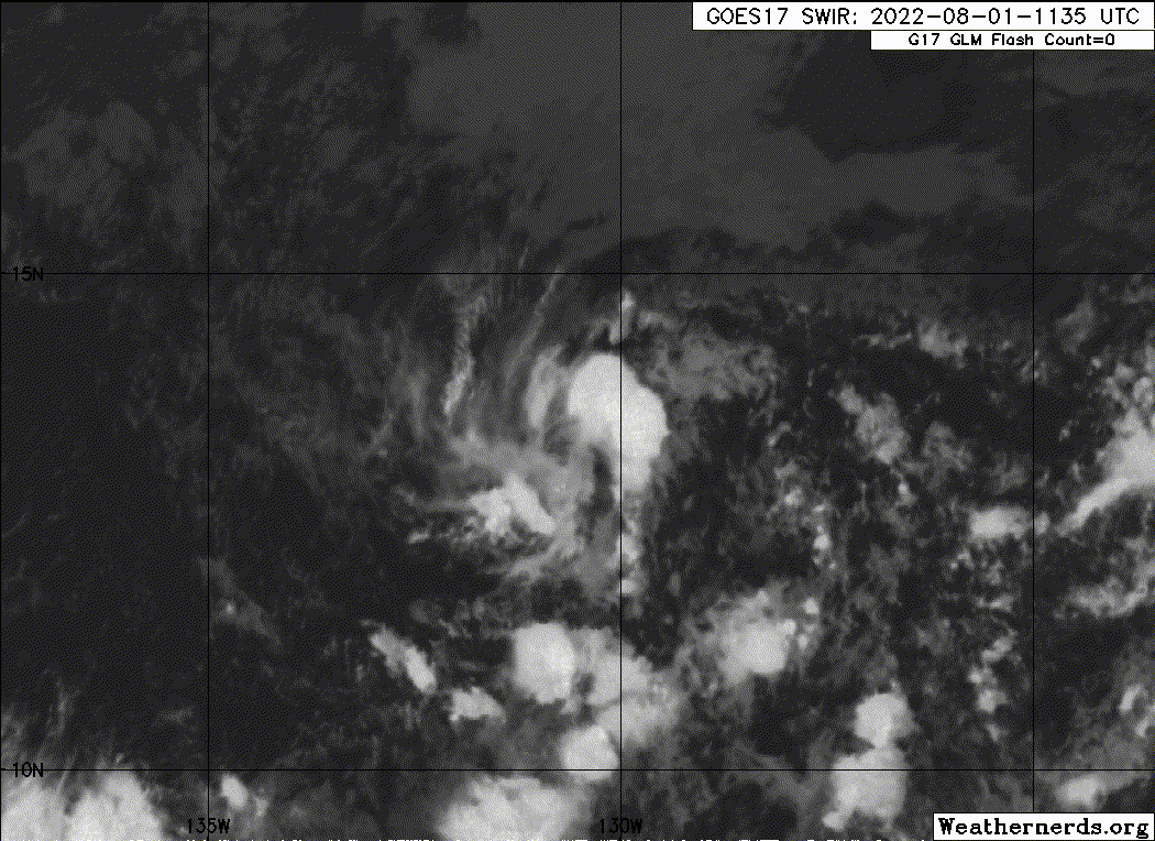
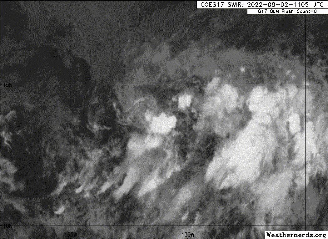
Deep convection has increased again near and to the west and
southwest of the center of the tropical cyclone. This is likely a
diurnal fluctuation, and the convection is not very well organized.
The advisory intensity is held at 30 kt, which is the average of
Dvorak estimates from SAB and TAFB.

The depression has been drifting a little north of west with a
current motion estimate of just 280/2 kt. Georgette is expected to
turn northward or north-northeastward into a weakness in the
subtropical ridge during the next couple of days. Later in the
forecast period, the ridge is likely to build to the north of the
cyclone which should induce a turn toward the west. The official
forecast track is shifted a little eastward from the previous NHC
prediction, toward the latest multi-model consensus guidance.
However, there is a lot of spread in the model tracks, so the
official forecast is of relatively low confidence.

Over the next several days, Georgette should remain in an
environment of moderate east-northeasterly vertical shear and
within a relatively dry low- to mid-level air mass. These
conditions are expected to prevent restrengthening of the cyclone
and cause degeneration into a remnant low in the latter part of the
forecast period. The official intensity forecast is the same as the
previous one and lies between the latest LGEM and DSHIPS guidance
models.


FORECAST POSITIONS AND MAX WINDS

INIT 01/0900Z 12.8N 130.2W 30 KT 35 MPH
12H 01/1800Z 13.2N 130.1W 30 KT 35 MPH
24H 02/0600Z 13.8N 130.0W 30 KT 35 MPH
36H 02/1800Z 14.6N 129.7W 30 KT 35 MPH
48H 03/0600Z 15.4N 129.4W 30 KT 35 MPH
60H 03/1800Z 16.0N 129.5W 30 KT 35 MPH
72H 04/0600Z 16.5N 130.3W 30 KT 35 MPH
96H 05/0600Z 16.5N 133.0W 25 KT 30 MPH...POST-TROP/REMNT LOW
120H 06/0600Z 15.4N 137.0W 25 KT 30 MPH...POST-TROP/REMNT LOW

$$
Forecaster Pasch
0 likes   
Visit the Caribbean-Central America Weather Thread where you can find at first post web cams,radars
and observations from Caribbean basin members Click Here

User avatar
cycloneye
Admin
Admin
Posts: 139019
Age: 67
Joined: Thu Oct 10, 2002 10:54 am
Location: San Juan, Puerto Rico

Re: EPAC: GEORGETTE - Tropical Depression

#62 Postby cycloneye » Mon Aug 01, 2022 9:41 am

Tropical Depression Georgette Discussion Number 21
NWS National Hurricane Center Miami FL EP082022
800 AM PDT Mon Aug 01 2022

Georgette continues to be characterized by pulsating and somewhat
disorganized deep convection near it's center of circulation. The
latest Dvorak intensity estimates range from T-1.0 to T-2.5, and a
blend of these values suggests that the initial intensity remains 30
kt.

Satellite imagery indicates that the depression is beginning its
turn toward a weakness in the subtropical ridge, and the current
motion is north-northwest at 3 kt. A turn to the north-northeast is
expected by tonight, and that motion should continue for a couple of
days. The ridge is forecast to strengthen by late this week, which
should cause Georgette to turn westward along with an increase in
forward speed. Overall, the track model guidance has become a
little more clustered than previous cycles, and there has been a
slight shift to the right in the guidance through 72 h. Therefore,
the latest NHC track forecast was adjusted a little right of the
previous one through that time period, but remains a little to the
left of the consensus.

Over the next several days, Georgette should remain in an
environment of moderate east-northeasterly vertical shear and within
a relatively dry low- to mid-level air mass. By 60 h, the cyclone
should move over waters of 25-26 degrees C. These conditions are
expected to prevent restrengthening of the cyclone and cause it to
degenerate into a remnant low toward the latter part of the week.
The official intensity forecast is unchanged from the previous one
and is in good agreement with most of the intensity guidance.


FORECAST POSITIONS AND MAX WINDS

INIT 01/1500Z 13.4N 130.4W 30 KT 35 MPH
12H 02/0000Z 13.8N 130.4W 30 KT 35 MPH
24H 02/1200Z 14.5N 129.9W 30 KT 35 MPH
36H 03/0000Z 15.4N 129.5W 30 KT 35 MPH
48H 03/1200Z 16.4N 129.4W 30 KT 35 MPH
60H 04/0000Z 17.1N 129.7W 30 KT 35 MPH
72H 04/1200Z 17.3N 131.0W 30 KT 35 MPH
96H 05/1200Z 16.6N 134.6W 25 KT 30 MPH...POST-TROP/REMNT LOW
120H 06/1200Z 15.8N 139.0W 25 KT 30 MPH...POST-TROP/REMNT LOW

$$
Forecaster Latto
0 likes   
Visit the Caribbean-Central America Weather Thread where you can find at first post web cams,radars
and observations from Caribbean basin members Click Here

Sciencerocks
Category 5
Category 5
Posts: 7282
Age: 38
Joined: Thu Jul 06, 2017 1:51 am

Re: EPAC: GEORGETTE - Tropical Depression

#63 Postby Sciencerocks » Mon Aug 01, 2022 10:01 am

Image
0 likes   

User avatar
cycloneye
Admin
Admin
Posts: 139019
Age: 67
Joined: Thu Oct 10, 2002 10:54 am
Location: San Juan, Puerto Rico

Re: EPAC: GEORGETTE - Tropical Depression

#64 Postby cycloneye » Mon Aug 01, 2022 3:41 pm

Tropical Depression Georgette Discussion Number 22
NWS National Hurricane Center Miami FL EP082022
200 PM PDT Mon Aug 01 2022

Georgette is a poorly organized tropical depression. Visible
satellite imagery is revealing that the low-level circulation
is not well-defined, and deep convection continues to sputter.
Unfortunately, there is no new satellite wind data over the system
this afternoon to provide a better assessment of the low-level wind
field of the depression. The initial intensity is being kept at 30
kt based on the latest Dvorak intensity estimate from TAFB.
However, this may be generous.

The depression has been drifting north-northwest at about 4 kt today
toward a weakness in the subtropical ridge. A slow
north-northeastward motion is expected to begin tonight and this
motion should continue through Tuesday night. The ridge is forecast
to strengthen by Thursday, which should cause Georgette to turn
westward along with an increase in forward speed. Models are in
generally good agreement on this scenario, and only minor tweaks
were made to the NHC track forecast for this advisory.

Moderate east-northeasterly shear and a dry airmass should prevent
Georgette from strengthening for the next several days. In a couple
of days the cyclone is expected to move over cooler waters and
encounter a more stable airmass. The combination of these factors
should cause Georgette to degenerate into a remnant low. However,
there is a possibility that the system could dissipate before that
time. There was no change to the NHC intensity forecast from the
previous one.

FORECAST POSITIONS AND MAX WINDS

INIT 01/2100Z 13.5N 130.9W 30 KT 35 MPH
12H 02/0600Z 14.0N 130.7W 30 KT 35 MPH
24H 02/1800Z 14.8N 130.1W 30 KT 35 MPH
36H 03/0600Z 15.8N 129.8W 30 KT 35 MPH
48H 03/1800Z 16.7N 130.0W 30 KT 35 MPH
60H 04/0600Z 17.1N 130.8W 30 KT 35 MPH
72H 04/1800Z 17.0N 131.9W 30 KT 35 MPH...POST-TROP/REMNT LOW
96H 05/1800Z 16.2N 136.0W 25 KT 30 MPH...POST-TROP/REMNT LOW
120H 06/1800Z...DISSIPATED

$$
Forecaster Latto
0 likes   
Visit the Caribbean-Central America Weather Thread where you can find at first post web cams,radars
and observations from Caribbean basin members Click Here

User avatar
cycloneye
Admin
Admin
Posts: 139019
Age: 67
Joined: Thu Oct 10, 2002 10:54 am
Location: San Juan, Puerto Rico

Re: EPAC: GEORGETTE - Tropical Depression

#65 Postby cycloneye » Mon Aug 01, 2022 9:42 pm

Tropical Depression Georgette Discussion Number 23
NWS National Hurricane Center Miami FL EP082022
800 PM PDT Mon Aug 01 2022

Small bursts of convection continue to develop near the exposed
low-level center of Georgette this evening. Subjective and
objective satellite intensity estimates from TAFB and UW-CIMSS still
estimate winds of 30-33 kt in this system, and the initial
intensity estimate is held at 30 kt for this advisory. Global
models predict the moderate northeasterly to east-northeasterly
vertical wind shear should persist over Georgette for the next few
days. This and the relatively dry environment around the depression
should prevent any future restrengthening. The NHC intensity
forecast still predicts Georgette to become a post-tropical cyclone
in a few days, however given the poor organization of the
convection, this could happen sooner.

Georgette has been meandering west-northwestward at 4 kt. The
system is expected to turn north-northeastward overnight into a
weakness in the subtropical ridge located to the north of the
cyclone. In about two days, the ridge is expected to build back in
and turn Georgette to the west with an increase in forward speed.
The official track forecast is shifted slightly west of the previous
advisory prediction, mostly due to the westward shift in the initial
position.


FORECAST POSITIONS AND MAX WINDS

INIT 02/0300Z 13.5N 131.2W 30 KT 35 MPH
12H 02/1200Z 14.1N 130.9W 30 KT 35 MPH
24H 03/0000Z 15.0N 130.4W 30 KT 35 MPH
36H 03/1200Z 16.0N 130.3W 30 KT 35 MPH
48H 04/0000Z 16.8N 130.7W 30 KT 35 MPH
60H 04/1200Z 17.1N 131.6W 30 KT 35 MPH
72H 05/0000Z 17.0N 133.2W 30 KT 35 MPH...POST-TROP/REMNT LOW
96H 06/0000Z 16.3N 137.6W 25 KT 30 MPH...POST-TROP/REMNT LOW
120H 07/0000Z...DISSIPATED

$$
Forecaster Bucci/Berg
0 likes   
Visit the Caribbean-Central America Weather Thread where you can find at first post web cams,radars
and observations from Caribbean basin members Click Here

User avatar
cycloneye
Admin
Admin
Posts: 139019
Age: 67
Joined: Thu Oct 10, 2002 10:54 am
Location: San Juan, Puerto Rico

Re: EPAC: GEORGETTE - Tropical Depression

#66 Postby cycloneye » Tue Aug 02, 2022 4:32 am

Tropical Depression Georgette Discussion Number 24
NWS National Hurricane Center Miami FL EP082022
200 AM PDT Tue Aug 02 2022

Like the last couple of nights, Georgette is exhibiting a bursting
pattern this morning, with just enough convective activity to
maintain writing advisories on the tropical cyclone. With that said,
the convection is waning, lacks much organization, and the low-level
center appears to now be exposed to the northeast of the coldest
cloud tops, as indicated by a recently arriving ASCAT-C pass.
Satellite intensity estimates have not changed much despite this
convection, and the peak winds from the scatterometer data was only
26 kt. The initial intensity will remain 30 kt this advisory.

Georgette appears to be making the long-awaited turn to the
north-northeast, with the latest motion estimated at 030/4 kt. This
motion is due to the presence of low- to mid-level southwesterly
flow south of Frank, which is influencing Georgette's steering.
However, after the next 24-48 hours, a low-level ridge is expected
to build back in after Frank departs to the north. The track
guidance responds to this changing synoptic pattern by making
Georgette take a sharp turn westward and then west-southwestward by
the end of the forecast period. The latest track forecast was
shifted a little east of the prior one, but not as far east as the
multi-model consensus aids.

It is unclear how long Georgette will be able to survive the current
marginal environment of moderate (15-20 kt) northeasterly vertical
wind shear and dry (55-60 percent) mid-level relative humidity. Even
sea-surface temperatures gradually cool along its track, from 27 C
currently to below 26 C in 48 hours. Afterwards, both GFS and ECMWF
model simulated IR images suggest the remaining convection with
Georgette will dissipate, and the system is forecast to become a
remnant low by Thursday afternoon. While little change in strength
is shown in the NHC forecast over the next couple of days, it
would not be surprising if the cyclone becomes a remnant low or
loses its well-defined circulation sooner than indicated here.


FORECAST POSITIONS AND MAX WINDS

INIT 02/0900Z 13.7N 130.9W 30 KT 35 MPH
12H 02/1800Z 14.4N 130.5W 30 KT 35 MPH
24H 03/0600Z 15.4N 130.0W 30 KT 35 MPH
36H 03/1800Z 16.2N 130.0W 30 KT 35 MPH
48H 04/0600Z 16.7N 131.0W 30 KT 35 MPH
60H 04/1800Z 16.6N 132.6W 25 KT 30 MPH...POST-TROP/REMNT LOW
72H 05/0600Z 16.1N 134.4W 25 KT 30 MPH...POST-TROP/REMNT LOW
96H 06/0600Z...DISSIPATED

$$
Forecaster Papin
0 likes   
Visit the Caribbean-Central America Weather Thread where you can find at first post web cams,radars
and observations from Caribbean basin members Click Here

Sciencerocks
Category 5
Category 5
Posts: 7282
Age: 38
Joined: Thu Jul 06, 2017 1:51 am

Re: EPAC: GEORGETTE - Tropical Depression

#67 Postby Sciencerocks » Tue Aug 02, 2022 9:31 am

Image
0 likes   

User avatar
cycloneye
Admin
Admin
Posts: 139019
Age: 67
Joined: Thu Oct 10, 2002 10:54 am
Location: San Juan, Puerto Rico

Re: EPAC: GEORGETTE - Tropical Depression

#68 Postby cycloneye » Tue Aug 02, 2022 10:03 am

Tropical Depression Georgette Discussion Number 25
NWS National Hurricane Center Miami FL EP082022
800 AM PDT Tue Aug 02 2022

Convection has continued to pulse near Georgette's circulation
over the past 12 to 24 hours, but there has been little, if any,
organization to the thunderstorm activity during that time. In
fact, the Satellite Analysis Branch (SAB) provided its last
Dvorak T1.0 on the system at 1800 UTC yesterday, indicating the
lack of organization since that time. The initial intensity is set
at a possibly generous 30 kt, which is based on earlier ASCAT data
that showed peak winds just above 25 kt.

Given the lack of organization it now appears more likely that
Georgette will succumb to the marginal environment that is embedded
within. Moderate northeasterly shear, SSTs cooling to around 26C
along the forecast track, and dry mid-level humidity is expected
to result in additional weakening and degeneration of the system to
a remnant low within the next day or two. This could occur as soon
as later today, if organized deep convection does not return.

Georgette has made its much anticipated northeastward turn, with the
latest motion estimated at 040/6 kt. Low- to mid-level
southwesterly flow to the south of Frank should continue to steer
Georgette northeastward during the next 12 to 24 hours. After that
time, a low-level ridge is forecast to build to the north of the
cyclone, which will cause Georgette to turn back sharply westward.
The latest NHC track forecast has been adjusted slightly east of the
previous forecast to be in better agreement with the latest track
model envelope.


FORECAST POSITIONS AND MAX WINDS

INIT 02/1500Z 14.1N 130.4W 30 KT 35 MPH
12H 03/0000Z 14.8N 129.9W 30 KT 35 MPH
24H 03/1200Z 15.7N 129.6W 25 KT 30 MPH
36H 04/0000Z 16.5N 129.8W 25 KT 30 MPH...POST-TROP/REMNT LOW
48H 04/1200Z 16.8N 131.0W 25 KT 30 MPH...POST-TROP/REMNT LOW
60H 05/0000Z 16.7N 132.8W 25 KT 30 MPH...POST-TROP/REMNT LOW
72H 05/1200Z...DISSIPATED

$$
Forecaster Brown
0 likes   
Visit the Caribbean-Central America Weather Thread where you can find at first post web cams,radars
and observations from Caribbean basin members Click Here

User avatar
cycloneye
Admin
Admin
Posts: 139019
Age: 67
Joined: Thu Oct 10, 2002 10:54 am
Location: San Juan, Puerto Rico

Re: EPAC: GEORGETTE - Tropical Depression

#69 Postby cycloneye » Tue Aug 02, 2022 3:49 pm

Tropical Depression Georgette Discussion Number 26
NWS National Hurricane Center Miami FL EP082022
200 PM PDT Tue Aug 02 2022

Convection associated with Georgette became slightly better
organized after the release of the previous advisory, and although
the cloud tops have since warmed, there is a loose band of
thunderstorms around the southwestern portion of the circulation.
Georgette's circulation is still well defined in recent ASCAT data,
therefore the system is likely to remain a tropical cyclone for a
bit longer. Peak wind retrievals from the ASCAT-B instrument were
27-28 kt so the initial intensity remains 30 kt for this advisory.

Despite the recent slight improvement in organization, the overall
intensity forecast reasoning remains unchanged. A marginal
environment characterized by moderate northeasterly shear, SSTs of
26-27C, and mid-level humidity of 55-60 percent are likely to result
in gradual weakening over the next couple of days. GFS and ECMWF
model simulated satellite imagery indicates that the convection will
wane in 36 to 48 hours, and Georgette is still predicted to
degenerate into a remnant low around that time. The system is
forecast to become an open trough in 3 to 4 days.

Georgette is moving northeastward at about 6 kt. Low- to mid-level
southwesterly flow on the south side of post-tropical cyclone Frank
should continue to steer Georgette generally northeastward during
the next 12 to 18 hours. After that time, a low-level ridge is
forecast to build to the north of the cyclone, which is expected to
cause Georgette to turn back sharply westward. The latest dynamical
model envelope has again shifted northward and eastward and the NHC
track forecast has been adjusted accordingly. The official track
forecast, however, lies just to the west and south of the various
consensus aids.


FORECAST POSITIONS AND MAX WINDS

INIT 02/2100Z 14.7N 130.3W 30 KT 35 MPH
12H 03/0600Z 15.5N 129.8W 30 KT 35 MPH
24H 03/1800Z 16.6N 129.7W 25 KT 30 MPH
36H 04/0600Z 17.2N 130.3W 25 KT 30 MPH...POST-TROP/REMNT LOW
48H 04/1800Z 17.7N 131.6W 25 KT 30 MPH...POST-TROP/REMNT LOW
60H 05/0600Z 17.7N 133.5W 25 KT 30 MPH...POST-TROP/REMNT LOW
72H 05/1800Z...DISSIPATED

$$
Forecaster Brown
0 likes   
Visit the Caribbean-Central America Weather Thread where you can find at first post web cams,radars
and observations from Caribbean basin members Click Here

User avatar
cycloneye
Admin
Admin
Posts: 139019
Age: 67
Joined: Thu Oct 10, 2002 10:54 am
Location: San Juan, Puerto Rico

Re: EPAC: GEORGETTE - Tropical Depression

#70 Postby cycloneye » Tue Aug 02, 2022 9:37 pm

Tropical Depression Georgette Discussion Number 27
NWS National Hurricane Center Miami FL EP082022
800 PM PDT Tue Aug 02 2022

Georgette continues to hang on to tropical cyclone status. Small
bursts of convection persist to the southwest of the partially
exposed low-level center. Since the convective organization has not
changed, the initial intensity remains at 30 kts, slightly below the
subjective and objective satellite intensity estimates. Moderate
northeasterly to northerly shear is expected over the next few days.
This vertical wind shear combined with the drier surrounding
environment and gradually cooling sea surface temperatures are
likely to cause Georgette to become a remnant low in a day or two.
There were no updates to the intensity forecast this cycle.

The system is moving north-northeastward at about 6 kt into the
weakness in the subtropical ridge caused by Post-Tropical Cyclone
Frank. Within about a day, the low-level ridge should begin
building back and turn Georgette westward as well as increase its
forward speed. The NHC track forecast is very similar to the
previous track prediction and close to the various consensus model
aids.


FORECAST POSITIONS AND MAX WINDS

INIT 03/0300Z 15.3N 130.0W 30 KT 35 MPH
12H 03/1200Z 16.1N 129.7W 30 KT 35 MPH
24H 04/0000Z 17.0N 130.0W 25 KT 30 MPH
36H 04/1200Z 17.6N 131.0W 25 KT 30 MPH...POST-TROP/REMNT LOW
48H 05/0000Z 17.9N 132.6W 25 KT 30 MPH...POST-TROP/REMNT LOW
60H 05/1200Z 17.9N 134.2W 25 KT 30 MPH...POST-TROP/REMNT LOW
72H 06/0000Z...DISSIPATED

$$
Forecaster Bucci/Berg
0 likes   
Visit the Caribbean-Central America Weather Thread where you can find at first post web cams,radars
and observations from Caribbean basin members Click Here

User avatar
cycloneye
Admin
Admin
Posts: 139019
Age: 67
Joined: Thu Oct 10, 2002 10:54 am
Location: San Juan, Puerto Rico

Re: EPAC: GEORGETTE - Tropical Depression

#71 Postby cycloneye » Wed Aug 03, 2022 3:55 am

Tropical Depression Georgette Discussion Number 28
NWS National Hurricane Center Miami FL EP082022
200 AM PDT Wed Aug 03 2022

There is not a lot of new information to report with Georgette this
morning. Small bursts of convection continue to sporadically fire
southwest of the low-level center which occasionally has been
exposed due to continued moderate northeasterly vertical wind shear.
There has been little change with the satellite intensity estimates
and thus the intensity remains 30 kt this advisory. The ECMWF-based
SHIPS guidance shows little change in the shear magnitude, though it
does pivot the vector out of the north, which could help import even
drier, more stable air than the depression is currently
experiencing. Georgette will also be crossing the 26 C sea surface
temperature isotherm in the next 12-24 hours. These factors will
likely lead to the tropical cyclone's demise, and the latest
forecast now makes Georgette a post-tropical remnant low in about 24
hours, when the ECMWF simulated IR imagery shows the remaining deep
convection dissipating. The remnant low may take another day or
two before it opens up into a trough.

A north-northeastward motion continues, though there has been a
little bit of acceleration at 030/7 kt. The current weakness north
of Georgette is expected to be replaced by a building low-level
ridge, with should result in the cyclone taking a sharp westward
turn in the next 24-36 hours. The track forecast is just a
bit east of the prior one early on due to the current motion, but
ends up a bit south at the end of the forecast period when
Georgette opens up into a trough. This forecast is close to a
blend of the ECMWF and GFS model tracks (GFEX).


FORECAST POSITIONS AND MAX WINDS

INIT 03/0900Z 16.1N 129.5W 30 KT 35 MPH
12H 03/1800Z 16.8N 129.4W 30 KT 35 MPH
24H 04/0600Z 17.5N 130.0W 25 KT 30 MPH...POST-TROP/REMNT LOW
36H 04/1800Z 18.0N 131.5W 25 KT 30 MPH...POST-TROP/REMNT LOW
48H 05/0600Z 18.0N 133.4W 25 KT 30 MPH...POST-TROP/REMNT LOW
60H 05/1800Z 17.7N 135.9W 25 KT 30 MPH...POST-TROP/REMNT LOW
72H 06/0600Z...DISSIPATED

$$
Forecaster Papin
0 likes   
Visit the Caribbean-Central America Weather Thread where you can find at first post web cams,radars
and observations from Caribbean basin members Click Here

User avatar
cycloneye
Admin
Admin
Posts: 139019
Age: 67
Joined: Thu Oct 10, 2002 10:54 am
Location: San Juan, Puerto Rico

Re: EPAC: GEORGETTE - Tropical Depression

#72 Postby cycloneye » Wed Aug 03, 2022 9:40 am

Tropical Depression Georgette Discussion Number 29
NWS National Hurricane Center Miami FL EP082022
800 AM PDT Wed Aug 03 2022

Georgette is producing minimal deep convection this morning with
very little organization. Based on its current lack of organization,
it could become post-tropical at almost any time. The intitial
intensity of 30 kt is based primarily on continuity, though it does
fall in the range between the latest TAFB Final-T and Current
Intensity estimates. Various dynamical models suggest the cyclone
will weaken and become post tropical within a day, which makes sense
given it is moving into a drier, more stable region. Once Georgette
becomes post-tropical, it should continue to slowly spin down and
ultimately open into a trough within about 60 h. No changes of note
were made to the official intensity forecast.

The initial motion is estimated at 020/9kt, a little faster than
previously forecast. A low-level ridge is expected to build to the
northeast of Georgette today, which should cause the cyclone or its
remnants to turn gradually westward over the next day and a half.
The NHC track forecast has been shifted to the north, primarily due
to Georgette's recent faster north-northeastward motion.

FORECAST POSITIONS AND MAX WINDS

INIT 03/1500Z 16.8N 129.2W 30 KT 35 MPH
12H 04/0000Z 17.5N 129.5W 30 KT 35 MPH
24H 04/1200Z 18.2N 130.5W 25 KT 30 MPH...POST-TROP/REMNT LOW
36H 05/0000Z 18.6N 132.2W 25 KT 30 MPH...POST-TROP/REMNT LOW
48H 05/1200Z 18.4N 134.4W 25 KT 30 MPH...POST-TROP/REMNT LOW
60H 06/0000Z...DISSIPATED

$$
Forecaster D. Zelinsky
0 likes   
Visit the Caribbean-Central America Weather Thread where you can find at first post web cams,radars
and observations from Caribbean basin members Click Here

User avatar
cycloneye
Admin
Admin
Posts: 139019
Age: 67
Joined: Thu Oct 10, 2002 10:54 am
Location: San Juan, Puerto Rico

Re: EPAC: GEORGETTE - Post-Tropical

#73 Postby cycloneye » Wed Aug 03, 2022 3:40 pm

Post-Tropical Cyclone Georgette Discussion Number 30
NWS National Hurricane Center Miami FL EP082022
200 PM PDT Wed Aug 03 2022

Convection associated with Georgette dissipated this morning, and
only a few isolated showers have development since that time. The
small circulation now consists of a swirl of low- to mid-level
clouds. Although small bursts of convection could still develop in
associated with the system over the next day or so, it has not had
appreciable organized deep convection in quite some time.
Therefore, it no longer meets the definition of a tropical cyclone,
and this will be the final NHC advisory on Georgette. The initial
intensity has been reduced to 25 kt. Weakening should continue
over the next 24 to 36 hours as the systems moves over SSTs below
26C and into a dry mid-level environment. The low is expected to
become an open trough in 36 to 48 hours as indicated by the global
model guidance.

The cyclone is now moving northward at about 7 kt. A low-level
ridge is forecast to build to the north of the system, and this
should cause the low to turn westward on Thursday. A general
westward motion should then continue until dissipate occurs. The
new NHC track prediction is a little north of the previous
advisory to be in better agreement with the latest dynamical model
guidance envelope.

For additional information on the remnant low please see High Seas
Forecasts issued by the National Weather Service, under AWIPS
header NFDHSFEPI, WMO header FZPN02 KWBC, and on the web at
ocean.weather.gov/shtml/NFDHSFEPI.php


FORECAST POSITIONS AND MAX WINDS

INIT 03/2100Z 17.5N 129.3W 25 KT 30 MPH...POST-TROPICAL
12H 04/0600Z 18.2N 129.8W 25 KT 30 MPH...POST-TROP/REMNT LOW
24H 04/1800Z 18.7N 131.2W 25 KT 30 MPH...POST-TROP/REMNT LOW
36H 05/0600Z 18.7N 133.1W 20 KT 25 MPH...POST-TROP/REMNT LOW
48H 05/1800Z...DISSIPATED

$$
Forecaster Brown
0 likes   
Visit the Caribbean-Central America Weather Thread where you can find at first post web cams,radars
and observations from Caribbean basin members Click Here


Return to “2022”

Who is online

Users browsing this forum: No registered users and 9 guests