EPAC: HOWARD - Post-Tropical

Moderator: S2k Moderators

Message
Author
User avatar
Kingarabian
S2K Supporter
S2K Supporter
Posts: 15432
Joined: Sat Aug 08, 2009 3:06 am
Location: Honolulu, Hawaii

Re: EPAC: NINE-E - Tropical Depression

#21 Postby Kingarabian » Sat Aug 06, 2022 11:39 am

Yellow Evan wrote:Intensity is heavily dependent on track here. More eastward and this can avoid the California Current for a bit but if this takes the NHC track it won't have much time. Mid level flow is weaker than low level flow which resulting in some westerly shear but T1/day is probably somewhat doable and the door is open for a stronger than expected hurricane even if this takes the NHC track. Analyze the environment first not upcast or downcast based on how previous TCs have done. That is not meteorology.

Part of meteorology is to understand that this is an area in the EPAC where TCs struggle immensely during La Nina. Recent climo proves this. Especially during the first 72 hours. Models have been busting too high in this general area.
Last edited by Kingarabian on Sat Aug 06, 2022 11:45 am, edited 1 time in total.
2 likes   
RIP Kobe Bryant

Sciencerocks
Category 5
Category 5
Posts: 7282
Age: 38
Joined: Thu Jul 06, 2017 1:51 am

Re: EPAC: NINE-E - Tropical Depression

#22 Postby Sciencerocks » Sat Aug 06, 2022 11:44 am

Image
1 likes   

User avatar
Yellow Evan
Professional-Met
Professional-Met
Posts: 15951
Age: 25
Joined: Fri Jul 15, 2011 12:48 pm
Location: Henderson, Nevada/Honolulu, HI
Contact:

Re: EPAC: NINE-E - Tropical Depression

#23 Postby Yellow Evan » Sat Aug 06, 2022 11:52 am

Disregard 12z GFS. It initializes as if this is a well organized tropical cyclone. It is not.
0 likes   

User avatar
Yellow Evan
Professional-Met
Professional-Met
Posts: 15951
Age: 25
Joined: Fri Jul 15, 2011 12:48 pm
Location: Henderson, Nevada/Honolulu, HI
Contact:

Re: EPAC: NINE-E - Tropical Depression

#24 Postby Yellow Evan » Sat Aug 06, 2022 12:09 pm

Kingarabian wrote:
Yellow Evan wrote:Intensity is heavily dependent on track here. More eastward and this can avoid the California Current for a bit but if this takes the NHC track it won't have much time. Mid level flow is weaker than low level flow which resulting in some westerly shear but T1/day is probably somewhat doable and the door is open for a stronger than expected hurricane even if this takes the NHC track. Analyze the environment first not upcast or downcast based on how previous TCs have done. That is not meteorology.

Part of meteorology is to understand that this is an area in the EPAC where TCs struggle immensely during La Nina. Recent climo proves this. Especially during the first 72 hours. Models have been busting too high in this general area.


I’m not saying model performance can’t be a factor (right now I personally don’t trust any model to handle this though I’m eagerly awaiting the upcoming HWRF run) but the most important factor is the modeled environment is pretty good and definitely better than Estelle and probably better than Frank, with SST’s warm due to its track over the western portion of the WHWP and shear around 10 knots that’s forecast to slowly subside. Dry air off the Mexican continent could be an issue but the depression is at least smaller than Frank which would help fend off dry air. I want to see some good development today though before I go fully gungho but the potential is there that at least Estelle did not have (Frank on the other hand did).
1 likes   

User avatar
Yellow Evan
Professional-Met
Professional-Met
Posts: 15951
Age: 25
Joined: Fri Jul 15, 2011 12:48 pm
Location: Henderson, Nevada/Honolulu, HI
Contact:

Re: EPAC: NINE-E - Tropical Depression

#25 Postby Yellow Evan » Sat Aug 06, 2022 1:28 pm

TXPZ21 KNES 061821
TCSENP

A. 09E (NONAME)

B. 06/1730Z

C. 14.6N

D. 106.2W

E. THREE/GOES-W

F. T1.5/1.5

G. IR/EIR/VIS

H. REMARKS...3/10 BANDING RESULTS IN A DT OF 2.0. THE MET IS 1.5. PT
AGREES WITH THE MET. THE FT IS BASED ON THE MET BECAUSE ACTIVE CONVECTION
IS NOT PERSISTENT.

I. ADDL POSITIONS

NIL


...GATLING


Don’t think that’s an acceptable (basing FT off MET here).
1 likes   

User avatar
cycloneye
Admin
Admin
Posts: 139019
Age: 67
Joined: Thu Oct 10, 2002 10:54 am
Location: San Juan, Puerto Rico

Re: EPAC: NINE-E - Tropical Depression

#26 Postby cycloneye » Sat Aug 06, 2022 4:54 pm

Tropical Depression Nine-E Discussion Number 2
NWS National Hurricane Center Miami FL EP092022
300 PM MDT Sat Aug 06 2022

Satellite imagery indicates the depression continues to produce a
large area of convection in the eastern portion of its circulation.
Recently, some deep convective bursts have occurred closer to its
center, which has been partially exposed for much of today due to
the influence of some westerly deep-layer shear. A blend of the
UW-CIMSS ADT objective estimate (31 kt) and the subjective estimates
from TAFB (T2.0/30 kt) and SAB (T1.5/25 kt) support maintaining a
30-kt intensity for this advisory.

The cyclone has roughly a 48-60 h window to strengthen before it
encounters more unfavorable environmental conditions early next
week. The deep-layer shear is forecast to diminish below 10 kt
during the next day or so, and the system will move over 28-29 deg C
SSTs and within a fairly moist mid-level environment during that
time. Therefore, at least some gradual strengthening is anticipated,
and the official NHC forecast shows the depression becoming a
tropical storm later tonight and peaking as a stronger tropical
storm in about 60 h. This portion of the forecast falls in between
the HCCA and IVCN aids. Then, drier air and cooler SSTs along its
forecast track should induce a weakening trend through the middle of
next week, and model simulated satellite imagery suggests the system
could be on the verge of becoming post-tropical by day 5.

The depression is still moving northwestward at 305/11 kt. This
general motion should continue for the next few days as the cyclone
is steered by a distant low- to mid-level ridge. As the system
weakens on days 4-5, it should turn west-northwestward as it becomes
increasingly steered by the low-level flow. The official NHC track
forecast has been nudged slightly right of the previous track, in
line with the trends noted in the latest multi-model consensus aids.


FORECAST POSITIONS AND MAX WINDS

INIT 06/2100Z 15.0N 106.8W 30 KT 35 MPH
12H 07/0600Z 15.9N 108.2W 35 KT 40 MPH
24H 07/1800Z 17.1N 110.1W 40 KT 45 MPH
36H 08/0600Z 18.4N 111.8W 45 KT 50 MPH
48H 08/1800Z 19.8N 113.5W 50 KT 60 MPH
60H 09/0600Z 20.8N 115.0W 55 KT 65 MPH
72H 09/1800Z 21.7N 116.6W 50 KT 60 MPH
96H 10/1800Z 23.0N 120.0W 40 KT 45 MPH
120H 11/1800Z 24.0N 123.0W 35 KT 40 MPH

$$
Forecaster Reinhart
0 likes   
Visit the Caribbean-Central America Weather Thread where you can find at first post web cams,radars
and observations from Caribbean basin members Click Here

Sciencerocks
Category 5
Category 5
Posts: 7282
Age: 38
Joined: Thu Jul 06, 2017 1:51 am

Re: EPAC: NINE-E - Tropical Depression

#27 Postby Sciencerocks » Sat Aug 06, 2022 5:24 pm

Image
1 likes   

User avatar
Kingarabian
S2K Supporter
S2K Supporter
Posts: 15432
Joined: Sat Aug 08, 2009 3:06 am
Location: Honolulu, Hawaii

Re: EPAC: NINE-E - Tropical Depression

#28 Postby Kingarabian » Sat Aug 06, 2022 5:39 pm

:uarrow:

Pretty dry to the west with all that collapsing convection.
0 likes   
RIP Kobe Bryant

User avatar
Yellow Evan
Professional-Met
Professional-Met
Posts: 15951
Age: 25
Joined: Fri Jul 15, 2011 12:48 pm
Location: Henderson, Nevada/Honolulu, HI
Contact:

Re: EPAC: NINE-E - Tropical Depression

#29 Postby Yellow Evan » Sat Aug 06, 2022 6:19 pm

:uarrow: Cumulus marine layer I believe.
2 likes   

User avatar
cycloneye
Admin
Admin
Posts: 139019
Age: 67
Joined: Thu Oct 10, 2002 10:54 am
Location: San Juan, Puerto Rico

Re: EPAC: NINE-E - Tropical Depression

#30 Postby cycloneye » Sat Aug 06, 2022 6:47 pm

La Niña finnally domimating the basin?
0 likes   
Visit the Caribbean-Central America Weather Thread where you can find at first post web cams,radars
and observations from Caribbean basin members Click Here

User avatar
cycloneye
Admin
Admin
Posts: 139019
Age: 67
Joined: Thu Oct 10, 2002 10:54 am
Location: San Juan, Puerto Rico

Re: EPAC: NINE-E - Tropical Depression

#31 Postby cycloneye » Sat Aug 06, 2022 9:43 pm

Tropical Depression Nine-E Discussion Number 3
NWS National Hurricane Center Miami FL EP092022
900 PM MDT Sat Aug 06 2022

Bursts of deep convection have been developing near, and just east
of the center of the cyclone for the past several hours. The
low-level circulation continues to try to outrun these bursts due to
ongoing moderate westerly vertical wind shear. Overall, the system
does not look much better organized than it did this afternoon, and
the latest Dvorak intensity estimates suggest that the system
remains a 30 kt tropical depression.

The westerly shear is forecast to decrease overnight and remain weak
for the remainder of the cyclone's existence. The path of
the depression should keep it over warm waters and within a moist
thermodynamic environment for the next couple of days. Therefore
strengthening is expected during that time. By 72 h, the cyclone is
expected to cross the 26 degrees C isotherm and encounter a much
drier and more stable airmass. These factors should cause the
system to weaken and become devoid of deep convection by midweek.
Model guidance continues to trend lower with their respective peak
intensities for this system. Thus, the NHC forecast peak intensity
has been nudged downward as well, but remains slightly higher than
the various intensity consensus solutions.

The depression continues its trek to the northwest, or 305/12 kt to
the southwest of a mid-level ridge. This ridge should keep the
cyclone on this general heading for the next few days. As the
cyclone weakens and loses its convection midweek, a turn to the
west-northwest in the large scale low-level flow is anticipated. The
latest NHC track forecast is little changed from the previous one
and remains near the multi-model track consensus guidance.


FORECAST POSITIONS AND MAX WINDS

INIT 07/0300Z 15.7N 107.9W 30 KT 35 MPH
12H 07/1200Z 16.6N 109.3W 35 KT 40 MPH
24H 08/0000Z 18.0N 111.0W 40 KT 45 MPH
36H 08/1200Z 19.3N 112.7W 45 KT 50 MPH
48H 09/0000Z 20.4N 114.4W 50 KT 60 MPH
60H 09/1200Z 21.3N 116.0W 45 KT 50 MPH
72H 10/0000Z 22.2N 117.4W 40 KT 45 MPH
96H 11/0000Z 23.2N 120.2W 35 KT 40 MPH
120H 12/0000Z 23.7N 123.4W 30 KT 35 MPH

$$
Forecaster Latto
0 likes   
Visit the Caribbean-Central America Weather Thread where you can find at first post web cams,radars
and observations from Caribbean basin members Click Here

User avatar
cycloneye
Admin
Admin
Posts: 139019
Age: 67
Joined: Thu Oct 10, 2002 10:54 am
Location: San Juan, Puerto Rico

Re: EPAC: NINE-E - Tropical Depression

#32 Postby cycloneye » Sun Aug 07, 2022 5:10 am

Tropical Depression Nine-E Discussion Number 4
NWS National Hurricane Center Miami FL EP092022
300 AM MDT Sun Aug 07 2022

The combination of moderate vertical wind shear and dry air appear
to be limiting the current potential for intensification of the
tropical depression. The low-level center is once again exposed to
the west of a burst of deep convection. Subjective Dvorak intensity
estimates from TAFB and SAB both suggest the system is still at 30
kt and the initial intensity remains unchanged.

The predicted decrease in vertical wind shear has yet to occur.
However, global models are insistent the shear should relax soon.
If this does happen, the tropical depression could gradually
strengthen during a brief window of conducive atmospheric and
oceanic environmental conditions over the next 48 hours. The
cyclone is then expected to weaken after that time when it
encounters sea surface temperatures of 26 degree C and a more stable
and drier airmass. The peak intensity of the official forecast has
been decreased slightly and it now shows the depression becoming a
remnant low by day 5.

The system is moving west-northwest at 300/13 kt. A mid-level ridge
to the northeast is expected to steer the depression northwestward
at a slightly decreased forward speed for the next few days. The
depression is then expected to turn westward as it weakens and
follows the low-level flow. The updated NHC track forecast is very
similar to the previous official forecast and the model consensus
aids.


FORECAST POSITIONS AND MAX WINDS

INIT 07/0900Z 16.3N 109.1W 30 KT 35 MPH
12H 07/1800Z 17.3N 110.5W 35 KT 40 MPH
24H 08/0600Z 18.7N 112.2W 40 KT 45 MPH
36H 08/1800Z 20.0N 114.0W 45 KT 50 MPH
48H 09/0600Z 21.1N 115.5W 45 KT 50 MPH
60H 09/1800Z 22.0N 117.1W 40 KT 45 MPH
72H 10/0600Z 22.8N 118.7W 35 KT 40 MPH
96H 11/0600Z 23.7N 121.8W 30 KT 35 MPH
120H 12/0600Z 24.0N 125.0W 30 KT 35 MPH...POST-TROP/REMNT LOW

$$
Forecaster Bucci/Brown
0 likes   
Visit the Caribbean-Central America Weather Thread where you can find at first post web cams,radars
and observations from Caribbean basin members Click Here

User avatar
Yellow Evan
Professional-Met
Professional-Met
Posts: 15951
Age: 25
Joined: Fri Jul 15, 2011 12:48 pm
Location: Henderson, Nevada/Honolulu, HI
Contact:

Re: EPAC: NINE-E - Tropical Depression

#33 Postby Yellow Evan » Sun Aug 07, 2022 5:21 am

For a system only in 10 knots of shear, this looks unbelievably convectively anemic.
0 likes   

User avatar
cycloneye
Admin
Admin
Posts: 139019
Age: 67
Joined: Thu Oct 10, 2002 10:54 am
Location: San Juan, Puerto Rico

Re: EPAC: NINE-E - Tropical Depression

#34 Postby cycloneye » Sun Aug 07, 2022 7:55 am

EP, 09, 2022080712, , BEST, 0, 164N, 1096W, 30, 1006, TD
0 likes   
Visit the Caribbean-Central America Weather Thread where you can find at first post web cams,radars
and observations from Caribbean basin members Click Here

User avatar
Kingarabian
S2K Supporter
S2K Supporter
Posts: 15432
Joined: Sat Aug 08, 2009 3:06 am
Location: Honolulu, Hawaii

Re: EPAC: NINE-E - Tropical Depression

#35 Postby Kingarabian » Sun Aug 07, 2022 11:05 am

Big burst of convection right over the center. If it can maintain it, it will be named soon. If not, then time is running out.
0 likes   
RIP Kobe Bryant

User avatar
Kingarabian
S2K Supporter
S2K Supporter
Posts: 15432
Joined: Sat Aug 08, 2009 3:06 am
Location: Honolulu, Hawaii

Re: EPAC: NINE-E - Tropical Depression

#36 Postby Kingarabian » Sun Aug 07, 2022 11:34 am

Its overall structure isn't too bad its the westerly shear pushing dry air to the center and killing off any convection building over the LLC.
0 likes   
RIP Kobe Bryant

User avatar
cycloneye
Admin
Admin
Posts: 139019
Age: 67
Joined: Thu Oct 10, 2002 10:54 am
Location: San Juan, Puerto Rico

Re: EPAC: NINE-E - Tropical Depression

#37 Postby cycloneye » Sun Aug 07, 2022 11:40 am

Tropical Depression Nine-E Discussion Number 5
NWS National Hurricane Center Miami FL EP092022
900 AM MDT Sun Aug 07 2022

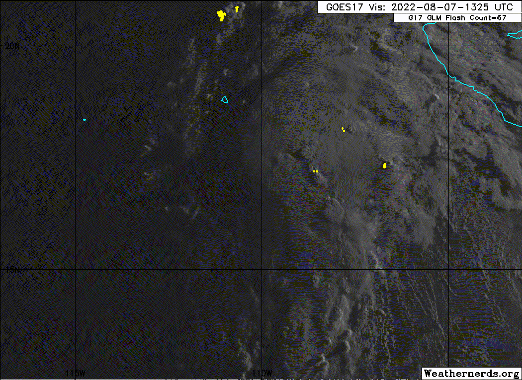
The depression remains disheveled this morning, with the center of
the system still partially exposed to the southwest of the deepest
convective activity. This structure is primarily due to dry air
being imported to the center by moderate southwesterly vertical wind
shear (VWS). Subjective Dvorak intensity estimates were T2.5/35 kt
from TAFB, T2.0/30 kt from SAB, while the latest objective estimate
from UW-CIMSS ADT was T2.5/35 kt. Given the lackluster satellite
presentation, the initial intensity was held at 30 kt for this
advisory.

The depression is now moving northwest as a slightly slower pace,
estimated at 315/10 kt. A mid-level ridge located northeast of the
system is expected to steer it generally northwestward over the next
few days. One interesting note in the immediate future is there is a
weakness in this ridge to the north, partially related to an
upper-level trough currently shearing the depression. If the system
is able to become better aligned vertically, this could lead to a
rightward shift in the short-term track. The NHC track forecast
accounts for this possibility by being located on the right side of
the track guidance envelope over the next 12-36 hours. This track is
just a bit northeast of the previous one, though it blends back
towards the consensus aids by the end of the forecast, when the
system will likely be steered by the low-level trade wind flow.

A weak upper-level trough located northwest of the depression is the
primary feature maintaining southwesterly VWS over the system. Over
the next day or so, both the GFS and ECMWF suggest this feature
should decay and shift southwest, perhaps related to convection
building up-shear around the depression while helping to align its
low and mid-level centers. Should this process occur,
intensification still appears possible. One alternate solution is
that convective outflow is not able to displace the upper-level low
and some amount of shear is maintained over the system. For now, the
latest NHC intensity forecast will maintain a peak of 45 kt in 36-48
hours, right around the time the system will be crossing the 26 C
sea surface temperature (SST) isotherm. After that time, weakening
is expected over even cooler SSTs and a more stable environment. The
system is still expected to become a post-tropical remnant low at
the end of the forecast period. This intensity forecast is on the
high side of the guidance envelope overall, but is close to the
latest HCCA consensus aid.


FORECAST POSITIONS AND MAX WINDS

INIT 07/1500Z 16.8N 109.9W 30 KT 35 MPH
12H 08/0000Z 17.9N 111.1W 35 KT 40 MPH
24H 08/1200Z 19.4N 112.6W 40 KT 45 MPH
36H 09/0000Z 20.7N 114.2W 45 KT 50 MPH
48H 09/1200Z 21.7N 115.9W 45 KT 50 MPH
60H 10/0000Z 22.5N 117.7W 40 KT 45 MPH
72H 10/1200Z 23.1N 119.3W 35 KT 40 MPH
96H 11/1200Z 24.0N 122.5W 30 KT 35 MPH
120H 12/1200Z 24.0N 125.5W 25 KT 30 MPH...POST-TROP/REMNT LOW

$$
Forecaster Papin
0 likes   
Visit the Caribbean-Central America Weather Thread where you can find at first post web cams,radars
and observations from Caribbean basin members Click Here

User avatar
Kingarabian
S2K Supporter
S2K Supporter
Posts: 15432
Joined: Sat Aug 08, 2009 3:06 am
Location: Honolulu, Hawaii

Re: EPAC: NINE-E - Tropical Depression

#38 Postby Kingarabian » Sun Aug 07, 2022 11:43 am

I love Pappin but the format in that last half of the disco kinda confused me. Looks very JTWC'ish.
0 likes   
RIP Kobe Bryant

Sciencerocks
Category 5
Category 5
Posts: 7282
Age: 38
Joined: Thu Jul 06, 2017 1:51 am

Re: EPAC: NINE-E - Tropical Depression

#39 Postby Sciencerocks » Sun Aug 07, 2022 11:56 am

Image
1 likes   

User avatar
cycloneye
Admin
Admin
Posts: 139019
Age: 67
Joined: Thu Oct 10, 2002 10:54 am
Location: San Juan, Puerto Rico

Re: EPAC: NINE-E - Tropical Depression

#40 Postby cycloneye » Sun Aug 07, 2022 2:03 pm

Finnally.

EP, 09, 2022080718, , BEST, 0, 172N, 1104W, 35, 1004, TS
0 likes   
Visit the Caribbean-Central America Weather Thread where you can find at first post web cams,radars
and observations from Caribbean basin members Click Here


Return to “2022”

Who is online

Users browsing this forum: No registered users and 23 guests