https://twitter.com/cyclonicwx/status/1558491378182758400
EPAC: IVETTE - Remnants
Moderator: S2k Moderators
-
cycloneye

- Admin

- Posts: 139029
- Age: 67
- Joined: Thu Oct 10, 2002 10:54 am
- Location: San Juan, Puerto Rico
Re: EPAC: INVEST 90E
0 likes
Visit the Caribbean-Central America Weather Thread where you can find at first post web cams,radars
and observations from Caribbean basin members Click Here
and observations from Caribbean basin members Click Here
-
Kingarabian

- S2K Supporter

- Posts: 15433
- Joined: Sat Aug 08, 2009 3:06 am
- Location: Honolulu, Hawaii
Re: EPAC: INVEST 90E
Recent years, these systems have been waiting until 18-20N 115-110W before getting their acts together. Used to be a time where we would see strong major hurricanes in this area on a regular basis.
0 likes
RIP Kobe Bryant
-
Yellow Evan

- Professional-Met

- Posts: 15951
- Age: 25
- Joined: Fri Jul 15, 2011 12:48 pm
- Location: Henderson, Nevada/Honolulu, HI
- Contact:
Re: EPAC: INVEST 90E

Shocked the NHC hasn’t pulled the trigger yet. ASCAT confirmed a closed center last night and it’s had organized deep convection since 11z.
3 likes
-
Yellow Evan
- Professional-Met
- Posts: 15951
- Age: 25
- Joined: Fri Jul 15, 2011 12:48 pm
- Location: Henderson, Nevada/Honolulu, HI
- Contact:
Re: EPAC: INVEST 90E
Kingarabian wrote:Recent years, these systems have been waiting until 18-20N 115-110W before getting their acts together. Used to be a time where we would see strong major hurricanes in this area on a regular basis.
The monsoon trough is starting to lift northward as expected the time of year and as the equator EPAC cools but it seems Howard contributed to a northward bulge in the monsoon trough as well.
2 likes
-
cycloneye
- Admin
- Posts: 139029
- Age: 67
- Joined: Thu Oct 10, 2002 10:54 am
- Location: San Juan, Puerto Rico
Re: EPAC: INVEST 90E
Tropical Weather Outlook
NWS National Hurricane Center Miami FL
1100 AM PDT Sat Aug 13 2022
For the eastern North Pacific...east of 140 degrees west longitude:
1. Offshore of Southwestern Mexico:
Showers and thunderstorms continue to show signs of organization
in association with an area of low pressure located a few hundred
miles south-southwest of the southern tip of the Baja California
peninsula. If this activity were to continue, a short-lived
tropical depression could form later today or this evening while the
system moves west-northwestward to northwestward at 10 to 15 mph.
By Sunday, upper-level winds are forecast to strengthen over the
system, and further development is not expected.
* Formation chance through 48 hours...high...70 percent.
* Formation chance through 5 days...high...70 percent.
Forecaster Bucci/Brown
0 likes
Visit the Caribbean-Central America Weather Thread where you can find at first post web cams,radars
and observations from Caribbean basin members Click Here
and observations from Caribbean basin members Click Here
-
Yellow Evan
- Professional-Met
- Posts: 15951
- Age: 25
- Joined: Fri Jul 15, 2011 12:48 pm
- Location: Henderson, Nevada/Honolulu, HI
- Contact:
Re: EPAC: INVEST 90E
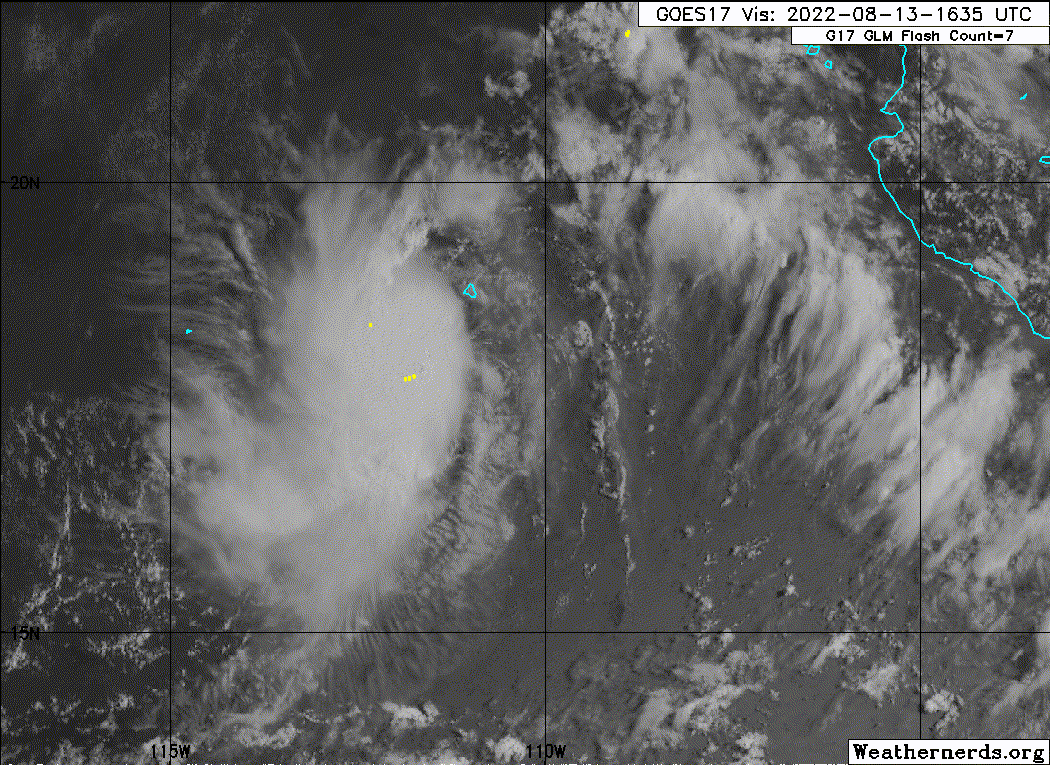
TXPZ22 KNES 131759
TCSENP
A. TROPICAL DISTURBANCE (90E)
B. 13/1730Z
C. 17.7N
D. 111.4W
E. THREE/GOES-W
F. T2.0/2.0
G. IR/EIR/VIS
H. REMARKS...SYSTEM IS CHARACTERIZED BY CIRCULARLY-DEFINED CLOUD LINES
AND A LLCC JUST UNDER A LARGE COLD OVC RESULTING IN A DT OF 2.0. ERLY
SHEAR STILL IMPACTING SYSTEM. MET AND PT=2.0. FT IS BASED ON MET DUE TO
UNCERTAINTY OF EXACT LOCATION OF LLCC.
I. ADDL POSITIONS
NIL
...KONON
0 likes

-
Yellow Evan
- Professional-Met
- Posts: 15951
- Age: 25
- Joined: Fri Jul 15, 2011 12:48 pm
- Location: Henderson, Nevada/Honolulu, HI
- Contact:
Re: EPAC: INVEST 90E
EP, 10, 2022081318, , BEST, 0, 179N, 1113W, 30, 1007, TD, 34, NEQ, 0, 0, 0, 0, 1011, 120, 30, 0, 0, E, 0, , 0, 0, TEN, S, 0, , 0, 0, 0, 0, genesis-num, 015, TRANSITIONED, epB02022 to ep102022
1 likes
-
Kingarabian
- S2K Supporter
- Posts: 15433
- Joined: Sat Aug 08, 2009 3:06 am
- Location: Honolulu, Hawaii
-
Sciencerocks
- Category 5

- Posts: 7282
- Age: 38
- Joined: Thu Jul 06, 2017 1:51 am
-
cycloneye
- Admin
- Posts: 139029
- Age: 67
- Joined: Thu Oct 10, 2002 10:54 am
- Location: San Juan, Puerto Rico
Re: EPAC: TEN-E - Tropical Depression
BULLETIN
Tropical Depression Ten-E Advisory Number 1
NWS National Hurricane Center Miami FL EP102022
300 PM MDT Sat Aug 13 2022
...NEW TROPICAL DEPRESSION FORMS...
...EXPECTED TO BE SHORT-LIVED...
SUMMARY OF 300 PM MDT...2100 UTC...INFORMATION
----------------------------------------------
LOCATION...18.0N 111.5W
ABOUT 355 MI...570 KM SSW OF THE SOUTHERN TIP OF BAJA CALIFORNIA
MAXIMUM SUSTAINED WINDS...35 MPH...55 KM/H
PRESENT MOVEMENT...WNW OR 290 DEGREES AT 10 MPH...17 KM/H
MINIMUM CENTRAL PRESSURE...1007 MB...29.74 INCHES
Tropical Depression Ten-E Discussion Number 1
NWS National Hurricane Center Miami FL EP102022
300 PM MDT Sat Aug 13 2022
Recent scatterometer data indicated that the circulation associated
with the low pressure area that NHC has been tracking over the
previous few days has become better defined within the past 24
hours. Although convection is limited to the western portion of
the circulation, the system has had sufficient organized and
persistent thunderstorm activity to be classified as a tropical
depression. The initial wind speed is set at 30 kt and is based on
a blend of the satellite-derived surface wind speeds and the Dvorak
classifications from SAB and TAFB.
The depression is not expected to strengthen and be a rather
short-lived tropical cyclone. The system is currently within an
area of modest northeasterly shear and the upper-level winds are
forecast to increase within the next 24 hours. Although the
forecast does not explicitly call for the system to become a
tropical storm, it could strengthen slightly within the next 12-24
hours. After that time frame, the vertical wind shear is predicted
to increase and limit any further intensification. The official
forecast shows the depression becoming a remnant low by 48 hours.
The system is moving west-northwestward at 9 kt around the
southwestern portion of a mid-level ridge over northwestern Mexico.
The ridge is forecast to build westward over the next day or two,
which should cause the depression to turn westward. As the vortex
weakens and becomes more shallow, it should slow in forward speed
and drift west-southwestward. The NHC track forecast is near the
middle of the guidance envelope, close to the model consensus aids.
FORECAST POSITIONS AND MAX WINDS
INIT 13/2100Z 18.0N 111.5W 30 KT 35 MPH
12H 14/0600Z 18.3N 112.7W 30 KT 35 MPH
24H 14/1800Z 18.6N 113.9W 30 KT 35 MPH
36H 15/0600Z 18.5N 114.5W 25 KT 30 MPH
48H 15/1800Z 18.2N 114.9W 20 KT 25 MPH...POST-TROP/REMNT LOW
60H 16/0600Z 17.9N 115.3W 20 KT 25 MPH...POST-TROP/REMNT LOW
72H 16/1800Z...DISSIPATED
$$
Forecaster Bucci/Brown
0 likes
Visit the Caribbean-Central America Weather Thread where you can find at first post web cams,radars
and observations from Caribbean basin members Click Here
and observations from Caribbean basin members Click Here
-
Iceresistance

- Category 5
- Posts: 8911
- Age: 20
- Joined: Sat Oct 10, 2020 9:45 am
- Location: Tecumseh, OK/Norman, OK
Re: EPAC: TEN-E - Tropical Depression
Exposed to the east already. (It's to the SW)

https://s4.gifyu.com/images/CODNEXLAB-GOES-East-regional-southmexico-natcolor-21_11Z-20220813_map_-35-1n-25-50.gif
https://s4.gifyu.com/images/CODNEXLAB-GOES-East-regional-southmexico-natcolor-21_11Z-20220813_map_-35-1n-25-50.gif
0 likes
Bill 2015 & Beta 2020
Winter 2020-2021
All observations are in Tecumseh, OK unless otherwise noted.
Winter posts are focused mainly for Oklahoma & Texas.
Take any of my forecasts with a grain of salt, refer to the NWS, SPC, and NHC for official information
Never say Never with weather! Because ANYTHING is possible!
Winter 2020-2021
All observations are in Tecumseh, OK unless otherwise noted.
Winter posts are focused mainly for Oklahoma & Texas.
Take any of my forecasts with a grain of salt, refer to the NWS, SPC, and NHC for official information
Never say Never with weather! Because ANYTHING is possible!
-
wxman57

- Moderator-Pro Met

- Posts: 22480
- Age: 66
- Joined: Sat Jun 21, 2003 8:06 pm
- Location: Houston, TX (southwest)
Re: EPAC: TEN-E - Tropical Depression
Exposed center east of some convection. It's already being sheared apart. Not much of a future.
1 likes
-
cycloneye
- Admin
- Posts: 139029
- Age: 67
- Joined: Thu Oct 10, 2002 10:54 am
- Location: San Juan, Puerto Rico
Re: EPAC: TEN-E - Tropical Depression
Tropical Depression Ten-E Discussion Number 2
NWS National Hurricane Center Miami FL EP102022
900 PM MDT Sat Aug 13 2022
The depression has maintained a sheared appearance in satellite
imagery this evening. The low-level center is exposed to the east of
its deep convective overcast, which has a sharp eastern edge as
moderate east-northeasterly shear continues to impinge on its
circulation. The distance between the center and the cold overcast
has slightly increased from earlier today, and the initial intensity
is held at 30 kt for this advisory. This is consistent with a blend
of the various objective and subjective satellite estimates, which
range from 25 to 35 kt.
Ten-E is expected to be a short-lived tropical cyclone, as the
moderate deep-layer shear currently plaguing the system is forecast
to strengthen during the next couple of days. So although SSTs
remain above 26 deg C along its forecast track, the shear will
continue to disrupt the system's vertical organization and import
drier mid-level air from the east into its circulation. The official
NHC forecast shows little change in strength during the next 12-24
h, followed by gradual weakening as the system is forecast to lose
deep organized convection and degenerate into a remnant low in 36 h.
The remnant low could meander for a day or so before it succumbs to
increased shear and drier air and eventually opens into a trough.
The depression is still moving west-northwestward (285/7 kt) around
a low- to mid-level ridge over northern Mexico. The vertically
shallow system should gradually turn westward to west-southwestward
over the next couple of days as it becomes steered by the low-level
flow. The latest NHC track forecast is very similar to the previous
one and remains close to the multi-model consensus aids.
FORECAST POSITIONS AND MAX WINDS
INIT 14/0300Z 18.2N 112.2W 30 KT 35 MPH
12H 14/1200Z 18.4N 113.2W 30 KT 35 MPH
24H 15/0000Z 18.5N 114.1W 30 KT 35 MPH
36H 15/1200Z 18.4N 114.6W 25 KT 30 MPH...POST-TROP/REMNT LOW
48H 16/0000Z 18.2N 115.0W 20 KT 25 MPH...POST-TROP/REMNT LOW
60H 16/1200Z 17.9N 115.5W 20 KT 25 MPH...POST-TROP/REMNT LOW
72H 17/0000Z...DISSIPATED
$$
Forecaster Reinhart
0 likes
Visit the Caribbean-Central America Weather Thread where you can find at first post web cams,radars
and observations from Caribbean basin members Click Here
and observations from Caribbean basin members Click Here
-
Sciencerocks
- Category 5
- Posts: 7282
- Age: 38
- Joined: Thu Jul 06, 2017 1:51 am
-
cycloneye
- Admin
- Posts: 139029
- Age: 67
- Joined: Thu Oct 10, 2002 10:54 am
- Location: San Juan, Puerto Rico
Re: EPAC: TEN-E - Tropical Depression
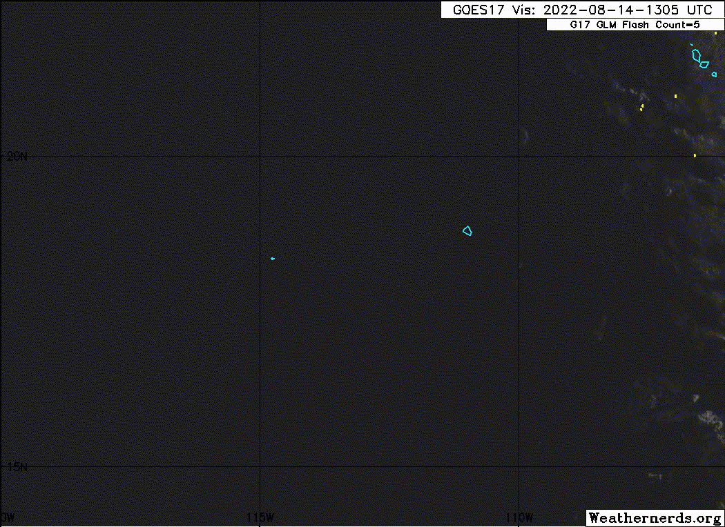
Tropical Depression Ten-E Discussion Number 3
NWS National Hurricane Center Miami FL EP102022
300 AM MDT Sun Aug 14 2022
The depression is struggling against strong easterly shear, and the
exposed low-level circulation center is now about 70 n mi from the
edge of its associated deep convection. The initial intensity is
held at 30 kt for this advisory, which is a blend of the latest
Dvorak T-numbers from TAFB, SAB, and the UW-CIMSS ADT.
The shear impacting the cyclone is forecast to increase even more
over the next day or so. The combination of this shear and dry
mid-level air entraining into the depression's circulation is
expected to disrupt the development of significant deep convection
near its center. GFS and ECMWF simulated satellite imagery suggest
that perhaps a short-lived diurnal cycle of convection could develop
near the center of the depression later this morning. Thereafter,
those models suggest the system will degenerate into a remnant low,
and the NHC forecast indicates that the depression should become a
remnant low as soon as tonight. With an anticipated lack of
appreciable deep convection near the cyclone's center, no
strengthening is forecast. The system is expected to slowly weaken
early this week and dissipate by midweek.
The depression's low-level circulation has slowed its forward
motion and is now moving at 295/5 kt to the southwest of a low- to
mid-level ridge. This motion is expected to continue through today.
As the cyclone loses its convection, a turn westward then
west-southwestward is expected as the system becomes steered by the
surrounding low-level flow. The latest NHC track forecast remains
very similar to the previous one and is close to the multi-model
consensus aids.
FORECAST POSITIONS AND MAX WINDS
INIT 14/0900Z 18.4N 112.6W 30 KT 35 MPH
12H 14/1800Z 18.5N 113.4W 30 KT 35 MPH
24H 15/0600Z 18.5N 114.1W 30 KT 35 MPH...POST-TROP/REMNT LOW
36H 15/1800Z 18.4N 114.7W 25 KT 30 MPH...POST-TROP/REMNT LOW
48H 16/0600Z 18.2N 115.2W 20 KT 25 MPH...POST-TROP/REMNT LOW
60H 16/1800Z 18.0N 115.7W 20 KT 25 MPH...POST-TROP/REMNT LOW
72H 17/0600Z...DISSIPATED
$$
Forecaster Latto
0 likes
Visit the Caribbean-Central America Weather Thread where you can find at first post web cams,radars
and observations from Caribbean basin members Click Here
and observations from Caribbean basin members Click Here
-
cycloneye
- Admin
- Posts: 139029
- Age: 67
- Joined: Thu Oct 10, 2002 10:54 am
- Location: San Juan, Puerto Rico
Re: EPAC: TEN-E - Tropical Depression
Tropical Depression Ten-E Discussion Number 4
NWS National Hurricane Center Miami FL EP102022
900 AM MDT Sun Aug 14 2022
There has been little change in the structure of the tropical
depression since the previous advisory. The center remains exposed
to the northeast of the associated deep convection due to the
presence of moderate to strong east-northeasterly shear. Since
there has been no change in the system's organization, the initial
intensity is held at 30 kt. Some of the objective and subjective
satellite estimates from TAFB and UW/CIMSS suggest the system could
be slightly stronger, but given the lack of overall organization it
is best to stay on the conservative side until scatterometer data
is potentially available later today.
The vertical wind shear affecting the system is forecast to increase
within the next 24 hours, and that is likely to prevent
strengthening. Simulated satellite imagery from the global models
suggest bursts of deep convection are likely to continue over the
western portion of the circulation through tonight. After that time,
the system is forecast to degenerate into a remnant low and gradual
weakening should occur through midweek.
The cyclone is moving west-northwestward at about 4 kt. A low- to
mid-level ridge to the north of the depression is expected to cause
the cyclone to turn westward later today. As the low weakens it is
forecast to turn west-southwestward within the low-level flow. The
new NHC track forecast is again similar to the previous advisory
and is close to the various consensus aids.
FORECAST POSITIONS AND MAX WINDS
INIT 14/1500Z 18.3N 113.1W 30 KT 35 MPH
12H 15/0000Z 18.5N 113.6W 30 KT 35 MPH
24H 15/1200Z 18.5N 114.2W 30 KT 35 MPH...POST-TROP/REMNT LOW
36H 16/0000Z 18.3N 114.8W 25 KT 30 MPH...POST-TROP/REMNT LOW
48H 16/1200Z 18.1N 115.3W 20 KT 25 MPH...POST-TROP/REMNT LOW
60H 17/0000Z 18.0N 116.0W 20 KT 25 MPH...POST-TROP/REMNT LOW
72H 17/1200Z 18.0N 117.0W 20 KT 25 MPH...POST-TROP/REMNT LOW
96H 18/1200Z...DISSIPATED
$$
Forecaster Brown
0 likes
Visit the Caribbean-Central America Weather Thread where you can find at first post web cams,radars
and observations from Caribbean basin members Click Here
and observations from Caribbean basin members Click Here

Re: EPAC: TEN-E - Tropical Depression
What a massive bust. This wasted so much time trying to form and fell so far below the GFS, HWRF, and other intensity models.
1 likes
Irene '11 Sandy '12 Hermine '16 5/15/2018 Derecho Fay '20 Isaias '20 Elsa '21 Henri '21 Ida '21
I am only a meteorology enthusiast who knows a decent amount about tropical cyclones. Look to the professional mets, the NHC, or your local weather office for the best information.
I am only a meteorology enthusiast who knows a decent amount about tropical cyclones. Look to the professional mets, the NHC, or your local weather office for the best information.
-
Yellow Evan
- Professional-Met
- Posts: 15951
- Age: 25
- Joined: Fri Jul 15, 2011 12:48 pm
- Location: Henderson, Nevada/Honolulu, HI
- Contact:
Re: EPAC: INVEST 90E
aspen wrote:What a massive bust. This wasted so much time trying to form and fell so far below the GFS, HWRF, and other intensity models.
aspen wrote:The 06z HWRF turns this into another annular hurricane, simile to Howard but it gets much stronger because it starts intensifying earlier. I don’t really buy any quick development scenarios after the last few storms have struggled early on.
These two statements contradict each other with all due respect. Even the GFS only made this strong for a couple runs and its issues in the medium range is well known at this point.
0 likes
-
Sciencerocks
- Category 5
- Posts: 7282
- Age: 38
- Joined: Thu Jul 06, 2017 1:51 am
Who is online
Users browsing this forum: No registered users and 9 guests