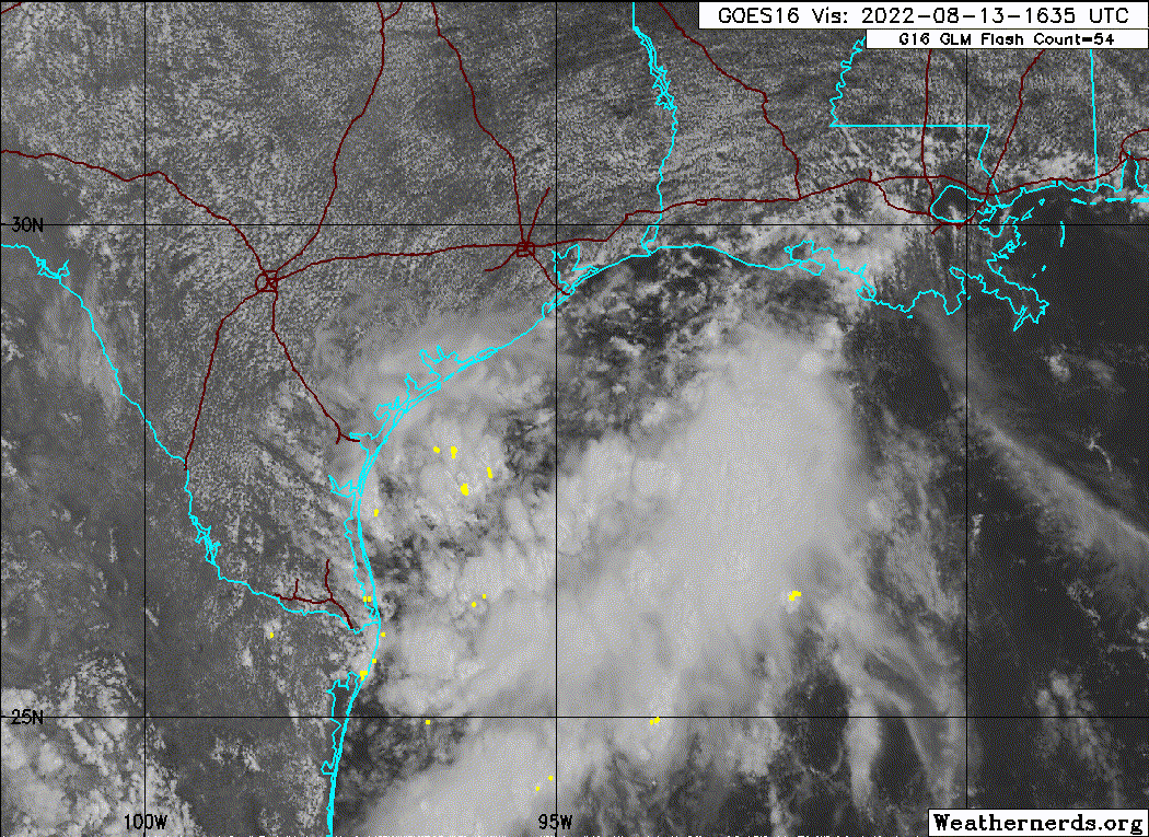
Based off those radar loops, it looks a lot better than yesterday. Maybe the coast is helping?
29.93 in is the lowest pressure I can find from our buoys, but they were higher 24 hours ago.
ATL: Ex INVEST 98L - Discussion
Moderator: S2k Moderators
-
lrak

- S2K Supporter

- Posts: 1770
- Age: 57
- Joined: Thu Jun 21, 2007 2:48 pm
- Location: Corpus Christi, TX
Re: ATL: INVEST 98L - Discussion
1 likes
AKA karl
Also
Personal Forecast Disclaimer:
My posts on this forum are NOT official forecast and should not be used as such. My posts are my basic observations and are definitely not backed by any "well some" meteorological knowledge. For official information, please refer to the NHC and NWS products.
Also
Personal Forecast Disclaimer:
My posts on this forum are NOT official forecast and should not be used as such. My posts are my basic observations and are definitely not backed by any "well some" meteorological knowledge. For official information, please refer to the NHC and NWS products.

-
Sciencerocks
- Category 5

- Posts: 7282
- Age: 38
- Joined: Thu Jul 06, 2017 1:51 am
Re: ATL: INVEST 98L - Discussion
I think it has about 50% imo. Broad LLC and convection.  We will see what happens but I wouldn't be shocked to see a quick tropical storm.
1 likes
-
Craters
- Category 1

- Posts: 349
- Joined: Sat Aug 24, 2013 2:34 pm
- Location: Alvin, TX (south of Houston)
Re: ATL: INVEST 98L - Discussion
Currently getting some rain bands in Brazoria and Galveston counties. Decent but short intervals of heavy rain, but it just doesn't have that tropical "feel" out there that we'd normally have with a system trying to rev up off the coast.
For what it's worth. . .
For what it's worth. . .
2 likes
Nothing that I post here should ever be treated as a forecast or anything resembling one. Please check with your local NWS office or the NHC for forecasts, watches, and warnings.
-
MGC

- S2K Supporter
- Posts: 5792
- Joined: Sun Mar 23, 2003 9:05 pm
- Location: Pass Christian MS, or what is left.
Re: ATL: INVEST 98L - Discussion
Still a sharp trough oriented SW-NE. Considerable increase in convection since this morning, doubt it has time left to close off......MGC
1 likes
-
Kingarabian

- S2K Supporter
- Posts: 15432
- Joined: Sat Aug 08, 2009 3:06 am
- Location: Honolulu, Hawaii
-
Sciencerocks
- Category 5
- Posts: 7282
- Age: 38
- Joined: Thu Jul 06, 2017 1:51 am
-
tolakram
- Admin

- Posts: 19165
- Age: 60
- Joined: Sun Aug 27, 2006 8:23 pm
- Location: Florence, KY (name is Mark)
Re: ATL: INVEST 98L - Discussion
Floater: https://weather.cod.edu/satrad/?parms=meso-meso1-natcolor-96-1-100-1&checked=map&colorbar=undefined
Sub Regional RGB https://weather.cod.edu/satrad/?parms=subregional-W_Gulf_Coast-natcolor-96-1-100-1&checked=map&colorbar=undefined
Sub Regional RGB https://weather.cod.edu/satrad/?parms=subregional-W_Gulf_Coast-natcolor-96-1-100-1&checked=map&colorbar=undefined
0 likes
M a r k
- - - - -
Join us in chat: Storm2K Chatroom Invite. Android and IOS apps also available.
The posts in this forum are NOT official forecasts and should not be used as such. Posts are NOT endorsed by any professional institution or STORM2K.org. For official information and forecasts, please refer to NHC and NWS products.
-
tolakram
- Admin
- Posts: 19165
- Age: 60
- Joined: Sun Aug 27, 2006 8:23 pm
- Location: Florence, KY (name is Mark)
Re: ATL: INVEST 98L - Discussion
0 likes
M a r k
- - - - -
Join us in chat: Storm2K Chatroom Invite. Android and IOS apps also available.
The posts in this forum are NOT official forecasts and should not be used as such. Posts are NOT endorsed by any professional institution or STORM2K.org. For official information and forecasts, please refer to NHC and NWS products.
- - - - -
Join us in chat: Storm2K Chatroom Invite. Android and IOS apps also available.
The posts in this forum are NOT official forecasts and should not be used as such. Posts are NOT endorsed by any professional institution or STORM2K.org. For official information and forecasts, please refer to NHC and NWS products.

Re: ATL: INVEST 98L - Discussion
Kingarabian wrote:Shouldn't this be designated a PTC?
I think a PTC designation is only used when the disturbance has a 70%+ chance of development ("red") and with <=48 hours before land impacts. Since NHC currently gives a 20% chance, it won't be called a PTC.
1 likes
-
jaguars_22
- Category 1
- Posts: 493
- Joined: Tue Jun 20, 2017 2:26 pm
Re: ATL: INVEST 98L - Discussion
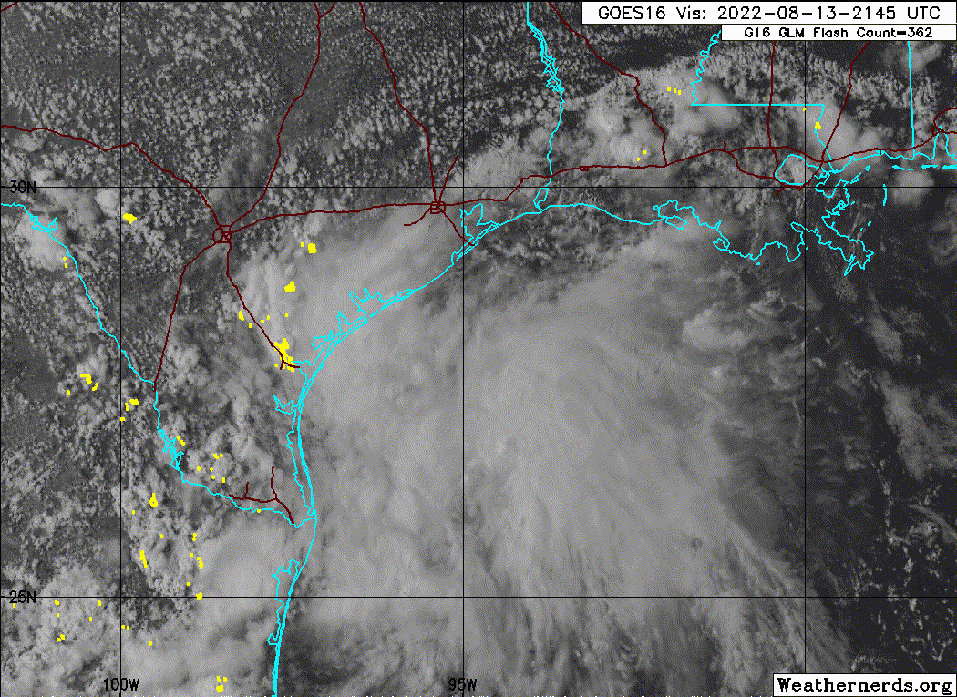
So it looks like this storm will be 2 pieces. One to the north and one to the south… hopefully they both remain moist and bring most of the coast rain!
0 likes
-
tolakram
- Admin
- Posts: 19165
- Age: 60
- Joined: Sun Aug 27, 2006 8:23 pm
- Location: Florence, KY (name is Mark)
Re: ATL: INVEST 98L - Discussion
Convection fading again
saved loop

saved loop
0 likes
M a r k
- - - - -
Join us in chat: Storm2K Chatroom Invite. Android and IOS apps also available.
The posts in this forum are NOT official forecasts and should not be used as such. Posts are NOT endorsed by any professional institution or STORM2K.org. For official information and forecasts, please refer to NHC and NWS products.
- - - - -
Join us in chat: Storm2K Chatroom Invite. Android and IOS apps also available.
The posts in this forum are NOT official forecasts and should not be used as such. Posts are NOT endorsed by any professional institution or STORM2K.org. For official information and forecasts, please refer to NHC and NWS products.
-
tolakram
- Admin
- Posts: 19165
- Age: 60
- Joined: Sun Aug 27, 2006 8:23 pm
- Location: Florence, KY (name is Mark)
Re: ATL: INVEST 98L - Discussion
^^^ this might be storms near the radar site

0 likes
M a r k
- - - - -
Join us in chat: Storm2K Chatroom Invite. Android and IOS apps also available.
The posts in this forum are NOT official forecasts and should not be used as such. Posts are NOT endorsed by any professional institution or STORM2K.org. For official information and forecasts, please refer to NHC and NWS products.
- - - - -
Join us in chat: Storm2K Chatroom Invite. Android and IOS apps also available.
The posts in this forum are NOT official forecasts and should not be used as such. Posts are NOT endorsed by any professional institution or STORM2K.org. For official information and forecasts, please refer to NHC and NWS products.

Re: ATL: INVEST 98L - Discussion
jaguars_22 wrote:So it looks like this storm will be 2 pieces. One to the north and one to the south… hopefully they both remain moist and bring most of the coast rain!
I think what happens is that the northern ball fades away, and new storms fire up along the coast or just inland overnight.
0 likes
-
cycloneye

- Admin
- Posts: 139027
- Age: 67
- Joined: Thu Oct 10, 2002 10:54 am
- Location: San Juan, Puerto Rico
Re: ATL: INVEST 98L - Discussion
1 likes
Visit the Caribbean-Central America Weather Thread where you can find at first post web cams,radars
and observations from Caribbean basin members Click Here
and observations from Caribbean basin members Click Here
-
cycloneye
- Admin
- Posts: 139027
- Age: 67
- Joined: Thu Oct 10, 2002 10:54 am
- Location: San Juan, Puerto Rico
Re: ATL: INVEST 98L - Discussion
Tropical Weather Outlook
NWS National Hurricane Center Miami FL
800 PM EDT Sat Aug 13 2022
For the North Atlantic...Caribbean Sea and the Gulf of Mexico:
1. Northwestern Gulf of Mexico:
Shower and thunderstorm activity associated with a broad low
pressure area just off the Texas coast has weakened a bit during
the past few hours. The disturbance is forecast to continue moving
slowly west-southwestward and approach the Texas coast tonight,
and then move inland over southern Texas Sunday morning. Although
there is some potential for land interaction to cause the
disturbance to become better defined while moving onshore Sunday
morning, significant development of the system is not anticipated.
Regardless of development, heavy rains are forecast across southern
Texas through Monday, which could cause localized areas of flash
flooding. For more information about the potential for heavy
rainfall, please see products issued by your local National Weather
Service office and the Weather Prediction Center.
* Formation chance through 48 hours...low...20 percent.
* Formation chance through 5 days...low...20 percent.
For more information on the system, see products issued by the
National Weather Service at weather.gov and wpc.ncep.noaa.gov
Forecaster Berg
0 likes
Visit the Caribbean-Central America Weather Thread where you can find at first post web cams,radars
and observations from Caribbean basin members Click Here
and observations from Caribbean basin members Click Here
-
wxman57

- Moderator-Pro Met

- Posts: 22480
- Age: 66
- Joined: Sat Jun 21, 2003 8:06 pm
- Location: Houston, TX (southwest)
Re: ATL: INVEST 98L - Discussion
Kingarabian wrote:Shouldn't this be designated a PTC?
No. A PTC would be issued if tropical storm watches or warnings are needed. They're not. At worst, this could be called a depression as it moves inland tonight. Winds 15-20 kts offshore with higher gusts in thunderstorms, whether or not the NHC calls it a depression before it moves inland.
2 likes
Re: ATL: INVEST 98L - Discussion
I agree with Dylan. Models that had this earlier in the week did show pulsing up at the coast or just inland.
0 likes
-
Sciencerocks
- Category 5
- Posts: 7282
- Age: 38
- Joined: Thu Jul 06, 2017 1:51 am
-
Kingarabian
- S2K Supporter
- Posts: 15432
- Joined: Sat Aug 08, 2009 3:06 am
- Location: Honolulu, Hawaii
Re: ATL: INVEST 98L - Discussion
HMON and HWRF relocate the center within the next 24 hours and landfall it near or at TS strength.
But it's looking pretty dead convection wise.
But it's looking pretty dead convection wise.
2 likes
RIP Kobe Bryant
Who is online
Users browsing this forum: No registered users and 26 guests