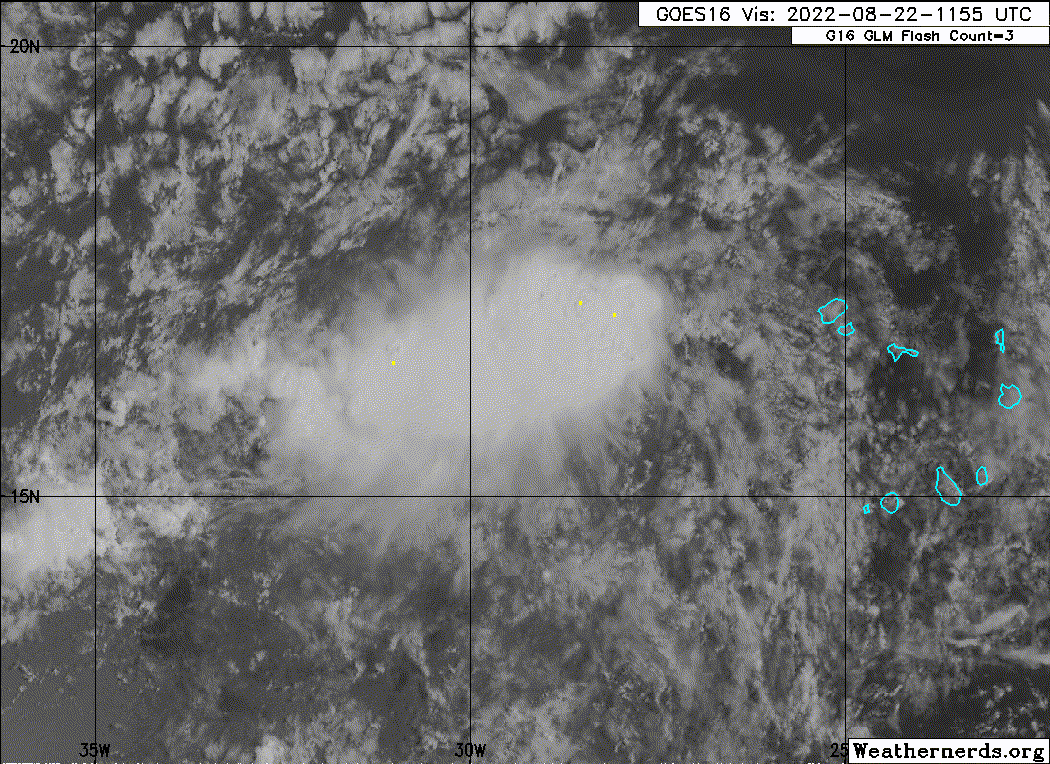
ATL: Ex INVEST 90L - Discussion

Moderator: S2k Moderators

Message
Author
User avatar
Nancy Smar
Category 5
Category 5
Posts: 1081
Age: 23
Joined: Wed Aug 16, 2017 10:03 pm

ATL: Ex INVEST 90L - Discussion

#1 Postby Nancy Smar » Mon Aug 22, 2022 8:43 am

AL902022 - INVEST
Synoptic Time Latitude Longitude Intensity
2022-08-22 12:00 16.2 -29.3 25

https://rammb-data.cira.colostate.edu/tc_realtime/storm.asp?storm_identifier=al902022

https://www.ssd.noaa.gov/PS/TROP/DATA/ATCF/NHC/
0 likes   

User avatar
cycloneye
Admin
Admin
Posts: 139052
Age: 67
Joined: Thu Oct 10, 2002 10:54 am
Location: San Juan, Puerto Rico

Re: ATL: INVEST 90L - Discussion

#2 Postby cycloneye » Mon Aug 22, 2022 8:49 am

Image
0 likes   
Visit the Caribbean-Central America Weather Thread where you can find at first post web cams,radars
and observations from Caribbean basin members Click Here

User avatar
ElectricStorm
Category 5
Category 5
Posts: 4526
Age: 23
Joined: Tue Aug 13, 2019 11:23 pm
Location: Skiatook, OK / Norman, OK

Re: ATL: INVEST 90L - Discussion

#3 Postby ElectricStorm » Mon Aug 22, 2022 8:50 am

This one will need to be watched once it gets further west. Will probably stay weak until then
1 likes   
I am in no way a professional. Take what I say with a grain of salt as I could be totally wrong. Please refer to the NHC, NWS, or SPC for official information.

Boomer Sooner!

User avatar
Nancy Smar
Category 5
Category 5
Posts: 1081
Age: 23
Joined: Wed Aug 16, 2017 10:03 pm

Re: ATL: INVEST 90L - Discussion

#4 Postby Nancy Smar » Mon Aug 22, 2022 8:58 am

AL, 90, 2022082212, , BEST, 0, 162N, 293W, 25, 1010, DB, 34, NEQ, 0, 0, 0, 0, 1012, 150, 30, 0, 0, L, 0, , 0, 0, INVEST, S, 0, , 0, 0, 0, 0, genesis-num, 017, SPAWNINVEST, al782022 to al902022,
0 likes   

User avatar
SFLcane
S2K Supporter
S2K Supporter
Posts: 9606
Age: 46
Joined: Sat Jun 05, 2010 1:44 pm
Location: Lake Worth Florida

Re: ATL: INVEST 90L - Discussion

#5 Postby SFLcane » Mon Aug 22, 2022 9:03 am

Nancy Smar wrote:
AL, 90, 2022082212, , BEST, 0, 162N, 293W, 25, 1010, DB, 34, NEQ, 0, 0, 0, 0, 1012, 150, 30, 0, 0, L, 0, , 0, 0, INVEST, S, 0, , 0, 0, 0, 0, genesis-num, 017, SPAWNINVEST, al782022 to al902022,


Were is this?

https://t.co/10RhJ5aXkW
0 likes   

User avatar
Nancy Smar
Category 5
Category 5
Posts: 1081
Age: 23
Joined: Wed Aug 16, 2017 10:03 pm

Re: ATL: INVEST 90L - Discussion

#6 Postby Nancy Smar » Mon Aug 22, 2022 9:10 am

SFLcane wrote:
Nancy Smar wrote:
AL, 90, 2022082212, , BEST, 0, 162N, 293W, 25, 1010, DB, 34, NEQ, 0, 0, 0, 0, 1012, 150, 30, 0, 0, L, 0, , 0, 0, INVEST, S, 0, , 0, 0, 0, 0, genesis-num, 017, SPAWNINVEST, al782022 to al902022,


Were is this?

https://t.co/10RhJ5aXkW

https://www.ssd.noaa.gov/PS/TROP/DATA/ATCF/NHC/bal902022.dat
0 likes   

User avatar
SFLcane
S2K Supporter
S2K Supporter
Posts: 9606
Age: 46
Joined: Sat Jun 05, 2010 1:44 pm
Location: Lake Worth Florida

Re: ATL: INVEST 90L - Discussion

#7 Postby SFLcane » Mon Aug 22, 2022 9:13 am

Nancy Smar wrote:
SFLcane wrote:
Nancy Smar wrote:
AL, 90, 2022082212, , BEST, 0, 162N, 293W, 25, 1010, DB, 34, NEQ, 0, 0, 0, 0, 1012, 150, 30, 0, 0, L, 0, , 0, 0, INVEST, S, 0, , 0, 0, 0, 0, genesis-num, 017, SPAWNINVEST, al782022 to al902022,


Were is this?

https://t.co/10RhJ5aXkW

https://www.ssd.noaa.gov/PS/TROP/DATA/ATCF/NHC/bal902022.dat


Hmmm OK. I don't see SHIPS data yet though.
0 likes   

User avatar
cycloneye
Admin
Admin
Posts: 139052
Age: 67
Joined: Thu Oct 10, 2002 10:54 am
Location: San Juan, Puerto Rico

Re: ATL: INVEST 90L - Discussion

#8 Postby cycloneye » Mon Aug 22, 2022 9:18 am

What I see is FNMOC has it but ATCF still does not and that is why there are no SHIP plots yet.
0 likes   
Visit the Caribbean-Central America Weather Thread where you can find at first post web cams,radars
and observations from Caribbean basin members Click Here

User avatar
cycloneye
Admin
Admin
Posts: 139052
Age: 67
Joined: Thu Oct 10, 2002 10:54 am
Location: San Juan, Puerto Rico

Re: ATL: INVEST 90L - Discussion

#9 Postby cycloneye » Mon Aug 22, 2022 9:22 am

SFLcane wrote:


Hmmm OK. I don't see SHIPS data yet though.


Here is the link from where Nancy got it. Bookmark it.

https://www.ssd.noaa.gov/PS/TROP/DATA/ATCF/NHC/
3 likes   
Visit the Caribbean-Central America Weather Thread where you can find at first post web cams,radars
and observations from Caribbean basin members Click Here

User avatar
SFLcane
S2K Supporter
S2K Supporter
Posts: 9606
Age: 46
Joined: Sat Jun 05, 2010 1:44 pm
Location: Lake Worth Florida

Re: ATL: INVEST 90L - Discussion

#10 Postby SFLcane » Mon Aug 22, 2022 9:34 am

cycloneye wrote:
SFLcane wrote:


Hmmm OK. I don't see SHIPS data yet though.


Here is the link from where Nancy got it. Bookmark it.

https://www.ssd.noaa.gov/PS/TROP/DATA/ATCF/NHC/


Yeah saw it there but still not on NHC ftp.
0 likes   

LarryWx
Category 5
Category 5
Posts: 5699
Joined: Sun Sep 07, 2003 2:04 pm
Location: GA

Re: ATL: INVEST 90L - Discussion

#11 Postby LarryWx » Mon Aug 22, 2022 10:01 am

Look out, this low's circ/convection centered on 16N, 30W, is so far holding off the nearby SAL and has held on well past DMAX, This is about as impressive as anything in the MDR seen since what lead to Bonnie in late June:

Image
Last edited by LarryWx on Mon Aug 22, 2022 10:04 am, edited 1 time in total.
0 likes   
Personal Forecast Disclaimer:
The posts in this forum are NOT official forecasts and should not be used as such. They are just the opinion of the poster and may or may not be backed by sound meteorological data. They are NOT endorsed by any professional institution or storm2k.org. For official information, please refer to the NHC and NWS products.

User avatar
cycloneye
Admin
Admin
Posts: 139052
Age: 67
Joined: Thu Oct 10, 2002 10:54 am
Location: San Juan, Puerto Rico

Re: ATL: INVEST 90L - Discussion

#12 Postby cycloneye » Mon Aug 22, 2022 10:03 am

SFLCane ATCF now is up so SHIP will run it's first plots.

AL, 90, 2022082212, , BEST, 0, 162N, 293W, 25, 1010, DB, 34, NEQ, 0, 0, 0, 0, 1012, 150, 30, 0, 0, L, 0, , 0, 0, INVEST, S, 0, , 0, 0, 0, 0, genesis-num, 017, SPAWNINVEST, al782022 to al902022,

https://ftp.nhc.noaa.gov/atcf/btk/?C=M;O=D
1 likes   
Visit the Caribbean-Central America Weather Thread where you can find at first post web cams,radars
and observations from Caribbean basin members Click Here

User avatar
SoupBone
Category 5
Category 5
Posts: 3073
Joined: Tue Sep 20, 2005 5:24 pm

Re: ATL: INVEST 90L - Discussion

#13 Postby SoupBone » Mon Aug 22, 2022 10:10 am

Yeah this one might get us to a name before the month's end, unfortunately. It seems that conditions aren't that horrible, besides SAL in its way.
0 likes   
Personal Forecast Disclaimer:
The posts in this forum are NOT official forecast and should not be used as such. They are just the opinion of the poster and may or may not be backed by sound meteorological data. They are NOT endorsed by any professional institution or storm2k.org. For official information, please refer to the NHC and NWS products.

User avatar
SFLcane
S2K Supporter
S2K Supporter
Posts: 9606
Age: 46
Joined: Sat Jun 05, 2010 1:44 pm
Location: Lake Worth Florida

Re: ATL: INVEST 90L - Discussion

#14 Postby SFLcane » Mon Aug 22, 2022 10:12 am

Haircut coming at Day 4.
0 likes   

User avatar
SFLcane
S2K Supporter
S2K Supporter
Posts: 9606
Age: 46
Joined: Sat Jun 05, 2010 1:44 pm
Location: Lake Worth Florida

Re: ATL: INVEST 90L - Discussion

#15 Postby SFLcane » Mon Aug 22, 2022 10:14 am

LarryWx wrote:Look out, this low's circ/convection centered on 16N, 30W, is so far holding off the nearby SAL and has held on well past DMAX, This is about as impressive as anything in the MDR seen since what lead to Bonnie in late June:

https://i.imgur.com/CwJKjmI.jpg


Yeah we'll see if it persists.
0 likes   

User avatar
Kingarabian
S2K Supporter
S2K Supporter
Posts: 15434
Joined: Sat Aug 08, 2009 3:06 am
Location: Honolulu, Hawaii

Re: ATL: INVEST 90L - Discussion

#16 Postby Kingarabian » Mon Aug 22, 2022 10:17 am

That TUTT could end up being a bad thing if all it does is delay development until this is close to land, and the ridge builds back.
4 likes   
RIP Kobe Bryant

User avatar
cycloneye
Admin
Admin
Posts: 139052
Age: 67
Joined: Thu Oct 10, 2002 10:54 am
Location: San Juan, Puerto Rico

Re: ATL: INVEST 90L - Discussion

#17 Postby cycloneye » Mon Aug 22, 2022 10:18 am

Image
0 likes   
Visit the Caribbean-Central America Weather Thread where you can find at first post web cams,radars
and observations from Caribbean basin members Click Here

Sciencerocks
Category 5
Category 5
Posts: 7283
Age: 38
Joined: Thu Jul 06, 2017 1:51 am

Re: ATL: INVEST 90L - Discussion

#18 Postby Sciencerocks » Mon Aug 22, 2022 10:25 am

Image
3 likes   

Steve H.
Category 5
Category 5
Posts: 2134
Joined: Sat Oct 19, 2002 9:06 am
Location: Palm Bay, Florida

Re: ATL: INVEST 90L - Discussion

#19 Postby Steve H. » Mon Aug 22, 2022 10:37 am

It’s starting to get that look :roll:. It looks like this should become Danielle .
0 likes   

User avatar
aspen
Category 5
Category 5
Posts: 8057
Joined: Sat Oct 12, 2019 7:10 pm
Location: Connecticut, USA

Re: ATL: INVEST 90L - Discussion

#20 Postby aspen » Mon Aug 22, 2022 10:45 am

If it develops/tracks north of the GAs, we could have a big problem. Look at the extent of 29.5-30C SSTs in the region. I don't recall 2020 or 2021 having 30C SSTs extending all the way to 30N, or that much near Bermuda. Lots of prime real estate for a system to RI dangerously close to land if other conditions are okay, and most recent runs have sent 90L right into this area.
Image
2 likes   
Irene '11 Sandy '12 Hermine '16 5/15/2018 Derecho Fay '20 Isaias '20 Elsa '21 Henri '21 Ida '21

I am only a meteorology enthusiast who knows a decent amount about tropical cyclones. Look to the professional mets, the NHC, or your local weather office for the best information.


Return to “2022”

Who is online

Users browsing this forum: No registered users and 24 guests