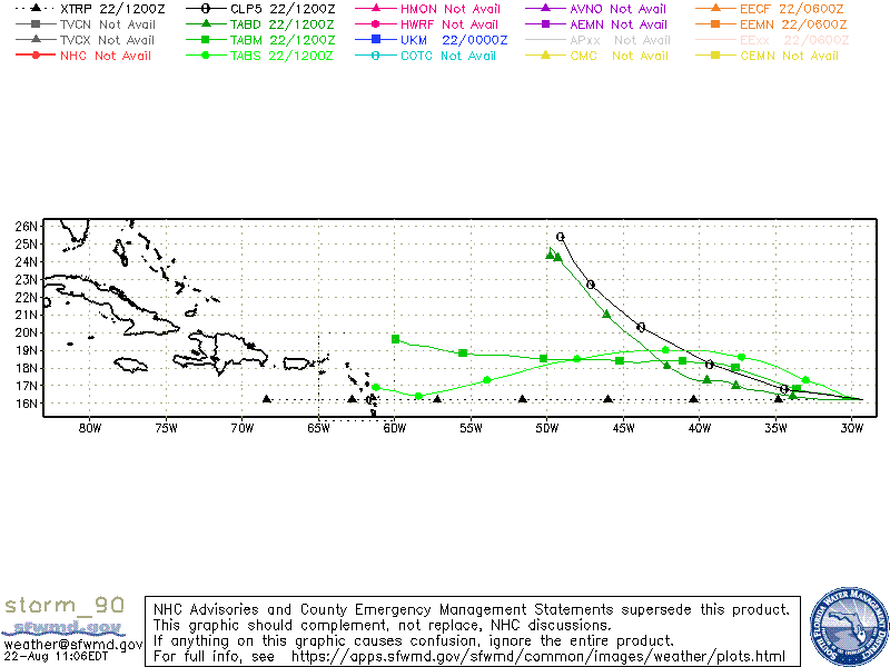
ATL: INVEST 90L - Models
Moderator: S2k Moderators
-
cycloneye

- Admin

- Posts: 139044
- Age: 67
- Joined: Thu Oct 10, 2002 10:54 am
- Location: San Juan, Puerto Rico
ATL: INVEST 90L - Models
Only model runs here.
0 likes
Visit the Caribbean-Central America Weather Thread where you can find at first post web cams,radars
and observations from Caribbean basin members Click Here
and observations from Caribbean basin members Click Here

-
cycloneye
- Admin
- Posts: 139044
- Age: 67
- Joined: Thu Oct 10, 2002 10:54 am
- Location: San Juan, Puerto Rico
Re: ATL: INVEST 90L - Models
* ATLANTIC 2021 SHIPS INTENSITY FORECAST *
* IR SAT DATA AVAILABLE, OHC AVAILABLE *
* INVEST AL902022 08/22/22 12 UTC *
TIME (HR) 0 6 12 18 24 36 48 60 72 84 96 108 120 132 144 156 168
V (KT) NO LAND 25 27 29 31 33 37 43 47 50 52 52 53 53 53 53 55 58
V (KT) LAND 25 27 29 31 33 37 43 47 50 52 52 53 53 53 53 55 58
V (KT) LGEM 25 25 26 27 28 30 33 37 41 43 43 41 39 36 33 31 29
Storm Type TROP TROP TROP TROP TROP TROP TROP TROP TROP TROP TROP TROP TROP TROP TROP TROP TROP
SHEAR (KT) 18 17 14 11 12 7 5 7 18 23 27 26 34 32 31 20 19
SHEAR ADJ (KT) 0 1 3 2 1 2 0 -2 3 0 1 6 0 0 -1 -3 -1
SHEAR DIR 74 84 92 84 65 68 6 268 266 239 250 234 244 239 253 247 246
SST (C) 26.9 26.4 26.1 26.3 26.7 26.2 26.3 26.3 26.4 26.8 27.1 27.5 27.7 27.9 28.4 28.7 28.9
POT. INT. (KT) 124 118 115 117 121 116 116 116 117 122 126 131 134 136 143 147 150
ADJ. POT. INT. 119 112 108 110 114 109 108 106 109 114 118 123 128 130 137 138 140
200 MB T (C) -53.2 -53.2 -53.3 -53.6 -53.7 -53.7 -54.2 -54.2 -54.6 -54.7 -55.0 -55.0 -55.3 -55.1 -55.1 -55.0 -55.1
200 MB VXT (C) 0.2 0.3 0.3 0.2 0.2 0.1 0.1 0.0 0.0 0.0 0.0 0.0 0.0 0.0 0.0 0.0 0.0
TH_E DEV (C) 4 4 4 4 4 5 5 5 5 6 7 8 8 9 9 9 8
700-500 MB RH 70 69 70 69 65 63 61 58 58 59 57 56 58 55 56 59 58
MODEL VTX (KT) 7 7 7 7 8 7 7 5 LOST LOST LOST LOST LOST LOST LOST LOST LOST
850 MB ENV VOR 47 46 54 63 63 74 55 62 59 86 64 68 61 38 29 25 18
200 MB DIV 4 6 5 20 31 23 7 -7 16 15 7 5 0 -14 5 36 32
700-850 TADV 1 1 1 2 2 1 3 3 0 6 4 4 7 -5 2 -3 0
LAND (KM) 1273 1402 1510 1617 1736 1954 2151 2062 1943 1816 1688 1588 1442 1244 1067 837 626
LAT (DEG N) 16.2 16.3 16.5 16.6 16.8 17.4 18.0 18.3 18.4 18.4 18.4 18.5 18.5 xx.x xx.x xx.x xx.x
LONG(DEG W) 29.3 30.5 31.5 32.5 33.6 35.6 37.6 39.2 41.1 43.0 45.2 47.5 50.2 xxx.x xxx.x xxx.x xxx.x
STM SPEED (KT) 12 11 10 10 10 10 9 8 9 10 11 11 13 12 12 10 10
HEAT CONTENT 5 1 0 2 9 1 2 3 4 9 12 23 29 29 24 30 34
FORECAST TRACK FROM TABM INITIAL HEADING/SPEED (DEG/KT):270/ 13 CX,CY: -12/ 0
T-12 MAX WIND: 25 PRESSURE OF STEERING LEVEL (MB): 523 (MEAN=620)
GOES IR BRIGHTNESS TEMP. STD DEV. 50-200 KM RAD: 12.2 (MEAN=14.5)
% GOES IR PIXELS WITH T < -20 C 50-200 KM RAD: 86.0 (MEAN=65.0)
PRELIM RI PROB (DV .GE. 35 KT IN 36 HR): 4.1
INDIVIDUAL CONTRIBUTIONS TO INTENSITY CHANGE
6 12 18 24 36 48 60 72 84 96 108 120 132 144 156 168
------------------------------------------------------------------------------
SAMPLE MEAN CHANGE 1. 2. 3. 4. 6. 8. 9. 10. 11. 12. 12. 13. 14. 15. 15. 16.
SST POTENTIAL 0. 0. 1. 1. 3. 7. 12. 16. 20. 23. 25. 27. 28. 29. 30. 30.
VERTICAL SHEAR MAG 1. 2. 3. 4. 5. 6. 7. 6. 4. 0. -3. -6. -10. -13. -14. -13.
VERTICAL SHEAR ADJ 0. -0. -0. -0. -0. -0. 0. 0. 0. 0. -0. -0. -0. 0. 0. 0.
VERTICAL SHEAR DIR 0. 1. 1. 1. 3. 4. 4. 3. 2. 1. 0. -1. -2. -2. -3. -3.
PERSISTENCE -0. -1. -1. -1. -0. -0. -0. -0. -0. 0. 0. 0. -0. -0. -1. -0.
200/250 MB TEMP. -0. -0. -1. -1. -1. -1. -1. -0. -0. 0. 0. 1. 2. 3. 4. 5.
THETA_E EXCESS -0. -1. -1. -1. -2. -2. -2. -2. -2. -1. -0. -0. 0. 0. 1. 1.
700-500 MB RH -0. -0. -1. -1. -2. -2. -3. -3. -3. -4. -4. -4. -4. -4. -4. -4.
MODEL VTX TENDENCY -0. -0. -0. -0. -1. -2. -5. -6. -7. -8. -9. -9. -10. -10. -10. -10.
850 MB ENV VORTICITY 0. 0. 0. 0. 1. 1. 1. 1. 2. 2. 2. 2. 2. 2. 2. 2.
200 MB DIVERGENCE -0. -0. -0. -1. -1. -1. -1. -1. -1. -1. -0. 0. 0. 1. 1. 2.
850-700 T ADVEC 0. -0. -0. -0. -0. -0. -0. -0. -0. -0. -0. -0. -0. -0. -0. -0.
ZONAL STORM MOTION -0. -0. 0. 0. 1. 1. 1. 1. 1. 2. 2. 2. 2. 2. 2. 2.
STEERING LEVEL PRES 0. 0. 0. 0. 1. 1. 0. 1. 1. 1. 2. 1. 1. 1. 1. 1.
DAYS FROM CLIM. PEAK 0. -0. -0. -0. 0. 0. 0. 0. 0. 0. 0. 0. 0. 0. 0. 0.
GOES PREDICTORS 1. 1. 2. 2. 1. 1. 0. 0. -0. -1. -1. -0. 1. 1. 2. 1.
OCEAN HEAT CONTENT 0. 0. 0. 0. 0. 0. -0. -0. -0. -0. -0. -0. -0. -0. -0. -0.
RI POTENTIAL -0. -1. -1. -1. -2. -2. -2. -1. -0. 1. 1. 2. 2. 2. 3. 3.
------------------------------------------------------------------------------
TOTAL CHANGE 2. 4. 6. 8. 12. 18. 22. 25. 27. 27. 28. 28. 28. 28. 30. 33.
CURRENT MAX WIND (KT): 25. LAT, LON: 16.2 29.3
** 2021 ATLANTIC RI INDEX AL902022 INVEST 08/22/22 12 UTC **
(SHIPS-RII PREDICTOR TABLE for 30 KT OR MORE MAXIMUM WIND INCREASE IN NEXT 24-h)
Predictor Value RI Predictor Range Scaled Value(0-1) % Contribution
12 HR PERSISTENCE (KT) : 0.0 -49.5 to 33.0 0.60 2.4
850-200 MB SHEAR (KT) : 14.2 30.1 to 2.3 0.57 1.1
HEAT CONTENT (KJ/CM2) : 3.4 0.0 to 151.8 0.02 0.0
STD DEV OF IR BR TEMP : 12.2 36.6 to 2.8 0.72 1.4
MAXIMUM WIND (KT) : 25.0 22.5 to 137.5 0.07 0.1
BL DRY-AIR FLUX (W/M2) : 102.2 895.4 to -55.0 0.83 1.3
2nd PC OF IR BR TEMP : -0.7 2.9 to -2.9 0.62 0.7
POT = MPI-VMAX (KT) : 87.7 28.3 to 146.3 0.50 0.4
D200 (10**7s-1) : 13.2 -29.7 to 185.9 0.20 0.1
%area of TPW <45 mm upshear : 0.0 100.0 to 0.0 1.00 0.1
SHIPS Prob RI for 20kt/ 12hr RI threshold= 4% is 0.7 times climatological mean ( 4.9%)
SHIPS Prob RI for 25kt/ 24hr RI threshold= 11% is 1.0 times climatological mean (10.9%)
SHIPS Prob RI for 30kt/ 24hr RI threshold= 8% is 1.1 times climatological mean ( 6.8%)
SHIPS Prob RI for 35kt/ 24hr RI threshold= 7% is 1.7 times climatological mean ( 3.9%)
SHIPS Prob RI for 40kt/ 24hr RI threshold= 0% is 0.0 times climatological mean ( 2.4%)
SHIPS Prob RI for 45kt/ 36hr RI threshold= 0% is 0.0 times climatological mean ( 4.6%)
SHIPS Prob RI for 55kt/ 48hr RI threshold= 0% is 0.0 times climatological mean ( 4.7%)
SHIPS Prob RI for 65kt/ 72hr RI threshold= 0% is 0.0 times climatological mean ( 5.3%)
Matrix of RI probabilities
------------------------------------------------------------------------------
RI (kt / h) | 20/12 | 25/24 | 30/24 | 35/24 | 40/24 | 45/36 | 55/48 |65/72
------------------------------------------------------------------------------
SHIPS-RII: 3.6% 10.8% 7.6% 6.8% 0.0% 0.0% 0.0% 0.0%
Logistic: 7.0% 17.5% 9.5% 4.5% 4.2% 13.8% 15.1% 4.4%
Bayesian: 0.8% 10.1% 1.5% 0.2% 0.1% 1.1% 1.7% 0.3%
Consensus: 3.8% 12.8% 6.2% 3.8% 1.4% 5.0% 5.6% 1.6%
DTOPS: 999.0% 999.0% 999.0% 999.0% 999.0% 999.0% 999.0% 999.0%
** PROBLTY OF AT LEAST 1 SCNDRY EYEWL FORMTN EVENT AL902022 INVEST 08/22/2022 12 UTC **
TIME(HR) 0-12 12-24(0-24) 24-36(0-36) 36-48(0-48)
CLIMO(%) 0 0( 0) 0( 0) 0( 0) <-- PROB BASED ON INTENSITY ONLY
PROB(%) 0 0( 0) 0( 0) 0( 0) <-- FULL MODEL PROB (RAN NORMALLY)
** DSHIPS INTENSITY FORECAST ADJUSTED RELATIVE TO ONSET OF ERC WEAKENING PHASE **
TIME (HR) 0 6 12 18 24 36 48 60 72 84 96 108 120 132 144 156 168
>24HR AGO (DSHIPS) 25 27 29 31 33 37 43 47 50 52 52 53 53 53 53 55 58
18HR AGO 25 24 26 28 30 34 40 44 47 49 49 50 50 50 50 52 55
12HR AGO 25 22 21 23 25 29 35 39 42 44 44 45 45 45 45 47 50
6HR AGO 25 19 16 15 17 21 27 31 34 36 36 37 37 37 37 39 42
NOW CURRENT INTENSITY < 83 KT
IN 6HR INTENSITY IN 6HR < 83 KT
IN 12HR INTENSITY IN 12HR < 83 KT
0 likes
Visit the Caribbean-Central America Weather Thread where you can find at first post web cams,radars
and observations from Caribbean basin members Click Here
and observations from Caribbean basin members Click Here
Re: ATL: INVEST 90L - Models
The medium BAM used to be the better deep tropics model. When did they change the name?
0 likes
-
Hurricaneman

- Category 5

- Posts: 7280
- Age: 43
- Joined: Tue Aug 31, 2004 3:24 pm
- Location: central florida
Re: ATL: INVEST 90L - Models
Looking at these models an evolution like Gloria in 1985 in that it really doesn’t get going until near the lesser Antilles.
If I remember right Gloria became a tropical cyclone at 40 to 45w but didn’t do much do to stable air and tutt shear until 60 to 65w
If I remember right Gloria became a tropical cyclone at 40 to 45w but didn’t do much do to stable air and tutt shear until 60 to 65w
0 likes
Re: ATL: INVEST 90L - Models
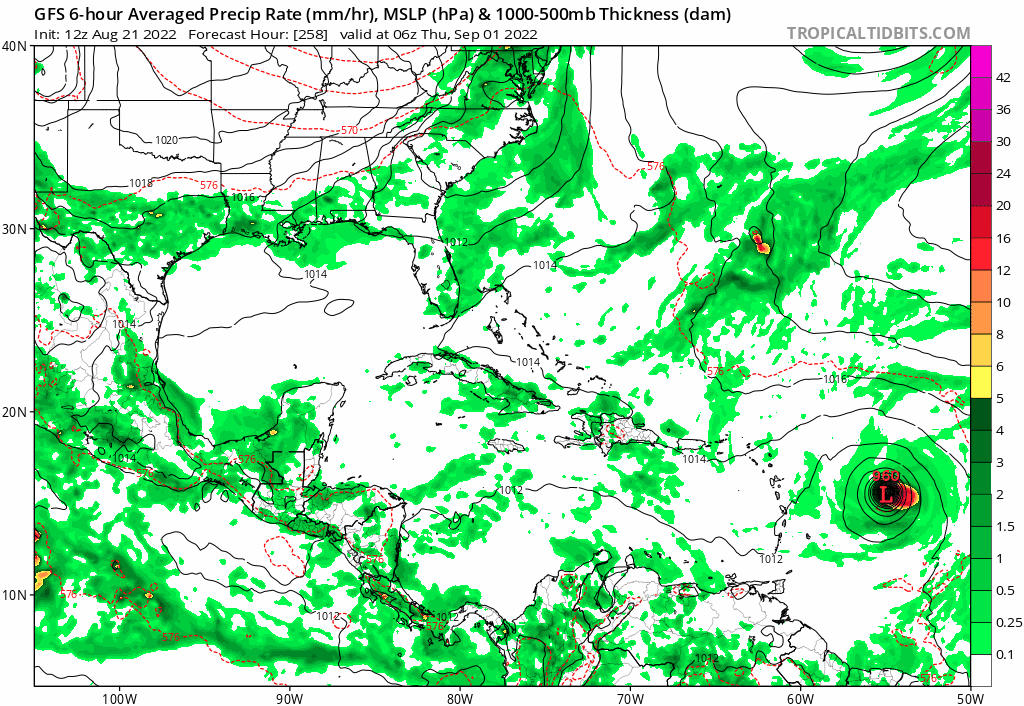
For the record, the GFS had this become a hurricane that gets into the western Atlantic basin as far back as the 0Z 8/15/22 run and a good number of GEFS members have had this as one over the last week or so. OTOH, the Euro had done little with it until the 12Z 8/19 run though it had one earlier run (8/12/22 12Z) with a weak but organizing surface low late.
The 0Z 8/15/22 GFS run had a 979 mb hurricane near 15N, 55W, at hour 318 and is from what has now become Invest 90L:

The 0Z 8/15/22 GFS run had a 979 mb hurricane near 15N, 55W, at hour 318 and is from what has now become Invest 90L:
Last edited by LarryWx on Mon Aug 22, 2022 11:25 am, edited 2 times in total.
3 likes
Personal Forecast Disclaimer:
The posts in this forum are NOT official forecasts and should not be used as such. They are just the opinion of the poster and may or may not be backed by sound meteorological data. They are NOT endorsed by any professional institution or storm2k.org. For official information, please refer to the NHC and NWS products.
The posts in this forum are NOT official forecasts and should not be used as such. They are just the opinion of the poster and may or may not be backed by sound meteorological data. They are NOT endorsed by any professional institution or storm2k.org. For official information, please refer to the NHC and NWS products.
-
Kingarabian

- S2K Supporter

- Posts: 15434
- Joined: Sat Aug 08, 2009 3:06 am
- Location: Honolulu, Hawaii
Re: ATL: INVEST 90L - Models
LarryWx wrote:For the record, the GFS had this become a hurricane that gets into the western Atlantic basin as far back as the 0Z 8/15/22 run and a good number of GEFS members have had this as one over the last week or so. OTOH, the Euro has done little with it though it had one earlier run (8/12/22 12Z) with a weak but organizing surface low late.
The 0Z 8/15/22 GFS run had a 979 mb hurricane near 15N, 55W, at hour 318 and is from what has now become Invest 90L:
https://i.imgur.com/qMgywNW.png
I believe 12z Euro finally developed this if I don't have my waves mixed up.
3 likes
RIP Kobe Bryant
Re: ATL: INVEST 90L - Models
Kingarabian wrote:LarryWx wrote:For the record, the GFS had this become a hurricane that gets into the western Atlantic basin as far back as the 0Z 8/15/22 run and a good number of GEFS members have had this as one over the last week or so. OTOH, the Euro has done little with it though it had one earlier run (8/12/22 12Z) with a weak but organizing surface low late.
The 0Z 8/15/22 GFS run had a 979 mb hurricane near 15N, 55W, at hour 318 and is from what has now become Invest 90L:
https://i.imgur.com/qMgywNW.png
I believe 12z Euro finally developed this if I don't have my waves mixed up.
You don't and I corrected what I said to this:
"OTOH, the Euro had done little with it until the 12Z 8/19 run though it had one earlier run (8/12/22 12Z) with a weak but organizing surface low late."
Today's 0Z Euro did have this at 992 mb just E of the Bahamas at day 10:

0 likes
Personal Forecast Disclaimer:
The posts in this forum are NOT official forecasts and should not be used as such. They are just the opinion of the poster and may or may not be backed by sound meteorological data. They are NOT endorsed by any professional institution or storm2k.org. For official information, please refer to the NHC and NWS products.
The posts in this forum are NOT official forecasts and should not be used as such. They are just the opinion of the poster and may or may not be backed by sound meteorological data. They are NOT endorsed by any professional institution or storm2k.org. For official information, please refer to the NHC and NWS products.
-
Blown Away

- S2K Supporter
- Posts: 9861
- Joined: Wed May 26, 2004 6:17 am
Re: ATL: INVEST 90L - Models
GFS trend is back showing 90L developing near Bahamas in @8 days.
0 likes
Hurricane Eye Experience: David 79, Irene 99, Frances 04, Jeanne 04, Wilma 05...
Hurricane Brush Experience: Andrew 92, Erin 95, Floyd 99, Matthew 16, Irma 17, Ian 22, Nicole 22…
Hurricane Brush Experience: Andrew 92, Erin 95, Floyd 99, Matthew 16, Irma 17, Ian 22, Nicole 22…
Re: ATL: INVEST 90L - Models
Blown Away wrote:[url]https://i.postimg.cc/mrCknB46/gfs-mslp-pcpn-watl-fh234-trend.gif [/url]
GFS trend is back showing 90L developing near Bahamas in @8 days.
Yeah this wave has been all over the map. I like these more convoluted scenarios - this one will be more tricky than usual I think
0 likes
-
gatorcane

- S2K Supporter
- Posts: 23499
- Age: 46
- Joined: Sun Mar 13, 2005 3:54 pm
- Location: Boca Raton, FL
Re: ATL: INVEST 90L - Models
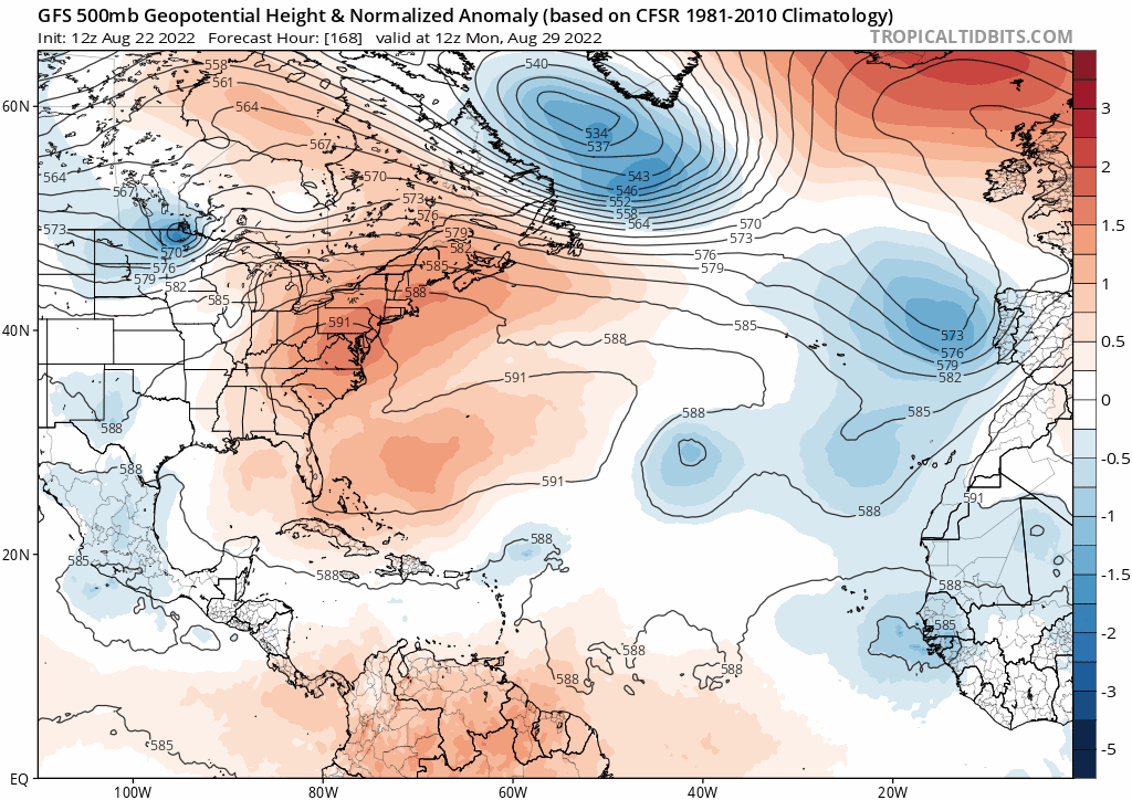
The global models are hinting at an anomalously strong trough over Eastern North America forming just beyond a week. Here is the 12Z GFS. It is still far out, so curious if the trough is as strong as we get closer:
0 likes
Re: ATL: INVEST 90L - Models
gatorcane wrote:The global models are hinting at an anomalously strong trough over Eastern North America forming just beyond a week. Here is the 12Z GFS. It is still far out, so curious if the trough is as strong as we get closer:
https://i.postimg.cc/T3LKqB9Z/gfs-z500a-Norm-atl-fh168-240.gif
Yes, should be interesting following the evolution of that trough, gator. A day or so ago that trough was not there, so worth paying attention to
0 likes
Re: ATL: INVEST 90L - Models
Blown Away wrote:[url]https://i.postimg.cc/mrCknB46/gfs-mslp-pcpn-watl-fh234-trend.gif [/url]
GFS trend is back showing 90L developing near Bahamas in @8 days.
This gets to as strong as a 982 mb hurricane on the 12Z GFS on Sept 3rd as it recurves well offshore the US after getting as far west as 70W (at 30N) on Sept 1st.
0 likes
Personal Forecast Disclaimer:
The posts in this forum are NOT official forecasts and should not be used as such. They are just the opinion of the poster and may or may not be backed by sound meteorological data. They are NOT endorsed by any professional institution or storm2k.org. For official information, please refer to the NHC and NWS products.
The posts in this forum are NOT official forecasts and should not be used as such. They are just the opinion of the poster and may or may not be backed by sound meteorological data. They are NOT endorsed by any professional institution or storm2k.org. For official information, please refer to the NHC and NWS products.
-
Blown Away
- S2K Supporter
- Posts: 9861
- Joined: Wed May 26, 2004 6:17 am
Re: ATL: INVEST 90L - Models
LarryWx wrote:Blown Away wrote:[url]https://i.postimg.cc/mrCknB46/gfs-mslp-pcpn-watl-fh234-trend.gif [/url]
GFS trend is back showing 90L developing near Bahamas in @8 days.
This gets to as strong as a 982 mb hurricane on the 12Z GFS on Sept 3rd as it recurves well offshore the US after getting as far west as 70W (at 30N) on Sept 1st.
12z GFS much faster than previous runs.
0 likes
Hurricane Eye Experience: David 79, Irene 99, Frances 04, Jeanne 04, Wilma 05...
Hurricane Brush Experience: Andrew 92, Erin 95, Floyd 99, Matthew 16, Irma 17, Ian 22, Nicole 22…
Hurricane Brush Experience: Andrew 92, Erin 95, Floyd 99, Matthew 16, Irma 17, Ian 22, Nicole 22…

Re: ATL: INVEST 90L - Models
So far it hasn’t developed on the Euro, but by 168hrs, it’s slightly north of PR.
0 likes
Irene '11 Sandy '12 Hermine '16 5/15/2018 Derecho Fay '20 Isaias '20 Elsa '21 Henri '21 Ida '21
I am only a meteorology enthusiast who knows a decent amount about tropical cyclones. Look to the professional mets, the NHC, or your local weather office for the best information.
I am only a meteorology enthusiast who knows a decent amount about tropical cyclones. Look to the professional mets, the NHC, or your local weather office for the best information.
-
AtlanticWind

- S2K Supporter
- Posts: 1805
- Age: 65
- Joined: Sun Aug 08, 2004 9:57 pm
- Location: Plantation,Fla
-
lsuhurricane
- Tropical Storm

- Posts: 208
- Joined: Tue Aug 15, 2017 2:53 pm
Re: ATL: INVEST 90L - Models
Euro ensembles showing a split to recurve vs. a due west track towards Cuba and South FL. Pretty even split.
WOuld think that this split displays the confidence (or lackthereof) of the trough eroding the ridge.
WOuld think that this split displays the confidence (or lackthereof) of the trough eroding the ridge.
0 likes
Re: ATL: INVEST 90L - Models
lsuhurricane wrote:Euro ensembles showing a split to recurve vs. a due west track towards Cuba and South FL. Pretty even split.
WOuld think that this split displays the confidence (or lackthereof) of the trough eroding the ridge.
Does the 12z EPS even show any development from its members?
0 likes
Re: ATL: INVEST 90L - Models
sma10 wrote:lsuhurricane wrote:Euro ensembles showing a split to recurve vs. a due west track towards Cuba and South FL. Pretty even split.
WOuld think that this split displays the confidence (or lackthereof) of the trough eroding the ridge.
Does the 12z EPS even show any development from its members?
Yes, 6 of ~51 get below 1,000 mb:
Strongest 974, 984, 987..so looks like 3 Hs vs 4 Hs on 0Z and 3 Hs on yesterday's 12Z
Last edited by LarryWx on Mon Aug 22, 2022 3:39 pm, edited 1 time in total.
0 likes
Personal Forecast Disclaimer:
The posts in this forum are NOT official forecasts and should not be used as such. They are just the opinion of the poster and may or may not be backed by sound meteorological data. They are NOT endorsed by any professional institution or storm2k.org. For official information, please refer to the NHC and NWS products.
The posts in this forum are NOT official forecasts and should not be used as such. They are just the opinion of the poster and may or may not be backed by sound meteorological data. They are NOT endorsed by any professional institution or storm2k.org. For official information, please refer to the NHC and NWS products.
Who is online
Users browsing this forum: No registered users and 22 guests