ATL: EARL - Models

Moderator: S2k Moderators

Message
Author
User avatar
aspen
Category 5
Category 5
Posts: 8056
Joined: Sat Oct 12, 2019 7:10 pm
Location: Connecticut, USA

Re: ATL: INVEST 91L - Models

#421 Postby aspen » Fri Sep 02, 2022 12:27 pm

SFLcane wrote:
aspen wrote:12z HWRF correctly initialized 91L with a tilted vortex. Maybe this run will be closer to the Euro/UK/CMC


No chance its already turning NW before 65w and intensifying.

The HWRF is up to early Monday on Tropical Tidbits, and so far while it is intensifying it hasn’t started recurving and the MLC/LLC only just snapped together. Are you looking at another site that’s ahead of TT?
1 likes   
Irene '11 Sandy '12 Hermine '16 5/15/2018 Derecho Fay '20 Isaias '20 Elsa '21 Henri '21 Ida '21

I am only a meteorology enthusiast who knows a decent amount about tropical cyclones. Look to the professional mets, the NHC, or your local weather office for the best information.

LarryWx
Category 5
Category 5
Posts: 5698
Joined: Sun Sep 07, 2003 2:04 pm
Location: GA

Re: ATL: INVEST 91L - Models

#422 Postby LarryWx » Fri Sep 02, 2022 12:28 pm
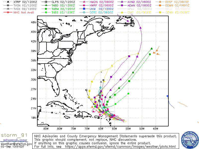
Kingarabian wrote:
LarryWx wrote:
Kingarabian wrote:12z UKMET continues to be the most west/south west compared to model guidance.

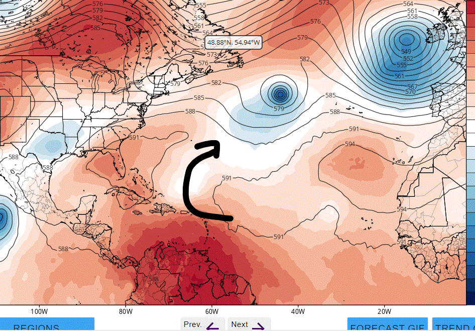
NEW TROPICAL CYCLONE FORECAST TO DEVELOP AFTER 132 HOURS
FORECAST POSITION AT T+132 : 22.5N 71.7W

LEAD CENTRAL MAXIMUM WIND
VERIFYING TIME TIME POSITION PRESSURE (MB) SPEED (KNOTS)
-------------- ---- -------- ------------- -------------
1200UTC 07.09.2022 132 22.5N 71.7W 1011 21
0000UTC 08.09.2022 144 22.4N 72.7W 1009 21


That's the old run (0Z).


Yup my bad.

21.7N 74.9W hour 144 on the 12z UKMET. Appears to be further SW.


The 12Z 132 hour UKMET position is 100 miles SW of the 0Z 144 and is moving slowly due west as opposed to moving NW. Of course, with it once again being a SW outlier by several hundred miles again, it could easily be off obviously.
Last edited by LarryWx on Fri Sep 02, 2022 12:39 pm, edited 1 time in total.
1 likes   
Personal Forecast Disclaimer:
The posts in this forum are NOT official forecasts and should not be used as such. They are just the opinion of the poster and may or may not be backed by sound meteorological data. They are NOT endorsed by any professional institution or storm2k.org. For official information, please refer to the NHC and NWS products.

User avatar
SFLcane
S2K Supporter
S2K Supporter
Posts: 9606
Age: 46
Joined: Sat Jun 05, 2010 1:44 pm
Location: Lake Worth Florida

Re: ATL: INVEST 91L - Models

#423 Postby SFLcane » Fri Sep 02, 2022 12:33 pm

LarryWx wrote:
Kingarabian wrote:
LarryWx wrote:
That's the old run (0Z).


Yup my bad.

21.7N 74.9W hour 144 on the 12z UKMET. Appears to be further SW.


The 12Z 132 hour UKMET position is 100 miles SW of the 0Z 144 and is moving slowly due west as opposed to NW at the end of the 12Z. Of course, with it once again being a SW outlier by several hundred miles again, it could easily be off obviously.


I think its a bias its always late to join the rest of the models.
0 likes   

User avatar
SFLcane
S2K Supporter
S2K Supporter
Posts: 9606
Age: 46
Joined: Sat Jun 05, 2010 1:44 pm
Location: Lake Worth Florida

Re: ATL: INVEST 91L - Models

#424 Postby SFLcane » Fri Sep 02, 2022 12:38 pm

aspen wrote:
SFLcane wrote:
aspen wrote:12z HWRF correctly initialized 91L with a tilted vortex. Maybe this run will be closer to the Euro/UK/CMC


No chance its already turning NW before 65w and intensifying.

The HWRF is up to early Monday on Tropical Tidbits, and so far while it is intensifying it hasn’t started recurving and the MLC/LLC only just snapped together. Are you looking at another site that’s ahead of TT?


Easy recurve its up near 24n already near 65w. I suspect the euro will recurve in the same fashion.
1 likes   

LarryWx
Category 5
Category 5
Posts: 5698
Joined: Sun Sep 07, 2003 2:04 pm
Location: GA

Re: ATL: INVEST 91L - Models

#425 Postby LarryWx » Fri Sep 02, 2022 12:47 pm

SFLcane wrote:
LarryWx wrote:
Kingarabian wrote:
Yup my bad.

21.7N 74.9W hour 144 on the 12z UKMET. Appears to be further SW.


The 12Z 132 hour UKMET position is 100 miles SW of the 0Z 144 and is moving slowly due west as opposed to NW at the end of the 12Z. Of course, with it once again being a SW outlier by several hundred miles again, it could easily be off obviously.


I think its a bias its always late to join the rest of the models.


Indeed, the UKMET sometimes is far to the left of the other models like it is now.  But if it isn't off and its very weak low stays intact, this is implying it could eventually (maybe not for 8-10+ days) become a Gulf problem.
2 likes   
Personal Forecast Disclaimer:
The posts in this forum are NOT official forecasts and should not be used as such. They are just the opinion of the poster and may or may not be backed by sound meteorological data. They are NOT endorsed by any professional institution or storm2k.org. For official information, please refer to the NHC and NWS products.

User avatar
SFLcane
S2K Supporter
S2K Supporter
Posts: 9606
Age: 46
Joined: Sat Jun 05, 2010 1:44 pm
Location: Lake Worth Florida

Re: ATL: INVEST 91L - Models

#426 Postby SFLcane » Fri Sep 02, 2022 12:53 pm

LarryWx wrote:
SFLcane wrote:
LarryWx wrote:
The 12Z 132 hour UKMET position is 100 miles SW of the 0Z 144 and is moving slowly due west as opposed to NW at the end of the 12Z. Of course, with it once again being a SW outlier by several hundred miles again, it could easily be off obviously.


I think its a bias its always late to join the rest of the models.


Indeed, the UKMET sometimes is far to the left of the other models like it is now.  But if it isn't off and its very weak low stays intact, this is implying it could eventually (maybe not for 8-10+ days) become a Gulf problem.


Na i just don't see that amount of ridging to drive this into the gulf. The more likely scenario is a stall followed by a recurve as the next trof swings down.
1 likes   

User avatar
Kingarabian
S2K Supporter
S2K Supporter
Posts: 15432
Joined: Sat Aug 08, 2009 3:06 am
Location: Honolulu, Hawaii

Re: ATL: INVEST 91L - Models

#427 Postby Kingarabian » Fri Sep 02, 2022 12:53 pm

Real time trends support the bearish models though.
3 likes   
RIP Kobe Bryant

User avatar
Kingarabian
S2K Supporter
S2K Supporter
Posts: 15432
Joined: Sat Aug 08, 2009 3:06 am
Location: Honolulu, Hawaii

Re: ATL: INVEST 91L - Models

#428 Postby Kingarabian » Fri Sep 02, 2022 12:56 pm

SFLcane wrote:
LarryWx wrote:
SFLcane wrote:
I think its a bias its always late to join the rest of the models.


Indeed, the UKMET sometimes is far to the left of the other models like it is now.  But if it isn't off and its very weak low stays intact, this is implying it could eventually (maybe not for 8-10+ days) become a Gulf problem.


Na i just don't see that amount of ridging to drive this into the gulf. The more likely scenario is a stall followed by a recurve as the next trof swings down.

How's it going to recurve safely if it continues to drift west? Not saying it'll strengthen significantly but it's getting so far west in these model runs that it may not clear land masses even if it recurves.
1 likes   
RIP Kobe Bryant

User avatar
SFLcane
S2K Supporter
S2K Supporter
Posts: 9606
Age: 46
Joined: Sat Jun 05, 2010 1:44 pm
Location: Lake Worth Florida

Re: ATL: INVEST 91L - Models

#429 Postby SFLcane » Fri Sep 02, 2022 12:58 pm

Kingarabian wrote:
SFLcane wrote:
LarryWx wrote:
Indeed, the UKMET sometimes is far to the left of the other models like it is now.  But if it isn't off and its very weak low stays intact, this is implying it could eventually (maybe not for 8-10+ days) become a Gulf problem.


Na i just don't see that amount of ridging to drive this into the gulf. The more likely scenario is a stall followed by a recurve as the next trof swings down.

How's it going to recurve safely if it continues to drift west? Not saying it'll strengthen significantly but it's getting so far west in these model runs that it may not clear land masses even if it recurves.


12z models take it almost due NW and out to sea.

Image
0 likes   

LarryWx
Category 5
Category 5
Posts: 5698
Joined: Sun Sep 07, 2003 2:04 pm
Location: GA

Re: ATL: INVEST 91L - Models

#430 Postby LarryWx » Fri Sep 02, 2022 1:01 pm

Kingarabian wrote:
SFLcane wrote:
LarryWx wrote:
Indeed, the UKMET sometimes is far to the left of the other models like it is now.  But if it isn't off and its very weak low stays intact, this is implying it could eventually (maybe not for 8-10+ days) become a Gulf problem.


Na i just don't see that amount of ridging to drive this into the gulf. The more likely scenario is a stall followed by a recurve as the next trof swings down.

How's it going to recurve safely if it continues to drift west? Not saying it'll strengthen significantly but it's getting so far west in these model runs that it may not clear land masses even if it recurves.


Agreed. IF there is a surface low near Cuba in still early September moving due west, climo says good luck on getting it to recurve sharply enough to miss the US. It may be very weak, but who the heck knows and that's beside the point. I'm talking about steering.
1 likes   
Personal Forecast Disclaimer:
The posts in this forum are NOT official forecasts and should not be used as such. They are just the opinion of the poster and may or may not be backed by sound meteorological data. They are NOT endorsed by any professional institution or storm2k.org. For official information, please refer to the NHC and NWS products.

LarryWx
Category 5
Category 5
Posts: 5698
Joined: Sun Sep 07, 2003 2:04 pm
Location: GA

Re: ATL: INVEST 91L - Models

#431 Postby LarryWx » Fri Sep 02, 2022 1:05 pm

SFLcane wrote:
Kingarabian wrote:
SFLcane wrote:
Na i just don't see that amount of ridging to drive this into the gulf. The more likely scenario is a stall followed by a recurve as the next trof swings down.

How's it going to recurve safely if it continues to drift west? Not saying it'll strengthen significantly but it's getting so far west in these model runs that it may not clear land masses even if it recurves.


12z models take it almost due NW and out to sea.

https://i.postimg.cc/wTjf9yyY/storm-91.gif


But not the 12Z UKMET, which is moving due west near Cuba albeit only as a very weak low as opposed to a TC (and thus not on your map).
Last edited by LarryWx on Fri Sep 02, 2022 1:05 pm, edited 2 times in total.
0 likes   
Personal Forecast Disclaimer:
The posts in this forum are NOT official forecasts and should not be used as such. They are just the opinion of the poster and may or may not be backed by sound meteorological data. They are NOT endorsed by any professional institution or storm2k.org. For official information, please refer to the NHC and NWS products.

User avatar
DestinHurricane
Category 4
Category 4
Posts: 930
Joined: Tue May 01, 2018 8:05 am
Location: Columbus, OH... need to get back in the action

Re: ATL: INVEST 91L - Models

#432 Postby DestinHurricane » Fri Sep 02, 2022 1:05 pm

It better start gaining some latitude if the GFS is to verify
0 likes   
Destin/Santa Rosa Beach, Florida: Ivan 2004, Dennis 2005, Michael 2018, Sally 2020

Fort Lauderdale, Florida Eta 2020, Many future storms!

THE Ohio State University: :cold:

tolakram
Admin
Admin
Posts: 19165
Age: 60
Joined: Sun Aug 27, 2006 8:23 pm
Location: Florence, KY (name is Mark)

Re: ATL: INVEST 91L - Models

#433 Postby tolakram » Fri Sep 02, 2022 1:06 pm

EC-FAST a little better organized

Image
0 likes   
M a r k
- - - - -
Join us in chat: Storm2K Chatroom Invite. Android and IOS apps also available.

The posts in this forum are NOT official forecasts and should not be used as such. Posts are NOT endorsed by any professional institution or STORM2K.org. For official information and forecasts, please refer to NHC and NWS products.

tolakram
Admin
Admin
Posts: 19165
Age: 60
Joined: Sun Aug 27, 2006 8:23 pm
Location: Florence, KY (name is Mark)

Re: ATL: INVEST 91L - Models

#434 Postby tolakram » Fri Sep 02, 2022 1:07 pm

or not

Image
0 likes   
M a r k
- - - - -
Join us in chat: Storm2K Chatroom Invite. Android and IOS apps also available.

The posts in this forum are NOT official forecasts and should not be used as such. Posts are NOT endorsed by any professional institution or STORM2K.org. For official information and forecasts, please refer to NHC and NWS products.

User avatar
SFLcane
S2K Supporter
S2K Supporter
Posts: 9606
Age: 46
Joined: Sat Jun 05, 2010 1:44 pm
Location: Lake Worth Florida

Re: ATL: INVEST 91L - Models

#435 Postby SFLcane » Fri Sep 02, 2022 1:15 pm

Euro with an easy recurve near 70w.

Image
2 likes   

LarryWx
Category 5
Category 5
Posts: 5698
Joined: Sun Sep 07, 2003 2:04 pm
Location: GA

Re: ATL: INVEST 91L - Models

#436 Postby LarryWx » Fri Sep 02, 2022 1:19 pm

SFLcane wrote:Euro with an easy recurve near 70w.


Indeed, which means the 12Z UKMET moving due west way on down near Cuba is an extreme SW outlier and thus likely wrong like usually is the case when it is a far SW outlier. But if it were to somehow not be wrong, then obviously everything changes.
0 likes   
Personal Forecast Disclaimer:
The posts in this forum are NOT official forecasts and should not be used as such. They are just the opinion of the poster and may or may not be backed by sound meteorological data. They are NOT endorsed by any professional institution or storm2k.org. For official information, please refer to the NHC and NWS products.

User avatar
SFLcane
S2K Supporter
S2K Supporter
Posts: 9606
Age: 46
Joined: Sat Jun 05, 2010 1:44 pm
Location: Lake Worth Florida

Re: ATL: INVEST 91L - Models

#437 Postby SFLcane » Fri Sep 02, 2022 1:21 pm

LarryWx wrote:
SFLcane wrote:Euro with an easy recurve near 70w.


Indeed, which means the 12Z UKMET moving due west way on down near Cuba is an extreme SW outlier and thus likely wrong like usually is the case when it is a far SW outlier. But if it were to somehow not be wrong, then obviously everything changes.


It is wrong we have been here before. Its always late to join the rest of the models. Bring on the holidays i am already over this season or the lack of lol. Huricane almost near 45n. Just dumb :roll:
2 likes   

User avatar
NDG
S2K Supporter
S2K Supporter
Posts: 14933
Joined: Sun Jul 09, 2006 10:14 pm
Location: Orlando, FL

Re: ATL: INVEST 91L - Models

#438 Postby NDG » Fri Sep 02, 2022 1:42 pm

Wow, the Euro is folding to the GFS in the pattern, didn't see that coming :D
1 likes   

tolakram
Admin
Admin
Posts: 19165
Age: 60
Joined: Sun Aug 27, 2006 8:23 pm
Location: Florence, KY (name is Mark)

Re: ATL: INVEST 91L - Models

#439 Postby tolakram » Fri Sep 02, 2022 1:48 pm

Pretty ugly

Image
1 likes   
M a r k
- - - - -
Join us in chat: Storm2K Chatroom Invite. Android and IOS apps also available.

The posts in this forum are NOT official forecasts and should not be used as such. Posts are NOT endorsed by any professional institution or STORM2K.org. For official information and forecasts, please refer to NHC and NWS products.

User avatar
Kingarabian
S2K Supporter
S2K Supporter
Posts: 15432
Joined: Sat Aug 08, 2009 3:06 am
Location: Honolulu, Hawaii

Re: ATL: INVEST 91L - Models

#440 Postby Kingarabian » Fri Sep 02, 2022 1:59 pm

NDG wrote:Wow, the Euro is folding to the GFS in the pattern, didn't see that coming :D

All of a sudden it has a strong trough at hour 144-168.

This recurving that weak will be the stamp on the state of this season lol.
0 likes   
RIP Kobe Bryant


Return to “2022”

Who is online

Users browsing this forum: No registered users and 25 guests