ATL: EARL - Models

Moderator: S2k Moderators

Message
Author
User avatar
NotSparta
Professional-Met
Professional-Met
Posts: 1649
Age: 22
Joined: Fri Aug 18, 2017 8:24 am
Location: Naples, FL
Contact:

Re: ATL: INVEST 91L - Models

#21 Postby NotSparta » Sat Aug 27, 2022 11:48 pm

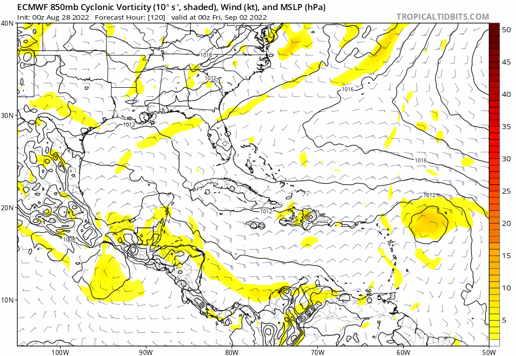
Hurricaneman wrote:The main problem with the 0zGFS is that it seems to be sprouting a random vortex on the north side of the wave near the islands which could be throwing the run off, let’s see if it models continue to show this or if it’s erroneous . Will have to watch the next few days


Also probably a little shear from the hurricane in the Gulf
0 likes   
This post was probably an opinion of mine, and in no way is official. Please refer to http://www.hurricanes.gov for official tropical analysis and advisories.

My website, with lots of tropical wx graphics, including satellite and recon: http://cyclonicwx.com

User avatar
SouthFLTropics
Category 5
Category 5
Posts: 4156
Age: 48
Joined: Thu Aug 14, 2003 8:04 am
Location: Port St. Lucie, Florida

Re: ATL: INVEST 91L - Models

#22 Postby SouthFLTropics » Sat Aug 27, 2022 11:53 pm

GFS ensembles don’t seem to impressed either.
0 likes   
Fourth Generation Floridian...With lots of storm knowledge passed down from my elders...

Personal Storm History: David 79, Andrew 92, Erin 95, Floyd 99, Irene 99, Frances 04, Jeanne 04, Wilma 05, Matthew 16, Irma 17

User avatar
Iceresistance
Category 5
Category 5
Posts: 8915
Age: 20
Joined: Sat Oct 10, 2020 9:45 am
Location: Tecumseh, OK/Norman, OK

Re: ATL: INVEST 91L - Models

#23 Postby Iceresistance » Sun Aug 28, 2022 12:00 am


Looks like the ICON has caved in with the 12z NAVGEM
0 likes   
Bill 2015 & Beta 2020

Winter 2020-2021 :cold:

All observations are in Tecumseh, OK unless otherwise noted.

Winter posts are focused mainly for Oklahoma & Texas.

Take any of my forecasts with a grain of salt, refer to the NWS, SPC, and NHC for official information

Never say Never with weather! Because ANYTHING is possible!

User avatar
skyline385
Category 5
Category 5
Posts: 2444
Age: 33
Joined: Wed Aug 26, 2020 11:15 pm
Location: Palm Beach County FL

Re: ATL: INVEST 91L - Models

#24 Postby skyline385 » Sun Aug 28, 2022 1:22 am

Weaker 0Z Euro as well, its a disorganized mess right near the LA.

So for today's 0Z cycle, ECMWF, CMC and ICON have all trended weaker.

Image
0 likes   

User avatar
AtlanticWind
S2K Supporter
S2K Supporter
Posts: 1805
Age: 65
Joined: Sun Aug 08, 2004 9:57 pm
Location: Plantation,Fla

Re: ATL: INVEST 91L - Models

#25 Postby AtlanticWind » Sun Aug 28, 2022 1:41 am

Weaker on Euro,but looks like less of an escape hatch to the north.

Models are not reliably for strengh that far out and am not liking the setup for us in Florida
at this point.
But lots of time ...
0 likes   

User avatar
skyline385
Category 5
Category 5
Posts: 2444
Age: 33
Joined: Wed Aug 26, 2020 11:15 pm
Location: Palm Beach County FL

Re: ATL: INVEST 91L - Models

#26 Postby skyline385 » Sun Aug 28, 2022 1:50 am

AtlanticWind wrote:Weaker on Euro,but looks like less of an escape hatch to the north.

Models are not reliably for strengh that far out and am not liking the setup for us in Florida
at this point.
But lots of time ...


Models are not reliable for anything 10 days out except showing a possible scenario, that is why I was talking about the trend.

When all models suddenly start trending weaker, then at the very least you know that the wave is not having a good time right now.
1 likes   

User avatar
AtlanticWind
S2K Supporter
S2K Supporter
Posts: 1805
Age: 65
Joined: Sun Aug 08, 2004 9:57 pm
Location: Plantation,Fla

Re: ATL: INVEST 91L - Models

#27 Postby AtlanticWind » Sun Aug 28, 2022 1:54 am

skyline385 wrote:
AtlanticWind wrote:Weaker on Euro,but looks like less of an escape hatch to the north.

Models are not reliably for strengh that far out and am not liking the setup for us in Florida
at this point.
But lots of time ...


Models are not reliable for anything 10 days out except showing a possible scenario, that is why I was talking about the trend.

When all models suddenly start trending weaker, then at the very least you know that the wave is not having a good time right now.


No model really had the wave doing much right now or in next 3 to 4 days , but the Euro showed
conditions in 5 + days being good for devolpment but backed off that tonight.
Still a long ways out for models .
3 likes   

User avatar
AtlanticWind
S2K Supporter
S2K Supporter
Posts: 1805
Age: 65
Joined: Sun Aug 08, 2004 9:57 pm
Location: Plantation,Fla

Re: ATL: INVEST 91L - Models

#28 Postby AtlanticWind » Sun Aug 28, 2022 3:09 am

00z Euro ensembles still a strong signal for devolpment.
0 likes   

User avatar
AtlanticWind
S2K Supporter
S2K Supporter
Posts: 1805
Age: 65
Joined: Sun Aug 08, 2004 9:57 pm
Location: Plantation,Fla

Re: ATL: INVEST 91L - Models

#29 Postby AtlanticWind » Sun Aug 28, 2022 3:24 am

HMON and HWRF basically show no development thru the 5 days
0 likes   

User avatar
Jr0d
S2K Supporter
S2K Supporter
Posts: 1174
Joined: Tue Aug 27, 2019 10:52 am
Location: Cayo Hueso

Re: ATL: INVEST 91L - Models

#30 Postby Jr0d » Sun Aug 28, 2022 4:38 am

Iceresistance wrote:


Looks like the ICON has caved in with the 12z NAVGEM


Dont like the High over the Carolinas that pops up at the end of the run, the EURO is showing it also. Worried it block a recurve before it reaches the CONUS.

The GFS has performed horribly this past month, it will likely cave before too long. Once it drops the phantom storm it will pick up on this one.
0 likes   

User avatar
cycloneye
Admin
Admin
Posts: 139089
Age: 67
Joined: Thu Oct 10, 2002 10:54 am
Location: San Juan, Puerto Rico

Re: ATL: INVEST 91L - Models

#31 Postby cycloneye » Sun Aug 28, 2022 5:35 am

Jr0d wrote:
Iceresistance wrote:


Looks like the ICON has caved in with the 12z NAVGEM


Dont like the High over the Carolinas that pops up at the end of the run, the EURO is showing it also. Worried it block a recurve before it reaches the CONUS.

The GFS has performed horribly this past month, it will likely cave before too long. Once it drops the phantom storm it will pick up on this one.


On 06z it has both strong.
0 likes   
Visit the Caribbean-Central America Weather Thread where you can find at first post web cams,radars
and observations from Caribbean basin members Click Here

User avatar
SFLcane
S2K Supporter
S2K Supporter
Posts: 9606
Age: 46
Joined: Sat Jun 05, 2010 1:44 pm
Location: Lake Worth Florida

Re: ATL: INVEST 91L - Models

#32 Postby SFLcane » Sun Aug 28, 2022 5:54 am

Image
0 likes   

User avatar
ronjon
Category 5
Category 5
Posts: 4671
Joined: Fri Aug 19, 2005 5:17 pm
Location: Hernando Beach, FL

Re: ATL: INVEST 91L - Models

#33 Postby ronjon » Sun Aug 28, 2022 5:55 am

This thing stays weak not good for the SE US. It won't gain much latitude prior to reaching the Bahamas and we all know how storms can rapidly intensify there.
4 likes   

User avatar
cycloneye
Admin
Admin
Posts: 139089
Age: 67
Joined: Thu Oct 10, 2002 10:54 am
Location: San Juan, Puerto Rico

Re: ATL: INVEST 91L - Models

#34 Postby cycloneye » Sun Aug 28, 2022 5:56 am

06Z GFS makes a very strong comeback and recurves towards Bermuda.

Image
0 likes   
Visit the Caribbean-Central America Weather Thread where you can find at first post web cams,radars
and observations from Caribbean basin members Click Here

jlauderdal
S2K Supporter
S2K Supporter
Posts: 6771
Joined: Wed May 19, 2004 5:46 am
Location: NE Fort Lauderdale
Contact:

Re: ATL: INVEST 91L - Models

#35 Postby jlauderdal » Sun Aug 28, 2022 5:58 am


weakening on approach but more importantly, is the ridge
0 likes   

jlauderdal
S2K Supporter
S2K Supporter
Posts: 6771
Joined: Wed May 19, 2004 5:46 am
Location: NE Fort Lauderdale
Contact:

Re: ATL: INVEST 91L - Models

#36 Postby jlauderdal » Sun Aug 28, 2022 5:59 am

cycloneye wrote:06Z GFS makes a very strong comeback and recurves towards Bermuda.

https://i.imgur.com/eSeIHMK.gif


recurves right into a ridge; we have seen that before with the GFS

GFS showing more intensity than the euro thus the more northern solution but certainly not intense enough to displace the ridge on its own. Very dangerous part of the basin, this is where hurricanes go for major intensification, euro weakens it on approach even though the environment looks good.
0 likes   

User avatar
Blown Away
S2K Supporter
S2K Supporter
Posts: 9863
Joined: Wed May 26, 2004 6:17 am

Re: ATL: INVEST 91L - Models

#37 Postby Blown Away » Sun Aug 28, 2022 6:38 am

Image
00z ECMWF - W shift.
0 likes   
Hurricane Eye Experience: David 79, Irene 99, Frances 04, Jeanne 04, Wilma 05...
Hurricane Brush Experience: Andrew 92, Erin 95, Floyd 99, Matthew 16, Irma 17, Ian 22, Nicole 22…

tolakram
Admin
Admin
Posts: 19165
Age: 60
Joined: Sun Aug 27, 2006 8:23 pm
Location: Florence, KY (name is Mark)

Re: ATL: INVEST 91L - Models

#38 Postby tolakram » Sun Aug 28, 2022 6:39 am

0Z Euro showing a really unfavorable upper air environment, lots of shear. Current map shows how shear looks at the moment, and it's pretty rough.

Image

Image
0 likes   
M a r k
- - - - -
Join us in chat: Storm2K Chatroom Invite. Android and IOS apps also available.

The posts in this forum are NOT official forecasts and should not be used as such. Posts are NOT endorsed by any professional institution or STORM2K.org. For official information and forecasts, please refer to NHC and NWS products.

User avatar
Blown Away
S2K Supporter
S2K Supporter
Posts: 9863
Joined: Wed May 26, 2004 6:17 am

Re: ATL: INVEST 91L - Models

#39 Postby Blown Away » Sun Aug 28, 2022 6:40 am

Image

00z ECENS
Last edited by tolakram on Sun Aug 28, 2022 9:49 am, edited 1 time in total.
Reason: changed to IMG link only to remove ad link
0 likes   
Hurricane Eye Experience: David 79, Irene 99, Frances 04, Jeanne 04, Wilma 05...
Hurricane Brush Experience: Andrew 92, Erin 95, Floyd 99, Matthew 16, Irma 17, Ian 22, Nicole 22…

jlauderdal
S2K Supporter
S2K Supporter
Posts: 6771
Joined: Wed May 19, 2004 5:46 am
Location: NE Fort Lauderdale
Contact:

Re: ATL: INVEST 91L - Models

#40 Postby jlauderdal » Sun Aug 28, 2022 6:47 am

tolakram wrote:0Z Euro showing a really unfavorable upper air environment, lots of shear. Current map shows how shear looks at the moment, and it's pretty rough.

https://i.imgur.com/UtGKiGe.png

https://i.imgur.com/76tcqCz.png


meanwhile, development chances keep increasing, nhc likes it 30/70
0 likes   


Return to “2022”

Who is online

Users browsing this forum: No registered users and 72 guests