ATL: EARL - Models

Moderator: S2k Moderators

Message
Author
User avatar
skyline385
Category 5
Category 5
Posts: 2500
Age: 33
Joined: Wed Aug 26, 2020 11:15 pm
Location: Houston TX

Re: ATL: INVEST 91L - Models

#101 Postby skyline385 » Sun Aug 28, 2022 2:27 pm

toad strangler wrote:
AutoPenalti wrote:It’s pretty hard to get a SFL hit here if steering collapses, but the trend is worrying.

Jesus, the Bahamas with Dorian 2.0


Agree. If steering collapses it will find any little pinhole weakness possible and start N. That’s what we’ll organized TC’s do.


The problem will be its location when the collapse happens. Its already getting plenty close to SFL and if it collapses over it, then it will most likely be a worst case scenario.
3 likes   

lsuhurricane
Tropical Storm
Tropical Storm
Posts: 208
Joined: Tue Aug 15, 2017 2:53 pm

Re: ATL: INVEST 91L - Models

#102 Postby lsuhurricane » Sun Aug 28, 2022 2:28 pm

Euro Ensembles strongly favor a recurve.
3 likes   

User avatar
gatorcane
S2K Supporter
S2K Supporter
Posts: 23499
Age: 46
Joined: Sun Mar 13, 2005 3:54 pm
Location: Boca Raton, FL

Re: ATL: INVEST 91L - Models

#103 Postby gatorcane » Sun Aug 28, 2022 2:29 pm

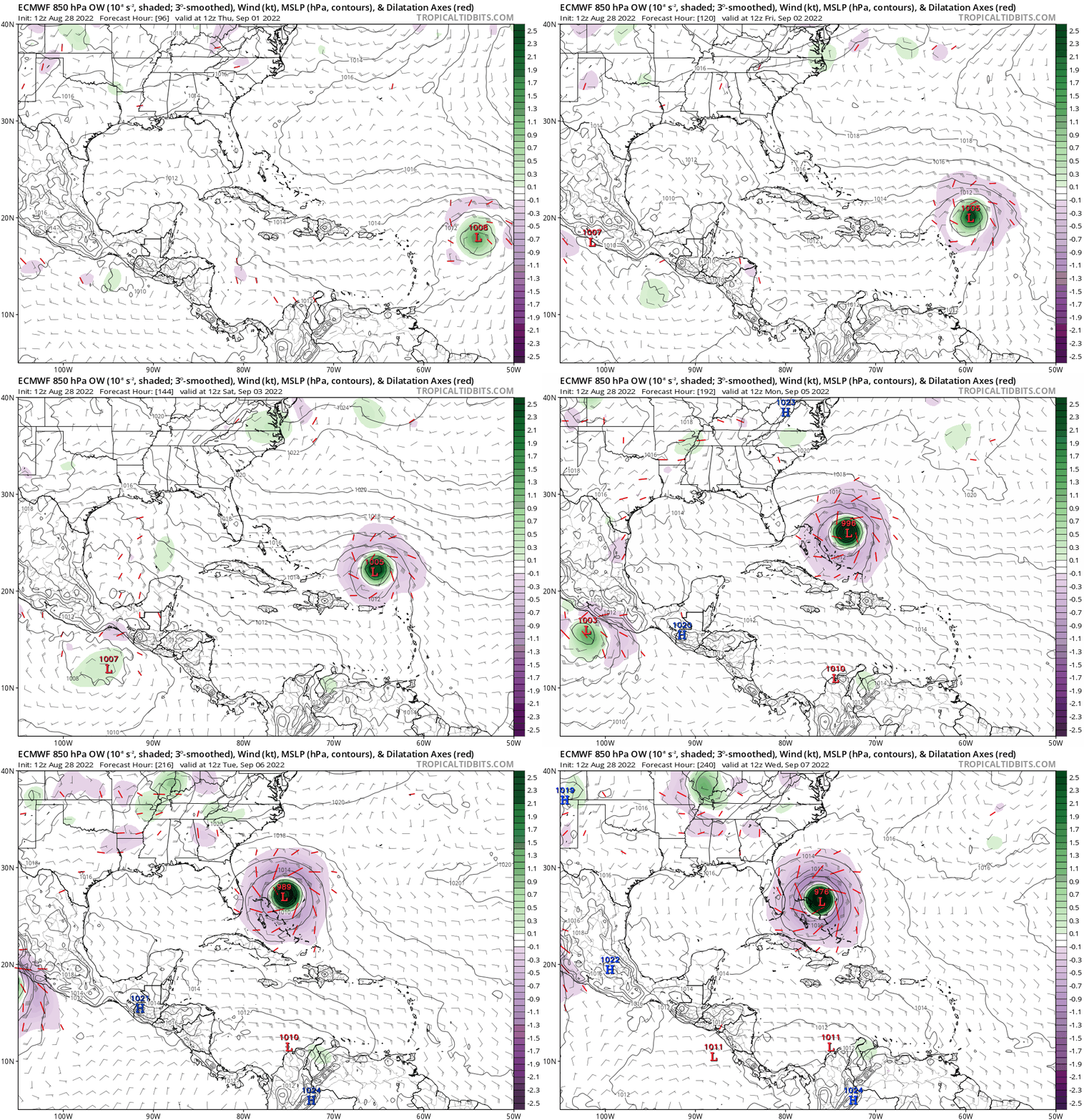
End of 12z ECMWF looks like the start of a counter-clockwise loop, had the run gone out farther thinking it would start heading northeast. That is one timely ridge over Florida to “save the day” if it verifies, haven’t really seen that type of ridge much this summer.
3 likes   

User avatar
tarheelprogrammer
S2K Supporter
S2K Supporter
Posts: 1793
Joined: Mon Mar 28, 2016 9:25 pm
Location: Raleigh, NC area (Garner, NC)

Re: ATL: INVEST 91L - Models

#104 Postby tarheelprogrammer » Sun Aug 28, 2022 2:35 pm

gatorcane wrote:End of 12z ECMWF looks like the start of a counter-clockwise loop, had the run gone out farther thinking it would start heading northeast, that is what timely ridge over Florida to “save the day” if it verifies, haven’t really seen that type of ridge much this summer.


Timely to say the least but the most likely outcome in most scenarios like this. Still time to change but we have all seen this song and dance before.
1 likes   
My posts are not official forecasts. They are just my opinion and may or may not be backed by sound meteorological data. They are NOT endorsed by any professional institution or storm2k.org. For official information, please refer to the NHC and NWS products.

User avatar
Nimbus
Category 5
Category 5
Posts: 4928
Joined: Mon Jul 19, 2004 10:54 am

Re: ATL: INVEST 91L - Models

#105 Postby Nimbus » Sun Aug 28, 2022 2:36 pm

AutoPenalti wrote:It’s pretty hard to get a SFL hit here if steering collapses, but the trend is worrying.

Jesus, the Bahamas with Dorian 2.0


At 25N these storms recurve on their own unless they are trapped under the east side of a ridge.
But usually we see a front or at least a short wave move off the east coast periodically so I'm not looking for this yet.
0 likes   

User avatar
Iceresistance
Category 5
Category 5
Posts: 8925
Age: 20
Joined: Sat Oct 10, 2020 9:45 am
Location: Tecumseh, OK/Norman, OK

Re: ATL: INVEST 91L - Models

#106 Postby Iceresistance » Sun Aug 28, 2022 2:41 pm

AutoPenalti wrote:It’s pretty hard to get a SFL hit here if steering collapses, but the trend is worrying.

Jesus, the Bahamas with Dorian 2.0

We're also at the letter D too. This may be the same storm track but with a different D, literally! :eek:
1 likes   
Bill 2015 & Beta 2020

Winter 2020-2021 :cold:

All observations are in Tecumseh, OK unless otherwise noted.

Winter posts are focused mainly for Oklahoma & Texas.

Take any of my forecasts with a grain of salt, refer to the NWS, SPC, and NHC for official information

Never say Never with weather! Because ANYTHING is possible!

User avatar
toad strangler
S2K Supporter
S2K Supporter
Posts: 4170
Joined: Sun Jul 28, 2013 3:09 pm
Location: Earth
Contact:

Re: ATL: INVEST 91L - Models

#107 Postby toad strangler » Sun Aug 28, 2022 2:46 pm

skyline385 wrote:
toad strangler wrote:
AutoPenalti wrote:It’s pretty hard to get a SFL hit here if steering collapses, but the trend is worrying.

Jesus, the Bahamas with Dorian 2.0


Agree. If steering collapses it will find any little pinhole weakness possible and start N. That’s what we’ll organized TC’s do.


The problem will be its location when the collapse happens. Its already getting plenty close to SFL and if it collapses over it, then it will most likely be a worst case scenario.


Ya, location means everything as the Bahama’s would attest to. I just don’t believe any steering past 3-5 days and that’s stretching it. I’ll never forget Matthew. Models kept shifting W for days and days after showing many runs of a safe re-curve.

Bottoms line is nobody on this planet knows anything beyond the near term. Just have to track it! With the understanding that a recurve away from the SE CONUS would be textbook climatology.
1 likes   

User avatar
skyline385
Category 5
Category 5
Posts: 2500
Age: 33
Joined: Wed Aug 26, 2020 11:15 pm
Location: Houston TX

Re: ATL: INVEST 91L - Models

#108 Postby skyline385 » Sun Aug 28, 2022 2:50 pm

0 likes   

User avatar
Spacecoast
Category 2
Category 2
Posts: 687
Joined: Thu Aug 31, 2017 2:03 pm

Re: ATL: INVEST 91L - Models

#109 Postby Spacecoast » Sun Aug 28, 2022 2:52 pm

lsuhurricane wrote:Euro Ensembles strongly favor a recurve.


Image
3 likes   

User avatar
Meteorcane
Category 2
Category 2
Posts: 541
Joined: Thu Jul 21, 2011 6:49 am
Location: North Platte Nebraska

Re: ATL: INVEST 91L - Models

#110 Postby Meteorcane » Sun Aug 28, 2022 2:55 pm

Some good news for CONUS interests is that the EPS mean 500mb pattern still supports a general SW shunting of the western Atlantic ridge in the long term with below normal heights then favored in the western Atlantic (which would favor a weakness developing allowing the system to go north/northeast). This setup results in the bulk of the EPS cyclone tracks recurving OTS east of the CONUS. That being said even using ensemble averaged fields it is difficult to have high confidence in the synoptic setup beyond about 6-7 days so it will bear watching in the meantime.

Image
Last edited by Meteorcane on Sun Aug 28, 2022 2:58 pm, edited 1 time in total.
1 likes   

User avatar
SFLcane
S2K Supporter
S2K Supporter
Posts: 9617
Age: 46
Joined: Sat Jun 05, 2010 1:44 pm
Location: Lake Worth Florida

Re: ATL: INVEST 91L - Models

#111 Postby SFLcane » Sun Aug 28, 2022 2:57 pm

Image
0 likes   

User avatar
SFLcane
S2K Supporter
S2K Supporter
Posts: 9617
Age: 46
Joined: Sat Jun 05, 2010 1:44 pm
Location: Lake Worth Florida

Re: ATL: INVEST 91L - Models

#112 Postby SFLcane » Sun Aug 28, 2022 3:00 pm

EPS control run is over South Florida and stalls as a rather potent hurricane.
Last edited by SFLcane on Sun Aug 28, 2022 3:03 pm, edited 1 time in total.
0 likes   

User avatar
skyline385
Category 5
Category 5
Posts: 2500
Age: 33
Joined: Wed Aug 26, 2020 11:15 pm
Location: Houston TX

Re: RE: Re: ATL: INVEST 91L - Models

#113 Postby skyline385 » Sun Aug 28, 2022 3:02 pm

toad strangler wrote:
skyline385 wrote:
toad strangler wrote:
Agree. If steering collapses it will find any little pinhole weakness possible and start N. That’s what we’ll organized TC’s do.


The problem will be its location when the collapse happens. Its already getting plenty close to SFL and if it collapses over it, then it will most likely be a worst case scenario.


Ya, location means everything as the Bahama’s would attest to. I just don’t believe any steering past 3-5 days and that’s stretching it. I’ll never forget Matthew. Models kept shifting W for days and days after showing many runs of a safe re-curve.

Bottoms line is nobody on this planet knows anything beyond the near term. Just have to track it! With the understanding that a recurve away from the SE CONUS would be textbook climatology.
For me, even 3-5 days is too much. As we have seen time and time again, steering currents can change even 24-48 hours out which is why we have the NHC cone. The models right now only serve to tell us a general location where the system will end up. It is going to vary a lot between now and next week.

Sent from my LM-V405 using Tapatalk
0 likes   

User avatar
skyline385
Category 5
Category 5
Posts: 2500
Age: 33
Joined: Wed Aug 26, 2020 11:15 pm
Location: Houston TX

Re: RE: Re: ATL: INVEST 91L - Models

#114 Postby skyline385 » Sun Aug 28, 2022 3:08 pm

skyline385 wrote:
toad strangler wrote:
AutoPenalti wrote:It’s pretty hard to get a SFL hit here if steering collapses, but the trend is worrying.

Jesus, the Bahamas with Dorian 2.0


Agree. If steering collapses it will find any little pinhole weakness possible and start N. That’s what we’ll organized TC’s do.


The problem will be its location when the collapse happens. Its already getting plenty close to SFL and if it collapses over it, then it will most likely be a worst case scenario.
EPS 12Z, that Control member stalling over FLL and cutting though the peninsula up north is the scenario I was talking about lol

Image

Sent from my LM-V405 using Tapatalk
0 likes   

User avatar
toad strangler
S2K Supporter
S2K Supporter
Posts: 4170
Joined: Sun Jul 28, 2013 3:09 pm
Location: Earth
Contact:

Re: RE: Re: ATL: INVEST 91L - Models

#115 Postby toad strangler » Sun Aug 28, 2022 3:12 pm

skyline385 wrote:
toad strangler wrote:
skyline385 wrote:

The problem will be its location when the collapse happens. Its already getting plenty close to SFL and if it collapses over it, then it will most likely be a worst case scenario.


Ya, location means everything as the Bahama’s would attest to. I just don’t believe any steering past 3-5 days and that’s stretching it. I’ll never forget Matthew. Models kept shifting W for days and days after showing many runs of a safe re-curve.

Bottoms line is nobody on this planet knows anything beyond the near term. Just have to track it! With the understanding that a recurve away from the SE CONUS would be textbook climatology.
For me, even 3-5 days is too much. As we have seen time and time again, steering currents can change even 24-48 hours out which is why we have the NHC cone. The models right now only serve to tell us a general location where the system will end up. It is going to vary a lot between now and next week.

Sent from my LM-V405 using Tapatalk


Which is why I said 3-5 is stretching it. Sometimes the set up is not as tricky and models can hone in at the latter part of my stated range. But if dicey steering is at hand it’s almost a nowcasting type of tracking.
0 likes   

User avatar
aspen
Category 5
Category 5
Posts: 8057
Joined: Sat Oct 12, 2019 7:10 pm
Location: Connecticut, USA

Re: RE: Re: ATL: INVEST 91L - Models

#116 Postby aspen » Sun Aug 28, 2022 3:12 pm

skyline385 wrote:
skyline385 wrote:
toad strangler wrote:
Agree. If steering collapses it will find any little pinhole weakness possible and start N. That’s what we’ll organized TC’s do.


The problem will be its location when the collapse happens. Its already getting plenty close to SFL and if it collapses over it, then it will most likely be a worst case scenario.
EPS 12Z, that one member stalling over FLL and cutting though the peninsula up north is the scenario I was talking about lolhttps://uploads.tapatalk-cdn.com/20220828/ea9ef74b3a5132cf68b7fe56ca6c9937.jpg

Sent from my LM-V405 using Tapatalk

A track like the ensemble mean would be great — it would avoid the Caribbean, Bahamas, SEUS, and Bermuda while passing through a large swath of >28.5C SSTs for at least a week. If 91L survives the dry air in its path and goes on that recurve track, it could have some serious ACE potential. We get some tropical eye candy for the first time in ages, hurricane-weary land areas are spared, everyone’s happy.

Please don’t be another Dorian and stall over the Bahamas for 2-3 days.
7 likes   
Irene '11 Sandy '12 Hermine '16 5/15/2018 Derecho Fay '20 Isaias '20 Elsa '21 Henri '21 Ida '21

I am only a meteorology enthusiast who knows a decent amount about tropical cyclones. Look to the professional mets, the NHC, or your local weather office for the best information.

User avatar
Spacecoast
Category 2
Category 2
Posts: 687
Joined: Thu Aug 31, 2017 2:03 pm

Re: ATL: INVEST 91L - Models

#117 Postby Spacecoast » Sun Aug 28, 2022 5:18 pm

18z GFS...
Image
0 likes   

AutoPenalti
Category 5
Category 5
Posts: 3949
Age: 27
Joined: Mon Aug 17, 2015 4:16 pm
Location: Ft. Lauderdale, Florida

Re: ATL: INVEST 91L - Models

#118 Postby AutoPenalti » Sun Aug 28, 2022 5:28 pm

Spacecoast wrote:18z GFS...
https://i.ibb.co/sjSdNDq/ed4.gif

Another shift south?
0 likes   
The posts in this forum are NOT official forecasts and should not be used as such. They are just the opinion of the poster and may or may not be backed by sound meteorological data. They are NOT endorsed by any professional institution or STORM2K. For official information, please refer to products from the NHC and NWS.


Model Runs Cheat Sheet:
GFS (5:30 AM/PM, 11:30 AM/PM)
HWRF, GFDL, UKMET, NAVGEM (6:30-8:00 AM/PM, 12:30-2:00 AM/PM)
ECMWF (1:45 AM/PM)

TCVN
is a weighted averaged

User avatar
SouthFLTropics
Category 5
Category 5
Posts: 4156
Age: 48
Joined: Thu Aug 14, 2003 8:04 am
Location: Port St. Lucie, Florida

Re: ATL: INVEST 91L - Models

#119 Postby SouthFLTropics » Sun Aug 28, 2022 5:29 pm

Am I seeing things or did the GFS just plow straight through a ridge?


Sent from my iPhone using Tapatalk
1 likes   
Fourth Generation Floridian...With lots of storm knowledge passed down from my elders...

Personal Storm History: David 79, Andrew 92, Erin 95, Floyd 99, Irene 99, Frances 04, Jeanne 04, Wilma 05, Matthew 16, Irma 17

LarryWx
Category 5
Category 5
Posts: 5731
Joined: Sun Sep 07, 2003 2:04 pm
Location: GA

Re: ATL: INVEST 91L - Models

#120 Postby LarryWx » Sun Aug 28, 2022 5:30 pm

Based on many of the EPS members also slowing down nearby at 240 hours with similar H5 and then mainly recurving safely offshore the US once resuming movement after 240, I feel that the storm would very likely have recurved offshore the US had the 12Z Euro gone past 240 hours. You can also kind of tell by looking over N America at H5/sfc at 240 on the Euro op.

 But this is merely speculation on what's already very speculative, the 240 hour position on an operational run. Things will surely change quite a bit over the next few days even though as of this moment staying OTS probably has a slight advantage as of now imho.
0 likes   
Personal Forecast Disclaimer:
The posts in this forum are NOT official forecasts and should not be used as such. They are just the opinion of the poster and may or may not be backed by sound meteorological data. They are NOT endorsed by any professional institution or storm2k.org. For official information, please refer to the NHC and NWS products.


Return to “2022”

Who is online

Users browsing this forum: No registered users and 22 guests