

ATL: DANIELLE - Post-Tropical - Discussion
Moderator: S2k Moderators
Re: ATL: INVEST 93L - Discussion
0 likes
-
CrazyC83
- Professional-Met

- Posts: 33393
- Joined: Tue Mar 07, 2006 11:57 pm
- Location: Deep South, for the first time!
Re: ATL: INVEST 93L - Discussion
I agree it looks like a TD. I believe it would go down as a September storm though if genesis was 00Z even if it was August 31 in the US.
2 likes
-
CrazyC83
- Professional-Met
- Posts: 33393
- Joined: Tue Mar 07, 2006 11:57 pm
- Location: Deep South, for the first time!
Re: ATL: INVEST 93L - Discussion
Unfortunately ASCAT-B missed 93L and ASCAT-C only captured the right side, although it was definitely closed on that side with 30 knot winds.

2 likes
-
Sciencerocks
- Category 5

- Posts: 7286
- Age: 38
- Joined: Thu Jul 06, 2017 1:51 am
-
Europa non è lontana

- Tropical Depression

- Posts: 93
- Joined: Wed Nov 11, 2020 10:01 pm
Re: ATL: INVEST 93L - Discussion
AL, 93, 2022090106, , BEST, 0, 381N, 452W, 30, 1013, TD, 0, , 0, 0, 0, 0, 1017, 110, 40, 0, 0, L, 0, , 0, 0, INVEST, S, 0, , 0, 0, 0, 0, genesis-num, 023,
6 likes
-
Sciencerocks
- Category 5
- Posts: 7286
- Age: 38
- Joined: Thu Jul 06, 2017 1:51 am
-
DorkyMcDorkface

- Category 2

- Posts: 698
- Age: 26
- Joined: Mon Sep 30, 2019 1:32 pm
- Location: Mid-Atlantic
Re: ATL: INVEST 93L - Discussion

0 likes
Floyd 1999 | Isabel 2003 | Hanna 2008 | Irene 2011 | Sandy 2012 | Isaias 2020
-
Jelmergraaff
- Tropical Storm

- Posts: 127
- Age: 21
- Joined: Fri Aug 27, 2021 1:00 pm
- Location: The Netherlands
Re: ATL: INVEST 93L - Discussion
It is now tropical depression Five. According to the NHC it should become a tropical storm later today and strengthen into a hurricane in about 2 days. Peak intensity forecast at 80 kt/90 mph at +96h.

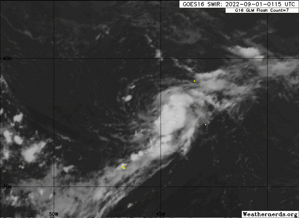
Satellite imagery indicates that the low pressure area over the North Atlantic west of the Azores has developed a well-defined circulation and convective banding in the eastern semicircle. Based on this structure, advisories are being initiated on Tropical Depression Five with an initial intensity of 30 kt.
Despite the high latitude, the cyclone is in an area of light steering currents on the southeast and south side of an anomalously strong mid-level anticyclone. This should result in a slow motion for the next three days or so, with the guidance showing an eastward drift followed by a westward drift. After three days, the anticyclone is forecast to move eastward and weaken as the mid-latitude westerlies start encroaching on the system. The large-scale models are not in good agreement with how this will steer the cyclone, with the GFS and Canadian showing a general motion toward the east while the UKMET and ECMWF forecast a more northward motion. The track forecast is close to all of the guidance for the first three days, and then calls for a northeastward motion between the HFIP Corrected Consensus and the other consensus models at days 4 and 5.
The sea surface temperatures in the area are warmer than normal - near 27C. This warm water, combined with a forecast environment of light- to moderate westerly shear for the next three days or so, should allow steady strengthening. The intensity forecast calls for the system to become a tropical storm later today, a hurricane in about two days, and reach a peak intensity of 80 kt in about 4 days. It should be noted that this forecast is close to the intensity consensus, and there are models forecasting more intensification. After four days, motion over cooler water and increasing shear should cause the cyclone to weaken.
Last edited by Jelmergraaff on Thu Sep 01, 2022 4:19 am, edited 2 times in total.
3 likes
20-year old meteorologist from The Netherlands. Interested in all fields of meteorology, including tropical systems like hurricanes.
-
MHC Tracking

- Tropical Storm
- Posts: 169
- Joined: Mon Mar 15, 2021 10:05 am
Re: ATL: FIVE - Tropical Depression
HAFS, HWRF, HMON, GFS, ICON all take this to cat 2+. Wonder if it'll be able to get to ~90-95 kt considering the very favorable upper-level conditions modeled + significantly above average SSTs.
0 likes

Re: ATL: FIVE - Tropical Depression
Why is this called TD5 instead of TD4? Is it because PTC-4 existed, or they’re planning to upgrade something in July or August in post-season?
0 likes
Irene '11 Sandy '12 Hermine '16 5/15/2018 Derecho Fay '20 Isaias '20 Elsa '21 Henri '21 Ida '21
I am only a meteorology enthusiast who knows a decent amount about tropical cyclones. Look to the professional mets, the NHC, or your local weather office for the best information.
I am only a meteorology enthusiast who knows a decent amount about tropical cyclones. Look to the professional mets, the NHC, or your local weather office for the best information.
-
MHC Tracking
- Tropical Storm
- Posts: 169
- Joined: Mon Mar 15, 2021 10:05 am
Re: ATL: FIVE - Tropical Depression
aspen wrote:Why is this called TD5 instead of TD4? Is it because PTC-4 existed, or they’re planning to upgrade something in July or August in post-season?
PTC was officially 04L, even though it never became a tropical cyclone.
0 likes
-
MHC Tracking
- Tropical Storm
- Posts: 169
- Joined: Mon Mar 15, 2021 10:05 am
Re: ATL: FIVE - Tropical Depression
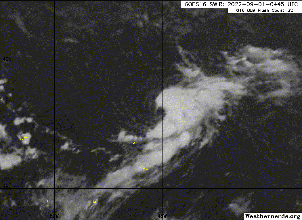
Looks like a TS now. Closed LL eyewall "cyan ring". Maybe some significant intensification coming in the near future?


3 likes
-
Category5Kaiju

- Category 5
- Posts: 3357
- Age: 22
- Joined: Thu Dec 24, 2020 12:45 pm
- Location: Seattle
Re: ATL: FIVE - Tropical Depression
MHC Tracking wrote:Looks like a TS now. Closed LL eyewall "cyan ring". Maybe some significant intensification coming in the near future?
https://cdn.discordapp.com/attachments/733552978572869632/1014852120597495808/image0.jpg
https://cdn.discordapp.com/attachments/733552978572869632/1014851674097074246/20220901.1027.gpm.37hbt.05L.INVEST.30kts.1013mb.38.1N.45.2W.055pc.jpg
I gotta say, it genuinely wouldn't surprise me to see this thing pull a Epsilon or Alex 2004, where it becomes a Cat 3 but at an unusually high latitude. I think that insane subtropical warmth could really help out here; in fact, I'd find it even more comical if this this meanders and adds a ton of ACE to what we have now lol
2 likes
Unless explicitly stated, all information covered in my posts is based on my opinions and observations. Please refer to a professional meteorologist or an accredited weather research agency otherwise, especially if serious decisions must be made in the event of a potentially life-threatening tropical storm or hurricane.

Re: ATL: FIVE - Tropical Depression
It's as if the Atlantic was intentionally holding off until after August 
This thing's rapidly organizing by the looks of it, even on satellite you can see the low level spin accelerating in almost real time
This thing's rapidly organizing by the looks of it, even on satellite you can see the low level spin accelerating in almost real time
0 likes
The above post is not official and should not be used as such. It is the opinion of the poster and may or may not be backed by sound meteorological data. It is not endorsed by any professional institution or storm2k.org. For official information, please refer to the NHC and NWS products.
-
cycloneye

- Admin

- Posts: 139080
- Age: 67
- Joined: Thu Oct 10, 2002 10:54 am
- Location: San Juan, Puerto Rico
Re: ATL: FIVE - Tropical Depression
AL, 05, 2022090112, , BEST, 0, 381N, 448W, 30, 1013, TD
0 likes
Visit the Caribbean-Central America Weather Thread where you can find at first post web cams,radars
and observations from Caribbean basin members Click Here
and observations from Caribbean basin members Click Here
Re: ATL: FIVE - Tropical Depression
cycloneye wrote:AL, 05, 2022090112, , BEST, 0, 381N, 448W, 30, 1013, TD
I sure hope they revise that. Sure these subtropics systems tend to form banding eyes pretty quickly and before they become hurricanes, but there’s no way a system with a fully formed eyewall is still a TD.
6 likes
Irene '11 Sandy '12 Hermine '16 5/15/2018 Derecho Fay '20 Isaias '20 Elsa '21 Henri '21 Ida '21
I am only a meteorology enthusiast who knows a decent amount about tropical cyclones. Look to the professional mets, the NHC, or your local weather office for the best information.
I am only a meteorology enthusiast who knows a decent amount about tropical cyclones. Look to the professional mets, the NHC, or your local weather office for the best information.
Re: ATL: INVEST 93L - Discussion
Category5Kaiju wrote:wxman57 wrote:wx98 wrote:Even if it doesn’t get named operationally today this could be a case where cyclogenesis gets backed up in post season. August may not quite make it after all.
This system will be around for a while. I'm becoming confident it will be the first hurricane of the season. Could reach Portugal or France at hurricane strength. Question is, will it still be tropical then?
I mean it is an interesting thought, but bona fide hurricanes threatening Europe are rare but not unheard of. Vince 2005 and Ophelia 2017 come to mind.
Vince made landfall near the Spain-Portugal border as a weakening depression and Ophelia was extra-tropical when it came ashore in Ireland (https://en.wikipedia.org/wiki/2017%E2%8 ... ne_Ophelia), so neither of those were bona fide European hurricanes. It is impossible for a true hurricane to hit Europe outside of the Azores because the sea temperatures and atmospheric winds are always extremely hostile. What we get are former hurricanes that have interacted with the polar jet stream and transitioned into extra-tropical storms.
2 likes

Re: ATL: INVEST 93L - Discussion
al78 wrote:Category5Kaiju wrote:wxman57 wrote:
This system will be around for a while. I'm becoming confident it will be the first hurricane of the season. Could reach Portugal or France at hurricane strength. Question is, will it still be tropical then?
I mean it is an interesting thought, but bona fide hurricanes threatening Europe are rare but not unheard of. Vince 2005 and Ophelia 2017 come to mind.
Vince made landfall near the Spain-Portugal border as a weakening depression and Ophelia was extra-tropical when it came ashore in Ireland (https://en.wikipedia.org/wiki/2017%E2%8 ... ne_Ophelia), so neither of those were bona fide European hurricanes. It is impossible for a true hurricane to hit Europe outside of the Azores because the sea temperatures and atmospheric winds are always extremely hostile. What we get are former hurricanes that have interacted with the polar jet stream and transitioned into extra-tropical storms.
Indeed, subtropical storm Alpha back in 2020 is as far as I know the only (sub)tropical storm to make landfall in Portugal since observations officially started. Note that London is roughly at the same latitude as Calgary, Canada. And even Madrid is 'only' at the latitude of NYC. All Europe can get are transitioning systems that are either extremely resiliant (= Alpha) or very strong and thus still quite damaging even in their weakend state (= Ophelia). I mean never say never (especially with rising sea temperatures due to global warming), but even then I think any tropical system threatening Europe will remain a rarity. Hopefully I won't have to adjust this statement in a week or so. If you really want some tropical action in Europe, I'd recommend to look to the Mediterranean Sea. Only 2 years ago cyclone Ianos reached cat 2 intensity (according to Wikipedia) before landfall in Greece. Bit off-topic, but there really should be an official agency in charge of naming and tracking those storms.
1 likes
-
tolakram
- Admin
- Posts: 19165
- Age: 60
- Joined: Sun Aug 27, 2006 8:23 pm
- Location: Florence, KY (name is Mark)
Re: ATL: FIVE - Tropical Depression
That's no TD, that's a TS rapidly strengthening in my opinion, might already be a hurricane.
4 likes
M a r k
- - - - -
Join us in chat: Storm2K Chatroom Invite. Android and IOS apps also available.
The posts in this forum are NOT official forecasts and should not be used as such. Posts are NOT endorsed by any professional institution or STORM2K.org. For official information and forecasts, please refer to NHC and NWS products.
Who is online
Users browsing this forum: No registered users and 68 guests