EPAC: KAY - Post-Tropical

Moderator: S2k Moderators

Message
Author
User avatar
cycloneye
Admin
Admin
Posts: 139027
Age: 67
Joined: Thu Oct 10, 2002 10:54 am
Location: San Juan, Puerto Rico

Re: EPAC: KAY - Hurricane

#101 Postby cycloneye » Mon Sep 05, 2022 7:57 pm

EP, 12, 2022090600, , BEST, 0, 159N, 1077W, 70, 980, HU


https://ftp.nhc.noaa.gov/atcf/btk/bep122022.dat
0 likes   
Visit the Caribbean-Central America Weather Thread where you can find at first post web cams,radars
and observations from Caribbean basin members Click Here

User avatar
ScottNAtlanta
Category 5
Category 5
Posts: 1998
Joined: Sat May 25, 2013 3:11 pm
Location: Atlanta, GA

Re: EPAC: KAY - Hurricane

#102 Postby ScottNAtlanta » Mon Sep 05, 2022 8:29 pm

The looks to be shrinking quite a bit from earlier. Has 2 hot towers starting to circle the center
0 likes   
The posts in this forum are NOT official forecast and should not be used as such. They are just the opinion of the poster and may or may not be backed by sound meteorological data. They are NOT endorsed by any professional institution or storm2k.org. For official information, please refer to the NHC and NWS products.

Sciencerocks
Category 5
Category 5
Posts: 7282
Age: 38
Joined: Thu Jul 06, 2017 1:51 am

Re: EPAC: KAY - Hurricane

#103 Postby Sciencerocks » Mon Sep 05, 2022 9:28 pm

Image
0 likes   

User avatar
cycloneye
Admin
Admin
Posts: 139027
Age: 67
Joined: Thu Oct 10, 2002 10:54 am
Location: San Juan, Puerto Rico

Re: EPAC: KAY - Hurricane

#104 Postby cycloneye » Mon Sep 05, 2022 9:55 pm

Hurricane Kay Discussion Number 7
NWS National Hurricane Center Miami FL EP122022
900 PM MDT Mon Sep 05 2022

Kay was upgraded to a hurricane earlier today based on valuable data
that was received from the Air Force Hurricane Hunters just before
the previous advisory issuance. The aircraft reported dropsonde data
that supported a minimum pressure around 980 mb, along with
flight-level winds of 85 kt at 850 mb and SFMR winds up to 71 kt in
the eastern portion of the cyclone. There were some earlier hints of
a ragged eye trying to emerge in visible imagery, but the center is
still obscured by a small central dense overcast. The inner core
structure of the cyclone does not appear to have improved much based
on a couple of recent passive microwave overpasses, as some dry air
has wrapped into the western and southern portions of the
circulation. Based on the earlier aircraft data, the intensity of
Kay is held at 70 kt for this advisory.

The hurricane is moving west-northwestward at 285/9 kt. The track
guidance for Kay over the next few days remains in good agreement.
Kay is expected to turn northwestward on Tuesday and then
north-northwestward by early Wednesday while moving toward or to the
west of the Baja California peninsula. While the core of the storm
is still forecast to remain offshore, the large wind field could
bring tropical-storm-force winds to the southern portion of Baja
California by early Wednesday. The hurricane is forecast to make its
closest approach to the west-central portion of Baja California late
Thursday into Friday. The official NHC forecast lies very close to
the HFIP corrected consensus approach (HCCA) and has been nudged
slightly to the right of the previous one. It is noted that the GFS
and ECMWF still lie on the eastern edge of the guidance envelope.

Kay has significantly strengthened today despite some moderate
northeasterly deep-layer shear diagnosed by the SHIPS guidance over
the system. This shear is forecast to diminish in a day or so, while
Kay remains over very warm SSTs and in a moist and unstable
environment. Thus, more strengthening is anticipated and Kay could
approach major hurricane strength in 36-48 h. The official NHC
forecast is very similar to the previous one and lies slightly above
the IVCN aid and closer to HCCA. By early Thursday, drier air and
cooler SSTs at higher latitudes will cause Kay to begin weakening.
The cyclone is forecast to lose its organized convection and become
a post-tropical low by day 5.

The government of Mexico has extended the Tropical Storm Watch
northward from Puerto San Andresito to Punta Abreojos. Additional
tropical storm or hurricane watches or warnings could be necessary
for portions of Baja California later tonight or on Tuesday.

KEY MESSAGES:

1. Gusts to tropical-storm-force and rough surf along the coast of
southwestern Mexico are expected through Tuesday. In addition,
heavy rainfall from Kay could lead to flash flooding, including
landslides, across portions of the Mexican Riviera and western
Mexico through Wednesday night.

2. Tropical storm conditions are possible across the southern Baja
California peninsula by early Wednesday, where a Tropical Storm
Watch has been issued.

3. While the details of the long-range track and intensity forecasts
remain uncertain, there is increasing risk of significant wind,
surf, and rainfall impacts across the central portion of the Baja
California peninsula later this week. A tropical storm or hurricane
watch could be issued for that region by Tuesday.


FORECAST POSITIONS AND MAX WINDS

INIT 06/0300Z 16.0N 108.1W 70 KT 80 MPH
12H 06/1200Z 17.1N 109.6W 80 KT 90 MPH
24H 07/0000Z 18.3N 111.2W 90 KT 105 MPH
36H 07/1200Z 19.9N 112.5W 95 KT 110 MPH
48H 08/0000Z 21.7N 113.4W 95 KT 110 MPH
60H 08/1200Z 23.7N 114.1W 85 KT 100 MPH
72H 09/0000Z 25.6N 115.0W 75 KT 85 MPH
96H 10/0000Z 28.5N 116.8W 50 KT 60 MPH
120H 11/0000Z 30.0N 120.0W 35 KT 40 MPH...POST-TROPICAL

$$
Forecaster Reinhart
0 likes   
Visit the Caribbean-Central America Weather Thread where you can find at first post web cams,radars
and observations from Caribbean basin members Click Here

zeehag
Tropical Storm
Tropical Storm
Posts: 172
Age: 75
Joined: Sun Jul 17, 2011 9:49 pm
Location: mazatlan,sinaloa, mexico, fixing patricia's mess.
Contact:

Re: EPAC: KAY - Hurricane

#105 Postby zeehag » Mon Sep 05, 2022 11:04 pm

kay is a wet one.. very very wet one. it is pouring hard in mazatlan. baja going to drown if not washed away. i hope everyone prepped well.
0 likes   
life is an adventure meant to be LIVED!!!

http://www.sksolitarybird.org

User avatar
cycloneye
Admin
Admin
Posts: 139027
Age: 67
Joined: Thu Oct 10, 2002 10:54 am
Location: San Juan, Puerto Rico

Re: EPAC: KAY - Hurricane

#106 Postby cycloneye » Tue Sep 06, 2022 4:13 am

Hurricane Kay Discussion Number 8
NWS National Hurricane Center Miami FL EP122022
300 AM MDT Tue Sep 06 2022

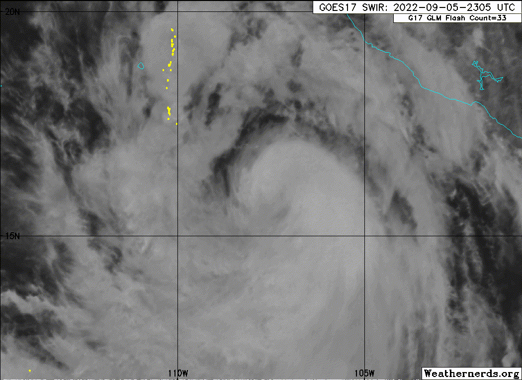
The satellite presentation of Kay has improved within the past
couple of hours. A curved band with cloud top temperatures below
-85C has wrapped around the center and has formed a ragged
banding-type eye in infrared imagery. The latest subjective and
objective Dvorak satellite estimates are all around 65 kt, but with
the earlier reconnaissance data supporting a higher intensity and
the recent improvement in structure, the initial intensity has been
raised to 75 kt. Another Air Force Reserve reconnaissance aircraft
is scheduled to investigate Kay this afternoon.

The much-anticipated northwestward turn appears to have occurred,
and the initial motion estimate is now 310/11 kt. Kay is forecast
to move on a northwestward heading during the next 24 to 36 hours
around a mid-level ridge centered over Mexico. After that time,
the hurricane is forecast to turn north-northwestward, bringing the
core near the west-central coast of the Baja peninsula in 60-72
hours. Some of the dynamical track models including the HWRF,
GFS and GFS ensemble mean, have made a noticeable eastward shift
over the past few cycles, while the ECMWF has changed little. The
updated NHC track forecast has been adjusted slightly east of the
previous advisory out of respect for the aforementioned models, but
it is not quite as far east as the latest GFS, GFS ensemble mean or
HFIP corrected consensus. The forecast is a blend of the ECMWF and
GFS and is just east of the simple consensus aids.

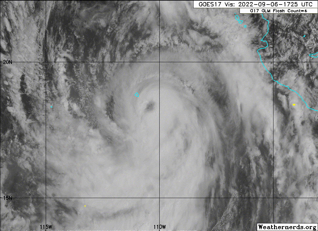
Kay's outflow remains somewhat constricted over the northeastern
quadrant due to moderate northeasterly shear. However, the shear
is forecast to relax over the next 24 to 36 hours, and given the
recent improvement in organization, additional strengthening is
expected during that time. The NHC forecast has been raised from
the previous advisory and is near the upper-end of the guidance in
best agreement with the SHIPS model. After 36 hours, Kay will be
moving over decreasing sea surface temperatures and weakening
should begin. Although Kay is likely to weaken before it makes
its closest approach to the west-central coast of the Baja
peninsula, it is forecast to remain a large and strong hurricane at
that time. In addition, winds and rainfall impacts will extend far
form the center so users should not focus on the exact forecast
track.

The government of Mexico has issued a Tropical Storm Warning for
the southern portions of the Baja California peninsula. Additional
tropical storm or hurricane watches or warnings could be necessary
for portions of Baja California later today.

KEY MESSAGES:

1. Heavy rainfall from Kay could lead to flash flooding, including
landslides, across portions of western Mexico, including the Baja
California peninsula, through Thursday night.

2. Tropical storm conditions are expected over portions of the
southern Baja California peninsula beginning Wednesday morning,
where a Tropical Storm Warning is now in effect.

3. While the details of the long-range track and intensity forecasts
remain uncertain, there is increasing risk of significant wind,
surf, and rainfall impacts across the central portion of the Baja
California peninsula later this week. A tropical storm or hurricane
watch could be issued for that region later today.


FORECAST POSITIONS AND MAX WINDS

INIT 06/0900Z 17.0N 108.9W 75 KT 85 MPH
12H 06/1800Z 18.0N 110.4W 85 KT 100 MPH
24H 07/0600Z 19.4N 111.9W 95 KT 110 MPH
36H 07/1800Z 21.1N 113.0W 100 KT 115 MPH
48H 08/0600Z 23.1N 113.7W 95 KT 110 MPH
60H 08/1800Z 25.1N 114.5W 80 KT 90 MPH
72H 09/0600Z 26.8N 115.3W 65 KT 75 MPH
96H 10/0600Z 29.6N 117.6W 45 KT 50 MPH
120H 11/0600Z 30.3N 120.3W 30 KT 35 MPH...POST-TROP/REMNT LOW

$$
Forecaster Brown
0 likes   
Visit the Caribbean-Central America Weather Thread where you can find at first post web cams,radars
and observations from Caribbean basin members Click Here

User avatar
cycloneye
Admin
Admin
Posts: 139027
Age: 67
Joined: Thu Oct 10, 2002 10:54 am
Location: San Juan, Puerto Rico

Re: EPAC: KAY - Hurricane

#107 Postby cycloneye » Tue Sep 06, 2022 8:26 am

EP, 12, 2022090612, , BEST, 0, 176N, 1096W, 75, 977, HU


https://ftp.nhc.noaa.gov/atcf/btk/bep122022.dat
0 likes   
Visit the Caribbean-Central America Weather Thread where you can find at first post web cams,radars
and observations from Caribbean basin members Click Here

User avatar
cycloneye
Admin
Admin
Posts: 139027
Age: 67
Joined: Thu Oct 10, 2002 10:54 am
Location: San Juan, Puerto Rico

Re: EPAC: KAY - Hurricane

#108 Postby cycloneye » Tue Sep 06, 2022 8:30 am

Image
0 likes   
Visit the Caribbean-Central America Weather Thread where you can find at first post web cams,radars
and observations from Caribbean basin members Click Here

User avatar
cycloneye
Admin
Admin
Posts: 139027
Age: 67
Joined: Thu Oct 10, 2002 10:54 am
Location: San Juan, Puerto Rico

Re: EPAC: KAY - Hurricane

#109 Postby cycloneye » Tue Sep 06, 2022 9:48 am

Hurricane Kay Discussion Number 9
NWS National Hurricane Center Miami FL EP122022
900 AM MDT Tue Sep 06 2022

Satellite data indicate that Kay has been relatively steady in
strength during the past several hours. A ragged eye feature has
occasionally been apparent, and microwave data show that the eyewall
and rainbands are most organized on the south side. The latest
satellite intensity estimates range from 65 to 77 kt, and based on
that data, the initial intensity is held at 75 kt. An Air Force
Hurricane Hunter aircraft is scheduled to investigate Kay later
today. It should be noted that Kay is a fairly large hurricane with
its tropical-storm-force winds estimated to extend outward up to 175
miles from the center. Kay is also producing a large area of high
seas, with swells currently affecting portions of southwestern
Mexico and the southern Baja California peninsula.

Kay is moving northwestward at 13 kt and it appears to be moving
along the previous forecast track. The track models have barely
changed this cycle and continue to show a northwest to
north-northwest motion continuing for the next few days as the
hurricane moves in the flow on the western periphery of a ridge over
Mexico. This should take the core of Kay very near the west-central
Baja California peninsula on Thursday and Friday. After that time,
a turn to the left is predicted as the system is steered by a low-
to mid-level ridge over the western United States. The NHC track
forecast is basically the same as the previous one and lies closest
to the HCCA consensus model.

The hurricane is still feeling some effects from moderate northerly
vertical wind shear, but the models suggest that the shear should
decrease during the next day or so. The anticipated more conducive
upper-level wind pattern combined with warm SSTs and a moist
environment should allow Kay to strengthen during the next 36 hours,
and it could become a major hurricane during that time. Thereafter,
sharply cooler SSTs and drier air should end the opportunity for
strengthening and induce steady weakening. Kay is expected to
become a post-tropical cyclone in 4 to 5 days when it is forecast
to be over quite cool SSTs of 21-22 C. The NHC intensity forecast
lies near the high end of the guidance, especially during the first
48 hours.

Although Kay is likely to weaken before it makes its closest
approach to the west-central coast of the Baja peninsula, it is
forecast to remain a large and strong hurricane at that time. In
addition, winds, surf, and rainfall impacts will extend far from the
center so users should not focus on the exact forecast track.


KEY MESSAGES:

1. Heavy rainfall from Kay could lead to flash flooding, including
landslides, across portions of western Mexico, including the Baja
California peninsula, through Thursday night.

2. Tropical storm conditions are expected over portions of the
southern Baja California peninsula beginning Wednesday morning,
where a Tropical Storm Warning is now in effect.

3. While the details of the long-range track and intensity forecasts
remain uncertain, there is increasing risk of significant wind,
surf, and rainfall impacts across the central portion of the Baja
California peninsula later this week. A tropical storm or hurricane
watch could be issued for that region later today.


FORECAST POSITIONS AND MAX WINDS

INIT 06/1500Z 18.0N 110.0W 75 KT 85 MPH
12H 07/0000Z 19.1N 111.4W 85 KT 100 MPH
24H 07/1200Z 20.7N 112.6W 95 KT 110 MPH
36H 08/0000Z 22.5N 113.5W 100 KT 115 MPH
48H 08/1200Z 24.6N 114.3W 90 KT 105 MPH
60H 09/0000Z 26.4N 115.2W 75 KT 85 MPH
72H 09/1200Z 28.0N 116.0W 60 KT 70 MPH
96H 10/1200Z 30.2N 118.6W 45 KT 50 MPH
120H 11/1200Z 30.5N 120.9W 30 KT 35 MPH...POST-TROP/REMNT LOW

$$
Forecaster Cangialosi
0 likes   
Visit the Caribbean-Central America Weather Thread where you can find at first post web cams,radars
and observations from Caribbean basin members Click Here

Sciencerocks
Category 5
Category 5
Posts: 7282
Age: 38
Joined: Thu Jul 06, 2017 1:51 am

Re: EPAC: KAY - Hurricane

#110 Postby Sciencerocks » Tue Sep 06, 2022 10:46 am

Image
0 likes   

User avatar
Iceresistance
Category 5
Category 5
Posts: 8910
Age: 20
Joined: Sat Oct 10, 2020 9:45 am
Location: Tecumseh, OK/Norman, OK

Re: EPAC: KAY - Hurricane

#111 Postby Iceresistance » Tue Sep 06, 2022 10:56 am

AF307 is on the way to Kay, but it appears that there is no public data since 10 AM CDT.
0 likes   
Bill 2015 & Beta 2020

Winter 2020-2021 :cold:

All observations are in Tecumseh, OK unless otherwise noted.

Winter posts are focused mainly for Oklahoma & Texas.

Take any of my forecasts with a grain of salt, refer to the NWS, SPC, and NHC for official information

Never say Never with weather! Because ANYTHING is possible!

User avatar
Yellow Evan
Professional-Met
Professional-Met
Posts: 15951
Age: 25
Joined: Fri Jul 15, 2011 12:48 pm
Location: Henderson, Nevada/Honolulu, HI
Contact:

Re: EPAC: KAY - Hurricane

#112 Postby Yellow Evan » Tue Sep 06, 2022 2:03 pm

At least for now Kay has a clear eye but it’s still vulnerable to dry air intrusions. Kay has about ~30 hours left so some time for proper strengthening still.
0 likes   

zzh
Category 1
Category 1
Posts: 375
Joined: Fri Aug 27, 2021 2:18 pm

Re: EPAC: KAY - Hurricane

#113 Postby zzh » Tue Sep 06, 2022 2:21 pm

Recon shows it barely a hurricane. NHC should downgrade it to 65kt
0 likes   

User avatar
ElectricStorm
Category 5
Category 5
Posts: 4523
Age: 23
Joined: Tue Aug 13, 2019 11:23 pm
Location: Skiatook, OK / Norman, OK

Re: EPAC: KAY - Hurricane

#114 Postby ElectricStorm » Tue Sep 06, 2022 2:22 pm

12E KAY 220906 1800 18.4N 110.7W EPAC 80 975
0 likes   
I am in no way a professional. Take what I say with a grain of salt as I could be totally wrong. Please refer to the NHC, NWS, or SPC for official information.

Boomer Sooner!

User avatar
aspen
Category 5
Category 5
Posts: 8056
Joined: Sat Oct 12, 2019 7:10 pm
Location: Connecticut, USA

Re: EPAC: KAY - Hurricane

#115 Postby aspen » Tue Sep 06, 2022 2:23 pm

zzh wrote:Recon shows it barely a hurricane. NHC should downgrade it to 65kt

70kt seems to be a good estimate, and Kay is a much better looking storm than (possibly) Hurricane Earl. Let’s see what the other quadrants yield.
0 likes   
Irene '11 Sandy '12 Hermine '16 5/15/2018 Derecho Fay '20 Isaias '20 Elsa '21 Henri '21 Ida '21

I am only a meteorology enthusiast who knows a decent amount about tropical cyclones. Look to the professional mets, the NHC, or your local weather office for the best information.

zzh
Category 1
Category 1
Posts: 375
Joined: Fri Aug 27, 2021 2:18 pm

Re: EPAC: KAY - Hurricane

#116 Postby zzh » Tue Sep 06, 2022 2:29 pm

aspen wrote:
zzh wrote:Recon shows it barely a hurricane. NHC should downgrade it to 65kt

70kt seems to be a good estimate, and Kay is a much better looking storm than (possibly) Hurricane Earl. Let’s see what the other quadrants yield.

Recon supports 65 at most.
East eyewall is the so called dangerous semicircle (in this case) where max wind typically occurs. Other quadrants should have lower winds.
0 likes   

User avatar
Iceresistance
Category 5
Category 5
Posts: 8910
Age: 20
Joined: Sat Oct 10, 2020 9:45 am
Location: Tecumseh, OK/Norman, OK

Re: EPAC: KAY - Hurricane

#117 Postby Iceresistance » Tue Sep 06, 2022 3:23 pm

Eye about to pass over Socorro Island (or one of them)
0 likes   
Bill 2015 & Beta 2020

Winter 2020-2021 :cold:

All observations are in Tecumseh, OK unless otherwise noted.

Winter posts are focused mainly for Oklahoma & Texas.

Take any of my forecasts with a grain of salt, refer to the NWS, SPC, and NHC for official information

Never say Never with weather! Because ANYTHING is possible!

User avatar
cycloneye
Admin
Admin
Posts: 139027
Age: 67
Joined: Thu Oct 10, 2002 10:54 am
Location: San Juan, Puerto Rico

Re: EPAC: KAY - Hurricane

#118 Postby cycloneye » Tue Sep 06, 2022 4:02 pm

BULLETIN
Hurricane Kay Advisory Number 10
NWS National Hurricane Center Miami FL EP122022
300 PM MDT Tue Sep 06 2022

...HURRICANE WATCH AND NEW TROPICAL STORM WARNINGS ISSUED FOR
PORTIONS OF THE BAJA CALIFORNIA PENINSULA...


SUMMARY OF 300 PM MDT...2100 UTC...INFORMATION
----------------------------------------------
LOCATION...18.8N 111.0W
ABOUT 290 MI...470 KM SSW OF THE SOUTHERN TIP OF BAJA CALIFORNIA
MAXIMUM SUSTAINED WINDS...85 MPH...140 KM/H
PRESENT MOVEMENT...NW OR 310 DEGREES AT 15 MPH...24 KM/H
MINIMUM CENTRAL PRESSURE...978 MB...28.88 INCHES


WATCHES AND WARNINGS
--------------------
CHANGES WITH THIS ADVISORY:

The government of Mexico has issued a Hurricane Watch for the west
coast of the Baja California peninsula from Puerto Cortes to Punta
Eugenia.

A Tropical Storm Warning has been extended northward to
Punta Abreojos on the west coast and to Santa Rosalia on the east
coast.

A Tropical Storm Watch has been issued from Punta Eugenia to
San Jose De Las Palomas on the west coast and from Santa Rosalia to
Bahia De Los Angeles on the east coast.

SUMMARY OF WATCHES AND WARNINGS IN EFFECT:

A Hurricane Watch is in effect for...
* Puerto Cortes to Punta Eugenia

A Tropical Storm Warning is in effect for...
* Punta Abreojos southward to Cabo San Lucas
* Cabo San Lucas northward to Santa Rosalia

A Tropical Storm Watch is in effect for...
* North of Santa Rosalia to Bahia De Los Angeles
* North of Punta Eugenia to San Jose De Las Palomas


Hurricane Kay Discussion Number 10
NWS National Hurricane Center Miami FL EP122022
300 PM MDT Tue Sep 06 2022

Kay continues to be relatively steady in strength. The Air
Force Hurricane Hunters so far have found peak flight-level winds
of 75 kt, and the initial intensity is held at 75 kt pending
the completion of the reconnaissance mission. The minimum pressure
is estimated to be 978 mb based on the aircraft data. The center
of Kay is currently over Socorro Island, and the island is about to
experience strong winds on the system's east side. The aircraft
data and a recent ASCAT-B pass indicate that Kay is a large
hurricane, with its tropical-storm- force winds extending outward
about 200 miles from the center. Kay is also producing a large area
of high seas, with swells currently affecting portions of
southwestern Mexico and the southern Baja California peninsula.

Kay is moving northwestward and it continues moving along the
previous forecast track. A northwest to north-northwest
motion is expected during the next few days, which will likely
bring the core of Kay very near the west-central Baja California
coast on Thursday and Friday. After that time, a turn to the left
is predicted when the system is steered by a low- to mid-level
ridge over the western United States. The GFS has shifted a bit to
the right this cycle, but the other models have generally held
steady. Little change was made to the previous NHC track forecast
and this one lies near the middle of the guidance envelope.

The hurricane is still feeling some effects from moderate northerly
vertical wind shear, but the models suggest that the shear should
decrease during the next day or so. The anticipated more conducive
upper-level wind pattern combined with warm SSTs and a moist
environment should allow Kay to strengthen during the next 24-36
hours, and it could become a major hurricane during that time.
Thereafter, sharply cooler SSTs and drier air should end the
opportunity for strengthening and induce steady weakening. Kay is
expected to become a post-tropical cyclone in 4 to 5 days when it
is forecast to be over quite cool SSTs of 21-22 C. The NHC
intensity forecast is near or a little above the high end of the
guidance, especially during the first 36-48 hours.

Although Kay is likely to weaken before it makes its closest
approach to the west-central coast of the Baja peninsula, it is
forecast to remain a large and dangerous hurricane through that
time. In addition, high wind, surf, and rainfall impacts will
extend far from the center so users should not focus on the exact
forecast track.

KEY MESSAGES:

1. Heavy rainfall from Kay could lead to flash flooding, including
landslides, across portions of the Baja California peninsula
through Friday.

2. Tropical storm conditions are expected over portions of the
Baja California peninsula beginning Wednesday morning, where a
Tropical Storm Warning is in effect.

3. Hurricane conditions are possible along portions of the
west-central Baja California coast on Thursday, where a hurricane
watch has been issued. Additional tropical storm watches and
warnings for the northern Baja California peninsula could be
required tonight and Wednesday.


FORECAST POSITIONS AND MAX WINDS

INIT 06/2100Z 18.8N 111.0W 75 KT 85 MPH
12H 07/0600Z 19.8N 112.1W 85 KT 100 MPH
24H 07/1800Z 21.6N 113.2W 95 KT 110 MPH
36H 08/0600Z 23.6N 113.9W 95 KT 110 MPH
48H 08/1800Z 25.9N 114.7W 85 KT 100 MPH
60H 09/0600Z 27.8N 115.6W 70 KT 80 MPH
72H 09/1800Z 29.3N 117.0W 60 KT 70 MPH
96H 10/1800Z 30.7N 119.8W 40 KT 45 MPH
120H 11/1800Z 30.5N 121.8W 30 KT 35 MPH...POST-TROP/REMNT LOW

$$
Forecaster Cangialosi
0 likes   
Visit the Caribbean-Central America Weather Thread where you can find at first post web cams,radars
and observations from Caribbean basin members Click Here

Sciencerocks
Category 5
Category 5
Posts: 7282
Age: 38
Joined: Thu Jul 06, 2017 1:51 am

Re: EPAC: KAY - Hurricane

#119 Postby Sciencerocks » Tue Sep 06, 2022 4:15 pm

Image
0 likes   

User avatar
Yellow Evan
Professional-Met
Professional-Met
Posts: 15951
Age: 25
Joined: Fri Jul 15, 2011 12:48 pm
Location: Henderson, Nevada/Honolulu, HI
Contact:

Re: EPAC: KAY - Hurricane

#120 Postby Yellow Evan » Tue Sep 06, 2022 5:14 pm

zzh wrote:
aspen wrote:
zzh wrote:Recon shows it barely a hurricane. NHC should downgrade it to 65kt

70kt seems to be a good estimate, and Kay is a much better looking storm than (possibly) Hurricane Earl. Let’s see what the other quadrants yield.

Recon supports 65 at most.
East eyewall is the so called dangerous semicircle (in this case) where max wind typically occurs. Other quadrants should have lower winds.


With such large RMW, undersampling becomes an issue especially SFMR as that does not take it into account.
0 likes   


Return to “2022”

Who is online

Users browsing this forum: No registered users and 42 guests