EPAC: KAY - Post-Tropical

Moderator: S2k Moderators

Message
Author
ChrisH-UK
Category 1
Category 1
Posts: 421
Joined: Sat May 29, 2021 8:22 am

Re: EPAC: KAY - Hurricane

#141 Postby ChrisH-UK » Wed Sep 07, 2022 10:19 am

With the path that Kaye is taking there's going to be a bit of surge to contend with along the west coast they should get a surge between 4-6 feet, the Gulf of California could see over 10 feet of surge been pushed up the gulf by Kaye

Source NOAA Coastal Emergency Risk Assessment - https://cera.coastalrisk.live/s/e95e

Image
3 likes   

ChrisH-UK
Category 1
Category 1
Posts: 421
Joined: Sat May 29, 2021 8:22 am

Re: EPAC: KAY - Hurricane

#142 Postby ChrisH-UK » Wed Sep 07, 2022 11:06 am

Here is the latest radar of Kaye from Los Cabos showing good structure.

Source = https://smn.conagua.gob.mx/es/observand ... or-radares

0 likes   

User avatar
Yellow Evan
Professional-Met
Professional-Met
Posts: 15951
Age: 25
Joined: Fri Jul 15, 2011 12:48 pm
Location: Henderson, Nevada/Honolulu, HI
Contact:

Re: EPAC: KAY - Hurricane

#143 Postby Yellow Evan » Wed Sep 07, 2022 11:09 am

0 likes   

Sciencerocks
Category 5
Category 5
Posts: 7282
Age: 38
Joined: Thu Jul 06, 2017 1:51 am

Re: EPAC: KAY - Hurricane

#144 Postby Sciencerocks » Wed Sep 07, 2022 11:30 am

Image
0 likes   

User avatar
Yellow Evan
Professional-Met
Professional-Met
Posts: 15951
Age: 25
Joined: Fri Jul 15, 2011 12:48 pm
Location: Henderson, Nevada/Honolulu, HI
Contact:

Re: EPAC: KAY - Hurricane

#145 Postby Yellow Evan » Wed Sep 07, 2022 11:50 am

Image

Image

Image
1 likes   

User avatar
galaxy401
Category 5
Category 5
Posts: 2298
Age: 28
Joined: Sat Aug 25, 2012 9:04 pm
Location: Casa Grande, Arizona

Re: EPAC: KAY - Hurricane

#146 Postby galaxy401 » Wed Sep 07, 2022 12:49 pm

Despite recon finding the pressure around where the NHC advisory has it, they barely found any hurricane winds in that first pass.
0 likes   
Got my eyes on moving right into Hurricane Alley: Florida.

User avatar
Kingarabian
S2K Supporter
S2K Supporter
Posts: 15432
Joined: Sat Aug 08, 2009 3:06 am
Location: Honolulu, Hawaii

Re: EPAC: KAY - Hurricane

#147 Postby Kingarabian » Wed Sep 07, 2022 1:23 pm

Not surprised guessing how dry the core is and nonchalant the eyewall is. Dvorak over estimates in this area. That being said the wind and rain threat remains.
1 likes   
RIP Kobe Bryant

User avatar
ElectricStorm
Category 5
Category 5
Posts: 4523
Age: 23
Joined: Tue Aug 13, 2019 11:23 pm
Location: Skiatook, OK / Norman, OK

Re: EPAC: KAY - Hurricane

#148 Postby ElectricStorm » Wed Sep 07, 2022 2:05 pm

Eye drop supports 971mb. Recon probably supports around 70kts at most. Based on recon, it's probably weaker than Earl
0 likes   
I am in no way a professional. Take what I say with a grain of salt as I could be totally wrong. Please refer to the NHC, NWS, or SPC for official information.

Boomer Sooner!

CrazyC83
Professional-Met
Professional-Met
Posts: 33393
Joined: Tue Mar 07, 2006 11:57 pm
Location: Deep South, for the first time!

Re: EPAC: KAY - Hurricane

#149 Postby CrazyC83 » Wed Sep 07, 2022 3:52 pm

Advisory is a "generous" 85 kt. I'd have lowered it down to 70 kt, and it likely peaked no higher than 75-80 kt.

One issue is that the storm is so large that the P-W relationships are off.
0 likes   

User avatar
cycloneye
Admin
Admin
Posts: 139019
Age: 67
Joined: Thu Oct 10, 2002 10:54 am
Location: San Juan, Puerto Rico

Re: EPAC: KAY - Hurricane

#150 Postby cycloneye » Wed Sep 07, 2022 3:56 pm

Hurricane Kay Discussion Number 14
NWS National Hurricane Center Miami FL EP122022
300 PM MDT Wed Sep 07 2022

After getting better organized this morning, the window for Kay to
intensify may be closing as the center has reached an area where
the sea surface temperatures have decreased to 26C. Data from an
Air Force Reserve Hurricane Hunter aircraft showed that the central
pressure was near 971 mb, but that the maximum 700-mb flight level
winds were only 82 kt, with lower surface winds estimates from the
SFMR. The aircraft also reported a decay of the eyewall structure
during the mission, which is matched by a decay in the eye and
eyewall structure seen in satellite imagery. The initial intensity
is reduced to 85 kt, and this could be a bit generous.

The forecast track takes the center over progressively cooler water
during the next several days, and continued steady weakening is
expected. However, the weakening may be slower than normal since
part of the large circulation will be over the warm Gulf of
California. Kay is still forecast to be a hurricane when it passes
near or over the western portion of the Baja California Peninsula in
24-36 h. After that, the cyclone should weaken below hurricane
strength by 48 h and below tropical storm strength after 72 h. The
new intensity forecast shows lower intensities than the previous
forecast and lies close to the intensity consensus models.

The initial motion is north-northwestward or 340/11 kt. A
mid-level ridge to the north and northeast of the hurricane should
continue to steer Kay generally north-northwestward for the next 48
h or so, taking the core of Kay very near or over the west-central
Baja California peninsula on Thursday and Friday. After that, the
weakening and increasingly shallow Kay is forecast to turn more
westward, and eventually southward, away from land as it becomes
steered by the flow on the south and east side of a low-level ridge
over the northeastern Pacific. There has been little change in the
track guidance since the previous advisory, and the new official
forecast track has only minor adjustments from the previous
forecast.

Kay is a very large tropical cyclone. It is producing an extensive
area of high seas, with swells affecting portions of southwestern
Mexico and the southern Baja California peninsula. Although Kay is
likely to weaken before it makes landfall or moves very close to the
west-central coast of the Baja peninsula, it is forecast to remain a
large and dangerous hurricane through that time. In addition, high
wind, surf, and rainfall impacts will extend far from the center so
users should not focus on the exact forecast track.

KEY MESSAGES:

1. As the center of Kay passes just offshore, heavy rainfall could
lead to flash flooding, including landslides, across the Baja
California peninsula and portions of mainland northwestern Mexico
through Saturday morning. Flash, urban, and small stream flooding
is possible across Southern California, especially in and near the
peninsular ranges, and Southwest Arizona, Friday night into
Saturday.

2. Hurricane conditions are expected along portions of the
west-central Baja California coast on Thursday and Thursday night,
and a hurricane warning is in effect for that area.

3. Tropical storm conditions are beginning over portions of the
Baja California peninsula, and these conditions are expected
to spread northward during the next day or so, where a
Tropical Storm Warning is in effect.


FORECAST POSITIONS AND MAX WINDS

INIT 07/2100Z 22.0N 113.0W 85 KT 100 MPH
12H 08/0600Z 23.8N 113.5W 80 KT 90 MPH
24H 08/1800Z 26.1N 114.5W 75 KT 85 MPH
36H 09/0600Z 28.2N 115.5W 65 KT 75 MPH
48H 09/1800Z 29.8N 116.8W 55 KT 65 MPH
60H 10/0600Z 30.8N 118.3W 45 KT 50 MPH
72H 10/1800Z 31.2N 119.6W 35 KT 40 MPH
96H 11/1800Z 31.0N 121.5W 25 KT 30 MPH...POST-TROP/REMNT LOW
120H 12/1800Z 29.0N 121.5W 20 KT 25 MPH...POST-TROP/REMNT LOW

$$
Forecaster Beven
0 likes   
Visit the Caribbean-Central America Weather Thread where you can find at first post web cams,radars
and observations from Caribbean basin members Click Here

Sciencerocks
Category 5
Category 5
Posts: 7282
Age: 38
Joined: Thu Jul 06, 2017 1:51 am

Re: EPAC: KAY - Hurricane

#151 Postby Sciencerocks » Wed Sep 07, 2022 7:22 pm

Image
0 likes   

User avatar
cycloneye
Admin
Admin
Posts: 139019
Age: 67
Joined: Thu Oct 10, 2002 10:54 am
Location: San Juan, Puerto Rico

Re: EPAC: KAY - Hurricane

#152 Postby cycloneye » Wed Sep 07, 2022 7:30 pm

EP, 12, 2022090800, , BEST, 0, 226N, 1129W, 80, 975, HU


https://ftp.nhc.noaa.gov/atcf/btk/bep122022.dat
0 likes   
Visit the Caribbean-Central America Weather Thread where you can find at first post web cams,radars
and observations from Caribbean basin members Click Here

Sciencerocks
Category 5
Category 5
Posts: 7282
Age: 38
Joined: Thu Jul 06, 2017 1:51 am

Re: EPAC: KAY - Hurricane

#153 Postby Sciencerocks » Wed Sep 07, 2022 9:14 pm

Image
0 likes   

User avatar
drezee
S2K Supporter
S2K Supporter
Posts: 3642
Joined: Mon Jun 09, 2003 12:49 pm
Location: FL

Re: EPAC: KAY - Hurricane

#154 Postby drezee » Wed Sep 07, 2022 9:38 pm

0 likes   

User avatar
cycloneye
Admin
Admin
Posts: 139019
Age: 67
Joined: Thu Oct 10, 2002 10:54 am
Location: San Juan, Puerto Rico

Re: EPAC: KAY - Hurricane

#155 Postby cycloneye » Wed Sep 07, 2022 9:58 pm

Hurricane Kay Discussion Number 15
NWS National Hurricane Center Miami FL EP122022
900 PM MDT Wed Sep 07 2022

Kay is still exhibiting a ragged-looking eye on enhanced infrared
imagery, but the surrounding cloud tops have been warming
significantly. The overall cloud pattern is becoming less
organized with some elongation from south to north. Upper-level
outflow is restricted over the western portion of the circulation.
Dvorak T-numbers are decreasing and the current intensity estimate
is lowered to 80 kt for this advisory, which is a compromise between
subjective Dvorak T and CI numbers. The earlier Hurricane Hunter
mission suggested that the satellite-estimated intensities were
probably a little on the high side.

Although the vertical wind shear is not forecast to increase much
during the next couple of days, SSTs beneath Kay will be steadily
cooling along with a gradual drying of the mid-level air mass.
These environmental factors should lead to continued weakening
during the forecast period. The official intensity forecast calls
for a little faster rate of weakening than the previous NHC
prediction, but is generally above the model guidance. Kay should
weaken even faster than shown here if the center tracks over a
portion of the Baja California land mass.

The hurricane is moving north-northwestward, or at about 345/12 kt.
A mid-level ridge to the east and northeast of the tropical
cyclone is likely to maintain the north-northwestward track for
a couple of days. Thereafter, the weakening and increasingly
shallow Kay is forecast to turn more westward, and eventually
southward, away from land as it becomes steered by the flow on the
south and east side of a low-level ridge over the northeastern
Pacific. The official track forecast is shifted slightly east and
north of the previous NHC prediction and is very close to the
latest corrected dynamical model consensus.

Kay is a very large tropical cyclone. It is producing an extensive
area of high seas, with swells affecting portions of southwestern
Mexico and the Baja California peninsula. Although Kay is likely to
weaken before it makes landfall or moves very close to the
west-central coast of the Baja peninsula, it is forecast to remain a
large and dangerous hurricane through that time. In addition, high
wind, surf, and rainfall impacts will extend far from the center so
users should not focus on the exact forecast track.

KEY MESSAGES:

1. As the center of Kay passes near or over the Baja California
peninsula, heavy rainfall could lead to flash flooding, including
landslides, across the Baja California peninsula and portions of
mainland northwestern Mexico through Saturday morning. Flash,
urban, and small stream flooding is possible across Southern
California, especially in and near the peninsular ranges, and
Southwest Arizona, Friday night into Saturday.

2. Hurricane conditions are expected along portions of the
west-central Baja California coast on Thursday and Thursday night,
and a hurricane warning is in effect for that area.

3. Tropical storm conditions are occurring over portions of the
Baja California peninsula, and these conditions are expected
to spread northward during the next day or so, where a
Tropical Storm Warning is in effect.


FORECAST POSITIONS AND MAX WINDS

INIT 08/0300Z 23.2N 113.0W 80 KT 90 MPH
12H 08/1200Z 25.1N 113.7W 75 KT 85 MPH
24H 09/0000Z 27.5N 114.7W 65 KT 75 MPH
36H 09/1200Z 29.5N 116.0W 55 KT 65 MPH
48H 10/0000Z 30.9N 117.4W 45 KT 50 MPH
60H 10/1200Z 31.6N 119.0W 35 KT 40 MPH
72H 11/0000Z 31.5N 119.8W 30 KT 35 MPH...POST-TROP/REMNT LOW
96H 12/0000Z 30.5N 120.5W 25 KT 30 MPH...POST-TROP/REMNT LOW
120H 13/0000Z 29.0N 120.5W 20 KT 25 MPH...POST-TROP/REMNT LOW

$$
Forecaster Pasch
0 likes   
Visit the Caribbean-Central America Weather Thread where you can find at first post web cams,radars
and observations from Caribbean basin members Click Here

User avatar
cycloneye
Admin
Admin
Posts: 139019
Age: 67
Joined: Thu Oct 10, 2002 10:54 am
Location: San Juan, Puerto Rico

Re: EPAC: KAY - Hurricane

#156 Postby cycloneye » Thu Sep 08, 2022 3:57 am

Hurricane Kay Discussion Number 16
NWS National Hurricane Center Miami FL EP122022
300 AM MDT Thu Sep 08 2022

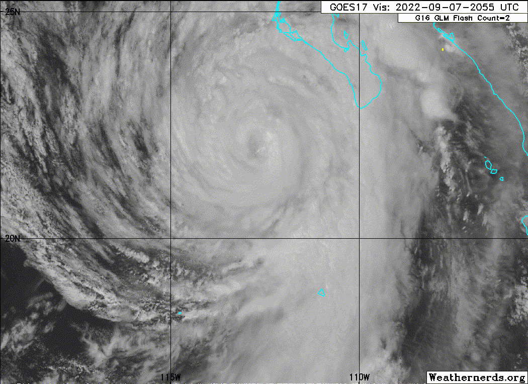
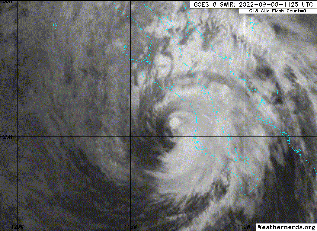
The satellite presentation of Kay has gradually degraded overnight
with the eye becoming less defined, and the deepest convection
confined to the southeastern and eastern portions of the
circulation. An Air Force Reserve reconnaissance aircraft that
investigated Kay overnight has measured peak 700-mb flight-level
winds of 78 kt. Unfortunately the SFMR data appeared
unrepresentative as compared to corresponding dropsonde surface
winds and recent scatterometer data. As a result, there is higher
uncertainty in how much the flight-level winds are mixing to the
surface. The initial intensity has been conservatively reduced to
75 kt, which is a blend of the flight-level reduced winds, and
recent satellite intensity estimates. The aircraft reported a
minimum pressure of 974 mb on its final pass through the center.

Kay has crossed the 26 degree Celsius isotherm and will be
traversing progressively cooler SSTs over the next couple of days.
That, along with a gradually drying mid-level air mass, is expected
to cause gradual weakening over the next couple of days. However,
Kay is forecast to remain a hurricane when it passes near or over
the west-central coast of the Baja California peninsula later
today, and remain a tropical storm as it passes just west of the
northwestern portion of the peninsula on Friday. Simulated
satellite imagery from the global models suggest the convection
will wane on Saturday, and Kay is forecast to become post-tropical
at that time. The new NHC intensity forecast calls for slightly
faster rate of weakening than before, and is near the IVCN and HCCA
consensus aids.

Kay continues to move north-northwestward or 345/12 kt. A mid-level
ridge to the east of Kay should steer it on a north-northwestward
heading during the next 24 to 36 hours. After that time, a weaker
and more vertically shallow Kay is expected to turn more westward,
and eventually southward to the southeast of a low-level ridge over
the eastern Pacific. The NHC track forecast lies near the HFIP
corrected consensus model, and is quite similar to the previous
official forecast.

Kay is a very large tropical cyclone. It is producing an extensive
area of high seas, with swells affecting portions of southwestern
Mexico, the Gulf of California, and the Baja California peninsula.
Although Kay is likely to weaken before it makes landfall or moves
very close to the west-central coast of the Baja peninsula, it is
forecast to remain a large and dangerous hurricane through that
time. In addition, high wind, surf, and rainfall impacts will
extend far from the center so users should not focus on the exact
forecast track.

KEY MESSAGES:

1. As the center of Kay passes near or over the Baja California
peninsula, heavy rainfall could lead to flash flooding, including
landslides, across the Baja California peninsula and portions of
mainland northwestern Mexico through Saturday morning. Flash,
urban, and small stream flooding is possible across Southern
California, especially in and near the peninsular ranges, and
Southwest Arizona, Friday into Saturday.

2. Hurricane conditions are expected along portions of the
west-central Baja California coast later this morning through
this evening, and a hurricane warning is in effect for that area.

3. Tropical storm conditions are occurring over portions of the
Baja California peninsula, and these conditions are expected
to spread northward during the next day or so, where a
Tropical Storm Warning is in effect.


FORECAST POSITIONS AND MAX WINDS

INIT 08/0900Z 24.5N 113.4W 75 KT 85 MPH
12H 08/1800Z 26.5N 114.1W 65 KT 75 MPH
24H 09/0600Z 28.7N 115.4W 55 KT 65 MPH
36H 09/1800Z 30.5N 116.8W 45 KT 50 MPH
48H 10/0600Z 31.4N 118.4W 40 KT 45 MPH
60H 10/1800Z 31.7N 119.5W 35 KT 40 MPH...POST-TROPICAL
72H 11/0600Z 31.7N 120.4W 30 KT 35 MPH...POST-TROP/REMNT LOW
96H 12/0600Z 30.3N 120.9W 20 KT 25 MPH...POST-TROP/REMNT LOW
120H 13/0600Z 28.7N 120.0W 15 KT 15 MPH...POST-TROP/REMNT LOW

$$
Forecaster Brown
0 likes   
Visit the Caribbean-Central America Weather Thread where you can find at first post web cams,radars
and observations from Caribbean basin members Click Here

Sciencerocks
Category 5
Category 5
Posts: 7282
Age: 38
Joined: Thu Jul 06, 2017 1:51 am

Re: EPAC: KAY - Hurricane

#157 Postby Sciencerocks » Thu Sep 08, 2022 9:52 am

Image
0 likes   

User avatar
cycloneye
Admin
Admin
Posts: 139019
Age: 67
Joined: Thu Oct 10, 2002 10:54 am
Location: San Juan, Puerto Rico

Re: EPAC: KAY - Hurricane

#158 Postby cycloneye » Thu Sep 08, 2022 9:54 am

Hurricane Kay Discussion Number 17
NWS National Hurricane Center Miami FL EP122022
900 AM MDT Thu Sep 08 2022

Kay continues to lose organization in satellite imagery, as there
is no longer an eye present and the central convection continues to
decrease. The various subjective and objective satellite intensity
estimates are in the 65-77 kt range, and based on this the initial
intensity is held at a possibly generous 75 kt. An Air Force
Reserve Hurricane Hunter aircraft is currently enroute to
investigate Kay.

Kay is now over 23C sea surface temperatures and will be traversing
progressively cooler SSTs over the next couple of days. That,
along with land interaction and a gradually drying mid-level air
mass, is expected to cause gradual weakening over the next couple of
days. However, Kay is forecast to remain a hurricane when it passes
near or over the west-central coast of the Baja California peninsula
in about 12 h, and remain a tropical storm as it passes just west
of the northwestern portion of the peninsula on Friday. The cyclone
is expected to lose its convection and become post-tropical between
48-60 h, and then decay to a remnant low pressure area by 72 h.

Kay continues to move north-northwestward or 345/13 kt. There is no
change to the previous track forecast philosophy. A mid-level
ridge to the east of Kay should steer it on a north-northwestward
heading during the next 24 to 36 hours. After that time, a weaker
and more vertically shallow Kay is expected to turn more westward,
and eventually southward to the southeast of a low-level ridge over
the eastern Pacific. The track guidance has changed little since
the last advisory, so the new track forecast has only minor
adjustments from the previous forecast.

Kay remains a very large tropical cyclone. It is producing an
extensive area of high seas, with swells affecting portions of
southwestern Mexico, the Gulf of California, and the Baja California
peninsula. Although Kay is likely to weaken before it makes
landfall or moves very close to the west-central coast of the Baja
peninsula, it is forecast to remain a large and dangerous hurricane
through that time. In addition, high wind, surf, and rainfall
impacts will extend far from the center so users should not focus on
the exact forecast track.

KEY MESSAGES:

1. As the center of Kay passes just offshore, heavy rainfall could
lead to flash flooding, including landslides, across the Baja
California peninsula and portions of mainland northwestern Mexico
through Saturday morning. Flash, urban, and small stream flooding
is likely across Southern California beginning Friday, especially in
and near the peninsular ranges. Flash, urban, and small stream
flooding is possible beginning Friday in Southwest Arizona.

2. Hurricane conditions are expected along portions of the
west-central Baja California coast later this morning through
this evening, and a hurricane warning is in effect for that area.

3. Tropical storm conditions are occurring over portions of the
Baja California peninsula, and these conditions are expected
to spread northward during the next day or so, where a
Tropical Storm Warning is in effect.


FORECAST POSITIONS AND MAX WINDS

INIT 08/1500Z 25.8N 113.8W 75 KT 85 MPH
12H 09/0000Z 27.6N 114.6W 65 KT 75 MPH...INLAND
24H 09/1200Z 29.6N 116.0W 55 KT 65 MPH...OVER WATER
36H 10/0000Z 30.9N 117.5W 45 KT 50 MPH
48H 10/1200Z 31.5N 118.9W 40 KT 45 MPH
60H 11/0000Z 31.7N 119.9W 35 KT 40 MPH...POST-TROPICAL
72H 11/1200Z 31.3N 120.8W 30 KT 35 MPH...POST-TROP/REMNT LOW
96H 12/1200Z 30.0N 121.0W 20 KT 25 MPH...POST-TROP/REMNT LOW
120H 13/1200Z 28.5N 120.0W 20 KT 25 MPH...POST-TROP/REMNT LOW

$$
Forecaster Beven
0 likes   
Visit the Caribbean-Central America Weather Thread where you can find at first post web cams,radars
and observations from Caribbean basin members Click Here

User avatar
wxman57
Moderator-Pro Met
Moderator-Pro Met
Posts: 22480
Age: 66
Joined: Sat Jun 21, 2003 8:06 pm
Location: Houston, TX (southwest)

Re: EPAC: KAY - Hurricane

#159 Postby wxman57 » Thu Sep 08, 2022 12:28 pm

The cool water has taken its toll on Kay. Recon finding a tropical storm. It will weaken more quickly than predicted over 21C water.
2 likes   

zeehag
Tropical Storm
Tropical Storm
Posts: 172
Age: 75
Joined: Sun Jul 17, 2011 9:49 pm
Location: mazatlan,sinaloa, mexico, fixing patricia's mess.
Contact:

Re: EPAC: KAY - Hurricane

#160 Postby zeehag » Thu Sep 08, 2022 3:51 pm

our local sites are calling this kay a cat 3, but i think they are overestimating.. cold water doesnot a 3 make. san diegans are crying they are to get a hurricane which makes me laugh as the water is too cold to support that mess. no one in waters of la paz area or cabos area was hurt more than lost canvas which should havebeen removed anyway.(boaters new to canes forget) .. roads are washed out and bridges undermined--typical of mexican flooding and tormentas tropicales in baja. i havenot yet received reports from land dwellers.
0 likes   
life is an adventure meant to be LIVED!!!

http://www.sksolitarybird.org


Return to “2022”

Who is online

Users browsing this forum: No registered users and 22 guests