WPAC: NANMADOL - Post-Tropical

Moderator: S2k Moderators

Message
Author
User avatar
doomhaMwx
Category 5
Category 5
Posts: 2398
Age: 25
Joined: Tue Apr 18, 2017 4:01 am
Location: Baguio/Benguet, Philippines
Contact:

Re: WPAC: NANMADOL - Typhoon

#21 Postby doomhaMwx » Thu Sep 15, 2022 8:10 am

16W NANMADOL 220915 1200 23.4N 137.3E WPAC 70 970

T2214(Nanmadol)
Issued at 2022/09/15 12:50 UTC
Analysis at 09/15 12 UTC
Grade TY
Scale Large
Intensity -
Center position N23°25′ (23.4°)
E137°20′ (137.3°)
Direction and speed of movement W 15 km/h (7 kt)
Central pressure 970 hPa
Maximum sustained wind speed near center 35 m/s (65 kt)
Maximum wind gust speed 50 m/s (95 kt)
Radius of 50-kt wind area 130 km (70 NM)
Radius of 30-kt wind area 600 km (325 NM)
0 likes   
Like my content? Consider giving a tip.

User avatar
aspen
Category 5
Category 5
Posts: 8056
Joined: Sat Oct 12, 2019 7:10 pm
Location: Connecticut, USA

Re: WPAC: NANMADOL - Typhoon

#22 Postby aspen » Thu Sep 15, 2022 9:12 am

Dual <-80C hot towers are rotating around the core. Looks like RI has begun, and this could end up as a major within the next 24 hours.
Image
0 likes   
Irene '11 Sandy '12 Hermine '16 5/15/2018 Derecho Fay '20 Isaias '20 Elsa '21 Henri '21 Ida '21

I am only a meteorology enthusiast who knows a decent amount about tropical cyclones. Look to the professional mets, the NHC, or your local weather office for the best information.

User avatar
ElectricStorm
Category 5
Category 5
Posts: 4525
Age: 23
Joined: Tue Aug 13, 2019 11:23 pm
Location: Skiatook, OK / Norman, OK

Re: WPAC: NANMADOL - Typhoon

#23 Postby ElectricStorm » Thu Sep 15, 2022 10:45 am

I'm thinking this has potential to make a Cat 5 run. Already has very impressive convection, if it can pop an eye out of that it's off to the races. Current JTWC peak is 120kts but I think this could easily get stronger than that. Maybe 130-140kt peak
0 likes   
I am in no way a professional. Take what I say with a grain of salt as I could be totally wrong. Please refer to the NHC, NWS, or SPC for official information.

Boomer Sooner!

User avatar
aspen
Category 5
Category 5
Posts: 8056
Joined: Sat Oct 12, 2019 7:10 pm
Location: Connecticut, USA

Re: WPAC: NANMADOL - Typhoon

#24 Postby aspen » Thu Sep 15, 2022 3:28 pm

Probably near or at MH intensity now (95-105 kt). I think this has potential to exceed Hinnamnor's peak in the coming days.
Image
0 likes   
Irene '11 Sandy '12 Hermine '16 5/15/2018 Derecho Fay '20 Isaias '20 Elsa '21 Henri '21 Ida '21

I am only a meteorology enthusiast who knows a decent amount about tropical cyclones. Look to the professional mets, the NHC, or your local weather office for the best information.

Subtrop
Category 1
Category 1
Posts: 448
Joined: Sun Feb 21, 2021 9:45 pm

Re: WPAC: NANMADOL - Typhoon

#25 Postby Subtrop » Thu Sep 15, 2022 4:56 pm

TPPN11 PGTW 152124

A. TYPHOON 16W (NANMADOL)

B. 15/2040Z

C. 23.49N

D. 136.11E

E. ONE/HMWRI8

F. T6.5/6.5/D3.0/24HRS STT: D1.5/03HRS

G. IR/EIR

H. REMARKS: 05A/PBO IRREG EYE/ANMTN. OW EYE SURROUNDED BY W YIELDS
AN E# OF 6.0. ADDED 0.5 EYE ADJUSTMENT FOR W, TO YIELD A DT OF
6.5. MET YIELDS 5.0. PT AGREES WITH DT. DBO DT. CONSTRAINTS BROKEN
DUE TO RAPIDLY DEVELOPING AND WELL DEFINED EYE.

I. ADDITIONAL POSITIONS:
15/1617Z 23.33N 136.52E AMS2
15/1837Z 23.40N 136.38E GPMI


HEINS
0 likes   

User avatar
doomhaMwx
Category 5
Category 5
Posts: 2398
Age: 25
Joined: Tue Apr 18, 2017 4:01 am
Location: Baguio/Benguet, Philippines
Contact:

Re: WPAC: NANMADOL - Typhoon

#26 Postby doomhaMwx » Thu Sep 15, 2022 7:49 pm

Subtrop wrote:
TPPN11 PGTW 152124

A. TYPHOON 16W (NANMADOL)

B. 15/2040Z

C. 23.49N

D. 136.11E

E. ONE/HMWRI8

F. T6.5/6.5/D3.0/24HRS STT: D1.5/03HRS

G. IR/EIR

H. REMARKS: 05A/PBO IRREG EYE/ANMTN. OW EYE SURROUNDED BY W YIELDS
AN E# OF 6.0. ADDED 0.5 EYE ADJUSTMENT FOR W, TO YIELD A DT OF
6.5. MET YIELDS 5.0. PT AGREES WITH DT. DBO DT. CONSTRAINTS BROKEN
DUE TO RAPIDLY DEVELOPING AND WELL DEFINED EYE.

I. ADDITIONAL POSITIONS:
15/1617Z 23.33N 136.52E AMS2
15/1837Z 23.40N 136.38E GPMI


HEINS

Wow, that's aggressive on their part.
0 likes   
Like my content? Consider giving a tip.

User avatar
Iceresistance
Category 5
Category 5
Posts: 8911
Age: 20
Joined: Sat Oct 10, 2020 9:45 am
Location: Tecumseh, OK/Norman, OK

Re: WPAC: NANMADOL - Typhoon

#27 Postby Iceresistance » Thu Sep 15, 2022 8:13 pm

Raw T# at 6.

UW - CIMSS
ADVANCED DVORAK TECHNIQUE
ADT-Version 9.0
Tropical Cyclone Intensity Algorithm

----- Current Analysis -----
Date : 16 SEP 2022 Time : 000000 UTC
Lat : 23:49:11 N Lon : 135:53:59 E


CI# /Pressure/ Vmax
5.8 / 942mb / 110kts


Final T# Adj T# Raw T#
5.8 5.9 6.0

Estimated radius of max. wind based on IR : 22 km

Center Temp : +10.2C Cloud Region Temp : -68.6C
0 likes   
Bill 2015 & Beta 2020

Winter 2020-2021 :cold:

All observations are in Tecumseh, OK unless otherwise noted.

Winter posts are focused mainly for Oklahoma & Texas.

Take any of my forecasts with a grain of salt, refer to the NWS, SPC, and NHC for official information

Never say Never with weather! Because ANYTHING is possible!

User avatar
doomhaMwx
Category 5
Category 5
Posts: 2398
Age: 25
Joined: Tue Apr 18, 2017 4:01 am
Location: Baguio/Benguet, Philippines
Contact:

Re: WPAC: NANMADOL - Typhoon

#28 Postby doomhaMwx » Thu Sep 15, 2022 8:20 pm

16W NANMADOL 220916 0000 23.8N 135.8E WPAC 110 950

110kts looks to be a good estimate.

Image
0 likes   
Like my content? Consider giving a tip.

User avatar
Hayabusa
Category 5
Category 5
Posts: 3737
Joined: Sun Sep 16, 2018 1:05 pm

Re: WPAC: NANMADOL - Typhoon

#29 Postby Hayabusa » Thu Sep 15, 2022 11:42 pm

This may surpass or at least match Hinnamnor's 140 kt peak.
0 likes   
ヤンデレ女が寝取られるているのを見たい!!!
ECMWF ensemble NWPAC plots: https://ecmwfensnwpac.imgbb.com/
Multimodel NWPAC plots: https://multimodelnwpac.imgbb.com/
GFS Ensemble NWPAC plots (16 & 35 day forecast): https://gefsnwpac.imgbb.com/
Plots updated automatically

User avatar
doomhaMwx
Category 5
Category 5
Posts: 2398
Age: 25
Joined: Tue Apr 18, 2017 4:01 am
Location: Baguio/Benguet, Philippines
Contact:

Re: WPAC: NANMADOL - Typhoon

#30 Postby doomhaMwx » Fri Sep 16, 2022 12:07 am

Japan has sent recon into Nanmadol!

 https://twitter.com/TRCatYNU/status/1570624729463296000


[TRC Bulletin]
Kazuhisa Tsuboki, Deputy Director of TRC and Director of Typhoon Observation Research Lab, just took off for direct observation of Typhoon No. 14 by aircraft.
1 likes   
Like my content? Consider giving a tip.

User avatar
Hayabusa
Category 5
Category 5
Posts: 3737
Joined: Sun Sep 16, 2018 1:05 pm

Re: WPAC: NANMADOL - Typhoon

#31 Postby Hayabusa » Fri Sep 16, 2022 12:23 am

Imran_doomhaMwx wrote:Japan has sent recon into Nanmadol!

https://twitter.com/TRCatYNU/status/1570624729463296000
[TRC Bulletin]
Kazuhisa Tsuboki, Deputy Director of TRC and Director of Typhoon Observation Research Lab, just took off for direct observation of Typhoon No. 14 by aircraft.

They refused to do for Hinnamnor but it was a Korean landfall in the end :P
0 likes   
ヤンデレ女が寝取られるているのを見たい!!!
ECMWF ensemble NWPAC plots: https://ecmwfensnwpac.imgbb.com/
Multimodel NWPAC plots: https://multimodelnwpac.imgbb.com/
GFS Ensemble NWPAC plots (16 & 35 day forecast): https://gefsnwpac.imgbb.com/
Plots updated automatically

User avatar
doomhaMwx
Category 5
Category 5
Posts: 2398
Age: 25
Joined: Tue Apr 18, 2017 4:01 am
Location: Baguio/Benguet, Philippines
Contact:

Re: WPAC: NANMADOL - Typhoon

#32 Postby doomhaMwx » Fri Sep 16, 2022 1:52 am

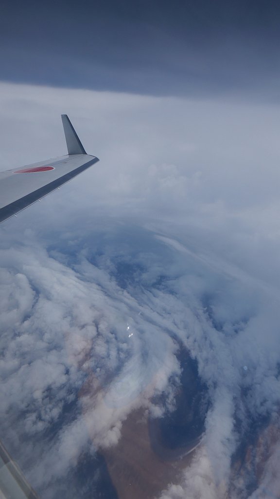
Inside the eye, taken from Japan's recon aircraft.

Image
 https://twitter.com/met_rq/status/1570661328033034241


4 likes   
Like my content? Consider giving a tip.

User avatar
doomhaMwx
Category 5
Category 5
Posts: 2398
Age: 25
Joined: Tue Apr 18, 2017 4:01 am
Location: Baguio/Benguet, Philippines
Contact:

Re: WPAC: NANMADOL - Typhoon

#33 Postby doomhaMwx » Fri Sep 16, 2022 4:20 am

16W NANMADOL 220916 0600 24.2N 135.3E WPAC 115 935

T2214(Nanmadol)
Issued at 2022/09/16 06:50 UTC
Analysis at 09/16 06 UTC
Grade TY
Scale Large
Intensity Very Strong
Center position N24°10′ (24.2°)
E135°30′ (135.5°)
Direction and speed of movement NW 15 km/h (7 kt)
Central pressure 950 hPa
Maximum sustained wind speed near center 45 m/s (85 kt)
Maximum wind gust speed 60 m/s (120 kt)
Radius of 50-kt wind area 185 km (100 NM)
Radius of 30-kt wind area E650 km (350 NM)
W560 km (300 NM)


Looking really good now. The eye has become more symmetric and clearer, and the CDO looks smoother with cooling cloud tops. It has likely strengthened more after Japan's recon mission a few hours ago.

Image
Image
3 likes   
Like my content? Consider giving a tip.

User avatar
doomhaMwx
Category 5
Category 5
Posts: 2398
Age: 25
Joined: Tue Apr 18, 2017 4:01 am
Location: Baguio/Benguet, Philippines
Contact:

Re: WPAC: NANMADOL - Typhoon

#34 Postby doomhaMwx » Fri Sep 16, 2022 5:17 am

According to this article, the central pressure measured from today's recon mission was 940mb at around 06Z (lower than JMA's 06Z estimate of 950mb).
https://news.yahoo.co.jp/articles/74d06 ... 02498b1712
0 likes   
Like my content? Consider giving a tip.

User avatar
aspen
Category 5
Category 5
Posts: 8056
Joined: Sat Oct 12, 2019 7:10 pm
Location: Connecticut, USA

Re: WPAC: NANMADOL - Typhoon

#35 Postby aspen » Fri Sep 16, 2022 7:52 am

Imran_doomhaMwx wrote:According to this article, the central pressure measured from today's recon mission was 940mb at around 06Z (lower than JMA's 06Z estimate of 950mb).
https://news.yahoo.co.jp/articles/74d06 ... 02498b1712

The JTWC’s 12z estimate is 130kt/920mbar. Did recon support high-end Cat 4 winds and a deepening rate that wild get it this low?
0 likes   
Irene '11 Sandy '12 Hermine '16 5/15/2018 Derecho Fay '20 Isaias '20 Elsa '21 Henri '21 Ida '21

I am only a meteorology enthusiast who knows a decent amount about tropical cyclones. Look to the professional mets, the NHC, or your local weather office for the best information.

User avatar
Hayabusa
Category 5
Category 5
Posts: 3737
Joined: Sun Sep 16, 2018 1:05 pm

Re: WPAC: NANMADOL - Typhoon

#36 Postby Hayabusa » Fri Sep 16, 2022 7:53 am

Guess that recon was helpful
T2214(Nanmadol)
Issued at 2022/09/16 12:45 UTC
Analysis at 09/16 12 UTC
Grade TY
Scale Large
Intensity Very Strong
Center position N24°55′ (24.9°)
E134°40′ (134.7°)
Direction and speed of movement NW 15 km/h (8 kt)
Central pressure 925 hPa
Maximum sustained wind speed near center 50 m/s (95 kt)
Maximum wind gust speed 70 m/s (135 kt)
Radius of 50-kt wind area 185 km (100 NM)
Radius of 30-kt wind area E650 km (350 NM)
W560 km (300 NM)
Estimate for 09/16 13 UTC
Grade TY
Scale Large
Intensity Very Strong
Center position N25°00′ (25.0°)
E134°35′ (134.6°)
Direction and speed of movement NW 15 km/h (8 kt)
Central pressure 925 hPa
Maximum sustained wind speed near center 50 m/s (95 kt)
Maximum wind gust speed 70 m/s (135 kt)
Radius of storm warning area 185 km (100 NM)
Radius of 30-kt wind area E650 km (350 NM)
W560 km (300 NM)
Forecast for 09/17 00 UTC
Grade TY
Intensity Very Strong
Center position of probability circle N26°20′ (26.3°)
E132°50′ (132.8°)
Direction and speed of movement NW 20 km/h (11 kt)
Central pressure 925 hPa
Maximum sustained wind speed near center 50 m/s (95 kt)
Maximum wind gust speed 70 m/s (135 kt)
Radius of probability circle 45 km (25 NM)
Radius of storm warning area 270 km (145 NM)
Forecast for 09/17 12 UTC
Grade TY
Intensity Very Strong
Center position of probability circle N27°55′ (27.9°)
E131°30′ (131.5°)
Direction and speed of movement NW 20 km/h (10 kt)
Central pressure 925 hPa
Maximum sustained wind speed near center 50 m/s (95 kt)
Maximum wind gust speed 70 m/s (135 kt)
Radius of probability circle 65 km (35 NM)
Radius of storm warning area 290 km (155 NM)
Forecast for 09/18 12 UTC
Grade TY
Intensity Very Strong
Center position of probability circle N32°35′ (32.6°)
E129°40′ (129.7°)
Direction and speed of movement NNW 20 km/h (12 kt)
Central pressure 945 hPa
Maximum sustained wind speed near center 45 m/s (85 kt)
Maximum wind gust speed 60 m/s (120 kt)
Radius of probability circle 110 km (60 NM)
Radius of storm warning area 330 km (180 NM)
Forecast for 09/19 12 UTC
Grade TY
Intensity -
Center position of probability circle N35°50′ (35.8°)
E134°30′ (134.5°)
Direction and speed of movement NE 25 km/h (13 kt)
Central pressure 970 hPa
Maximum sustained wind speed near center 35 m/s (65 kt)
Maximum wind gust speed 50 m/s (95 kt)
Radius of probability circle 260 km (140 NM)
Radius of storm warning area 480 km (260 NM)
Forecast for 09/20 12 UTC
Grade LOW
Intensity -
Center position of probability circle N40°40′ (40.7°)
E145°10′ (145.2°)
Direction and speed of movement ENE 45 km/h (24 kt)
Central pressure 990 hPa
Maximum wind speed 23 m/s (45 kt)
Maximum wind gust speed 35 m/s (65 kt)
Radius of probability circle 480 km (260 NM)
0 likes   
ヤンデレ女が寝取られるているのを見たい!!!
ECMWF ensemble NWPAC plots: https://ecmwfensnwpac.imgbb.com/
Multimodel NWPAC plots: https://multimodelnwpac.imgbb.com/
GFS Ensemble NWPAC plots (16 & 35 day forecast): https://gefsnwpac.imgbb.com/
Plots updated automatically

User avatar
mrbagyo
Category 5
Category 5
Posts: 3614
Age: 31
Joined: Thu Apr 12, 2012 9:18 am
Location: 14.13N 120.98E
Contact:

Re: WPAC: NANMADOL - Typhoon

#37 Postby mrbagyo » Fri Sep 16, 2022 8:29 am

Imran_doomhaMwx wrote:According to this article, the central pressure measured from today's recon mission was 940mb at around 06Z (lower than JMA's 06Z estimate of 950mb).
https://news.yahoo.co.jp/articles/74d06 ... 02498b1712


940 seems inaccurate - possible miscommunication happened.

JMA went with 945 hPa on their latest warning equipped with the recon data.
0 likes   
The posts in this forum are NOT official forecast and should not be used as such. They are just the opinion of the poster and may or may not be backed by sound meteorological data. They are NOT endorsed by any professional institution or storm2k.org. For official information, please refer to RSMC, NHC and NWS products.

User avatar
doomhaMwx
Category 5
Category 5
Posts: 2398
Age: 25
Joined: Tue Apr 18, 2017 4:01 am
Location: Baguio/Benguet, Philippines
Contact:

Re: WPAC: NANMADOL - Typhoon

#38 Postby doomhaMwx » Fri Sep 16, 2022 8:41 am

mrbagyo wrote:
Imran_doomhaMwx wrote:According to this article, the central pressure measured from today's recon mission was 940mb at around 06Z (lower than JMA's 06Z estimate of 950mb).
https://news.yahoo.co.jp/articles/74d06 ... 02498b1712


940 seems inaccurate - possible miscommunication happened.

JMA went with 945 hPa on their latest warning equipped with the recon data.

Yeah, I was just reading a discussion about it that the dropsonde data would actually translate to ~945mb SLP (which explains the 09Z JMA estimate).
UZPQ10 RJTD 160456

XXAA 66043 99241 11357 09545 99/// ///// ///// 00/// /////

///// 92190 25610 12043 85925 23015 12542 70608 17250 14038

50544 04457 15531 40760 04957 16022 30010 16163 16522 88999

77999 31313 03608 80456=

^ I still need to learn to decode this myself though. :lol:
0 likes   
Like my content? Consider giving a tip.

User avatar
doomhaMwx
Category 5
Category 5
Posts: 2398
Age: 25
Joined: Tue Apr 18, 2017 4:01 am
Location: Baguio/Benguet, Philippines
Contact:

Re: WPAC: NANMADOL - Typhoon

#39 Postby doomhaMwx » Fri Sep 16, 2022 9:04 am

Direct ASCAT pass over Nanmadol this evening nicely captures the system's massive wind field.

Image
1 likes   
Like my content? Consider giving a tip.

User avatar
Hayabusa
Category 5
Category 5
Posts: 3737
Joined: Sun Sep 16, 2018 1:05 pm

Re: WPAC: NANMADOL - Typhoon

#40 Postby Hayabusa » Fri Sep 16, 2022 9:44 am

2022SEP16 141000 6.7 920 132 6.7 7.0 7.0 NO LIMIT OFF OFF OFF OFF 20.60 -75.14 EYE 21 IR 65.9 25.14 -134.31 ARCHER HIM-8 30.2
0 likes   
ヤンデレ女が寝取られるているのを見たい!!!
ECMWF ensemble NWPAC plots: https://ecmwfensnwpac.imgbb.com/
Multimodel NWPAC plots: https://multimodelnwpac.imgbb.com/
GFS Ensemble NWPAC plots (16 & 35 day forecast): https://gefsnwpac.imgbb.com/
Plots updated automatically


Return to “2022”

Who is online

Users browsing this forum: No registered users and 22 guests