ATL: Ex INVEST 95L - Discussion

Moderator: S2k Moderators

Message
Author
Subtrop
Category 1
Category 1
Posts: 448
Joined: Sun Feb 21, 2021 9:45 pm

ATL: Ex INVEST 95L - Discussion

#1 Postby Subtrop » Tue Sep 06, 2022 11:42 pm

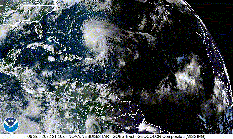
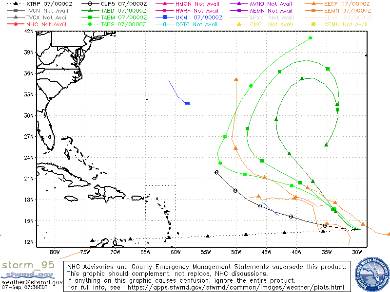
AL, 95, 2022090618, , BEST, 0, 138N, 276W, 25, 1012, DB, 0, , 0, 0, 0, 0, 1013, 200, 90, 0, 0, L, 0, , 0, 0, GENESIS024, , 0, , 0, 0, 0, 0, genesis-num, 024, SPAWNINVEST, al762022 to al952022,
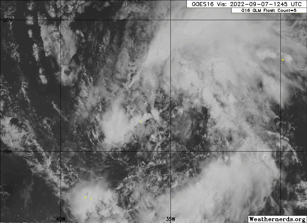
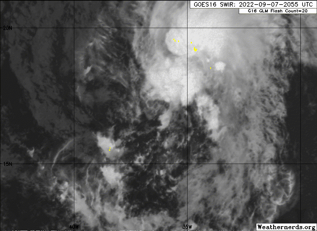
AL, 95, 2022090700, , BEST, 0, 137N, 293W, 25, 1012, DB, 34, NEQ, 0, 0, 0, 0, 1013, 200, 90, 0, 0, L, 0, , 0, 0, INVEST, S, 0, , 0, 0, 0, 0, genesis-num, 024,


https://ftp.nhc.noaa.gov/atcf/btk/
2 likes   

User avatar
ElectricStorm
Category 5
Category 5
Posts: 4523
Age: 23
Joined: Tue Aug 13, 2019 11:23 pm
Location: Skiatook, OK / Norman, OK

Re: ATL: INVEST 95L - Discussion

#2 Postby ElectricStorm » Tue Sep 06, 2022 11:52 pm

I was wondering when they were going to tag this. Should be an easy recurve, but models aren't really doing much with it. I could see this briefly spinning up though, maybe it can become Fiona.
0 likes   
I am in no way a professional. Take what I say with a grain of salt as I could be totally wrong. Please refer to the NHC, NWS, or SPC for official information.

Boomer Sooner!

User avatar
Hammy
Category 5
Category 5
Posts: 5594
Age: 40
Joined: Fri May 25, 2012 5:25 pm
Contact:

Re: ATL: INVEST 95L - Discussion

#3 Postby Hammy » Wed Sep 07, 2022 1:39 am

Tagged as an invest and models immediately start backing off :lol:
3 likes   
The above post is not official and should not be used as such. It is the opinion of the poster and may or may not be backed by sound meteorological data. It is not endorsed by any professional institution or storm2k.org. For official information, please refer to the NHC and NWS products.

Sciencerocks
Category 5
Category 5
Posts: 7282
Age: 38
Joined: Thu Jul 06, 2017 1:51 am

Re: ATL: INVEST 95L - Discussion

#4 Postby Sciencerocks » Wed Sep 07, 2022 1:50 am

Image
0 likes   

User avatar
tropicwatch
Category 5
Category 5
Posts: 3205
Age: 60
Joined: Sat Jun 02, 2007 10:01 am
Location: Panama City Florida
Contact:

Re: ATL: INVEST 95L - Discussion

#5 Postby tropicwatch » Wed Sep 07, 2022 6:52 am

Another one to roam the Atlantic.

Image
0 likes   
Tropicwatch


Agnes 72', Eloise 75, Elena 85', Kate 85', Charley 86', Florence 88', Beryl 94', Dean 95', Erin 95', Opal 95', Earl 98', Georges 98', Ivan 2004', Arlene 2005', Dennis 2005', Ida 2009' Debby 2012' Irma 2017' Michael 2018'

User avatar
Emmett_Brown
Category 5
Category 5
Posts: 1343
Joined: Wed Aug 24, 2005 9:10 pm
Location: Sarasota FL

Re: ATL: INVEST 95L - Discussion

#6 Postby Emmett_Brown » Wed Sep 07, 2022 10:13 am

When you step back from the screen and look at the whole Atlantic ocean visible image, 95L is a large system with nice symmetry. Models don't seem to like it much, and the board members are kind of brushing it off, but I am now a fan, I like the look of this system. I expect it to over perform. Go 95L!
7 likes   

Sciencerocks
Category 5
Category 5
Posts: 7282
Age: 38
Joined: Thu Jul 06, 2017 1:51 am

Re: ATL: INVEST 95L - Discussion

#7 Postby Sciencerocks » Wed Sep 07, 2022 11:18 am

Image
1 likes   

User avatar
cycloneye
Admin
Admin
Posts: 139025
Age: 67
Joined: Thu Oct 10, 2002 10:54 am
Location: San Juan, Puerto Rico

Re: ATL: INVEST 95L - Discussion

#8 Postby cycloneye » Wed Sep 07, 2022 1:03 pm

1. Eastern Tropical Atlantic:
Satellite imagery indicates that the area of low pressure located
several hundred miles west of the Cabo Verde Islands is gradually
becoming better defined. However, the associated shower and
thunderstorm activity still remains disorganized. Environmental
conditions appear conducive for additional development of this
system over the next day or two, and a tropical depression is likely
form by Friday while it moves westward to west-northwestward at 15
to 20 mph over the eastern and central tropical Atlantic. After
that time, upper-level winds are forecast to become less conducive
for development.
* Formation chance through 48 hours...high...70 percent.
* Formation chance through 5 days...high...70 percent.
0 likes   
Visit the Caribbean-Central America Weather Thread where you can find at first post web cams,radars
and observations from Caribbean basin members Click Here

User avatar
wxman57
Moderator-Pro Met
Moderator-Pro Met
Posts: 22480
Age: 66
Joined: Sat Jun 21, 2003 8:06 pm
Location: Houston, TX (southwest)

Re: ATL: INVEST 95L - Discussion

#9 Postby wxman57 » Wed Sep 07, 2022 3:23 pm

Models indicate slow weakening by tomorrow. Could be classified as a TD by the NHC this hour. Won't be around long. Looking like a subtropical Atlantic season.
2 likes   

User avatar
aspen
Category 5
Category 5
Posts: 8056
Joined: Sat Oct 12, 2019 7:10 pm
Location: Connecticut, USA

Re: ATL: INVEST 95L - Discussion

#10 Postby aspen » Wed Sep 07, 2022 7:01 pm

One of the better looking waves this year. Seems to be close to becoming a TD, but we'll need ASCAT to confirm.
Image
3 likes   
Irene '11 Sandy '12 Hermine '16 5/15/2018 Derecho Fay '20 Isaias '20 Elsa '21 Henri '21 Ida '21

I am only a meteorology enthusiast who knows a decent amount about tropical cyclones. Look to the professional mets, the NHC, or your local weather office for the best information.

Sciencerocks
Category 5
Category 5
Posts: 7282
Age: 38
Joined: Thu Jul 06, 2017 1:51 am

Re: ATL: INVEST 95L - Discussion

#11 Postby Sciencerocks » Wed Sep 07, 2022 7:19 pm

Image
1 likes   

User avatar
Hammy
Category 5
Category 5
Posts: 5594
Age: 40
Joined: Fri May 25, 2012 5:25 pm
Contact:

Re: ATL: INVEST 95L - Discussion

#12 Postby Hammy » Thu Sep 08, 2022 2:03 am

Image

About as close as this will get to developing. NHC has it at 70% and BT still has a disturbance, all but guaranteeing it won't get upgraded before it runs out of time later today.
0 likes   
The above post is not official and should not be used as such. It is the opinion of the poster and may or may not be backed by sound meteorological data. It is not endorsed by any professional institution or storm2k.org. For official information, please refer to the NHC and NWS products.

User avatar
Nimbus
Category 5
Category 5
Posts: 4928
Joined: Mon Jul 19, 2004 10:54 am

Re: ATL: INVEST 95L - Discussion

#13 Postby Nimbus » Thu Sep 08, 2022 5:16 am

Looks like we have a low level center producing white convection near 19-20N.
Should follow Earl out to sea from that latitude so will be less stressful to watch.
0 likes   

User avatar
cycloneye
Admin
Admin
Posts: 139025
Age: 67
Joined: Thu Oct 10, 2002 10:54 am
Location: San Juan, Puerto Rico

Re: ATL: INVEST 95L - Discussion

#14 Postby cycloneye » Thu Sep 08, 2022 6:56 am

1. Eastern Tropical Atlantic:
An area of low pressure located almost a thousand miles west of the
Cabo Verde Islands continues to produce disorganized showers and
thunderstorms. Environmental conditions appear conducive for
additional development of this system, and a tropical depression is
likely to form within the next day or so while it moves westward to
west-northwestward at 15 to 20 mph over the central tropical
Atlantic. After that time, upper-level winds are forecast to become
less conducive for development.
* Formation chance through 48 hours...high...70 percent.
* Formation chance through 5 days...high...70 percent.
0 likes   
Visit the Caribbean-Central America Weather Thread where you can find at first post web cams,radars
and observations from Caribbean basin members Click Here

User avatar
cycloneye
Admin
Admin
Posts: 139025
Age: 67
Joined: Thu Oct 10, 2002 10:54 am
Location: San Juan, Puerto Rico

Re: ATL: INVEST 95L - Discussion

#15 Postby cycloneye » Thu Sep 08, 2022 7:38 am

Very exposed.

Image
0 likes   
Visit the Caribbean-Central America Weather Thread where you can find at first post web cams,radars
and observations from Caribbean basin members Click Here

ChrisH-UK
Category 1
Category 1
Posts: 421
Joined: Sat May 29, 2021 8:22 am

Re: ATL: INVEST 95L - Discussion

#16 Postby ChrisH-UK » Thu Sep 08, 2022 7:43 am

Worrying ly looks like 95L shear is causing problems and the vorticity isn't stacked as well.

Source GOES-16 Geo Colour - https://col.st/Fwnq7

0 likes   

tolakram
Admin
Admin
Posts: 19165
Age: 60
Joined: Sun Aug 27, 2006 8:23 pm
Location: Florence, KY (name is Mark)

Re: ATL: INVEST 95L - Discussion

#17 Postby tolakram » Thu Sep 08, 2022 7:51 am

Shear only gets worse from here. I thought marginal was 20 to 30kts.

Image

source: https://tropic.ssec.wisc.edu/tropic.php# click on the Invest
0 likes   
M a r k
- - - - -
Join us in chat: Storm2K Chatroom Invite. Android and IOS apps also available.

The posts in this forum are NOT official forecasts and should not be used as such. Posts are NOT endorsed by any professional institution or STORM2K.org. For official information and forecasts, please refer to NHC and NWS products.

User avatar
InfernoFlameCat
Category 5
Category 5
Posts: 1966
Age: 21
Joined: Mon Dec 14, 2020 10:52 am
Location: Buford, GA

Re: ATL: INVEST 95L - Discussion

#18 Postby InfernoFlameCat » Thu Sep 08, 2022 10:17 am

This is clearly a tropical depression. Tight swirl with convection
3 likes   
I am by no means a professional. DO NOT look at my forecasts for official information or make decisions based on what I post.

Goal: to become a registered expert over tropical and subtropical cyclones.

Sciencerocks
Category 5
Category 5
Posts: 7282
Age: 38
Joined: Thu Jul 06, 2017 1:51 am

Re: ATL: INVEST 95L - Discussion

#19 Postby Sciencerocks » Thu Sep 08, 2022 10:33 am

Image
0 likes   

AutoPenalti
Category 5
Category 5
Posts: 3949
Age: 27
Joined: Mon Aug 17, 2015 4:16 pm
Location: Ft. Lauderdale, Florida

Re: ATL: INVEST 95L - Discussion

#20 Postby AutoPenalti » Thu Sep 08, 2022 10:52 am

3 likes   
The posts in this forum are NOT official forecasts and should not be used as such. They are just the opinion of the poster and may or may not be backed by sound meteorological data. They are NOT endorsed by any professional institution or STORM2K. For official information, please refer to products from the NHC and NWS.


Model Runs Cheat Sheet:
GFS (5:30 AM/PM, 11:30 AM/PM)
HWRF, GFDL, UKMET, NAVGEM (6:30-8:00 AM/PM, 12:30-2:00 AM/PM)
ECMWF (1:45 AM/PM)

TCVN
is a weighted averaged


Return to “2022”

Who is online

Users browsing this forum: No registered users and 22 guests