ZCZC MIATCDEP4 ALL
TTAA00 KNHC DDHHMM
Tropical Storm Madeline Discussion Number 7
NWS National Hurricane Center Miami FL EP142022
300 AM MDT Mon Sep 19 2022
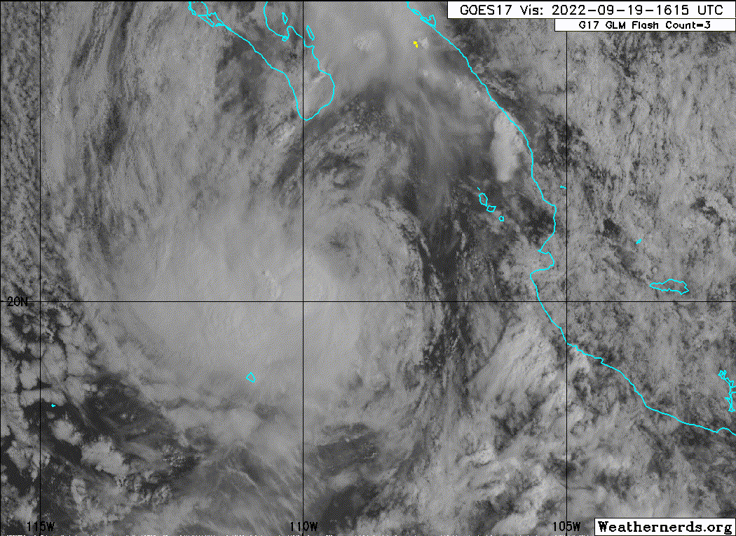
Madeline continues to produce an healthy area of deep convection,
though this activity continues to be somewhat displaced to the
southwest of the center due to moderate northeasterly shear. We
finally received some long awaited scatterometer data at 0357 UTC,
which had a peak wind retrieval of 48-kt in the southern semicircle
of Madeline's circulation. Satellite estimates were also somewhat
higher, with TAFB at T3.5/55-kt, SAB at T3.0/45-kt, and ADT at
T3.2/49-kt. A combination of these intensity estimates support
raising the intensity to 50 kt for this advisory.
Fixes from both scatterometer and microwave data indicate that
Madeline is continuing its northwest heading, estimated at 320/8 kt.
As mid-level ridging builds in to the north, the storm is expected
to turn toward the west-northwest later today and gradually bend
more westward through the end of its lifespan as a tropical cyclone.
While a lot of the guidance continues to be tightly clustered, there
remain a few outliers that are further to the north (HWRF/
Experimental HAFS-S). The latest track forecast was nudged a bit
further north, mostly related to the initial position and motion,
but after 24 hours is very close to the previous forecast track, but
just a touch faster, in agreement with the TVCE and HCCA consensus
aids.
While I cannot rule out that Madeline might intensify a bit more in
the next 6-12 h, the easterly vertical wind shear that has been
plaguing the storm is forecast to increase further later today, as
the storm moves over rapidly cooling sea-surface temperatures,
crossing the 26 C isotherm in about 24 hours. Thus, weakening is
expected to begin by tonight, and simulated satellite imagery
suggests organized deep convection will cease in 36-48 hours, with
the latest forecast still showing Madeline becoming a remnant low by
that time. The latest NHC intensity forecast is in good agreement
with the intensity consensus aids.
FORECAST POSITIONS AND MAX WINDS
INIT 19/0900Z 20.3N 108.2W 50 KT 60 MPH
12H 19/1800Z 20.9N 109.4W 50 KT 60 MPH
24H 20/0600Z 21.4N 110.8W 45 KT 50 MPH
36H 20/1800Z 21.7N 112.1W 35 KT 40 MPH
48H 21/0600Z 21.9N 113.4W 30 KT 35 MPH...POST-TROP/REMNT LOW
60H 21/1800Z 22.0N 114.7W 25 KT 30 MPH...POST-TROP/REMNT LOW
72H 22/0600Z 21.9N 116.1W 25 KT 30 MPH...POST-TROP/REMNT LOW
96H 23/0600Z 21.7N 118.8W 20 KT 25 MPH...POST-TROP/REMNT LOW
120H 24/0600Z 21.5N 122.0W 20 KT 25 MPH...POST-TROP/REMNT LOW
$$
Forecaster Papin
NNNN
TTAA00 KNHC DDHHMM
Tropical Storm Madeline Discussion Number 7
NWS National Hurricane Center Miami FL EP142022
300 AM MDT Mon Sep 19 2022
Madeline continues to produce an healthy area of deep convection,
though this activity continues to be somewhat displaced to the
southwest of the center due to moderate northeasterly shear. We
finally received some long awaited scatterometer data at 0357 UTC,
which had a peak wind retrieval of 48-kt in the southern semicircle
of Madeline's circulation. Satellite estimates were also somewhat
higher, with TAFB at T3.5/55-kt, SAB at T3.0/45-kt, and ADT at
T3.2/49-kt. A combination of these intensity estimates support
raising the intensity to 50 kt for this advisory.
Fixes from both scatterometer and microwave data indicate that
Madeline is continuing its northwest heading, estimated at 320/8 kt.
As mid-level ridging builds in to the north, the storm is expected
to turn toward the west-northwest later today and gradually bend
more westward through the end of its lifespan as a tropical cyclone.
While a lot of the guidance continues to be tightly clustered, there
remain a few outliers that are further to the north (HWRF/
Experimental HAFS-S). The latest track forecast was nudged a bit
further north, mostly related to the initial position and motion,
but after 24 hours is very close to the previous forecast track, but
just a touch faster, in agreement with the TVCE and HCCA consensus
aids.
While I cannot rule out that Madeline might intensify a bit more in
the next 6-12 h, the easterly vertical wind shear that has been
plaguing the storm is forecast to increase further later today, as
the storm moves over rapidly cooling sea-surface temperatures,
crossing the 26 C isotherm in about 24 hours. Thus, weakening is
expected to begin by tonight, and simulated satellite imagery
suggests organized deep convection will cease in 36-48 hours, with
the latest forecast still showing Madeline becoming a remnant low by
that time. The latest NHC intensity forecast is in good agreement
with the intensity consensus aids.
FORECAST POSITIONS AND MAX WINDS
INIT 19/0900Z 20.3N 108.2W 50 KT 60 MPH
12H 19/1800Z 20.9N 109.4W 50 KT 60 MPH
24H 20/0600Z 21.4N 110.8W 45 KT 50 MPH
36H 20/1800Z 21.7N 112.1W 35 KT 40 MPH
48H 21/0600Z 21.9N 113.4W 30 KT 35 MPH...POST-TROP/REMNT LOW
60H 21/1800Z 22.0N 114.7W 25 KT 30 MPH...POST-TROP/REMNT LOW
72H 22/0600Z 21.9N 116.1W 25 KT 30 MPH...POST-TROP/REMNT LOW
96H 23/0600Z 21.7N 118.8W 20 KT 25 MPH...POST-TROP/REMNT LOW
120H 24/0600Z 21.5N 122.0W 20 KT 25 MPH...POST-TROP/REMNT LOW
$$
Forecaster Papin
NNNN