ATL: IAN - Post-Tropical - Discussion
Moderator: S2k Moderators
-
ExBailbonds

- Tropical Storm

- Posts: 142
- Joined: Wed Sep 06, 2006 12:03 am
- Location: Homestead,Fl
- Contact:
Re: ATL: INVEST 98L - Discussion
Well crap here we go after watching and following the 98L threads for a few days a will start finalizing prep in Homestead Fl. Been down this road a few times and i will be ready but i am hoping that i will not need any of it and it misses to the east somehow. I know not likely but holding out hope for my fellow Floridians.
2 likes
-
ConvergenceZone
.gif)
- Category 5

- Posts: 4833
- Joined: Fri Jul 29, 2005 1:40 am
- Location: Northern California
Re: ATL: INVEST 98L - Discussion
ExBailbonds wrote:Well crap here we go after watching and following the 98L threads for a few days a will start finalizing prep in Homestead Fl. Been down this road a few times and i will be ready but i am hoping that i will not need any of it and it misses to the east somehow. I know not likely but holding out hope for my fellow Floridians.
Don't lose hope! It's still very possible that it could move completely east of Florida. Remember, unless it changes, the trend is your friend!
but yes, you definitely want to prepare, absolutely!! ........
1 likes
-
AutoPenalti
- Category 5
- Posts: 3949
- Age: 27
- Joined: Mon Aug 17, 2015 4:16 pm
- Location: Ft. Lauderdale, Florida
ATL: INVEST 98L - Models
I would bet by Saturday or Sunday we should see some advisories issued for Jamaica.
2 likes
The posts in this forum are NOT official forecasts and should not be used as such. They are just the opinion of the poster and may or may not be backed by sound meteorological data. They are NOT endorsed by any professional institution or STORM2K. For official information, please refer to products from the NHC and NWS.
Model Runs Cheat Sheet:
GFS (5:30 AM/PM, 11:30 AM/PM)
HWRF, GFDL, UKMET, NAVGEM (6:30-8:00 AM/PM, 12:30-2:00 AM/PM)
ECMWF (1:45 AM/PM)
TCVN is a weighted averaged

Re: ATL: INVEST 98L - Discussion
With anticipated boost in forward speed that brings the track near Jamaica in three days, when would NHC potentially start issuing PTC advisories?
EDIT: just saw above post.
EDIT: just saw above post.
1 likes


Re: ATL: INVEST 98L - Discussion
fllawyer wrote:With anticipated boost in forward speed that brings the track near Jamaica in three days, when would NHC potentially start issuing PTC advisories?
One would think so given the strong signals and possible impacts Monday in some areas.
0 likes
-
stormhunter7

- Category 2

- Posts: 733
- Joined: Mon May 26, 2008 3:13 pm
- Location: Panama City Beach, Florida
- Contact:
Re: ATL: INVEST 98L - Discussion
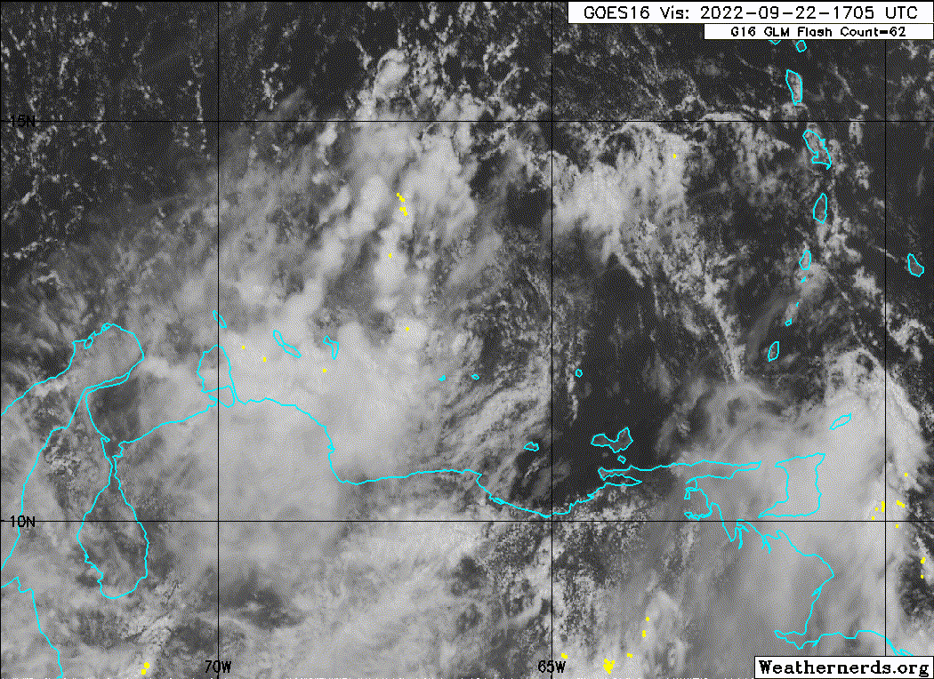
Cleary can see a vortex on visible. Time will tell if this is something spinning around a larger circulation or not. 12.8n and 66.8w ish?
0 likes
The following post is NOT an official forecast and should not be used as such. It is just the opinion of the poster and may or may not be backed by sound meteorological data. It is NOT endorsed by any professional institution including storm2k.org For Official Information please refer to the NHC and NWS products. http://www.nhc.noaa.gov


Re: ATL: INVEST 98L - Discussion
ConvergenceZone wrote:ExBailbonds wrote:Well crap here we go after watching and following the 98L threads for a few days a will start finalizing prep in Homestead Fl. Been down this road a few times and i will be ready but i am hoping that i will not need any of it and it misses to the east somehow. I know not likely but holding out hope for my fellow Floridians.
Don't lose hope! It's still very possible that it could move completely east of Florida. Remember, unless it changes, the trend is your friend!
but yes, you definitely want to prepare, absolutely!! ........
Personally I do not think this will hit anywhere in the CONUS as of right now. The models keep tracking further and further east. Would not be shocked if by this time tomorrow Cuba and Jamaica and the Bahamas get this and the US os spared. Wouldn’t put my life on it but have seen this happen before.
0 likes
-
Hurricaneman

- Category 5
- Posts: 7282
- Age: 43
- Joined: Tue Aug 31, 2004 3:24 pm
- Location: central florida
Re: ATL: INVEST 98L - Discussion
stormhunter7 wrote:Cleary can see a vortex on visible. Time will tell if this is something spinning around a larger circulation or not. 12.8n and 66.8w ish?
It’s an eddy rotating around a broad center
0 likes
-
Sciencerocks
- Category 5
- Posts: 7286
- Age: 38
- Joined: Thu Jul 06, 2017 1:51 am
-
Hurricaneman
- Category 5
- Posts: 7282
- Age: 43
- Joined: Tue Aug 31, 2004 3:24 pm
- Location: central florida
-
MGC

- S2K Supporter

- Posts: 5792
- Joined: Sun Mar 23, 2003 9:05 pm
- Location: Pass Christian MS, or what is left.
Re: ATL: INVEST 98L - Discussion
Hurricaneman wrote:stormhunter7 wrote:Cleary can see a vortex on visible. Time will tell if this is something spinning around a larger circulation or not. 12.8n and 66.8w ish?
It’s an eddy rotating around a broad center[/quote
yup, its moving north.....MGC
0 likes
-
Aric Dunn
- Category 5
- Posts: 21228
- Age: 41
- Joined: Sun Sep 19, 2004 9:58 pm
- Location: Ready for the Chase.
- Contact:
Re: ATL: INVEST 98L - Discussion
MGC wrote:Hurricaneman wrote:stormhunter7 wrote:Cleary can see a vortex on visible. Time will tell if this is something spinning around a larger circulation or not. 12.8n and 66.8w ish?
It’s an eddy rotating around a broad center[/quote
yup, its moving north.....MGC
in the middle of that eddy and the one forming to the west of it with some convection popping. the one diving SW has a bunch more energy and should pop off another round of convection.
0 likes
Note: If I make a post that is brief. Please refer back to previous posts for the analysis or reasoning. I do not re-write/qoute what my initial post said each time.
If there is nothing before... then just ask
Space & Atmospheric Physicist, Embry-Riddle Aeronautical University,
I believe the sky is falling...
If there is nothing before... then just ask
Space & Atmospheric Physicist, Embry-Riddle Aeronautical University,
I believe the sky is falling...

Re: ATL: INVEST 98L - Discussion
Hurricaneman wrote:My opinion is the center of the broad low is 67.1w 12.2n
The shear is really doing a number on this system but the convection has been streaming off the surface near there. The naked dry eddy racing off to the northeast near 12.8N may not have any pressure profile with it.
It was supposed to stay sheared for a couple days and the models are going to be wrong until they get a better initialization south of Jamaica.
1 likes
-
ConvergenceZone
- Category 5
- Posts: 4833
- Joined: Fri Jul 29, 2005 1:40 am
- Location: Northern California
Re: ATL: INVEST 98L - Discussion
WiscoWx02 wrote:ConvergenceZone wrote:ExBailbonds wrote:Well crap here we go after watching and following the 98L threads for a few days a will start finalizing prep in Homestead Fl. Been down this road a few times and i will be ready but i am hoping that i will not need any of it and it misses to
the east somehow. I know not likely but holding out hope for my fellow Floridians.
Don't lose hope! It's still very possible that it could move completely east of Florida. Remember, unless it changes, the trend is your friend!
but yes, you definitely want to prepare, absolutely!! ........
Personally I do not think this will hit anywhere in the CONUS as of right now. The models keep tracking further and further east. Would not be shocked if by this time tomorrow Cuba and Jamaica and the Bahamas get this and the US os spared. Wouldn’t put my life on it but have seen this happen before.
Yea a good friend of mine who I went to college with who is now a pro meteorologist, who tracks the tropics in his spare time said the same thing. He thinks there is a very good chance this misses the USA Mainland all-together. I'm kinda in the middle. I think it's going to be a really close call, but I think that the southern tip of Florida will end up getting clipped..........
Last edited by ConvergenceZone on Thu Sep 22, 2022 4:05 pm, edited 1 time in total.
0 likes

Re: ATL: INVEST 98L - Discussion
I lurk a lot and post a little, but know enough to heed mr. wxman. Finally repaired my Irma-damaged main lanai panel this summer so we're pretty much ready to go. We've got supplies, etc. and will get full tanks tonight before the crazies get out there tomorrow. Would only consider leaving if forecast track parallels close offshore or comes in north of Fort Myers. We live on the water and are prone to surge. Irma surge forecasts for our neighbor hood were 6-9 ft above ground level which fortunately did not happen. Back to lurking ...
2 likes
Elena '85 - Charley '04 - Wilma '05 - Irma '17 - Ian '22 - Idalia '23
-
Poonwalker
- Tropical Storm
- Posts: 146
- Joined: Tue Sep 20, 2022 11:12 am
Re: ATL: INVEST 98L - Discussion
looks like a case where proximity to land tightened it up. I feel like my fears are playing out on this one, coming into the gulf from that angle is not a good thing for central florida, almost has to be the perfect setup honestly. I looked at the climatology maps and the end of September and early October favor this exact setup where a similar trough presentation brought them in.
5 likes
Re: ATL: INVEST 98L - Discussion
Really hope the people who organized the work conference I'm going to in Miami next week are paying attention. Fly down Monday and have anxiety about it already.
1 likes
-
Aric Dunn
- Category 5
- Posts: 21228
- Age: 41
- Joined: Sun Sep 19, 2004 9:58 pm
- Location: Ready for the Chase.
- Contact:
Re: ATL: INVEST 98L - Discussion
New meso vort that is dropping SW and starting to fire some towers is about to eat the other vort moving nnw... will probably take over for now. maybe get it just far enough west get into slightly lower shear for the night.
5 likes
Note: If I make a post that is brief. Please refer back to previous posts for the analysis or reasoning. I do not re-write/qoute what my initial post said each time.
If there is nothing before... then just ask
Space & Atmospheric Physicist, Embry-Riddle Aeronautical University,
I believe the sky is falling...
If there is nothing before... then just ask
Space & Atmospheric Physicist, Embry-Riddle Aeronautical University,
I believe the sky is falling...
-
typhoonty
- Tropical Depression

- Posts: 94
- Age: 29
- Joined: Wed May 31, 2017 10:37 pm
- Location: Fort Myers / Tallahassee, FL
- Contact:
Re: ATL: INVEST 98L - Discussion
WiscoWx02 wrote:ConvergenceZone wrote:ExBailbonds wrote:Well crap here we go after watching and following the 98L threads for a few days a will start finalizing prep in Homestead Fl. Been down this road a few times and i will be ready but i am hoping that i will not need any of it and it misses to the east somehow. I know not likely but holding out hope for my fellow Floridians.
Don't lose hope! It's still very possible that it could move completely east of Florida. Remember, unless it changes, the trend is your friend!
but yes, you definitely want to prepare, absolutely!! ........
Personally I do not think this will hit anywhere in the CONUS as of right now. The models keep tracking further and further east. Would not be shocked if by this time tomorrow Cuba and Jamaica and the Bahamas get this and the US os spared. Wouldn’t put my life on it but have seen this happen before.
This is the wrong answer. The models have shifted east for a grand total of two cycles after 8 or so consecutive cycles of westerly movement of the consensus previous to that. I agree that we should root for a quick right turn through the FL Strait marine zones, but that is not the forecast right now. I have been telling people to prepare now by doing things like getting gas and non-perishable groceries. Things you may need for this event, but that you won't hate yourself for doing in case this doesn't end up being "the one."
10 likes
FSU Meteorology student, opinions are mine, 18 years experience covering TC's, consult NHC/Local officials when making decisions.
Gabrielle '01, Michelle '01, Charley '04, Frances '04, Dennis '05, Katrina '05, Rita '05, Wilma '05, Fay '08, Isaac '12 Hermine '16, Irma '17, Gordon '18, Michael '18, Eta '20 IAN '22
Gabrielle '01, Michelle '01, Charley '04, Frances '04, Dennis '05, Katrina '05, Rita '05, Wilma '05, Fay '08, Isaac '12 Hermine '16, Irma '17, Gordon '18, Michael '18, Eta '20 IAN '22
-
toad strangler

- S2K Supporter
- Posts: 4162
- Joined: Sun Jul 28, 2013 3:09 pm
- Location: Earth
- Contact:
Re: ATL: INVEST 98L - Discussion
typhoonty wrote:WiscoWx02 wrote:ConvergenceZone wrote:
Don't lose hope! It's still very possible that it could move completely east of Florida. Remember, unless it changes, the trend is your friend!
but yes, you definitely want to prepare, absolutely!! ........
Personally I do not think this will hit anywhere in the CONUS as of right now. The models keep tracking further and further east. Would not be shocked if by this time tomorrow Cuba and Jamaica and the Bahamas get this and the US os spared. Wouldn’t put my life on it but have seen this happen before.
This is the wrong answer. The models have shifted east for a grand total of two cycles after 8 or so consecutive cycles of westerly movement of the consensus previous to that. I agree that we should root for a quick right turn through the FL Strait marine zones, but that is not the forecast right now. I have been telling people to prepare now by doing things like getting gas and non-perishable groceries. Things you may need for this event, but that you won't hate yourself for doing in case this doesn't end up being "the one."
Sound advice
5 likes
Who is online
Users browsing this forum: No registered users and 63 guests