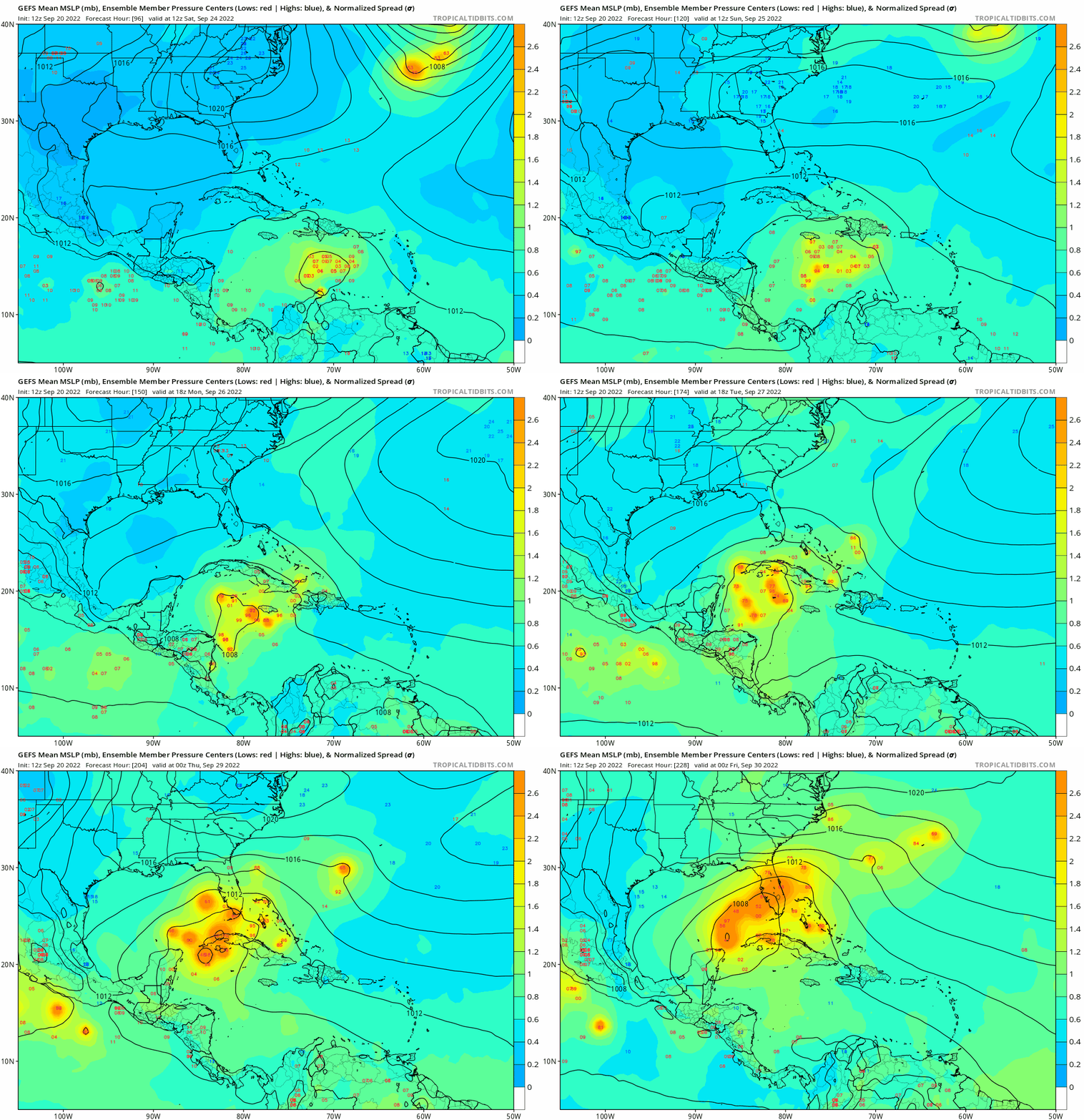
ATL: IAN - Models
Moderator: S2k Moderators
- toad strangler
- S2K Supporter

- Posts: 4162
- Joined: Sun Jul 28, 2013 3:09 pm
- Location: Earth
- Contact:
Re: ATL: INVEST 98L - Models
InfernoFlameCat wrote:Slams into the Florida Panhandle. In the same spot as Michael did.
No, Michael hit the left side of the panhandle, while this storm hit the right side.
0 likes
- skyline385
- Category 5

- Posts: 2444
- Age: 33
- Joined: Wed Aug 26, 2020 11:15 pm
- Location: Palm Beach County FL
ATL: INVEST 98L - Models
tomatkins wrote:skyline385 wrote:Also in case anyone missed it, 98L already has an elongated circulation so it could possibly develop ahead of schedule
Sent from my iPhone using Tapatalk
Are we seeing the familiar stronger = earlier turn north dynamic. Because if so, early strengthening could be a saving grace for the western Caribbean and possibly the US as well.
I don’t think that would matter much until the ridge weakens. A stronger system would then make a faster turn but it would still be near Cuba already.
Sent from my iPhone using Tapatalk
1 likes
Re: ATL: INVEST 98L - Models
Ten days out got plenty of time to watch if our forecast holds no problem and it should temps 64' 9/28/22 but Fl/GA??
1 likes
-
Stormcenter
- S2K Supporter

- Posts: 6617
- Joined: Wed Sep 03, 2003 11:27 am
- Location: Houston, TX
- Iceresistance
- Category 5

- Posts: 8913
- Age: 20
- Joined: Sat Oct 10, 2020 9:45 am
- Location: Tecumseh, OK/Norman, OK
Re: ATL: INVEST 98L - Models
0 likes
Bill 2015 & Beta 2020
Winter 2020-2021
All observations are in Tecumseh, OK unless otherwise noted.
Winter posts are focused mainly for Oklahoma & Texas.
Take any of my forecasts with a grain of salt, refer to the NWS, SPC, and NHC for official information
Never say Never with weather! Because ANYTHING is possible!
Winter 2020-2021

All observations are in Tecumseh, OK unless otherwise noted.
Winter posts are focused mainly for Oklahoma & Texas.
Take any of my forecasts with a grain of salt, refer to the NWS, SPC, and NHC for official information
Never say Never with weather! Because ANYTHING is possible!
Re: ATL: INVEST 98L - Models
12z gfs a little left of the 6z. (Tidbits is overloaded with traffic now it seems)


Last edited by BobHarlem on Tue Sep 20, 2022 11:55 am, edited 1 time in total.
1 likes
Re: ATL: INVEST 98L - Models
12z CMC almost identical to 12z GFS on strength and timing. Into Florida big bend in 940s mb range.
0 likes
- HurricaneBelle
- S2K Supporter

- Posts: 974
- Joined: Sun Aug 27, 2006 6:12 pm
- Location: Clearwater, FL
- crownweather
- S2K Supporter

- Posts: 576
- Age: 49
- Joined: Sat Aug 12, 2006 9:21 am
- Location: Sturbridge, Massachusetts
- Contact:
Re: ATL: INVEST 98L - Models
ronjon wrote:12z CMC almost identical to 12z GFS on strength and timing. Into Florida big bend in 940s mb range.
It actually looked like the 12Z CMC buried 98L into the Bay of Campeche by 240 hrs. Looks to far west to me.
1 likes
Rob Lightbown
Crown Weather Services
https://crownweather.com
Crown Weather Services
https://crownweather.com
Re: ATL: INVEST 98L - Models
A couple of things to note:
A storm of that size and strength is going to have titanic waves bouncing all around the Gulf. Right hand side, Tampa, et al, are going to see a materially damaging storm surge.
Second, this track absolutely has Tallahassee with full-blown at least SS-2 hurricane conditions, like Michael, Georgia will have a strong inland hurricane.
Third, this is going to absolutely whack the East Coast with rain and tornados.
This is, all, in all, a pretty bad run even if not charismatically disastrous like a Tampa Bay landfall.
7 likes
- tarheelprogrammer
- S2K Supporter

- Posts: 1793
- Joined: Mon Mar 28, 2016 9:25 pm
- Location: Raleigh, NC area (Garner, NC)
Re: ATL: INVEST 98L - Models
I think the models will flip to an East Coast threat in a few days. Ensembles show this as a possibility.
4 likes
My posts are not official forecasts. They are just my opinion and may or may not be backed by sound meteorological data. They are NOT endorsed by any professional institution or storm2k.org. For official information, please refer to the NHC and NWS products.
Re: ATL: INVEST 98L - Models
ronjon wrote:12z CMC almost identical to 12z GFS on strength and timing. Into Florida big bend in 940s mb range.
Are you sure about that, the CMC that I looking at has it in the bay of Campeche
0 likes
-
AutoPenalti
- Category 5

- Posts: 3949
- Age: 27
- Joined: Mon Aug 17, 2015 4:16 pm
- Location: Ft. Lauderdale, Florida
Re: ATL: INVEST 98L - Models
ronjon wrote:12z CMC almost identical to 12z GFS on strength and timing. Into Florida big bend in 940s mb range.
Not sure what run that is.
0 likes
The posts in this forum are NOT official forecasts and should not be used as such. They are just the opinion of the poster and may or may not be backed by sound meteorological data. They are NOT endorsed by any professional institution or STORM2K. For official information, please refer to products from the NHC and NWS.
Model Runs Cheat Sheet:
GFS (5:30 AM/PM, 11:30 AM/PM)
HWRF, GFDL, UKMET, NAVGEM (6:30-8:00 AM/PM, 12:30-2:00 AM/PM)
ECMWF (1:45 AM/PM)
TCVN is a weighted averaged
Re: ATL: INVEST 98L - Models
ronjon wrote:12z CMC almost identical to 12z GFS on strength and timing. Into Florida big bend in 940s mb range.
Double check that, the Canadian seems to head into the bay of campeche (again) very close to where the 0z had it. 12z Icon starts to bend north toward the Yucatan Channel in the Western Caribbean this time (0z was moving more toward the Yucatan Peninsula)

Last edited by BobHarlem on Tue Sep 20, 2022 12:12 pm, edited 1 time in total.
0 likes
-
AutoPenalti
- Category 5

- Posts: 3949
- Age: 27
- Joined: Mon Aug 17, 2015 4:16 pm
- Location: Ft. Lauderdale, Florida
Re: ATL: INVEST 98L - Models
HWRF has some land interaction that slightly weakens it.
1 likes
The posts in this forum are NOT official forecasts and should not be used as such. They are just the opinion of the poster and may or may not be backed by sound meteorological data. They are NOT endorsed by any professional institution or STORM2K. For official information, please refer to products from the NHC and NWS.
Model Runs Cheat Sheet:
GFS (5:30 AM/PM, 11:30 AM/PM)
HWRF, GFDL, UKMET, NAVGEM (6:30-8:00 AM/PM, 12:30-2:00 AM/PM)
ECMWF (1:45 AM/PM)
TCVN is a weighted averaged
- Spacecoast
- Category 2

- Posts: 687
- Joined: Thu Aug 31, 2017 2:03 pm
-
jlauderdal
- S2K Supporter

- Posts: 6771
- Joined: Wed May 19, 2004 5:46 am
- Location: NE Fort Lauderdale
- Contact:
Re: ATL: INVEST 98L - Models
Spacecoast wrote:12z GEFS shifts west from 6z
trend:
https://i.ibb.co/hVrQ1kQ/gfs-ememb-lowlocs-watl-fh216-trend.gif
Not good at all, we were looking for a continuing eastward trend, for now, its an eastern gulf, north gulf coast hit with the whole peninsula felling it in one form or another on the dirty side. One run of course but the back and forth in a range is not what we want to see. Euro up next.
0 likes
- SFLcane
- S2K Supporter

- Posts: 9606
- Age: 46
- Joined: Sat Jun 05, 2010 1:44 pm
- Location: Lake Worth Florida
Re: ATL: INVEST 98L - Models
Spacecoast wrote:12z GEFS shifts west from 6z
trend:
https://i.ibb.co/hVrQ1kQ/gfs-ememb-lowlocs-watl-fh216-trend.gif
Not much of a shift still good chunk hook NE into Florida.

1 likes
Who is online
Users browsing this forum: No registered users and 68 guests


