WPAC: NORU - Post-Tropical

Moderator: S2k Moderators

Message
Author
User avatar
cycloneye
Admin
Admin
Posts: 139027
Age: 67
Joined: Thu Oct 10, 2002 10:54 am
Location: San Juan, Puerto Rico

Re: WPAC: NORU - Typhoon

#181 Postby cycloneye » Mon Sep 26, 2022 2:53 pm

mrbagyo wrote:That's a very intense typhoon with a distinct pinhole eye.
Ive never seen a typhoon have a pinhole eye like this in the South China Sea after crossing the Philippines.

There's a developing concentric eyewall by the way.
https://s4.gifyu.com/images/ezgif-2-8a64040267.gif


That is a impressive radar presentation.
0 likes   
Visit the Caribbean-Central America Weather Thread where you can find at first post web cams,radars
and observations from Caribbean basin members Click Here

User avatar
mrbagyo
Category 5
Category 5
Posts: 3614
Age: 31
Joined: Thu Apr 12, 2012 9:18 am
Location: 14.13N 120.98E
Contact:

Re: WPAC: NORU - Typhoon

#182 Postby mrbagyo » Mon Sep 26, 2022 3:08 pm

18W NORU 220926 1800 15.9N 113.9E WPAC 90 956

90 knots appears way too low now, Noru might be back at STY strength with that distinct pinhole eye. Could be making a run at Cat 5 again if not already.
0 likes   
The posts in this forum are NOT official forecast and should not be used as such. They are just the opinion of the poster and may or may not be backed by sound meteorological data. They are NOT endorsed by any professional institution or storm2k.org. For official information, please refer to RSMC, NHC and NWS products.

User avatar
Iceresistance
Category 5
Category 5
Posts: 8911
Age: 20
Joined: Sat Oct 10, 2020 9:45 am
Location: Tecumseh, OK/Norman, OK

Re: WPAC: NORU - Typhoon

#183 Postby Iceresistance » Mon Sep 26, 2022 4:15 pm

1 likes   
Bill 2015 & Beta 2020

Winter 2020-2021 :cold:

All observations are in Tecumseh, OK unless otherwise noted.

Winter posts are focused mainly for Oklahoma & Texas.

Take any of my forecasts with a grain of salt, refer to the NWS, SPC, and NHC for official information

Never say Never with weather! Because ANYTHING is possible!

User avatar
Highteeld
Category 5
Category 5
Posts: 2097
Age: 40
Joined: Tue Jan 30, 2018 9:10 pm
Location: Chicago

Re: WPAC: NORU - Typhoon

#184 Postby Highteeld » Mon Sep 26, 2022 4:18 pm

Those feeder bands are very intense. Haiyan-esque

Image
4 likes   
Very useful information on the Dvorak Technique --

https://severe.worldweather.wmo.int/TCF ... kBeven.pdf

StormTracker89
Tropical Depression
Tropical Depression
Posts: 57
Joined: Sat May 16, 2020 3:47 pm
Location: Somewhere in the Pacific

Re: WPAC: NORU - Typhoon

#185 Postby StormTracker89 » Mon Sep 26, 2022 4:38 pm

NORU doing it's best RAI interpretation, making a run for super a second time around in the SCS.
2 likes   

User avatar
doomhaMwx
Category 5
Category 5
Posts: 2398
Age: 25
Joined: Tue Apr 18, 2017 4:01 am
Location: Baguio/Benguet, Philippines
Contact:

Re: WPAC: NORU - Typhoon

#186 Postby doomhaMwx » Mon Sep 26, 2022 5:31 pm

That pinhole eye might have to go away soon as radar shows hints of an outer eyewall forming.

Image
0 likes   
Like my content? Consider giving a tip.

User avatar
doomhaMwx
Category 5
Category 5
Posts: 2398
Age: 25
Joined: Tue Apr 18, 2017 4:01 am
Location: Baguio/Benguet, Philippines
Contact:

Re: WPAC: NORU - Typhoon

#187 Postby doomhaMwx » Mon Sep 26, 2022 5:52 pm

For a system in the South China Sea, the CMA seems to be closer to reality again.
JTWC 18Z: 90kt/956mb (1-min)
JMA 21Z: 80kt/960mb (10-min)
CMA 21Z: 105kt/930mb (2-min)

Image
0 likes   
Like my content? Consider giving a tip.

User avatar
Highteeld
Category 5
Category 5
Posts: 2097
Age: 40
Joined: Tue Jan 30, 2018 9:10 pm
Location: Chicago

Re: WPAC: NORU - Typhoon

#188 Postby Highteeld » Mon Sep 26, 2022 5:53 pm

CMA is an underrated agency.
3 likes   
Very useful information on the Dvorak Technique --

https://severe.worldweather.wmo.int/TCF ... kBeven.pdf

User avatar
cycloneye
Admin
Admin
Posts: 139027
Age: 67
Joined: Thu Oct 10, 2002 10:54 am
Location: San Juan, Puerto Rico

Re: WPAC: NORU - Typhoon

#189 Postby cycloneye » Mon Sep 26, 2022 6:38 pm

0 likes   
Visit the Caribbean-Central America Weather Thread where you can find at first post web cams,radars
and observations from Caribbean basin members Click Here

MarioProtVI
Category 2
Category 2
Posts: 669
Age: 22
Joined: Sun Sep 29, 2019 7:33 pm
Location: New Jersey

Re: WPAC: NORU - Typhoon

#190 Postby MarioProtVI » Mon Sep 26, 2022 6:39 pm

Man, Noru trying to run at C5 again while inbound to one of the densely populated areas of Vietnam while Ian targets a city that hasn’t seen a major for a century. Mother Nature really hating us right now.
2 likes   

User avatar
doomhaMwx
Category 5
Category 5
Posts: 2398
Age: 25
Joined: Tue Apr 18, 2017 4:01 am
Location: Baguio/Benguet, Philippines
Contact:

Re: WPAC: NORU - Typhoon

#191 Postby doomhaMwx » Mon Sep 26, 2022 6:47 pm

FY-4A VIS
Passing just south of the Paracel Islands (Xisha / Hoang Sa).

Image
Image
5 likes   
Like my content? Consider giving a tip.

Ntxw
Storm2k Moderator
Storm2k Moderator
Posts: 21495
Joined: Wed Oct 21, 2009 6:34 pm
Location: DFW, Texas

Re: WPAC: NORU - Typhoon

#192 Postby Ntxw » Mon Sep 26, 2022 6:48 pm

Noru is an absolute beast again. Scary for the central coast of Vietnam.
0 likes   
The above post and any post by Ntxw is NOT an official forecast and should not be used as such. It is just the opinion of the poster and may or may not be backed by sound meteorological data. It is NOT endorsed by any professional institution including Storm2k. For official information, please refer to NWS products.

  Help support Storm2K!
Help Support Storm2K

User avatar
Hurricane2022
Category 4
Category 4
Posts: 911
Joined: Tue Aug 23, 2022 11:38 pm
Location: Araçatuba, Brazil

Re: WPAC: NORU - Typhoon

#193 Postby Hurricane2022 » Mon Sep 26, 2022 7:09 pm

JTWC being JTWC
I think they will revise it later
18W NORU 220927 0000 15.5N 112.2E WPAC 90 956
0 likes   
Sorry for the bad English sometimes...!
For reliable and detailed information for any meteorological phenomenon, please consult the National Hurricane Center, Joint Typhoon Warning Center , or your local Meteo Center.

--------

Una cvm Christo, pro Christo, et in Christo. Sit nomen Domini benedictvm.

User avatar
ElectricStorm
Category 5
Category 5
Posts: 4524
Age: 23
Joined: Tue Aug 13, 2019 11:23 pm
Location: Skiatook, OK / Norman, OK

Re: WPAC: NORU - Typhoon

#194 Postby ElectricStorm » Mon Sep 26, 2022 7:32 pm

18W NORU 220927 0000 15.5N 112.2E WPAC 125 944
2 likes   
I am in no way a professional. Take what I say with a grain of salt as I could be totally wrong. Please refer to the NHC, NWS, or SPC for official information.

Boomer Sooner!

User avatar
doomhaMwx
Category 5
Category 5
Posts: 2398
Age: 25
Joined: Tue Apr 18, 2017 4:01 am
Location: Baguio/Benguet, Philippines
Contact:

Re: WPAC: NORU - Typhoon

#195 Postby doomhaMwx » Mon Sep 26, 2022 7:36 pm

Another massive Intensity increase from JTWC at 00Z, and the 90kts for 18Z was revised to 100kts. This is already the second time we've seen something like this in Noru's lifetime.
18W NORU 220927 0000 15.5N 112.2E WPAC 125 944
18W NORU 220926 1800 15.7N 114.0E WPAC 100 958
3 likes   
Like my content? Consider giving a tip.

User avatar
Hurricane2022
Category 4
Category 4
Posts: 911
Joined: Tue Aug 23, 2022 11:38 pm
Location: Araçatuba, Brazil

Re: WPAC: NORU - Typhoon

#196 Postby Hurricane2022 » Mon Sep 26, 2022 7:42 pm

ElectricStorm wrote:
18W NORU 220927 0000 15.5N 112.2E WPAC 125 944

Thank God
0 likes   
Sorry for the bad English sometimes...!
For reliable and detailed information for any meteorological phenomenon, please consult the National Hurricane Center, Joint Typhoon Warning Center , or your local Meteo Center.

--------

Una cvm Christo, pro Christo, et in Christo. Sit nomen Domini benedictvm.

User avatar
mrbagyo
Category 5
Category 5
Posts: 3614
Age: 31
Joined: Thu Apr 12, 2012 9:18 am
Location: 14.13N 120.98E
Contact:

Re: WPAC: NORU - Typhoon

#197 Postby mrbagyo » Mon Sep 26, 2022 8:16 pm

What's CMA's current intensity for 00z ?
0 likes   
The posts in this forum are NOT official forecast and should not be used as such. They are just the opinion of the poster and may or may not be backed by sound meteorological data. They are NOT endorsed by any professional institution or storm2k.org. For official information, please refer to RSMC, NHC and NWS products.

User avatar
Ed_2001
Tropical Storm
Tropical Storm
Posts: 228
Age: 22
Joined: Wed Jun 21, 2017 11:39 pm
Location: Santa Barbara, CA>>Tampa, FL

Re: WPAC: NORU - Typhoon

#198 Postby Ed_2001 » Mon Sep 26, 2022 8:16 pm

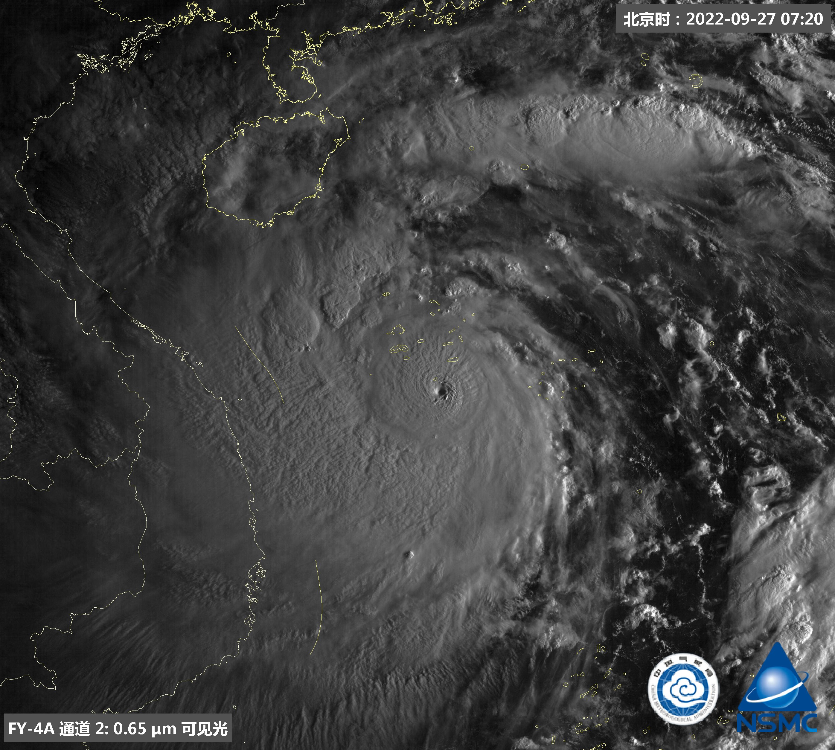
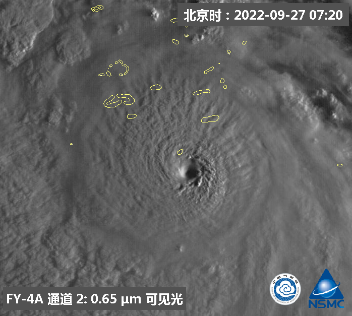
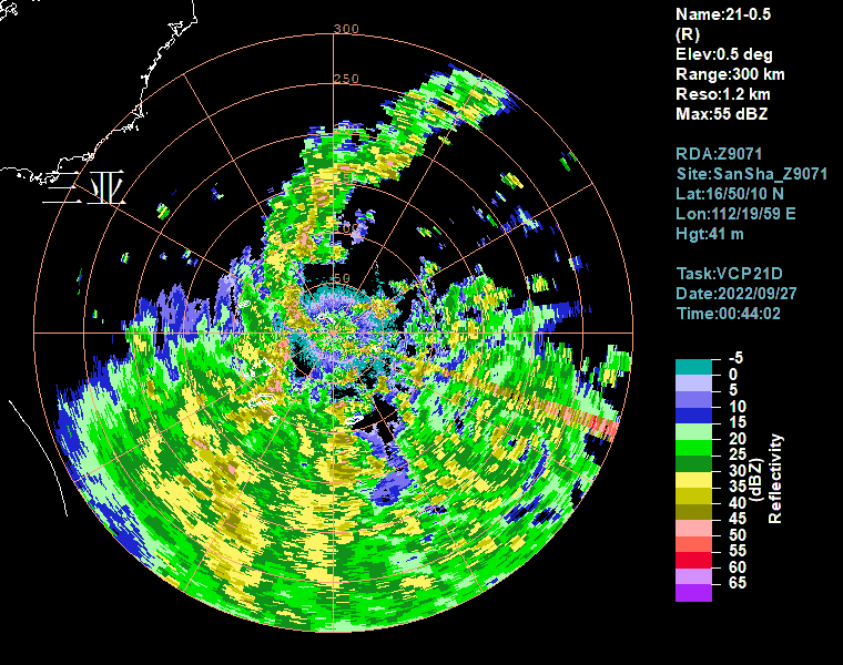
As with Noru’s first peak shear is impacting the system making the CDO less symmetrical compared to 2-3 hours ago, and the eye is cooling as well after making a run toward ow earlier. Still a very impressive system for scs and I honestly wouldn’t be shocked if it peaked at C5 briefly earlier. Without shear, it almost looked as if Noru was trying to make a run for 155kts+

And once again, won’t change the fact that Noru will unfortunately soon make a devastating hit, likely as the strongest storm Vietnam have ever seen since reliable wpac record keeping began as iirc their strongest recorded typhoon was “only” 105kts
Image
2 likes   
The answer my friend, is blowing in the wind...

User avatar
Hayabusa
Category 5
Category 5
Posts: 3737
Joined: Sun Sep 16, 2018 1:05 pm

Re: WPAC: NORU - Typhoon

#199 Postby Hayabusa » Mon Sep 26, 2022 8:19 pm

WTPQ51 ‎RJTD ‎270000
RSMC ‎TROPICAL ‎CYCLONE ‎ADVISORY
NAME ‎ ‎TY ‎2216 ‎NORU ‎(2216)
ANALYSIS
PSTN ‎ ‎270000UTC ‎15.5N ‎112.1E ‎GOOD
MOVE ‎ ‎W ‎15KT
PRES ‎ ‎950HPA
MXWD ‎ ‎085KT
GUST ‎ ‎120KT
50KT ‎ ‎70NM
30KT ‎ ‎210NM ‎WEST ‎150NM ‎EAST
FORECAST
12HF ‎ ‎271200UTC ‎15.8N ‎110.3E ‎25NM ‎70%
MOVE ‎ ‎W ‎10KT
PRES ‎ ‎940HPA
MXWD ‎ ‎090KT
GUST ‎ ‎130KT
24HF ‎ ‎280000UTC ‎15.8N ‎108.2E ‎35NM ‎70%
MOVE ‎ ‎W ‎10KT
PRES ‎ ‎965HPA
MXWD ‎ ‎075KT
GUST ‎ ‎105KT
48HF ‎ ‎290000UTC ‎16.3N ‎104.2E ‎60NM ‎70% ‎TROPICAL ‎DEPRESSION ‎=
0 likes   
ヤンデレ女が寝取られるているのを見たい!!!
ECMWF ensemble NWPAC plots: https://ecmwfensnwpac.imgbb.com/
Multimodel NWPAC plots: https://multimodelnwpac.imgbb.com/
GFS Ensemble NWPAC plots (16 & 35 day forecast): https://gefsnwpac.imgbb.com/
Plots updated automatically

User avatar
Ed_2001
Tropical Storm
Tropical Storm
Posts: 228
Age: 22
Joined: Wed Jun 21, 2017 11:39 pm
Location: Santa Barbara, CA>>Tampa, FL

Re: WPAC: NORU - Typhoon

#200 Postby Ed_2001 » Mon Sep 26, 2022 8:23 pm

Interestingly, even though gfs and euro have foreseen a gradual weakening up to landfall, hwrf is showing intensification all the way until the end. I guess we will see soon enough…
0 likes   
The answer my friend, is blowing in the wind...


Return to “2022”

Who is online

Users browsing this forum: No registered users and 42 guests