https://twitter.com/ReedTimmerAccu/status/1578021975439855618
EPAC: JULIA - Remnants - Discussion
Moderator: S2k Moderators
-
cycloneye

- Admin

- Posts: 139092
- Age: 67
- Joined: Thu Oct 10, 2002 10:54 am
- Location: San Juan, Puerto Rico
Re: ATL: INVEST 91L - Discussion
0 likes
Visit the Caribbean-Central America Weather Thread where you can find at first post web cams,radars
and observations from Caribbean basin members Click Here
and observations from Caribbean basin members Click Here

Re: ATL: THIRTEEN - Potential Tropical Cyclone - Discussion
Special Message from NHC Issued 6 Oct 2022 14:19 UTC
NHC will initiate advisories on Potential Tropical Cyclone Thirteen, located over the south-central Caribbean Sea, at 1100 AM AST (1500 UTC).
NHC will initiate advisories on Potential Tropical Cyclone Thirteen, located over the south-central Caribbean Sea, at 1100 AM AST (1500 UTC).
4 likes

Re: ATL: INVEST 91L - Discussion
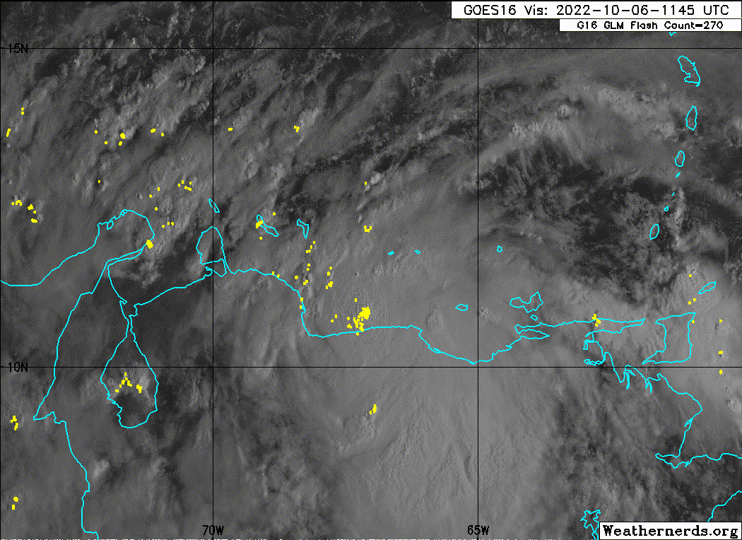
Just using visible/IR imagery, the MLC looks to be pretty far south at around 10.0-10.5N, well over land. I don't know why or how 91L seems to be trying to consolidate all the way down there.


0 likes
Irene '11 Sandy '12 Hermine '16 5/15/2018 Derecho Fay '20 Isaias '20 Elsa '21 Henri '21 Ida '21
I am only a meteorology enthusiast who knows a decent amount about tropical cyclones. Look to the professional mets, the NHC, or your local weather office for the best information.
I am only a meteorology enthusiast who knows a decent amount about tropical cyclones. Look to the professional mets, the NHC, or your local weather office for the best information.
-
ElectricStorm

- Category 5

- Posts: 4561
- Age: 23
- Joined: Tue Aug 13, 2019 11:23 pm
- Location: Skiatook, OK / Norman, OK
Re: ATL: THIRTEEN - Potential Tropical Cyclone - Discussion
Welp here we go
0 likes
I am in no way a professional. Take what I say with a grain of salt as I could be totally wrong. Please refer to the NHC, NWS, or SPC for official information.
Boomer Sooner!
Boomer Sooner!

Re: ATL: INVEST 91L - Discussion
Subtrop wrote:NHC will initiate advisories on Potential Tropical Cyclone Thirteen, located over the south-central Caribbean Sea, at 1100 AM AST (1500 UTC).
And that folks is how we know this is going to take FOREVER to develop...jk but it honestly feels like systems classified as PTC take at least 2 days to get there lol if they ever do at all. This system honestly looks well embedded in SA though, and almost looks like it's tracking further inland. Starting to wonder if anything even happens with this or if it is even able to get into the Caribbean Sea or if it tracks so far south it even misses the SW Caribbean Sea to the south.
0 likes
Re: ATL: INVEST 91L - Discussion
WiscoWx02 wrote:Subtrop wrote:NHC will initiate advisories on Potential Tropical Cyclone Thirteen, located over the south-central Caribbean Sea, at 1100 AM AST (1500 UTC).
And that folks is how we know this is going to take FOREVER to develop...jk but it honestly feels like systems classified as PTC take at least 2 days to get there lol if they ever do at all. This system honestly looks well embedded in SA though, and almost looks like it's tracking further inland. Starting to wonder if anything even happens with this or if it is even able to get into the Caribbean Sea or if it tracks so far south it even misses the SW Caribbean Sea to the south.
The 6Z GFS and the 0Z CMC have the very weak center over land later today and it still develops once back over water. The 6Z/0Z Euro both barely keep the not as weak center over water.
0 likes
Personal Forecast Disclaimer:
The posts in this forum are NOT official forecasts and should not be used as such. They are just the opinion of the poster and may or may not be backed by sound meteorological data. They are NOT endorsed by any professional institution or storm2k.org. For official information, please refer to the NHC and NWS products.
The posts in this forum are NOT official forecasts and should not be used as such. They are just the opinion of the poster and may or may not be backed by sound meteorological data. They are NOT endorsed by any professional institution or storm2k.org. For official information, please refer to the NHC and NWS products.
-
Iceresistance

- Category 5
- Posts: 8915
- Age: 20
- Joined: Sat Oct 10, 2020 9:45 am
- Location: Tecumseh, OK/Norman, OK
Re: ATL: THIRTEEN - Potential Tropical Cyclone - Discussion
Joe B thinks that this could be a major by the time it reaches Nicaragua. Very impressive convection being close to Venezuela.
0 likes
Bill 2015 & Beta 2020
Winter 2020-2021
All observations are in Tecumseh, OK unless otherwise noted.
Winter posts are focused mainly for Oklahoma & Texas.
Take any of my forecasts with a grain of salt, refer to the NWS, SPC, and NHC for official information
Never say Never with weather! Because ANYTHING is possible!
Winter 2020-2021
All observations are in Tecumseh, OK unless otherwise noted.
Winter posts are focused mainly for Oklahoma & Texas.
Take any of my forecasts with a grain of salt, refer to the NWS, SPC, and NHC for official information
Never say Never with weather! Because ANYTHING is possible!
-
MGC

- S2K Supporter

- Posts: 5792
- Joined: Sun Mar 23, 2003 9:05 pm
- Location: Pass Christian MS, or what is left.
Re: ATL: THIRTEEN - Potential Tropical Cyclone - Discussion
So far south is looks like it might hit Costa Rica......MGC
0 likes
-
MarioProtVI
- Category 2

- Posts: 670
- Age: 22
- Joined: Sun Sep 29, 2019 7:33 pm
- Location: New Jersey
Re: ATL: THIRTEEN - Potential Tropical Cyclone - Discussion
Iceresistance wrote:Joe B thinks that this could be a major by the time it reaches Nicaragua. Very impressive convection being close to Venezuela.
Highly doubt it and it may not even get to a hurricane or even named the further it stays this far south as it might just run straight into SA and dissipate.
0 likes
Re: ATL: THIRTEEN - Potential Tropical Cyclone - Discussion
MarioProtVI wrote:Iceresistance wrote:Joe B thinks that this could be a major by the time it reaches Nicaragua. Very impressive convection being close to Venezuela.
Highly doubt it and it may not even get to a hurricane or even named the further it stays this far south as it might just run straight into SA and dissipate.
As just mentioned, the GFS/CMC have it over land later today and it still becomes a TS+ by the weekend once back over water. The CMC has a TC tomorrow as do the UKMET/Euro. Now, regarding JB's MH prediction, we'll see. He loves to predict MHs.
0 likes
Personal Forecast Disclaimer:
The posts in this forum are NOT official forecasts and should not be used as such. They are just the opinion of the poster and may or may not be backed by sound meteorological data. They are NOT endorsed by any professional institution or storm2k.org. For official information, please refer to the NHC and NWS products.
The posts in this forum are NOT official forecasts and should not be used as such. They are just the opinion of the poster and may or may not be backed by sound meteorological data. They are NOT endorsed by any professional institution or storm2k.org. For official information, please refer to the NHC and NWS products.
-
weeniepatrol

- Category 3

- Posts: 857
- Joined: Sat Aug 22, 2020 5:30 pm
- Location: WA State
Re: ATL: THIRTEEN - Potential Tropical Cyclone - Discussion
Potential Tropical Cyclone Thirteen Discussion Number 1
NWS National Hurricane Center Miami FL AL132022
1100 AM AST Thu Oct 06 2022
A broad area of low pressure continues to move westward across the
far southeastern Caribbean Sea, with an expansive area of deep
convection stretching across northern South America and the
adjacent waters. The system does not appear to have a well-defined
center and therefore cannot yet be designated as a tropical
depression. However, the risk of tropical storm force winds has
increased for portions of the northern coast of South America, and
advisories are therefore being initiated on Potential Tropical
Cyclone Thirteen. The initial intensity is 30 kt based on ASCAT
data from last evening.
With the low remaining broad, the center is difficult to locate.
It's estimated to be over water just north of Venezuela based on
extrapolation, although it should be noted that stronger turning is
becoming evident in the cloud pattern a little farther south over
land. The track forecast reasoning is straightforward. Strong low-
to mid-level ridging over the western Atlantic and Gulf of Mexico is
expected to steer the disturbance westward along the northern coast
of South American and then across the southwestern Caribbean Sea
during the next 3 day or so, likely reaching the coast of Central
America sometime on Sunday. The track guidance is tightly clustered
during that period, with a little bit of speed differences, and the
official forecast track lies close to the TVCN and HCCA consensus
aids.
Land interaction will likely modulate the system's development over
the next 24 hours or so, both its designation as a tropical cyclone
and potential intensification. Intensity guidance is in fairly
good agreement that a well-defined center could form by tonight,
assuming the system is still over water, with winds potentially
increasing to tropical storm force by Friday morning. Once the
system clears land on Friday, low to moderate shear and warm waters
of 29 to 30 degrees Celsius should foster more significant
development, with the system forecast to become a hurricane before
it reaches the coast of Central America on Sunday. The NHC
intensity forecast is near a blend of the IVCN and HCCA consensus
aids, although it's important to note that some intensity models,
including HWRF and the ECMWF-based SHIPS, are as much as 15 kt
higher at 72 hours.
Key Messages:
1. Tropical storm conditions are expected across portions of the
Guajira Peninsula of Colombia tonight and early Friday, where a
Tropical Storm Warning has been issued. Gusts to tropical storm
force are possible across portions of northern Venezuela, Aruba,
Curacao, and Bonaire through early Friday.
2. The system is expected to strengthen when it moves over the
southwestern Caribbean Sea, and interests in San Andres,
Providencia, and portions of Central America should closely monitor
its progress. Watches could be required for portions of that area
later today or tonight.
3. Heavy rainfall could cause life-threatening flash flooding in
portions of the Guajira Peninsula of Colombia, northern Venezuela,
Aruba, Bonaire and Curacao during the next day or so. Heavy
rains, and the potential for flash flooding and mudslides, are
expected to spread to portions of Central America this weekend.
FORECAST POSITIONS AND MAX WINDS
INIT 06/1500Z 11.4N 67.0W 30 KT 35 MPH...POTENTIAL TROP CYCLONE
12H 07/0000Z 11.8N 69.0W 30 KT 35 MPH...TROPICAL DEPRESSION
24H 07/1200Z 12.3N 71.9W 35 KT 40 MPH...NEAR GUAJIRA PENINSULA
36H 08/0000Z 12.9N 74.9W 40 KT 45 MPH...OVER WATER
48H 08/1200Z 13.0N 78.0W 50 KT 60 MPH
60H 09/0000Z 12.9N 80.6W 60 KT 70 MPH
72H 09/1200Z 12.8N 82.7W 70 KT 80 MPH
96H 10/1200Z 13.8N 86.8W 45 KT 50 MPH...INLAND
120H 11/1200Z 15.6N 91.2W 25 KT 30 MPH...POST-TROP/REMNT LOW
$$
72H 09/1200Z 12.8N 82.7W 70 KT 80 MPH
0 likes
Re: ATL: THIRTEEN - Potential Tropical Cyclone - Discussion
LarryWx wrote:MarioProtVI wrote:Iceresistance wrote:Joe B thinks that this could be a major by the time it reaches Nicaragua. Very impressive convection being close to Venezuela.
Highly doubt it and it may not even get to a hurricane or even named the further it stays this far south as it might just run straight into SA and dissipate.
As just mentioned, the GFS/CMC have it over land later today and it still becomes a TS+ over the weekend once back over water. Now, regarding JB's MH prediction, we'll see. He loves to predict MHs.
It is possible that PTC13 becomes a major if the LLC forms north over water like all the models say it should. However, it’s really looking like it’s forming over Venezuela, which could cause it to dissipate altogether before even reaching the SWCar.
1 likes
Irene '11 Sandy '12 Hermine '16 5/15/2018 Derecho Fay '20 Isaias '20 Elsa '21 Henri '21 Ida '21
I am only a meteorology enthusiast who knows a decent amount about tropical cyclones. Look to the professional mets, the NHC, or your local weather office for the best information.
I am only a meteorology enthusiast who knows a decent amount about tropical cyclones. Look to the professional mets, the NHC, or your local weather office for the best information.
-
MarioProtVI
- Category 2
- Posts: 670
- Age: 22
- Joined: Sun Sep 29, 2019 7:33 pm
- Location: New Jersey
Re: ATL: THIRTEEN - Potential Tropical Cyclone - Discussion
LarryWx wrote:MarioProtVI wrote:Iceresistance wrote:Joe B thinks that this could be a major by the time it reaches Nicaragua. Very impressive convection being close to Venezuela.
Highly doubt it and it may not even get to a hurricane or even named the further it stays this far south as it might just run straight into SA and dissipate.
As just mentioned, the GFS/CMC have it over land later today and it still becomes a TS+ by the weekend once back over water. The CMC has a TC tomorrow as do the UKMET/Euro. Now, regarding JB's MH prediction, we'll see. He loves to predict MHs.
Visible satellite indicates the MLC is well inland with small hints of a very weak LLC just over water. Indicative of shear and prone to either dissipating or getting dragged in. If the MLC remains over land this has no shot at developing further, which apparently seems to be the trends with POTCs this year.
0 likes
-
Category5Kaiju

- Category 5
- Posts: 3360
- Age: 22
- Joined: Thu Dec 24, 2020 12:45 pm
- Location: Seattle
Re: ATL: INVEST 91L - Discussion
aspen wrote:Just using visible/IR imagery, the MLC looks to be pretty far south at around 10.0-10.5N, well over land. I don't know why or how 91L seems to be trying to consolidate all the way down there.
https://i.imgur.com/cdfabd4.jpg
https://i.imgur.com/aiBFJNI.jpg
Well you have to keep in mind that much of the geography there is swamp and rainforest rather than tall mountains or desert (at least based on Koppen climate classifications, it's a moist place), so it's not like going over land will be a death sentence for this system.
3 likes
Unless explicitly stated, all information covered in my posts is based on my opinions and observations. Please refer to a professional meteorologist or an accredited weather research agency otherwise, especially if serious decisions must be made in the event of a potentially life-threatening tropical storm or hurricane.
-
cycloneye
- Admin
- Posts: 139092
- Age: 67
- Joined: Thu Oct 10, 2002 10:54 am
- Location: San Juan, Puerto Rico
Re: ATL: THIRTEEN - Potential Tropical Cyclone - Discussion
Key part of discussion.
Once the
system clears land on Friday, low to moderate shear and warm waters
of 29 to 30 degrees Celsius should foster more significant
development, with the system forecast to become a hurricane before
it reaches the coast of Central America on Sunday. The NHC
intensity forecast is near a blend of the IVCN and HCCA consensus
aids, although it's important to note that some intensity models,
including HWRF and the ECMWF-based SHIPS, are as much as 15 kt
higher at 72 hours.
2 likes
Visit the Caribbean-Central America Weather Thread where you can find at first post web cams,radars
and observations from Caribbean basin members Click Here
and observations from Caribbean basin members Click Here
Re: ATL: THIRTEEN - Potential Tropical Cyclone - Discussion
MarioProtVI wrote:LarryWx wrote:MarioProtVI wrote:Highly doubt it and it may not even get to a hurricane or even named the further it stays this far south as it might just run straight into SA and dissipate.
As just mentioned, the GFS/CMC have it over land later today and it still becomes a TS+ by the weekend once back over water. The CMC has a TC tomorrow as do the UKMET/Euro. Now, regarding JB's MH prediction, we'll see. He loves to predict MHs.
Visible satellite indicates the MLC is well inland with small hints of a very weak LLC just over water. Indicative of shear and prone to either dissipating or getting dragged in. If the MLC remains over land this has no shot at developing further, which apparently seems to be the trends with POTCs this year.
But every dynamic and hurricane model (current and prior runs) has this over water by late tomorrow and then developing. So, all of the models would have to fail miserably in the short term for this to not develop into a TC.
4 likes
Personal Forecast Disclaimer:
The posts in this forum are NOT official forecasts and should not be used as such. They are just the opinion of the poster and may or may not be backed by sound meteorological data. They are NOT endorsed by any professional institution or storm2k.org. For official information, please refer to the NHC and NWS products.
The posts in this forum are NOT official forecasts and should not be used as such. They are just the opinion of the poster and may or may not be backed by sound meteorological data. They are NOT endorsed by any professional institution or storm2k.org. For official information, please refer to the NHC and NWS products.
-
Sciencerocks
- Category 5
- Posts: 7286
- Age: 38
- Joined: Thu Jul 06, 2017 1:51 am
Re: ATL: THIRTEEN - Potential Tropical Cyclone - Discussion
LarryWx wrote:MarioProtVI wrote:LarryWx wrote:
As just mentioned, the GFS/CMC have it over land later today and it still becomes a TS+ by the weekend once back over water. The CMC has a TC tomorrow as do the UKMET/Euro. Now, regarding JB's MH prediction, we'll see. He loves to predict MHs.
Visible satellite indicates the MLC is well inland with small hints of a very weak LLC just over water. Indicative of shear and prone to either dissipating or getting dragged in. If the MLC remains over land this has no shot at developing further, which apparently seems to be the trends with POTCs this year.
But every dynamic and hurricane model (current and prior runs) has this over water by late tomorrow and then developing. So, all of the models would have to fail miserably in the short term for this to not develop into a TC.
The models have failed a lot with long-term and short-term development this season, so in the context of the rest of the year, all of them failing with PTC13 isn’t too ridiculous. It wouldn’t even be the first bust in this region this year.
2 likes
Irene '11 Sandy '12 Hermine '16 5/15/2018 Derecho Fay '20 Isaias '20 Elsa '21 Henri '21 Ida '21
I am only a meteorology enthusiast who knows a decent amount about tropical cyclones. Look to the professional mets, the NHC, or your local weather office for the best information.
I am only a meteorology enthusiast who knows a decent amount about tropical cyclones. Look to the professional mets, the NHC, or your local weather office for the best information.
-
weeniepatrol
- Category 3
- Posts: 857
- Joined: Sat Aug 22, 2020 5:30 pm
- Location: WA State
-
Hypercane_Kyle

- Category 5
- Posts: 2900
- Joined: Sat Mar 07, 2015 7:58 pm
- Location: Cape Canaveral, FL
Re: ATL: THIRTEEN - Potential Tropical Cyclone - Discussion
I think the MLC is overland Venezuela; the LLC is displaced to the north. Thus the appearance that the storm is overland currently. Not well stacked.
0 likes
My posts are my own personal opinion, defer to the National Hurricane Center (NHC) and other NOAA products for decision making during hurricane season.
Who is online
Users browsing this forum: No registered users and 32 guests