

So, GFS is showing this opening up as a large wave at 700mb over land with tip on the SW end of the Yucatan.
Then enters the BoC with a ARWB overhead.
Not a bad scenario for reorganization.
EPAC: JULIA - Remnants - Discussion
Moderator: S2k Moderators
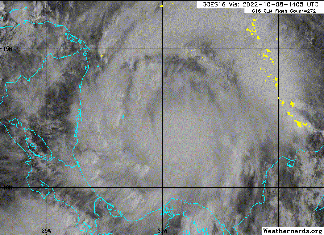
Re: ATL: JULIA - Tropical Storm - Discussion
cheezyWXguy wrote:GCANE wrote:Flight level winds look to be picking up. Almost 60 knts peak
And for once it’s not significantly removed from the center. This could finally be the center that sticks.
Looks better, especially with that high rain rate
1 likes

Re: ATL: JULIA - Tropical Storm - Discussion
With how discombobulated the center has been, I’m getting doubtful Julia will peak at more than 70-75 kt. Its structure has a long way to go — there’s not even part of an eyewall yet — and very little time to improve. Also, I think there might still be a bit of shear in one of the levels, because the center looks to be partially exposed again.
2 likes
Irene '11 Sandy '12 Hermine '16 5/15/2018 Derecho Fay '20 Isaias '20 Elsa '21 Henri '21 Ida '21
I am only a meteorology enthusiast who knows a decent amount about tropical cyclones. Look to the professional mets, the NHC, or your local weather office for the best information.
I am only a meteorology enthusiast who knows a decent amount about tropical cyclones. Look to the professional mets, the NHC, or your local weather office for the best information.
Re: ATL: JULIA - Tropical Storm - Discussion
GCANE wrote:Drop records 996mb
Down again
Also 95% RH at 850mb.
Might try and make a run for it
0 likes
Re: ATL: JULIA - Tropical Storm - Discussion
Lots of heavy convection over the high OHC pool, east of the CoC of Julia.
This pulls latent heat out of the pool due to cold down drafts and pushes it into the boundary layer.
Also heats the mid layer from water to ice phase change in the updraft.
Could be enough time for all that to work into the core before landfall.
This pulls latent heat out of the pool due to cold down drafts and pushes it into the boundary layer.
Also heats the mid layer from water to ice phase change in the updraft.
Could be enough time for all that to work into the core before landfall.
0 likes
Re: ATL: JULIA - Tropical Storm - Discussion
Those 50+ knt FL winds, north of the CoC, seem to be pushing energy from the OHC pool rapidly into the core.
0 likes
-
InfernoFlameCat

- Category 5

- Posts: 1966
- Age: 21
- Joined: Mon Dec 14, 2020 10:52 am
- Location: Buford, GA
Re: ATL: JULIA - Tropical Storm - Discussion
Shear is limiting the storm. Heavy convection won’t do much good if it can’t drop the pressure of a stable llc. All it is doing is lowering the broad pressure as of right now.
0 likes
I am by no means a professional. DO NOT look at my forecasts for official information or make decisions based on what I post.
Goal: to become a registered expert over tropical and subtropical cyclones.
Goal: to become a registered expert over tropical and subtropical cyclones.
-
cheezyWXguy

- Category 5
- Posts: 5534
- Joined: Mon Feb 13, 2006 12:29 am
- Location: Dallas, TX
Re: ATL: JULIA - Tropical Storm - Discussion
Overshooting tops in the large CB now orienting themselves in a curved arc through the southeast quad. I wonder if it’s starting to form a partial eyewall in there
1 likes
-
Category5Kaiju

- Category 5
- Posts: 3357
- Age: 22
- Joined: Thu Dec 24, 2020 12:45 pm
- Location: Seattle
Re: ATL: JULIA - Tropical Storm - Discussion
InfernoFlameCat wrote:Shear is limiting the storm. Heavy convection won’t do much good if it can’t drop the pressure of a stable llc. All it is doing is lowering the broad pressure as of right now.
Would you mind clarifying where the shear is though? It seems to be right under a deep layer anticyclone according to the deep layer shear map
0 likes
Unless explicitly stated, all information covered in my posts is based on my opinions and observations. Please refer to a professional meteorologist or an accredited weather research agency otherwise, especially if serious decisions must be made in the event of a potentially life-threatening tropical storm or hurricane.
Re: ATL: JULIA - Tropical Storm - Discussion
Category5Kaiju wrote:InfernoFlameCat wrote:Shear is limiting the storm. Heavy convection won’t do much good if it can’t drop the pressure of a stable llc. All it is doing is lowering the broad pressure as of right now.
Would you mind clarifying where the shear is though? It seems to be right under a deep layer anticyclone according to the deep layer shear map
I checked the 200, 500, and 850 mbar level plots on the GFS, and all the flow is in the same direction. I’m not sure what level this shear is and what’s causing it, but it sure is apparent on satellite imagery. I had a suspicion shear would be an unexpected limiting factor for Julia after yesterday’s convective burst got blown off.
1 likes
Irene '11 Sandy '12 Hermine '16 5/15/2018 Derecho Fay '20 Isaias '20 Elsa '21 Henri '21 Ida '21
I am only a meteorology enthusiast who knows a decent amount about tropical cyclones. Look to the professional mets, the NHC, or your local weather office for the best information.
I am only a meteorology enthusiast who knows a decent amount about tropical cyclones. Look to the professional mets, the NHC, or your local weather office for the best information.
-
galaxy401

- Category 5
- Posts: 2299
- Age: 28
- Joined: Sat Aug 25, 2012 9:04 pm
- Location: Casa Grande, Arizona
Re: ATL: JULIA - Tropical Storm - Discussion
Considering it's moving over 20 mph, perhaps the fast forward motion is causing Julia to struggle forming a solid well-organized LLC.
2 likes
Got my eyes on moving right into Hurricane Alley: Florida.

-
Hypercane_Kyle

- Category 5
- Posts: 2899
- Joined: Sat Mar 07, 2015 7:58 pm
- Location: Cape Canaveral, FL
Re: ATL: JULIA - Tropical Storm - Discussion
Running out of time. Might only just barely make to hurricane status at landfall.
0 likes
My posts are my own personal opinion, defer to the National Hurricane Center (NHC) and other NOAA products for decision making during hurricane season.
Re: ATL: JULIA - Tropical Storm - Discussion
galaxy401 wrote:Considering it's moving over 20 mph, perhaps the fast forward motion is causing Julia to struggle forming a solid well-organized LLC.
Maybe, but that doesn’t explain why shear is coming from the north, perpendicular to the storm’s motion and the flows at the 200mb, 500mb, and 850mb levels. If fast forward speed was the main problem, wouldn’t the shear vector be close to horizontal and not vertical?
0 likes
Irene '11 Sandy '12 Hermine '16 5/15/2018 Derecho Fay '20 Isaias '20 Elsa '21 Henri '21 Ida '21
I am only a meteorology enthusiast who knows a decent amount about tropical cyclones. Look to the professional mets, the NHC, or your local weather office for the best information.
I am only a meteorology enthusiast who knows a decent amount about tropical cyclones. Look to the professional mets, the NHC, or your local weather office for the best information.
-
cheezyWXguy
- Category 5
- Posts: 5534
- Joined: Mon Feb 13, 2006 12:29 am
- Location: Dallas, TX
Re: ATL: JULIA - Tropical Storm - Discussion
This pass shows a lot more consolidated circulation. Whatever shear there is shouldn’t be enough to stop this from wrapping convection back around to the north eventually.
0 likes

-
Sciencerocks
- Category 5
- Posts: 7286
- Age: 38
- Joined: Thu Jul 06, 2017 1:51 am
Who is online
Users browsing this forum: No registered users and 72 guests